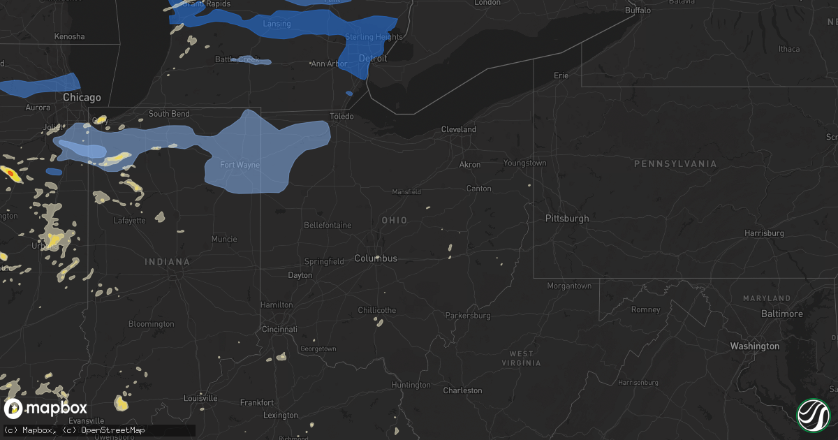
Hail Map in Ohio on August 29, 2022
Get this storm
August 29 map
$229
one time, instant access
Download today. No call, no setup
Keep the $229
Bought the map and want the full workflow? Apply the entire $229 to a subscription within 7 days. None of it is wasted.
Every map, not just this one
This buys you this map. Subscription and you get every map we run, in the markets you choose from a few cities to whole states to nationwide. Plus real-time alerts the moment a storm fires.
Contact data
Name, contact info, occupancy, even credit band for addresses in the footprint. You go from where it hit to who to call.
Become the source they trust
Unlimited branding weather history reports on demand. You already have the documented answer ready for the property owner, and you are the one who showed up with it.
Property data and RoofTrace estimates
Pull up any address you have got, its value and the exact code rules for that jurisdiction, straight from One Click Code. Then RoofTrace estimates the squares, pitch, and roof value, priced the way you price.
Storm reports in Ohio
Ohio
| Date | Description |
|---|---|
| 08/29/20226:50 PM CDT | A tree was blown down blocking a roadway near hwy 128 and hwy 65. Time was estimated by radar. |
| 08/29/20226:08 PM CDT | Power pole was snapped near the intersection of crestview and cloverdale. Power reported out. |
| 08/29/20226:04 PM CDT | Several trees down around put-in-bay. |
| 08/29/20225:50 PM CDT | Corrects previous tstm wnd dmg report from 1 ssw fremont. A tree was blown down blocking a roadway near hwy 128 and hwy 65. Time was estimated by radar. Corrected for t |
| 08/29/20225:45 PM CDT | Several reports of trees blown down. One tree was blocking state route 19. An outbuilding or shed was blown onto state route 19 near oak harbor. Power poles and line we |
| 08/29/20225:45 PM CDT | Multiple large limbs down and 45ft tv tower toppled over with damage to nearby residence. Measured wind gust of 57 mph. Time estimated via radar. |
| 08/29/20225:40 PM CDT | 60 slate shingles blown off of the performing arts center. |
| 08/29/20225:30 PM CDT | Large grain bin top ripped off. |
| 08/29/20225:20 PM CDT | A large tree on power lines and blocking road at wasaon and segur roads. |
| 08/29/20225:18 PM CDT | Tree down on county rd 53 south of us 62. Time estimated via radar. |
| 08/29/20225:15 PM CDT | Snapped power pole at pawnee rd and mcgregor ln. |
| 08/29/20225:14 PM CDT | Large branch blocking road. Time estimated via radar. |
| 08/29/20225:14 PM CDT | Multiple large trees uprooted. Time estimated via radar. |
| 08/29/20225:10 PM CDT | *** 1 fatal *** a tree fell on a woman near the intersection of copland street and beverly drive resulting in a fatality. Time was estimated by reports and radar. |
| 08/29/20225:05 PM CDT | Large tree down across roadway. Time estimated via radar. |
| 08/29/20225:04 PM CDT | Power pole down on vehicle and wires near sr 64 and airport highway. Time estimated via radar. |
| 08/29/20224:58 PM CDT | Corrects previous tstm wnd gst report from toledo express airport. Asos station ktol toledo measured a 51 kt thunderstorm wind gust. Corrected for time. |
| 08/29/20224:55 PM CDT | Various instances of tree damage and power pole damage with lines in the across the county including at this location. |
| 08/29/20224:44 PM CDT | Several tree limbs down on county road 16-3 between county roads t and tu. |
| 08/29/20224:32 PM CDT | Several trees and tree limbs down in and around defiance. |
| 08/29/20224:30 PM CDT | 3 to 6 inch tree limbs down across the town. |
| 08/29/20224:27 PM CDT | Numerous trees down blocking the road. |
| 08/29/20224:25 PM CDT | Large tree limb blocking a road. |
| 08/29/20224:20 PM CDT | Emergency management reports 8 power poles downed and 2 trees damaged due to straight line thunderstorm winds near cecil... Ohio in paulding county. |
| 08/29/20224:15 PM CDT | Tree limbs down west of pioneer on us-20. |
| 08/29/20224:15 PM CDT | Corrects previous tstm wnd dmg report from 2 wsw montpelier. Numerous trees down blocking the road. |
| 08/29/20224:13 PM CDT | Numerous trees down in area of co rd k and co rd 10. Time estimated via radar. |
| 08/29/20224:10 PM CDT | Estimated 50 to 60 mph. |
| 08/29/20223:58 PM CDT | Asos station ktol toledo measured a 51 kt thunderstorm wind gust. |
| 08/29/20222:05 PM CDT | Numerous trees down on lakeside drive. Time given was observed. |
| 08/29/20222:08 AM CDT | At 708 PM EDT, severe thunderstorms were located along a line extending from Kelleys Island to near New Riegel, moving east at 45 mph. HAZARD...60 mph wind gusts and penny size hail. SOURCE...Trained weather spotters. These thunderstorms have a history of producing wind damage across northwest Ohio. IMPACT...Expect damage to trees and power lines. Locations impacted include... Sandusky, Norwalk, Western Vermilion, Vermilion, Kelleys Island, Bellevue, Willard, New London, Plymouth, Northern Milan, Milan, Wakeman, Castalia, Greenwich, Monroeville, Marblehead, Berlin Heights, North Fairfield, Bloomingville and Sandusky South. |
| 08/29/20222:02 AM CDT | At 701 PM EDT, severe thunderstorms were located along a line extending from 9 miles northwest of Tiffin to near Vanlue, moving east at 45 mph. HAZARD...60 mph wind gusts. SOURCE...Radar indicated. IMPACT...Expect damage to trees and power lines. Locations impacted include... Tiffin, Green Springs, Bloomville, New Riegel, Attica, Bettsville, Republic, Flat Rock, Bascom and Kansas. |
| 08/29/20221:24 AM CDT | At 623 PM EDT, severe thunderstorms were located along a line extending from near Oregon to near North Baltimore, moving east at 40 mph. HAZARD...60 mph wind gusts. SOURCE...Trained weather spotters. Numerous reports of tree and power-line damage have been received in Lucas County. IMPACT...Expect damage to trees and power lines. Locations impacted include... Fremont, Port Clinton, Kelleys Island, Put-In-Bay, Bellevue, Clyde, Oak Harbor, Gibsonburg, Genoa, Woodville, Elmore, Green Springs, Ballville, Catawba Island, Marblehead, Bay View, Risingsun, Lindsey, Rocky Ridge and Clay Center. |
| 08/29/20221:09 AM CDT | At 608 PM EDT, severe thunderstorms were located along a line extending from near Deshler to 6 miles south of Columbus Grove, moving east at 45 mph. HAZARD...60 mph wind gusts. SOURCE...Emergency management. Multiple reports of tree damage have been receieved from this line of storms in Henry and Van Wert Counties. IMPACT...Expect damage to trees and power lines. Locations impacted include... Findlay, Fostoria, Bluffton, North Baltimore, McComb, Arlington, Arcadia, Rawson, Vanlue, Van Buren, Bloomdale, Mount Blanchard, Benton Ridge, Jenera, Mount Cory, Bairdstown and Williamstown. |
| 08/29/202212:47 AM CDT | At 547 PM EDT, severe thunderstorms were located along a line extending from 8 miles southwest of Blissfield to near Holgate, moving east at 50 mph. HAZARD...60 mph wind gusts. SOURCE...Emergency management. Tree damage was reported in Wauseon. IMPACT...Expect damage to trees and power lines. Locations impacted include... Toledo, Bowling Green, Fostoria, Perrysburg, Oregon, Sylvania, Rossford, Waterville, Northwood, Whitehouse, North Baltimore, Holland, Weston, Maumee, Ottawa Hills, Walbridge, Pemberville, Millbury, Haskins and Luckey. |
| 08/29/202212:21 AM CDT | At 521 PM EDT, severe thunderstorms were located along a line extending from near Brooklyn to near Hudson to near Holiday City, moving east at 45 mph. HAZARD...60 mph wind gusts. SOURCE...Radar indicated. IMPACT...Expect damage to roofs, siding, and trees. Severe thunderstorms will be near... Onsted and Cement City around 525 PM EDT. Clayton around 530 PM EDT. Morenci around 540 PM EDT. Adrian around 545 PM EDT. Tecumseh around 550 PM EDT. Deerfield and Britton around 600 PM EDT. Blissfield and Petersburg around 605 PM EDT. Milan, Dundee and Ottawa Lake around 610 PM EDT.Other locations impacted by these severe thunderstorms includeNewport, Manitou Beach-Devils Lake, Ogden Center, Canandaigua, Erie,Woodland Beach, Stony Point, Ridgeway, Palmyra and Bolles Harbor. |
| 08/29/202212:04 AM CDT | At 503 PM EDT, severe thunderstorms were located along a line extending from near Edgerton to near Woodburn to 6 miles northeast of Ossian, moving east at 50 mph. HAZARD...70 mph wind gusts. SOURCE...Radar indicated. IMPACT...Expect considerable tree damage. Damage is likely to mobile homes, roofs, and outbuildings. Locations impacted include... Defiance, Van Wert, Decatur, Hicksville, Paulding, Antwerp, Woodburn, Monroeville, Payne, Continental, Convoy, Ottoville, Monroe, Ohio City, Oakwood, Middlebury, Farmer, Middle Point, Dixon and Grover Hill. |
| 08/28/202211:42 PM CDT | At 441 PM EDT, severe thunderstorms were located along a line extending from near Quincy to 6 miles west of Hamilton, moving east at 55 mph. HAZARD...60 mph wind gusts. SOURCE...Radar indicated. IMPACT...Expect damage to roofs, siding, and trees. Locations impacted include... Coldwater, Angola, Bryan, Hillsdale, Montpelier, Butler, Jonesville, Waterloo, Fremont, Edgerton, West Unity, Quincy, Hamilton, Pioneer, Litchfield, Stryker, Reading, Edon, Holiday City and Edgerton In Williams County.This includes the following highways... Interstate 69 in Indiana between mile markers 334 and 357. Interstate 69 in Michigan between mile markers 1 and 21. Interstate 80 in Indiana between mile markers 139 and 156. Interstate 80 in Ohio between mile markers 0 and 22. |
| 08/28/202211:34 PM CDT | At 433 PM EDT, severe thunderstorms were located along a line extending from near Avilla to 6 miles north of Huntington, moving east at 50 mph. HAZARD...70 mph wind gusts. SOURCE...Radar indicated. IMPACT...Expect considerable tree damage. Damage is likely to mobile homes, roofs, and outbuildings. Locations impacted include... Fort Wayne, Huntington, New Haven, Auburn, Bluffton, Decatur, Garrett, Ossian, Butler, Huntertown, Waterloo, Woodburn, Monroeville, Andrews, Markle, Grabill, Monroe, St. Joe, Aboite and Leo-cedarville.This includes the following highways... Interstate 469 between mile markers 0 and 30. Interstate 69 in Indiana between mile markers 284 and 335. |
| 08/28/202211:07 PM CDT | At 407 PM EDT, severe thunderstorms were located along a line extending from 6 miles north of Centreville to Millersburg, moving east at 55 mph. HAZARD...60 mph wind gusts. SOURCE...Radar indicated. IMPACT...Expect damage to roofs, siding, and trees. Locations impacted include... Sturgis, Coldwater, Kendallville, Angola, Three Rivers, Ligonier, Lagrange, Bronson, Fremont, Quincy, Union City, Hamilton, White Pigeon, Centreville, Rome City, Colon, Topeka, Ray, Nottawa and Girard.This includes the following highways... Interstate 69 in Indiana between mile markers 335 and 357. Interstate 69 in Michigan between mile markers 1 and 21. Interstate 80 in Indiana between mile markers 110 and 156. Interstate 80 in Ohio near mile marker 0. |
| 08/28/20229:52 PM CDT | At 252 PM EDT, a severe thunderstorm was located 9 miles north of Cadiz, moving northeast at 25 mph. HAZARD...60 mph wind gusts. SOURCE...Radar indicated. IMPACT...Expect damage to trees and power lines, resulting in some power outages. Locations impacted include... Steubenville, Wintersville, Jewett, Amsterdam, Richmond, and Unionport. |
| 08/28/20228:36 PM CDT | At 136 PM EDT, a severe thunderstorm was located over East Palestine, moving east at 30 mph. HAZARD...60 mph wind gusts and quarter size hail. SOURCE...Radar indicated. IMPACT...Minor hail damage to vehicles is possible. Expect wind damage to trees and power lines, resulting in some power outages. Locations impacted include... Cranberry, New Castle, Beaver Falls, Columbiana, Monaca, East Palestine, Economy, Ellwood City, New Brighton, Beaver, Calcutta, and Zelienople. |
| 08/28/20227:47 PM CDT | Tree down on car. Time estimated via radar. |
| 08/28/20227:44 PM CDT | Tree down blocking road near humphrey hill dr and pinecrest rd. |
| 08/28/20227:15 PM CDT | Five trees down on poe road near fox meadow drive. |
All States Impacted by Hail Map on August 29, 2022
Cities Impacted by Hail Map on August 29, 2022
- Watervliet, MI
- Allegan, MI
- Bloomingdale, MI
- Salem, WI
- Burlington, WI
- Indianola, IA
- Big Rapids, MI
- Dalton City, IL
- Montague, MI
- Whitehall, MI
- Chelsea, MI
- Oakland, IL
- Ridge Farm, IL
- Metcalf, IL
- Indianola, IL
- Brocton, IL
- Catlin, IL
- Georgetown, IL
- Hume, IL
- Chrisman, IL
- Newman, IL
- Fennville, MI
- Hamilton, MI
- Saugatuck, MI
- Holland, MI
- Douglas, MI
- Dana, IN
- Clinton, IN
- Hillsdale, IN
- Paris, IL
- Bennett, IA
- Ainsworth, IA
- Pontiac, IL
- Odell, IL
- Streator, IL
- Ancona, IL
- Wenona, IL
- Cornell, IL
- Long Point, IL
- Saunemin, IL
- Fisher, IL
- Mahomet, IL
- Franklin, IL
- New Berlin, IL
- Jacksonville, IL
- Alexander, IL
- Mansfield, IL
- Newark, MO
- Knox City, MO
- Decatur, IL
- Hammond, IL
- La Place, IL
- Cerro Gordo, IL
- Argenta, IL
- Elliott, IL
- Gibson City, IL
- Frankfort, KS
- Lincoln, IL
- Allerton, IL
- Broadlands, IL
- Fairfield, IL
- Clinton, MO
- Montrose, MO
- Grand Rapids, MI
- Grand Ridge, IL
- Gary, IN
- Lake Station, IN
- Seneca, IL
- Sharon, WI
- Clinton, WI
- Sibley, IL
- Beallsville, OH
- Curwensville, PA
- Clearfield, PA
- West Terre Haute, IN
- Newcomerstown, OH
- West Lafayette, OH
- Pembroke Township, IL
- Lansing, IL
- Chicago Heights, IL
- Glenwood, IL
- Munster, IN
- Highland, IN
- Monon, IN
- Delphi, IN
- Yeoman, IN
- Idaville, IN
- Monticello, IN
- Brookston, IN
- Leonard, MO
- Gibbs, MO
- Novelty, MO
- Hurdland, MO
- La Plata, MO
- Kentland, IN
- Earl Park, IN
- Fowler, IN
- Goodland, IN
- Remington, IN
- Wathena, KS
- Saint Joseph, MO
- Grand Junction, MI
- Washington, IA
- Clinton, IA
- Long Grove, IA
- McCausland, IA
- Calamus, IA
- Thomson, IL
- Bryant, IA
- Grand Mound, IA
- Charlotte, IA
- Savanna, IL
- Camanche, IA
- Preston, IA
- Eldridge, IA
- Welton, IA
- Princeton, IA
- Sabula, IA
- Miles, IA
- Delmar, IA
- De Witt, IA
- Goose Lake, IA
- Driftwood, PA
- Chatsworth, IL
- Melvin, IL
- Strawn, IL
- Beason, IL
- Everest, KS
- Lancaster, KS
- Horton, KS
- Effingham, KS
- Lone Jack, MO
- Loraine, IL
- West Point, IL
- Pleasant Hill, MO
- Kingsville, MO
- Gardner, KS
- Edgerton, KS
- Spring Hill, KS
- Gardner, IL
- Dwight, IL
- Manhattan, IL
- Elwood, IL
- Joliet, IL
- Mokena, IL
- Channahon, IL
- New Lenox, IL
- Sanford, MI
- Shepherd, MI
- Coleman, MI
- Midland, MI
- Shelbyville, MO
- Emden, MO
- Lake Village, IN
- Marne, MI
- Coopersville, MI
- Belmont, MI
- Zeeland, MI
- Rockford, MI
- Allendale, MI
- Comstock Park, MI
- Conklin, MI
- Sparta, MI
- West Olive, MI
- Waterford, WI
- Cooksville, IL
- Richland, IA
- Brighton, IA
- Warsaw, IL
- Basco, IL
- Carthage, IL
- North Judson, IN
- Demotte, IN
- Fair Oaks, IN
- Wheatfield, IN
- Rensselaer, IN
- San Pierre, IN
- Elsie, MI
- Brohman, MI
- Bitely, MI
- White Cloud, MI
- Paris, MI
- Reddick, IL
- Muscatine, IA
- Winterset, IA
- Plymouth, IN
- Bourbon, IN
- Argos, IN
- Carbon, IN
- Brazil, IN
- Hartford, MI
- Nunica, MI
- New Salem, IL
- Colchester, IL
- Wheatland, IA
- New Liberty, IA
- Morocco, IN
- Danville, IL
- Terre Haute, IN
- Lovington, IL
- Chenoa, IL
- Junction City, KS
- Murrayville, IL
- Paloma, IL
- Holden, MO
- Lakeville, OH
- Glenmont, OH
- Bethany, MO
- East Palestine, OH
- Montgomery, IN
- Cannelburg, IN
- Ashland, IL
- Herington, KS
- Offerle, KS
- Lewis, KS
- Kinsley, KS
- Valparaiso, IN
- Hobart, IN
- Tolono, IL
- Philo, IL
- Sidney, IL
- Savoy, IL
- Potomac, IL
- Saint Joseph, IL
- Rossville, IL
- Rantoul, IL
- Loda, IL
- Thomasboro, IL
- Buckley, IL
- Roberts, IL
- Paxton, IL
- Homer, IL
- Armstrong, IL
- Collison, IL
- Muncie, IL
- Urbana, IL
- Gifford, IL
- Ogden, IL
- Fairmount, IL
- Cissna Park, IL
- Champaign, IL
- Oakwood, IL
- Ludlow, IL
- Penfield, IL
- Fithian, IL
- Royal, IL
- Rankin, IL
- La Monte, MO
- Hughesville, MO
- Sedalia, MO
- Knob Noster, MO
- Pleasant Plains, IL
- Springfield, IL
- Hopedale, IL
- Minier, IL
- Barry, IL
- Genoa City, WI
- Lake Geneva, WI
- Peculiar, MO
- Columbus Junction, IA
- Crawfordsville, IA
- Columbus City, IA
- Wayland, IA
- Francesville, IN
- Winamac, IN
- Medaryville, IN
- Chillicothe, OH
- Waverly, OH
- Freeman, MO
- Stoutland, MO
- Richland, MO
- Ewing, IL
- McLeansboro, IL
- Macedonia, IL
- Dahlgren, IL
- Belle Rive, IL
- Plainwell, MI
- Otsego, MI
- Chariton, IA
- Lovilia, IA
- Russell, IA
- Melrose, IA
- Bonfield, IL
- La Porte, IN
- Minooka, IL
- Hamilton, IL
- Maroa, IL
- Virginia, IL
- Beardstown, IL
- Arenzville, IL
- Coshocton, OH
- Hamilton, MO
- Kidder, MO
- Cameron, MO
- Waverly, IL
- Chandlerville, IL
- Bath, IL
- Tallula, IL
- Loami, IL
- Marshfield, MO
- Strafford, MO
- Packwood, IA
- Fairfield, IA
- Tipton, IN
- Beloit, KS
- Mount Carroll, IL
- Lanark, IL
- Shannon, IL
- Hoisington, KS
- Olmitz, KS
- Norwalk, IA
- Saint Charles, IA
- Prole, IA
- Patterson, IA
- Martensdale, IA
- Bevington, IA
- Dexter, MO
- Bloomfield, MO
- Dixon, IA
- Cosby, MO
- Easton, MO
- Ensign, KS
- Niangua, MO
- Columbus, OH
- Culver, IN
- Knox, IN
- Pittsfield, IL
- Sullivan, IL
- Beecher, IL
- Walkerville, MI
- Hesperia, MI
- Westville, IN
- Crete, IL
- Saint John, IN
- Dyer, IN
- Piper City, IL
- Gilman, IL
- Ashkum, IL
- Danforth, IL
- Kempton, IL
- Blakesburg, IA
- Ottumwa, IA
- Drakesville, IA
- Albia, IA
- Bloomfield, IA
- Moravia, IA
- Agency, IA
- Unionville, IA
- Barnard, KS
- Seymour, MO
- Bethesda, OH
- Iuka, IL
- Dix, IL
- Walnut Hill, IL
- Kell, IL
- Dodge City, KS
- Circleville, OH
- Ramona, KS
- Hope, KS
- Joelton, TN
- Goodlettsville, TN
- Whites Creek, TN
- Jeffersonville, IN
- Yukon, OK
- Wayne City, IL
- Burkesville, KY
- Norman, OK
- Huntingburg, IN
- Verden, OK
- Chickasha, OK
- Spearville, KS
- Richmond, KY
- Louisville, KY
- Fairdale, KY
- Fort Sumner, NM
- Pond Creek, OK
- Kremlin, OK
- Big Clifty, KY
- Pawnee, OK
- Amarillo, TX
- Geary, OK
- Calumet, OK
- Broseley, MO
- Melbourne, AR
- Sage, AR
- Ozark, AR
- Cleveland, OK
- Stillwater, OK
- Coyle, OK
- Perkins, OK
- Cache, OK
- Indiahoma, OK
- Skiatook, OK
- Fort Cobb, OK
- Barnsdall, OK
- Milnesand, NM
- Morton, TX
- Tatum, NM
- Tulia, TX
- Mustang, OK
- Gotebo, OK
- Mountain View, OK
- Elida, NM
- Abernathy, TX
- Happy, TX
- Weir, KS
- Anson, TX
- Reeds Spring, MO
- Whiteface, TX
- Pecos, TX
- Childress, TX
- Matador, TX
- Otis, KS
- Bison, KS
- Alexander, KS
- Bazine, KS
- Chaffee, MO
- Lockney, TX
- Floydada, TX
- Loving, NM
- Idalou, TX
- Petersburg, TX
- Apache, OK
- Quincy, IL
- Ellsworth, KS
- Kanopolis, KS
- Meade, KS
- Plains, KS
- Turpin, OK
- Forgan, OK
- Kismet, KS
- Anton, TX
- Levelland, TX
- Great Bend, KS
- Ewing, MO
- Maljamar, NM
- Lovington, NM
- Muleshoe, TX
- Sudan, TX
- Earth, TX
- Oran, MO
- Advance, MO
- Whitewater, MO
- Cape Girardeau, MO
- Booker, TX
- Nixa, MO
- Clever, MO
- Vinson, OK
- Seminole, OK
- Prague, OK
- Nazareth, TX
- Hart, TX
- Dimmitt, TX
- Ropesville, TX
- Meadow, TX
- Lorenzo, TX
- Tokio, TX
- Plains, TX
- Denver City, TX
- Crowell, TX
- Vernon, TX
- La Crosse, KS
- Bland, MO
- Balko, OK
- La Grange, MO
- Monticello, MO
- Lewistown, MO
- Canton, MO
- Payson, IL
- Taylor, MO
- Maywood, MO
- Palmyra, MO
- Durham, MO
- Philadelphia, MO
- Flomot, TX
- Wright, KS
- Odell, TX
- Capitan, NM
- Nekoma, KS
- Ness City, KS
- Albert, KS
- Winchester, KY
- Irvine, KY
- Amoret, MO
- Warrensburg, MO
- Billings, MO
- Republic, MO
- Enid, OK
- Hominy, OK
- Silverton, TX
- Blanchard, OK
- Amber, OK
- Owasso, OK
- Collinsville, OK
- Claremore, OK
- Jerico Springs, MO
- Lamar, MO
- Sheldon, MO
- Stockton, MO
- Ada, OK
- Canyon, TX
- Claude, TX
- Longview, IL
- Sutter, IL
- Lawton, OK
- Glencoe, OK
- Rosedale, IN
- Anadarko, OK
- Gracemont, OK
- Lebanon, MO
- Spearman, TX
- Kress, TX
- Plainview, TX
- Hamlin, TX
- Tecumseh, OK
- Shawnee, OK
- Linden, TN
- Wilson, KS
- Mulhall, OK
- Rogers, NM
- Eskridge, KS
- Paxico, KS
- Alma, KS
- Dumas, TX
- Sunray, TX
- Brownfield, TX
- Perryton, TX
- Oreana, IL
- Crosbyton, TX
- Frederick, OK
- Garden City, MO
- Dale, IN
- Lincoln City, IN
- Gentryville, IN
- Santa Claus, IN
- Holland, IN
- Ferdinand, IN
- Hoopeston, IL
- Blue Mound, IL
- Moweaqua, IL
- Macon, IL
- Stonington, IL
- Stratford, TX
- Wellsville, KS
- Rule, TX
- Owensville, IN
- Poseyville, IN
- Griffin, IN
- Mount Carmel, IL
- New Harmony, IN
- Dorrance, KS
- Bunker Hill, KS
- Ford, KS
- Hanston, KS
- Harrisonville, MO
- Johnsonville, IL
- Bluford, IL
- Sims, IL
- Mount Vernon, IL
- Opdyke, IL
- Keenes, IL
- Elgin, OK
- Jal, NM
- Paducah, TX
- Old Glory, TX
- Hobbs, NM
- Bethel, MO
- La Belle, MO
- El Dorado Springs, MO
- Milo, MO
- Scammon, KS
- Charleston, MO
- Mountain Grove, MO
- Berea, KY
- Waco, KY
- Vinita, OK
- Lindsay, OK
- Purcell, OK
- Centerville, TN
- Earlsboro, OK
- Lexington, OK
- Noble, OK
- Washington, OK
- Van Horn, TX
- Latham, IL
- Chestnut, IL
- Kenney, IL
- Cross Plains, IN
- Dubois, IN
- Butler, MO
- Walnut, KS
- Ribera, NM
- Eldorado, OK
- Elmer, OK
- Norwich, OH
- Graymont, IL
- Jetmore, KS
- Temple, OK
- Marble Hill, MO
- Claflin, KS
- Greensburg, KS
- Watonga, OK
- Emporia, KS
- Saint Anthony, IN
- Madison, IN
- Nowata, OK
- Hartville, MO
- Foster, MO
- Amsterdam, MO
- Omaha, AR
- Hollister, MO
- Stendal, IN
- Lamar, IN
- Sierra Blanca, TX
- Dalhart, TX
- Ellington, MO
- Hitchcock, OK
- Sweetwater, TX
- Panhandle, TX
- Springdale, AR
- Fayetteville, AR
- Tinnie, NM
- Fort Hancock, TX
- Paint Rock, TX
- Russellville, AL
- Tuscumbia, AL
- Orlando, OK
- Crescent, OK
- Guthrie, OK
- Farwell, TX
- Cedarbluff, MS
- Littlefield, TX
- Lubbock, TX
- Spur, TX
- Tell, TX
- Gallatin, MO
- Terlton, OK
- Rush Center, KS
- Golden Gate, IL
- Ellery, IL
- Albion, IL
- Gruver, TX
- Wanette, OK
- Salt Flat, TX
- Mentone, TX
- Post, TX
- Amherst, TX
- Weed, NM
- Gerald, MO
- Rosebud, MO
- Ottawa, KS
- Chilhowee, MO
- French Lick, IN
- West Baden Springs, IN
- Jasper, IN
- Adamsville, OH
- Centerview, MO
- Atwood, IL
- Pawnee Rock, KS
- Keota, OK
- Laredo, MO
- Chula, MO
- Alex, OK
- Oronogo, MO
- Liberal, MO
- Rozel, KS
- Omega, OK
- Hamersville, OH
- Bethel, OH
- Hurricane Mills, TN
- Waverly, TN
- Oklahoma City, OK
- Alton, MO
- Elkins, AR
- Paden, OK
- Mcloud, OK
- Newalla, OK
- Faxon, OK
- Whiteman Air Force Base, MO
- Ralls, TX
- Crane, MO
- Bartlesville, OK
- Pawhuska, OK
- Clay City, KY
- Olton, TX
- Maple, TX
- New Haven, MO
- Leslie, MO
- Gail, TX
- Roscoe, TX
- De Mossville, KY
- Falmouth, KY
- Perry, OK
- Mount Erie, IL
- West Salem, IL
- Eminence, MO
- Aurora, MO
- Prescott, KS
- Pleasanton, KS
- Mound City, KS
- Jeffersonville, KY
- Fowler, KS
- Louisa, KY
- Fort Sill, OK
- Shell Knob, MO
- Kimberling City, MO
- Aberdeen, MS
- Breckenridge, MO
- Dry Ridge, KY
- Willisburg, KY
- Blue Rapids, KS
- Golconda, IL
- Lerna, IL
- Belle, MO
- Owensville, MO
- Williamstown, KY
- Morning View, KY
- Butler, KY
- Crittenden, KY
- Hampton, KY
- Smithland, KY
- Grovespring, MO
- Grand Rivers, KY
- Goreville, IL
- Maple Hill, KS
- Foster, WV
- Danville, WV
- Julian, WV
- Chapmanville, WV
- Harts, WV
- Big Creek, WV
- New Florence, MO
- Hermann, MO
- River, KY
- Meally, KY
- Tomahawk, KY
- Boons Camp, KY
- Paintsville, KY
- Bellmont, IL
- Browns, IL
- Grayville, IL
- Tuttle, OK
- Tulsa, OK
- Jennings, OK
- Olmsted, IL
- Kevil, KY
- Villa Ridge, IL
- Grand Chain, IL
- Rush Springs, OK
- Powell, MO
- Florence, AL
- Sugar Tree, TN
- Prue, OK
- Quitaque, TX
- Shallowater, TX
- Loveland, OK
- Oologah, OK
- Cyril, OK
- Plantersville, MS
- Fulton, MS
- Tupelo, MS
- Onarga, IL
- Blackstone, IL
- Kinsman, IL
- Forest, IN
- Michigantown, IN
- Frankfort, IN
- Burlington, IN
- Russiaville, IN
- Cutler, IN
- Bringhurst, IN
- Flora, IN
- Kokomo, IN
- Cape Fair, MO
- Galena, MO
- Shoals, IN
- Goodwell, OK
- Wheeling, MO
- Alden, MN
- Hartland, MN
- Albert Lea, MN
- Grand Meadow, MN
- Ridgeview, WV
- Russell, KS
- Tahoka, TX
- Smyer, TX
- Wolfforth, TX
- Turkey, TX
- Clarendon, TX
- Lakeview, TX
- Wilmette, IL
- Chicago, IL
- Streamwood, IL
- Hanover Park, IL
- Lincolnwood, IL
- Kenilworth, IL
- Roselle, IL
- Bensenville, IL
- Kingston, IL
- Sycamore, IL
- Schaumburg, IL
- Arlington Heights, IL
- Winnetka, IL
- Wayne, IL
- Mount Prospect, IL
- Wasco, IL
- Palatine, IL
- Evanston, IL
- Park Ridge, IL
- Golf, IL
- Wood Dale, IL
- Wheeling, IL
- South Elgin, IL
- Maple Park, IL
- Saint Charles, IL
- Skokie, IL
- Rolling Meadows, IL
- Hoffman Estates, IL
- Malta, IL
- Hampshire, IL
- Addison, IL
- Franklin Park, IL
- West Chicago, IL
- Elgin, IL
- Niles, IL
- Burlington, IL
- Itasca, IL
- Dekalb, IL
- Schiller Park, IL
- Carol Stream, IL
- Glendale Heights, IL
- Elk Grove Village, IL
- Cortland, IL
- Kirkland, IL
- Harwood Heights, IL
- Glenview, IL
- Bloomingdale, IL
- Glencoe, IL
- Medinah, IL
- Highland Park, IL
- Esmond, IL
- Clare, IL
- Barrington, IL
- Bartlett, IL
- Northbrook, IL
- Elburn, IL
- Prospect Heights, IL
- Des Plaines, IL
- Genoa, IL
- Morton Grove, IL
- Churubusco, IN
- Convoy, OH
- Rudolph, OH
- Continental, OH
- Waterville, OH
- Hazel Crest, IL
- Arcola, IN
- Craigville, IN
- South Whitley, IN
- Ligonier, IN
- Montpelier, OH
- Manteno, IL
- North Webster, IN
- Crown Point, IN
- New Haven, IN
- Larwill, IN
- Thayer, IN
- Lakeville, IN
- Angola, IN
- Hamilton, IN
- Leo, IN
- Bowling Green, OH
- Wauseon, OH
- Steger, IL
- Huntington, IN
- Griffith, IN
- Syracuse, IN
- Hicksville, OH
- Wakarusa, IN
- La Crosse, IN
- Zanesville, IN
- Middle Point, OH
- Grelton, OH
- New Bavaria, OH
- Defiance, OH
- Milford, IN
- Ney, OH
- Monclova, OH
- Holgate, OH
- Warsaw, IN
- Decatur, IN
- Oakwood, OH
- Saint Joe, IN
- Delphos, OH
- Ossian, IN
- Deshler, OH
- Country Club Hills, IL
- Van Wert, OH
- Rome City, IN
- Haviland, OH
- Fremont, IN
- Boone Grove, IN
- Leesburg, IN
- Flossmoor, IL
- Richton Park, IL
- Urbana, IN
- Kingsford Heights, IN
- Andrews, IN
- Ohio City, OH
- Laotto, IN
- Auburn, IN
- Etna Green, IN
- Mark Center, OH
- Edgerton, OH
- Nappanee, IN
- Grant Park, IL
- Fort Jennings, OH
- Cromwell, IN
- Pleasant Lake, IN
- Stryker, OH
- Hudson, IN
- Venedocia, OH
- Monroeville, IN
- Napoleon, OH
- Merrillville, IN
- Waterloo, IN
- Tinley Park, IL
- Custar, OH
- Bradley, IL
- Hamler, OH
- Huntertown, IN
- Bluffton, IN
- Grovertown, IN
- Monee, IL
- Union Mills, IN
- Park Forest, IL
- Lagrange, IN
- Columbia City, IN
- Albion, IN
- Frankfort, IL
- Neapolis, OH
- North Liberty, IN
- Scott, OH
- Monroe, IN
- Evansport, OH
- Cedar Lake, IN
- Kendallville, IN
- Matteson, IL
- Kankakee, IL
- Goshen, IN
- Willshire, OH
- Sherwood, OH
- Wolcottville, IN
- Bryan, OH
- Peotone, IL
- Wilmington, IL
- South Milford, IN
- North Manchester, IN
- Hamlet, IN
- Edon, OH
- Uniondale, IN
- Wawaka, IN
- Spencerville, IN
- University Park, IL
- Pierceton, IN
- Thornton, IL
- Kimmell, IN
- Latty, OH
- Olympia Fields, IL
- Roanoke, IN
- Fort Wayne, IN
- Schneider, IN
- Antwerp, OH
- Melrose, OH
- Tontogany, OH
- McClure, OH
- Ridgeville Corners, OH
- Shelby, IN
- Bremen, IN
- Harlan, IN
- Delta, OH
- Bourbonnais, IL
- Paulding, OH
- Grover Hill, OH
- Corunna, IN
- Milton Center, OH
- Wren, OH
- Avilla, IN
- Garrett, IN
- Liberty Center, OH
- Grand Rapids, OH
- Archbold, OH
- New Paris, IN
- Hoagland, IN
- Schererville, IN
- Hebron, IN
- Swanton, OH
- Markle, IN
- Lowell, IN
- Whitehouse, OH
- Cecil, OH
- Hanna, IN
- Cloverdale, OH
- Ashley, IN
- Malinta, OH
- Grabill, IN
- Wanatah, IN
- Woodburn, IN
- Homewood, IL
- Weston, OH
- Momence, IL
- Payne, OH
- Kouts, IN
- Yoder, IN
- Butler, IN
- Walkerton, IN
- Chebanse, IL
- Clifton, IL
- Buckingham, IL
- Herscher, IL
- Cabery, IL
- Washington, MO
- Clawson, MI
- Ecorse, MI
- Haslett, MI
- Owosso, MI
- Utica, MI
- Linden, MI
- Romulus, MI
- Melvindale, MI
- Hamtramck, MI
- Clinton Township, MI
- Ray, MI
- Fraser, MI
- Leonard, MI
- Ypsilanti, MI
- Perry, MI
- Vermontville, MI
- Rockwood, MI
- Commerce Township, MI
- Eastpointe, MI
- Howell, MI
- Mason, MI
- Saint Clair Shores, MI
- River Rouge, MI
- Charlotte, MI
- Potterville, MI
- Northville, MI
- Madison Heights, MI
- Lake Orion, MI
- Grosse Pointe, MI
- Milford, MI
- Macatawa, MI
- Dansville, MI
- Casco, MI
- Portland, MI
- Fenton, MI
- Livonia, MI
- Eaton Rapids, MI
- Center Line, MI
- Gaines, MI
- Fair Haven, MI
- Riverview, MI
- Romeo, MI
- Oak Park, MI
- Clarkston, MI
- Trenton, MI
- Berkley, MI
- Lowell, MI
- Waterford, MI
- Wayland, MI
- Walled Lake, MI
- Dearborn, MI
- Sunfield, MI
- Huntington Woods, MI
- Canton, MI
- Spring Lake, MI
- Dimondale, MI
- Southfield, MI
- Taylor, MI
- Byron, MI
- Belleville, MI
- Roseville, MI
- Swartz Creek, MI
- Highland Park, MI
- Redford, MI
- Freeport, MI
- East Lansing, MI
- Williamston, MI
- Franklin, MI
- Lansing, MI
- Morrice, MI
- Flat Rock, MI
- Grosse Ile, MI
- Warren, MI
- New Haven, MI
- Hastings, MI
- Wayne, MI
- Inkster, MI
- Richmond, MI
- Grandville, MI
- Macomb, MI
- Lincoln Park, MI
- Novi, MI
- Royal Oak, MI
- Laingsburg, MI
- Mulliken, MI
- Wyandotte, MI
- Oakland, MI
- Hazel Park, MI
- Brighton, MI
- Pleasant Ridge, MI
- Harrison Township, MI
- Bath, MI
- Highland, MI
- Webberville, MI
- Alto, MI
- Ferndale, MI
- Keego Harbor, MI
- Eagle, MI
- Armada, MI
- New Boston, MI
- Mount Clemens, MI
- Bancroft, MI
- Fowlerville, MI
- Harper Woods, MI
- Pontiac, MI
- Allen Park, MI
- Holly, MI
- West Bloomfield, MI
- Dorr, MI
- Southgate, MI
- Plymouth, MI
- Farmington, MI
- Bloomfield Hills, MI
- Clarksville, MI
- Holt, MI
- Middleville, MI
- Hartland, MI
- Grand Blanc, MI
- Caledonia, MI
- Birmingham, MI
- Washington, MI
- Byron Center, MI
- Garden City, MI
- Woodland, MI
- Durand, MI
- Sterling Heights, MI
- Wyoming, MI
- Davisburg, MI
- Okemos, MI
- Grand Haven, MI
- Hudsonville, MI
- Grand Ledge, MI
- New Baltimore, MI
- Lake Odessa, MI
- Ada, MI
- Detroit, MI
- White Lake, MI
- Westland, MI
- Troy, MI
- Dearborn Heights, MI
- Rochester, MI
- Jenison, MI
- Dewitt, MI
- Auburn Hills, MI
- Bellevue, MI
- Marshall, MI
- Albion, MI
- Battle Creek, MI
- Parma, MI
- Ceresco, MI
- Freeland, MI
- Breckenridge, MI
- Saint Louis, MI
- Merrill, MI
- Mount Pleasant, MI
- Wheeler, MI
- Hemlock, MI
- Mount Morris, MI
- Oakley, MI
- Lapeer, MI
- Davison, MI
- Flint, MI
- New Lothrop, MI
- Saint Johns, MI
- Corunna, MI
- Bannister, MI
- Ovid, MI
- Flushing, MI
- Lennon, MI
- Ashley, MI
- Chesaning, MI
- Burton, MI
- Perrinton, MI
- Henderson, MI
- Monroe, MI
- Genesee, MI


