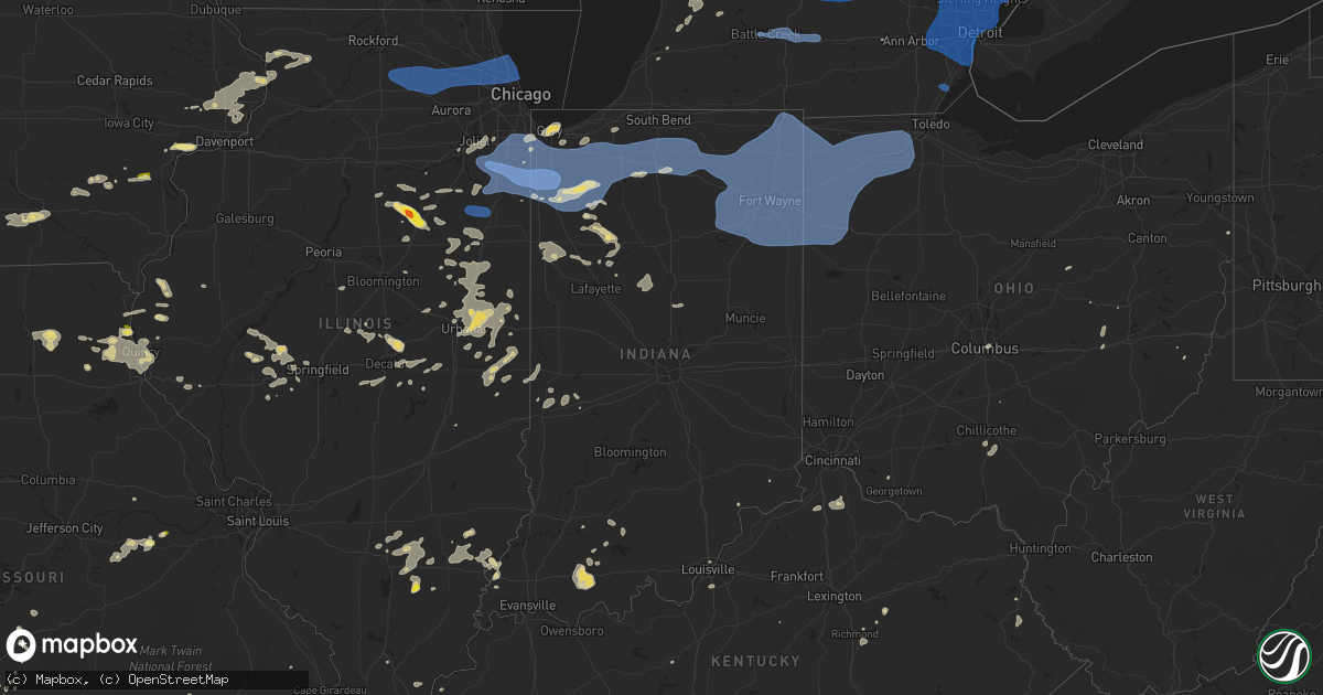
Hail Map in Indiana on August 29, 2022
Get this storm
August 29 map
$229
one time, instant access
Download today. No call, no setup
Keep the $229
Bought the map and want the full workflow? Apply the entire $229 to a subscription within 7 days. None of it is wasted.
Every map, not just this one
This buys you this map. Subscription and you get every map we run, in the markets you choose from a few cities to whole states to nationwide. Plus real-time alerts the moment a storm fires.
Contact data
Name, contact info, occupancy, even credit band for addresses in the footprint. You go from where it hit to who to call.
Become the source they trust
Unlimited branding weather history reports on demand. You already have the documented answer ready for the property owner, and you are the one who showed up with it.
Property data and RoofTrace estimates
Pull up any address you have got, its value and the exact code rules for that jurisdiction, straight from One Click Code. Then RoofTrace estimates the squares, pitch, and roof value, priced the way you price.
Storm reports in Indiana
Indiana
| Date | Description |
|---|---|
| 08/29/20225:40 PM CDT | Tree down over e st rd 156. |
| 08/29/20225:10 PM CDT | Tree knocked down across us 27 s. |
| 08/29/20224:30 PM CDT | Spencer dispatch reports trees down in gentryville and richland city. |
| 08/29/20224:05 PM CDT | 4 inch tree branches on roadway and house... Canal street east of eben street. |
| 08/29/20224:00 PM CDT | Several dispatch calls regarding tree limbs on power lines... Resulting in power outages... Downed power lines... And and inoperable traffic lights on the northwest sid |
| 08/29/20223:55 PM CDT | Awos station kanq angola. |
| 08/29/20223:55 PM CDT | Awos station kgwb auburn dekalb c. |
| 08/29/20223:55 PM CDT | A local report indicates 66 MPH wind near 5 NNW NEW HAVEN |
| 08/29/20223:55 PM CDT | 4 inch tree limb down at illinois rd. At sycamore hills parkway. |
| 08/29/20223:55 PM CDT | 8-10 tree inch limb down... Kirkland ave. Near crescent ave. Time estimated via radar. |
| 08/29/20223:54 PM CDT | 1 to 2 inch branches down onto state road 3. |
| 08/29/20223:53 PM CDT | Trees down on road at 204 n short st. |
| 08/29/20223:47 PM CDT | 4 inch tree limb down... Bass road near scott rd. Time estimated via radar. |
| 08/29/20223:45 PM CDT | 3 inch branch down on power line on 1000w. Time estimated via radar. |
| 08/29/20223:45 PM CDT | Tree limbs and powerlines down. One tree was laying on a vehicle... But no injuries were reported. |
| 08/29/20223:45 PM CDT | 1 foot tree branches down in south fremont. |
| 08/29/20223:43 PM CDT | Silver screen outdoor movie theater has 1/2 the screen torn out on sr 8 north of garrett indiana. Time estimated via radar. |
| 08/29/20223:43 PM CDT | Healthy 15 inch diameter tree broken at base reported by amateur radio. |
| 08/29/20223:40 PM CDT | Large tree down laying on car. |
| 08/29/20223:40 PM CDT | Multiple reports of trees and limbs down in the city. A stop light is also down. Spotters were also estimating 50 mph gusts as the line went through. |
| 08/29/20223:35 PM CDT | Various trees down in the area. A few of them in the road. |
| 08/29/20223:35 PM CDT | Several large pine trees snapped. Time estimated from radar. |
| 08/29/20223:35 PM CDT | Western side of the county has numerous lines limbs and branches down including this area. |
| 08/29/20223:30 PM CDT | Tree down onto power lines. Time estimated by radar. |
| 08/29/20223:29 PM CDT | Public reported damage to houses from thunderstorm winds just west of north manchester indiana in wabash county. |
| 08/29/20223:26 PM CDT | Tree down at 954 w dell rd. |
| 08/29/20223:25 PM CDT | Several trees and tree limbs... Some onto power lines and poles were found in peru... Especially in the area of state routes 19 and 24. A few structures lost roofs as w |
| 08/29/20223:25 PM CDT | Tree limbs down in the area. Spotter estimated 55 mph winds. |
| 08/29/20223:20 PM CDT | Reports of trees down from law enforcement on 300 and 400 south. Tree onto house in south whitley on broadstreet.... |
| 08/29/20223:20 PM CDT | Trees onto power lines. |
| 08/29/20223:20 PM CDT | A local report indicates 59 MPH wind near 1 E LAGRANGE |
| 08/29/20223:20 PM CDT | Tree onto power lines. |
| 08/29/20223:15 PM CDT | Tree limbs snapped at 920 anchorage road in warsaw. Estimated to be 1 to 2 ft in diameter. |
| 08/29/20223:15 PM CDT | Tree limbs down. |
| 08/29/20223:10 PM CDT | Picture shared of tree limb down at 920 anchorage rd. Time estimated by radar. |
| 08/29/20223:10 PM CDT | Trees down in this neighborhood. Some of them blocking streets. |
| 08/29/20223:09 PM CDT | Corrects previous tstm wnd gst report from 1 nne winona lake. Estimated 60 mph wind gust as well as tree down near gettysbutg ct and walnut st. |
| 08/29/20223:09 PM CDT | A local report indicates 60 MPH wind near 1 NNE WINONA LAKE |
| 08/29/20223:05 PM CDT | Scanner traffic indicated tree down onto a vehicle with 2 trapped. |
| 08/29/20223:05 PM CDT | Mesonet station gw0734 milford. |
| 08/29/20222:55 PM CDT | Report of tree onto vehicle with at least 1 person trapped. |
| 08/29/20222:55 PM CDT | Nws employee reports 45-50 mph wind gusts... With small branches down of 1-3 inches in diameter. |
| 08/29/20222:51 PM CDT | Picture of west facing football scoreboard bent to ground at rochester high school. |
| 08/29/20222:45 PM CDT | Large tree down in the road. |
| 08/29/20222:45 PM CDT | Large tree down. |
| 08/29/20222:45 PM CDT | Large tree down in this neighborhood. |
| 08/29/20222:45 PM CDT | 8 inch in diameter tree down in yard. |
| 08/29/20222:45 PM CDT | Tree down on a house at ewing and balis streets. Time estimated from radar. |
| 08/29/20222:45 PM CDT | Large tree branch snapped... Estimated to be 2 ft in diameter. Time estimated from radar. |
| 08/29/20222:40 PM CDT | Power pole down with a powerline in the street. |
| 08/29/20222:35 PM CDT | Two large trees across the road. |
| 08/29/20222:30 PM CDT | *** 1 inj *** large tree down on car. Minor injury with a paramedics check. |
| 08/29/20222:30 PM CDT | Large tree branch blocking the road. |
| 08/29/20222:27 PM CDT | Trees uprooted or damaged at various locations around knox. |
| 08/29/20222:26 PM CDT | A vehicle struck a tree on us 20 at the intersection of smilax road. There were no injuries reported. |
| 08/29/20222:20 PM CDT | Large limbs down and some bent power poles. A limb was down in the roadway in the area. |
| 08/29/20222:04 PM CDT | Large oak tree downed onto shed. Tree did appear partially rotten. Relayed via social media. |
| 08/29/20222:02 PM CDT | Trained weather spotter relayed extensive damage along state road 10 and surrounding areas from demotte to wheatfield. Healthy trees were snapped at their base... And a |
| 08/29/20222:00 PM CDT | Trained spotter reports numerous 2-3 inch branches downed west of wheatfield. |
| 08/29/20221:50 PM CDT | County dispatch relayed numerous reports of downed tree limbs across all of newton county with the most concentrated damage near roselawn. Time estimated by radar. |
| 08/29/20221:42 PM CDT | Spotter reported a gust of 81 mph on a home weather station. County dispatch relayed reports of tree damage across the county including in and around lowell... Dyer... |
| 08/29/20221:40 PM CDT | Public report of small branches downed in lowell. Relayed via mping. Time estimated by radar. |
| 08/29/20227:44 AM CDT | At 1243 PM CDT, severe thunderstorms were located along a line extending from near Yorkville to near Cornell, moving east at 50 mph. HAZARD...60 mph wind gusts and nickel size hail. SOURCE...Radar indicated. IMPACT...Expect damage to roofs, siding, and trees. Locations impacted include... Joliet, Orland Park, Tinley Park, Romeoville, Plainfield, Calumet City, Chicago Heights, Lansing, Oak Forest, Kankakee, Harvey, Lockport, New Lenox, Homer Glen, Dolton, Park Forest, Homewood, Matteson, Mokena and Bourbonnais.This includes... University of St. Francis, Channahon State Park,Chicagoland Speedway Route 66 Raceway, First Midwest BankAmphitheatre, Governors State University, Joliet Junior College,Joliet Slammers Baseball, Kankakee Community College, Kankakee CountyFairgrounds and Speedway, Kankakee River State Park, LewisUniversity, Olivet Nazarine University, Prairie State College, SouthSuburban College, Will County Fairgrounds, and North Central College. |
| 08/29/20223:46 AM CDT | At 845 PM CDT/945 PM EDT/, a severe thunderstorm was located 7 miles north of Cissna Park, or 8 miles west of Milford, moving southeast at 35 mph. HAZARD...60 mph wind gusts and nickel size hail. SOURCE...Radar indicated. IMPACT...Expect damage to roofs, siding, and trees. Locations impacted include... Watseka, Milford, Oxford, Cissna Park, Boswell, Buckley, Stockland, Crescent City, Loda, Woodland, Wellington, Ambia, Clarence, Dunnington, Claytonville and Templeton.Including the following interstate... I-57 between mile markers 265 and 276. |
| 08/29/20223:11 AM CDT | At 810 PM EDT, a severe thunderstorm was located near Monticello, moving southeast at 30 mph. HAZARD...60 mph wind gusts and quarter size hail. SOURCE...Radar indicated. IMPACT...Hail damage to vehicles is expected. Expect wind damage to roofs, siding, and trees. Locations impacted include... Logansport, Monticello, Grissom Afb, Walton, Lincoln, Galveston, Burnettsville, Clymers, Deacon, Idaville and Lake Cicott. |
| 08/29/20223:11 AM CDT | At 811 PM EDT, a severe thunderstorm was located near Monticello, moving southeast at 40 mph. HAZARD...60 mph wind gusts and quarter size hail. SOURCE...Radar indicated. IMPACT...Hail damage to vehicles is expected. Expect wind damage to roofs, siding, and trees. This severe thunderstorm will be near... Camden around 825 PM EDT. |
| 08/29/20222:15 AM CDT | At 714 PM CDT, a severe thunderstorm was located near Gifford, or 7 miles southeast of Rantoul, moving east at 20 mph. HAZARD...60 mph wind gusts and quarter size hail. SOURCE...Radar indicated. IMPACT...Hail damage to vehicles is expected. Expect wind damage to roofs, siding, and trees. This severe thunderstorm will be near... Ogden around 730 PM CDT.Other locations in the path of this severe thunderstorm includeFithian, Muncie, Potomac, Oakwood and Danville.This includes the following highways... Interstate 57 between mile markers 254 and 257. Interstate 74 between mile markers 186 and 211, and between milemarkers 216 and 220. |
| 08/28/202211:14 PM CDT | At 414 PM EDT, severe thunderstorms were located along a line extending from near Ligonier to near North Webster to near Pierceton, moving east at 50 mph. HAZARD...60 mph wind gusts. SOURCE...Radar indicated. IMPACT...Expect damage to roofs, siding, and trees. Locations impacted include... Kendallville, Columbia City, Tri-lakes, Avilla, Albion, Churubusco, Swan, Etna, Larwill, Lorane, Merriam, Blue Lake, Big Lake, Laotto, Arcola, Bear Lake, Lake Everett, Ege, Green Center and Dunfee. |
| 08/28/202210:49 PM CDT | At 349 PM EDT, severe thunderstorms were located along a line extending from near Nappanee to near Argos, moving east at 55 mph. HAZARD...60 mph wind gusts. SOURCE...Radar indicated. IMPACT...Expect damage to roofs, siding, and trees. Locations impacted include... Warsaw, Nappanee, Winona Lake, Syracuse, Milford, North Webster, Pierceton, Mentone, Etna Green, Leesburg, Cromwell, Big Barbee Lake, Ridinger Lake, Monoquet, Hoffman Lake, Atwood, Irish Lake, Lake Wawasee, Gravelton and Little Chapman Lake. |
| 08/28/202210:23 PM CDT | At 322 PM CDT, a severe thunderstorm was located over Dale, or 18 miles northeast of Boonville, moving east at 20 mph. HAZARD...60 mph wind gusts and quarter size hail. SOURCE...Radar indicated. IMPACT...Hail damage to vehicles is expected. Expect wind damage to roofs, siding, and trees. This severe thunderstorm will remain over mainly rural areas of northeastern Spencer County.This includes Interstate 64 in Indiana between Mile Markers 55 and60. |
| 08/28/20229:56 PM CDT | At 255 PM EDT/155 PM CDT/, severe thunderstorms were located along a line extending from Lincoln Hills to De Motte, moving east at 60 mph. THESE ARE DESTRUCTIVE STORMS FOR areas along and north of US30. HAZARD...80 mph wind gusts. SOURCE...Radar indicated. IMPACT...Flying debris will be dangerous to those caught without shelter. Mobile homes will be heavily damaged. Expect considerable damage to roofs, windows, and vehicles. Extensive tree damage and power outages are likely. Severe thunderstorms will be near... Wanatah around 305 PM EDT. Medaryville around 310 PM EDT. North Judson and Kingsford Heights around 315 PM EDT. Knox and Hamlet around 320 PM EDT. Winamac, Walkerton and Koontz Lake around 325 PM EDT. Plymouth and Culver around 335 PM EDT. Rochester, Bremen and Bourbon around 345 PM EDT.Other locations impacted by these severe thunderstorms include Lomax,Beardstown, Nyena Lake, Brems, Tyner, Hibbard, Tippecanoe, Clarks,Linkville and Star City. |
| 08/28/20229:39 PM CDT | At 238 PM EDT/138 PM CDT/, severe thunderstorms were located along a line extending from 16 miles northwest of St. Joseph to near New Buffalo to near Lake Station, moving east at 40 mph. HAZARD...60 mph wind gusts and quarter size hail. SOURCE...Radar indicated. IMPACT...Hail damage to vehicles is expected. Expect wind damage to roofs, siding, and trees. Locations impacted include... South Bend, Mishawaka, Michigan City, La Porte, Niles, Benton Harbor, St. Joseph, Dowagiac, Westville, Buchanan, Georgetown, Trail Creek, Gulivoire Park, Granger, Benton Heights, Fair Plain, Osceola, Bridgman, Walkerton and North Liberty.This includes the following highways... Interstate 196 between mile markers 0 and 7. Interstate 80 in Indiana between mile markers 38 and 87. Interstate 94 in Indiana between mile markers 33 and 45. Interstate 94 in Michigan between mile markers 0 and 42. |
| 08/28/20228:59 PM CDT | At 158 PM CDT, severe thunderstorms were located along a line extending from Hebron to 6 miles south of DeMotte, moving east at 55 mph. THESE ARE DESTRUCTIVE STORMS FOR DEMOTTE AND STOUTSBBURG. HAZARD...80 mph wind gusts. SOURCE...Radar indicated. IMPACT...Flying debris will be dangerous to those caught without shelter. Mobile homes will be heavily damaged. Expect considerable damage to roofs, windows, and vehicles. Extensive tree damage and power outages are likely. Locations impacted include... Valparaiso, DeMotte, Hebron, Wheatfield, Lakes of the Four Seasons, Roselawn, Boone Grove and Stoutsburg.Including the following interstate... Indiana I-65 between mile markers 227 and 230. |
| 08/28/20228:44 PM CDT | At 143 PM CDT, a severe thunderstorm was located over Ogden Dunes, or over Portage, moving east at 40 mph. HAZARD...60 mph wind gusts and quarter size hail. SOURCE...Radar indicated. IMPACT...Hail damage to vehicles is expected. Expect wind damage to roofs, siding, and trees. Locations impacted include... Gary, Portage, Chesterton, Porter, Burns Harbor, Ogden Dunes, Town of Pines, Beverly Shores and Dune Acres.Including the following interstates... Indiana I-90 between mile markers 12 and 14, and near mile marker37. Indiana I-94 between mile markers 18 and 32.This includes... Indiana Dunes State Park. |
| 08/28/20228:39 PM CDT | At 138 PM CDT, severe thunderstorms were located along a line extending from near St. John to near Hopkins Park, moving east at 65 mph. THESE ARE DESTRUCTIVE STORMS FOR WHEATFIELD AND DUNNS BRIDGE. HAZARD...80 mph wind gusts. SOURCE...Radar indicated. IMPACT...Flying debris will be dangerous to those caught without shelter. Mobile homes will be heavily damaged. Expect considerable damage to roofs, windows, and vehicles. Extensive tree damage and power outages are likely. Locations impacted include... Valparaiso, Wheatfield, Kouts, Hanging Grove, Dunns Bridge, Baileys Corner and Malden.This includes... Porter County Fairgrounds. |
| 08/28/20228:25 PM CDT | At 124 PM CDT, severe thunderstorms were located along a line extending from near Bradley to near Limestone to 7 miles northeast of Piper City, moving east at 55 mph. HAZARD...70 mph wind gusts. SOURCE...Radar indicated. IMPACT...Expect considerable tree damage. Damage is likely to mobile homes, roofs, and outbuildings. Locations impacted include... Rensselaer, Momence, Kentland, Clifton, Remington, Morocco, Lake Village, St. Anne, Sheldon, Goodland, Brook, Ashkum, Aroma Park, Hopkins Park, Martinton, Sun River Terrace, Beaverville, Collegeville, Donovan and Sammons Point.Including the following interstates... I-57 between mile markers 290 and 298. Indiana I-65 between mile markers 200 and 226.This includes... US 41 Dragway. |
| 08/28/20228:17 PM CDT | At 117 PM CDT, a severe thunderstorm was located near Peotone, moving east at 55 mph. THIS IS A DESTRUCTIVE STORM FOR BEECHER, PEOTONE, GRANT PARK, AND LOWELL. HAZARD...80 mph wind gusts and nickel size hail. SOURCE...Radar indicated. IMPACT...Flying debris will be dangerous to those caught without shelter. Mobile homes will be heavily damaged. Expect considerable damage to roofs, windows, and vehicles. Extensive tree damage and power outages are likely. Locations impacted include... Merrillville, Valparaiso, Schererville, Crown Point, Park Forest, Cedar Lake, Steger, Lowell, Manteno, Peotone, DeMotte, Hebron, Momence, Lake Village, St. John, Crete, University Park, Lakes of the Four Seasons, Monee and Winfield.Including the following interstates... I-57 between mile markers 319 and 337. Indiana I-65 between mile markers 227 and 252.This includes... Governors State University, Lake CountyFairgrounds, and Will County Fairgrounds. |
All States Impacted by Hail Map on August 29, 2022
Cities Impacted by Hail Map on August 29, 2022
- Watervliet, MI
- Allegan, MI
- Bloomingdale, MI
- Salem, WI
- Burlington, WI
- Indianola, IA
- Big Rapids, MI
- Dalton City, IL
- Montague, MI
- Whitehall, MI
- Chelsea, MI
- Oakland, IL
- Ridge Farm, IL
- Metcalf, IL
- Indianola, IL
- Brocton, IL
- Catlin, IL
- Georgetown, IL
- Hume, IL
- Chrisman, IL
- Newman, IL
- Fennville, MI
- Hamilton, MI
- Saugatuck, MI
- Holland, MI
- Douglas, MI
- Dana, IN
- Clinton, IN
- Hillsdale, IN
- Paris, IL
- Bennett, IA
- Ainsworth, IA
- Pontiac, IL
- Odell, IL
- Streator, IL
- Ancona, IL
- Wenona, IL
- Cornell, IL
- Long Point, IL
- Saunemin, IL
- Fisher, IL
- Mahomet, IL
- Franklin, IL
- New Berlin, IL
- Jacksonville, IL
- Alexander, IL
- Mansfield, IL
- Newark, MO
- Knox City, MO
- Decatur, IL
- Hammond, IL
- La Place, IL
- Cerro Gordo, IL
- Argenta, IL
- Elliott, IL
- Gibson City, IL
- Frankfort, KS
- Lincoln, IL
- Allerton, IL
- Broadlands, IL
- Fairfield, IL
- Clinton, MO
- Montrose, MO
- Grand Rapids, MI
- Grand Ridge, IL
- Gary, IN
- Lake Station, IN
- Seneca, IL
- Sharon, WI
- Clinton, WI
- Sibley, IL
- Beallsville, OH
- Curwensville, PA
- Clearfield, PA
- West Terre Haute, IN
- Newcomerstown, OH
- West Lafayette, OH
- Pembroke Township, IL
- Lansing, IL
- Chicago Heights, IL
- Glenwood, IL
- Munster, IN
- Highland, IN
- Monon, IN
- Delphi, IN
- Yeoman, IN
- Idaville, IN
- Monticello, IN
- Brookston, IN
- Leonard, MO
- Gibbs, MO
- Novelty, MO
- Hurdland, MO
- La Plata, MO
- Kentland, IN
- Earl Park, IN
- Fowler, IN
- Goodland, IN
- Remington, IN
- Wathena, KS
- Saint Joseph, MO
- Grand Junction, MI
- Washington, IA
- Clinton, IA
- Long Grove, IA
- McCausland, IA
- Calamus, IA
- Thomson, IL
- Bryant, IA
- Grand Mound, IA
- Charlotte, IA
- Savanna, IL
- Camanche, IA
- Preston, IA
- Eldridge, IA
- Welton, IA
- Princeton, IA
- Sabula, IA
- Miles, IA
- Delmar, IA
- De Witt, IA
- Goose Lake, IA
- Driftwood, PA
- Chatsworth, IL
- Melvin, IL
- Strawn, IL
- Beason, IL
- Everest, KS
- Lancaster, KS
- Horton, KS
- Effingham, KS
- Lone Jack, MO
- Loraine, IL
- West Point, IL
- Pleasant Hill, MO
- Kingsville, MO
- Gardner, KS
- Edgerton, KS
- Spring Hill, KS
- Gardner, IL
- Dwight, IL
- Manhattan, IL
- Elwood, IL
- Joliet, IL
- Mokena, IL
- Channahon, IL
- New Lenox, IL
- Sanford, MI
- Shepherd, MI
- Coleman, MI
- Midland, MI
- Shelbyville, MO
- Emden, MO
- Lake Village, IN
- Marne, MI
- Coopersville, MI
- Belmont, MI
- Zeeland, MI
- Rockford, MI
- Allendale, MI
- Comstock Park, MI
- Conklin, MI
- Sparta, MI
- West Olive, MI
- Waterford, WI
- Cooksville, IL
- Richland, IA
- Brighton, IA
- Warsaw, IL
- Basco, IL
- Carthage, IL
- North Judson, IN
- Demotte, IN
- Fair Oaks, IN
- Wheatfield, IN
- Rensselaer, IN
- San Pierre, IN
- Elsie, MI
- Brohman, MI
- Bitely, MI
- White Cloud, MI
- Paris, MI
- Reddick, IL
- Muscatine, IA
- Winterset, IA
- Plymouth, IN
- Bourbon, IN
- Argos, IN
- Carbon, IN
- Brazil, IN
- Hartford, MI
- Nunica, MI
- New Salem, IL
- Colchester, IL
- Wheatland, IA
- New Liberty, IA
- Morocco, IN
- Danville, IL
- Terre Haute, IN
- Lovington, IL
- Chenoa, IL
- Junction City, KS
- Murrayville, IL
- Paloma, IL
- Holden, MO
- Lakeville, OH
- Glenmont, OH
- Bethany, MO
- East Palestine, OH
- Montgomery, IN
- Cannelburg, IN
- Ashland, IL
- Herington, KS
- Offerle, KS
- Lewis, KS
- Kinsley, KS
- Valparaiso, IN
- Hobart, IN
- Tolono, IL
- Philo, IL
- Sidney, IL
- Savoy, IL
- Potomac, IL
- Saint Joseph, IL
- Rossville, IL
- Rantoul, IL
- Loda, IL
- Thomasboro, IL
- Buckley, IL
- Roberts, IL
- Paxton, IL
- Homer, IL
- Armstrong, IL
- Collison, IL
- Muncie, IL
- Urbana, IL
- Gifford, IL
- Ogden, IL
- Fairmount, IL
- Cissna Park, IL
- Champaign, IL
- Oakwood, IL
- Ludlow, IL
- Penfield, IL
- Fithian, IL
- Royal, IL
- Rankin, IL
- La Monte, MO
- Hughesville, MO
- Sedalia, MO
- Knob Noster, MO
- Pleasant Plains, IL
- Springfield, IL
- Hopedale, IL
- Minier, IL
- Barry, IL
- Genoa City, WI
- Lake Geneva, WI
- Peculiar, MO
- Columbus Junction, IA
- Crawfordsville, IA
- Columbus City, IA
- Wayland, IA
- Francesville, IN
- Winamac, IN
- Medaryville, IN
- Chillicothe, OH
- Waverly, OH
- Freeman, MO
- Stoutland, MO
- Richland, MO
- Ewing, IL
- McLeansboro, IL
- Macedonia, IL
- Dahlgren, IL
- Belle Rive, IL
- Plainwell, MI
- Otsego, MI
- Chariton, IA
- Lovilia, IA
- Russell, IA
- Melrose, IA
- Bonfield, IL
- La Porte, IN
- Minooka, IL
- Hamilton, IL
- Maroa, IL
- Virginia, IL
- Beardstown, IL
- Arenzville, IL
- Coshocton, OH
- Hamilton, MO
- Kidder, MO
- Cameron, MO
- Waverly, IL
- Chandlerville, IL
- Bath, IL
- Tallula, IL
- Loami, IL
- Marshfield, MO
- Strafford, MO
- Packwood, IA
- Fairfield, IA
- Tipton, IN
- Beloit, KS
- Mount Carroll, IL
- Lanark, IL
- Shannon, IL
- Hoisington, KS
- Olmitz, KS
- Norwalk, IA
- Saint Charles, IA
- Prole, IA
- Patterson, IA
- Martensdale, IA
- Bevington, IA
- Dexter, MO
- Bloomfield, MO
- Dixon, IA
- Cosby, MO
- Easton, MO
- Ensign, KS
- Niangua, MO
- Columbus, OH
- Culver, IN
- Knox, IN
- Pittsfield, IL
- Sullivan, IL
- Beecher, IL
- Walkerville, MI
- Hesperia, MI
- Westville, IN
- Crete, IL
- Saint John, IN
- Dyer, IN
- Piper City, IL
- Gilman, IL
- Ashkum, IL
- Danforth, IL
- Kempton, IL
- Blakesburg, IA
- Ottumwa, IA
- Drakesville, IA
- Albia, IA
- Bloomfield, IA
- Moravia, IA
- Agency, IA
- Unionville, IA
- Barnard, KS
- Seymour, MO
- Bethesda, OH
- Iuka, IL
- Dix, IL
- Walnut Hill, IL
- Kell, IL
- Dodge City, KS
- Circleville, OH
- Ramona, KS
- Hope, KS
- Joelton, TN
- Goodlettsville, TN
- Whites Creek, TN
- Jeffersonville, IN
- Yukon, OK
- Wayne City, IL
- Burkesville, KY
- Norman, OK
- Huntingburg, IN
- Verden, OK
- Chickasha, OK
- Spearville, KS
- Richmond, KY
- Louisville, KY
- Fairdale, KY
- Fort Sumner, NM
- Pond Creek, OK
- Kremlin, OK
- Big Clifty, KY
- Pawnee, OK
- Amarillo, TX
- Geary, OK
- Calumet, OK
- Broseley, MO
- Melbourne, AR
- Sage, AR
- Ozark, AR
- Cleveland, OK
- Stillwater, OK
- Coyle, OK
- Perkins, OK
- Cache, OK
- Indiahoma, OK
- Skiatook, OK
- Fort Cobb, OK
- Barnsdall, OK
- Milnesand, NM
- Morton, TX
- Tatum, NM
- Tulia, TX
- Mustang, OK
- Gotebo, OK
- Mountain View, OK
- Elida, NM
- Abernathy, TX
- Happy, TX
- Weir, KS
- Anson, TX
- Reeds Spring, MO
- Whiteface, TX
- Pecos, TX
- Childress, TX
- Matador, TX
- Otis, KS
- Bison, KS
- Alexander, KS
- Bazine, KS
- Chaffee, MO
- Lockney, TX
- Floydada, TX
- Loving, NM
- Idalou, TX
- Petersburg, TX
- Apache, OK
- Quincy, IL
- Ellsworth, KS
- Kanopolis, KS
- Meade, KS
- Plains, KS
- Turpin, OK
- Forgan, OK
- Kismet, KS
- Anton, TX
- Levelland, TX
- Great Bend, KS
- Ewing, MO
- Maljamar, NM
- Lovington, NM
- Muleshoe, TX
- Sudan, TX
- Earth, TX
- Oran, MO
- Advance, MO
- Whitewater, MO
- Cape Girardeau, MO
- Booker, TX
- Nixa, MO
- Clever, MO
- Vinson, OK
- Seminole, OK
- Prague, OK
- Nazareth, TX
- Hart, TX
- Dimmitt, TX
- Ropesville, TX
- Meadow, TX
- Lorenzo, TX
- Tokio, TX
- Plains, TX
- Denver City, TX
- Crowell, TX
- Vernon, TX
- La Crosse, KS
- Bland, MO
- Balko, OK
- La Grange, MO
- Monticello, MO
- Lewistown, MO
- Canton, MO
- Payson, IL
- Taylor, MO
- Maywood, MO
- Palmyra, MO
- Durham, MO
- Philadelphia, MO
- Flomot, TX
- Wright, KS
- Odell, TX
- Capitan, NM
- Nekoma, KS
- Ness City, KS
- Albert, KS
- Winchester, KY
- Irvine, KY
- Amoret, MO
- Warrensburg, MO
- Billings, MO
- Republic, MO
- Enid, OK
- Hominy, OK
- Silverton, TX
- Blanchard, OK
- Amber, OK
- Owasso, OK
- Collinsville, OK
- Claremore, OK
- Jerico Springs, MO
- Lamar, MO
- Sheldon, MO
- Stockton, MO
- Ada, OK
- Canyon, TX
- Claude, TX
- Longview, IL
- Sutter, IL
- Lawton, OK
- Glencoe, OK
- Rosedale, IN
- Anadarko, OK
- Gracemont, OK
- Lebanon, MO
- Spearman, TX
- Kress, TX
- Plainview, TX
- Hamlin, TX
- Tecumseh, OK
- Shawnee, OK
- Linden, TN
- Wilson, KS
- Mulhall, OK
- Rogers, NM
- Eskridge, KS
- Paxico, KS
- Alma, KS
- Dumas, TX
- Sunray, TX
- Brownfield, TX
- Perryton, TX
- Oreana, IL
- Crosbyton, TX
- Frederick, OK
- Garden City, MO
- Dale, IN
- Lincoln City, IN
- Gentryville, IN
- Santa Claus, IN
- Holland, IN
- Ferdinand, IN
- Hoopeston, IL
- Blue Mound, IL
- Moweaqua, IL
- Macon, IL
- Stonington, IL
- Stratford, TX
- Wellsville, KS
- Rule, TX
- Owensville, IN
- Poseyville, IN
- Griffin, IN
- Mount Carmel, IL
- New Harmony, IN
- Dorrance, KS
- Bunker Hill, KS
- Ford, KS
- Hanston, KS
- Harrisonville, MO
- Johnsonville, IL
- Bluford, IL
- Sims, IL
- Mount Vernon, IL
- Opdyke, IL
- Keenes, IL
- Elgin, OK
- Jal, NM
- Paducah, TX
- Old Glory, TX
- Hobbs, NM
- Bethel, MO
- La Belle, MO
- El Dorado Springs, MO
- Milo, MO
- Scammon, KS
- Charleston, MO
- Mountain Grove, MO
- Berea, KY
- Waco, KY
- Vinita, OK
- Lindsay, OK
- Purcell, OK
- Centerville, TN
- Earlsboro, OK
- Lexington, OK
- Noble, OK
- Washington, OK
- Van Horn, TX
- Latham, IL
- Chestnut, IL
- Kenney, IL
- Cross Plains, IN
- Dubois, IN
- Butler, MO
- Walnut, KS
- Ribera, NM
- Eldorado, OK
- Elmer, OK
- Norwich, OH
- Graymont, IL
- Jetmore, KS
- Temple, OK
- Marble Hill, MO
- Claflin, KS
- Greensburg, KS
- Watonga, OK
- Emporia, KS
- Saint Anthony, IN
- Madison, IN
- Nowata, OK
- Hartville, MO
- Foster, MO
- Amsterdam, MO
- Omaha, AR
- Hollister, MO
- Stendal, IN
- Lamar, IN
- Sierra Blanca, TX
- Dalhart, TX
- Ellington, MO
- Hitchcock, OK
- Sweetwater, TX
- Panhandle, TX
- Springdale, AR
- Fayetteville, AR
- Tinnie, NM
- Fort Hancock, TX
- Paint Rock, TX
- Russellville, AL
- Tuscumbia, AL
- Orlando, OK
- Crescent, OK
- Guthrie, OK
- Farwell, TX
- Cedarbluff, MS
- Littlefield, TX
- Lubbock, TX
- Spur, TX
- Tell, TX
- Gallatin, MO
- Terlton, OK
- Rush Center, KS
- Golden Gate, IL
- Ellery, IL
- Albion, IL
- Gruver, TX
- Wanette, OK
- Salt Flat, TX
- Mentone, TX
- Post, TX
- Amherst, TX
- Weed, NM
- Gerald, MO
- Rosebud, MO
- Ottawa, KS
- Chilhowee, MO
- French Lick, IN
- West Baden Springs, IN
- Jasper, IN
- Adamsville, OH
- Centerview, MO
- Atwood, IL
- Pawnee Rock, KS
- Keota, OK
- Laredo, MO
- Chula, MO
- Alex, OK
- Oronogo, MO
- Liberal, MO
- Rozel, KS
- Omega, OK
- Hamersville, OH
- Bethel, OH
- Hurricane Mills, TN
- Waverly, TN
- Oklahoma City, OK
- Alton, MO
- Elkins, AR
- Paden, OK
- Mcloud, OK
- Newalla, OK
- Faxon, OK
- Whiteman Air Force Base, MO
- Ralls, TX
- Crane, MO
- Bartlesville, OK
- Pawhuska, OK
- Clay City, KY
- Olton, TX
- Maple, TX
- New Haven, MO
- Leslie, MO
- Gail, TX
- Roscoe, TX
- De Mossville, KY
- Falmouth, KY
- Perry, OK
- Mount Erie, IL
- West Salem, IL
- Eminence, MO
- Aurora, MO
- Prescott, KS
- Pleasanton, KS
- Mound City, KS
- Jeffersonville, KY
- Fowler, KS
- Louisa, KY
- Fort Sill, OK
- Shell Knob, MO
- Kimberling City, MO
- Aberdeen, MS
- Breckenridge, MO
- Dry Ridge, KY
- Willisburg, KY
- Blue Rapids, KS
- Golconda, IL
- Lerna, IL
- Belle, MO
- Owensville, MO
- Williamstown, KY
- Morning View, KY
- Butler, KY
- Crittenden, KY
- Hampton, KY
- Smithland, KY
- Grovespring, MO
- Grand Rivers, KY
- Goreville, IL
- Maple Hill, KS
- Foster, WV
- Danville, WV
- Julian, WV
- Chapmanville, WV
- Harts, WV
- Big Creek, WV
- New Florence, MO
- Hermann, MO
- River, KY
- Meally, KY
- Tomahawk, KY
- Boons Camp, KY
- Paintsville, KY
- Bellmont, IL
- Browns, IL
- Grayville, IL
- Tuttle, OK
- Tulsa, OK
- Jennings, OK
- Olmsted, IL
- Kevil, KY
- Villa Ridge, IL
- Grand Chain, IL
- Rush Springs, OK
- Powell, MO
- Florence, AL
- Sugar Tree, TN
- Prue, OK
- Quitaque, TX
- Shallowater, TX
- Loveland, OK
- Oologah, OK
- Cyril, OK
- Plantersville, MS
- Fulton, MS
- Tupelo, MS
- Onarga, IL
- Blackstone, IL
- Kinsman, IL
- Forest, IN
- Michigantown, IN
- Frankfort, IN
- Burlington, IN
- Russiaville, IN
- Cutler, IN
- Bringhurst, IN
- Flora, IN
- Kokomo, IN
- Cape Fair, MO
- Galena, MO
- Shoals, IN
- Goodwell, OK
- Wheeling, MO
- Alden, MN
- Hartland, MN
- Albert Lea, MN
- Grand Meadow, MN
- Ridgeview, WV
- Russell, KS
- Tahoka, TX
- Smyer, TX
- Wolfforth, TX
- Turkey, TX
- Clarendon, TX
- Lakeview, TX
- Wilmette, IL
- Chicago, IL
- Streamwood, IL
- Hanover Park, IL
- Lincolnwood, IL
- Kenilworth, IL
- Roselle, IL
- Bensenville, IL
- Kingston, IL
- Sycamore, IL
- Schaumburg, IL
- Arlington Heights, IL
- Winnetka, IL
- Wayne, IL
- Mount Prospect, IL
- Wasco, IL
- Palatine, IL
- Evanston, IL
- Park Ridge, IL
- Golf, IL
- Wood Dale, IL
- Wheeling, IL
- South Elgin, IL
- Maple Park, IL
- Saint Charles, IL
- Skokie, IL
- Rolling Meadows, IL
- Hoffman Estates, IL
- Malta, IL
- Hampshire, IL
- Addison, IL
- Franklin Park, IL
- West Chicago, IL
- Elgin, IL
- Niles, IL
- Burlington, IL
- Itasca, IL
- Dekalb, IL
- Schiller Park, IL
- Carol Stream, IL
- Glendale Heights, IL
- Elk Grove Village, IL
- Cortland, IL
- Kirkland, IL
- Harwood Heights, IL
- Glenview, IL
- Bloomingdale, IL
- Glencoe, IL
- Medinah, IL
- Highland Park, IL
- Esmond, IL
- Clare, IL
- Barrington, IL
- Bartlett, IL
- Northbrook, IL
- Elburn, IL
- Prospect Heights, IL
- Des Plaines, IL
- Genoa, IL
- Morton Grove, IL
- Churubusco, IN
- Convoy, OH
- Rudolph, OH
- Continental, OH
- Waterville, OH
- Hazel Crest, IL
- Arcola, IN
- Craigville, IN
- South Whitley, IN
- Ligonier, IN
- Montpelier, OH
- Manteno, IL
- North Webster, IN
- Crown Point, IN
- New Haven, IN
- Larwill, IN
- Thayer, IN
- Lakeville, IN
- Angola, IN
- Hamilton, IN
- Leo, IN
- Bowling Green, OH
- Wauseon, OH
- Steger, IL
- Huntington, IN
- Griffith, IN
- Syracuse, IN
- Hicksville, OH
- Wakarusa, IN
- La Crosse, IN
- Zanesville, IN
- Middle Point, OH
- Grelton, OH
- New Bavaria, OH
- Defiance, OH
- Milford, IN
- Ney, OH
- Monclova, OH
- Holgate, OH
- Warsaw, IN
- Decatur, IN
- Oakwood, OH
- Saint Joe, IN
- Delphos, OH
- Ossian, IN
- Deshler, OH
- Country Club Hills, IL
- Van Wert, OH
- Rome City, IN
- Haviland, OH
- Fremont, IN
- Boone Grove, IN
- Leesburg, IN
- Flossmoor, IL
- Richton Park, IL
- Urbana, IN
- Kingsford Heights, IN
- Andrews, IN
- Ohio City, OH
- Laotto, IN
- Auburn, IN
- Etna Green, IN
- Mark Center, OH
- Edgerton, OH
- Nappanee, IN
- Grant Park, IL
- Fort Jennings, OH
- Cromwell, IN
- Pleasant Lake, IN
- Stryker, OH
- Hudson, IN
- Venedocia, OH
- Monroeville, IN
- Napoleon, OH
- Merrillville, IN
- Waterloo, IN
- Tinley Park, IL
- Custar, OH
- Bradley, IL
- Hamler, OH
- Huntertown, IN
- Bluffton, IN
- Grovertown, IN
- Monee, IL
- Union Mills, IN
- Park Forest, IL
- Lagrange, IN
- Columbia City, IN
- Albion, IN
- Frankfort, IL
- Neapolis, OH
- North Liberty, IN
- Scott, OH
- Monroe, IN
- Evansport, OH
- Cedar Lake, IN
- Kendallville, IN
- Matteson, IL
- Kankakee, IL
- Goshen, IN
- Willshire, OH
- Sherwood, OH
- Wolcottville, IN
- Bryan, OH
- Peotone, IL
- Wilmington, IL
- South Milford, IN
- North Manchester, IN
- Hamlet, IN
- Edon, OH
- Uniondale, IN
- Wawaka, IN
- Spencerville, IN
- University Park, IL
- Pierceton, IN
- Thornton, IL
- Kimmell, IN
- Latty, OH
- Olympia Fields, IL
- Roanoke, IN
- Fort Wayne, IN
- Schneider, IN
- Antwerp, OH
- Melrose, OH
- Tontogany, OH
- McClure, OH
- Ridgeville Corners, OH
- Shelby, IN
- Bremen, IN
- Harlan, IN
- Delta, OH
- Bourbonnais, IL
- Paulding, OH
- Grover Hill, OH
- Corunna, IN
- Milton Center, OH
- Wren, OH
- Avilla, IN
- Garrett, IN
- Liberty Center, OH
- Grand Rapids, OH
- Archbold, OH
- New Paris, IN
- Hoagland, IN
- Schererville, IN
- Hebron, IN
- Swanton, OH
- Markle, IN
- Lowell, IN
- Whitehouse, OH
- Cecil, OH
- Hanna, IN
- Cloverdale, OH
- Ashley, IN
- Malinta, OH
- Grabill, IN
- Wanatah, IN
- Woodburn, IN
- Homewood, IL
- Weston, OH
- Momence, IL
- Payne, OH
- Kouts, IN
- Yoder, IN
- Butler, IN
- Walkerton, IN
- Chebanse, IL
- Clifton, IL
- Buckingham, IL
- Herscher, IL
- Cabery, IL
- Washington, MO
- Clawson, MI
- Ecorse, MI
- Haslett, MI
- Owosso, MI
- Utica, MI
- Linden, MI
- Romulus, MI
- Melvindale, MI
- Hamtramck, MI
- Clinton Township, MI
- Ray, MI
- Fraser, MI
- Leonard, MI
- Ypsilanti, MI
- Perry, MI
- Vermontville, MI
- Rockwood, MI
- Commerce Township, MI
- Eastpointe, MI
- Howell, MI
- Mason, MI
- Saint Clair Shores, MI
- River Rouge, MI
- Charlotte, MI
- Potterville, MI
- Northville, MI
- Madison Heights, MI
- Lake Orion, MI
- Grosse Pointe, MI
- Milford, MI
- Macatawa, MI
- Dansville, MI
- Casco, MI
- Portland, MI
- Fenton, MI
- Livonia, MI
- Eaton Rapids, MI
- Center Line, MI
- Gaines, MI
- Fair Haven, MI
- Riverview, MI
- Romeo, MI
- Oak Park, MI
- Clarkston, MI
- Trenton, MI
- Berkley, MI
- Lowell, MI
- Waterford, MI
- Wayland, MI
- Walled Lake, MI
- Dearborn, MI
- Sunfield, MI
- Huntington Woods, MI
- Canton, MI
- Spring Lake, MI
- Dimondale, MI
- Southfield, MI
- Taylor, MI
- Byron, MI
- Belleville, MI
- Roseville, MI
- Swartz Creek, MI
- Highland Park, MI
- Redford, MI
- Freeport, MI
- East Lansing, MI
- Williamston, MI
- Franklin, MI
- Lansing, MI
- Morrice, MI
- Flat Rock, MI
- Grosse Ile, MI
- Warren, MI
- New Haven, MI
- Hastings, MI
- Wayne, MI
- Inkster, MI
- Richmond, MI
- Grandville, MI
- Macomb, MI
- Lincoln Park, MI
- Novi, MI
- Royal Oak, MI
- Laingsburg, MI
- Mulliken, MI
- Wyandotte, MI
- Oakland, MI
- Hazel Park, MI
- Brighton, MI
- Pleasant Ridge, MI
- Harrison Township, MI
- Bath, MI
- Highland, MI
- Webberville, MI
- Alto, MI
- Ferndale, MI
- Keego Harbor, MI
- Eagle, MI
- Armada, MI
- New Boston, MI
- Mount Clemens, MI
- Bancroft, MI
- Fowlerville, MI
- Harper Woods, MI
- Pontiac, MI
- Allen Park, MI
- Holly, MI
- West Bloomfield, MI
- Dorr, MI
- Southgate, MI
- Plymouth, MI
- Farmington, MI
- Bloomfield Hills, MI
- Clarksville, MI
- Holt, MI
- Middleville, MI
- Hartland, MI
- Grand Blanc, MI
- Caledonia, MI
- Birmingham, MI
- Washington, MI
- Byron Center, MI
- Garden City, MI
- Woodland, MI
- Durand, MI
- Sterling Heights, MI
- Wyoming, MI
- Davisburg, MI
- Okemos, MI
- Grand Haven, MI
- Hudsonville, MI
- Grand Ledge, MI
- New Baltimore, MI
- Lake Odessa, MI
- Ada, MI
- Detroit, MI
- White Lake, MI
- Westland, MI
- Troy, MI
- Dearborn Heights, MI
- Rochester, MI
- Jenison, MI
- Dewitt, MI
- Auburn Hills, MI
- Bellevue, MI
- Marshall, MI
- Albion, MI
- Battle Creek, MI
- Parma, MI
- Ceresco, MI
- Freeland, MI
- Breckenridge, MI
- Saint Louis, MI
- Merrill, MI
- Mount Pleasant, MI
- Wheeler, MI
- Hemlock, MI
- Mount Morris, MI
- Oakley, MI
- Lapeer, MI
- Davison, MI
- Flint, MI
- New Lothrop, MI
- Saint Johns, MI
- Corunna, MI
- Bannister, MI
- Ovid, MI
- Flushing, MI
- Lennon, MI
- Ashley, MI
- Chesaning, MI
- Burton, MI
- Perrinton, MI
- Henderson, MI
- Monroe, MI
- Genesee, MI


