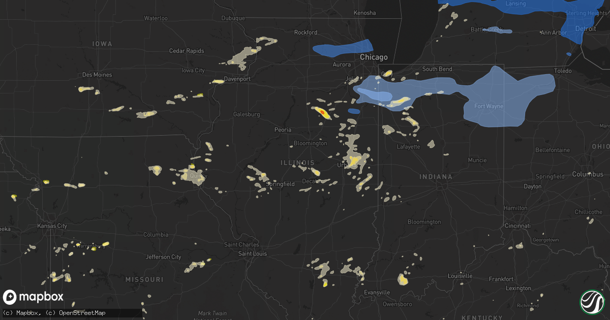
Hail Map in Illinois on August 29, 2022
Get this storm
August 29 map
$229
one time, instant access
Download today. No call, no setup
Keep the $229
Bought the map and want the full workflow? Apply the entire $229 to a subscription within 7 days. None of it is wasted.
Every map, not just this one
This buys you this map. Subscription and you get every map we run, in the markets you choose from a few cities to whole states to nationwide. Plus real-time alerts the moment a storm fires.
Contact data
Name, contact info, occupancy, even credit band for addresses in the footprint. You go from where it hit to who to call.
Become the source they trust
Unlimited branding weather history reports on demand. You already have the documented answer ready for the property owner, and you are the one who showed up with it.
Property data and RoofTrace estimates
Pull up any address you have got, its value and the exact code rules for that jurisdiction, straight from One Click Code. Then RoofTrace estimates the squares, pitch, and roof value, priced the way you price.
Storm reports in Illinois
Illinois
| Date | Description |
|---|---|
| 08/29/20226:30 PM CDT | Delayed report. Tree down over rte 97. |
| 08/29/20226:25 PM CDT | Media relayed photo of hailstone and reference quarter for size. |
| 08/29/20221:33 PM CDT | 20 foot tall... 6 inch diameter apple tree downed near bull creek road and il-17. East of grant park. Time estimated by radar. Relayed via amateur radio. |
| 08/29/20221:33 PM CDT | Tree downed and several branches downed on a farm near clifton. Location approximate. Time estimated by radar. Relayed via broadcast media. |
| 08/29/20221:30 PM CDT | T |
| 08/29/20221:30 PM CDT | Trained spotter reports small branches downed north of grant park near il-1 and 10500 north road. Relayed via amateur radio. Time estimated by radar. |
| 08/29/20221:30 PM CDT | 6-8 inch diameter branch downed in grant park near maple street and taylor street. Time estimated by radar. Relayed via social media. |
| 08/29/20221:30 PM CDT | Power poles downed and debris on roadways near 6000 north road and 7500 east road west of grant park. Time estimated by radar. |
| 08/29/20221:30 PM CDT | Several reports of downed trees in grant park... Aroma park... Bradley... And kankakee. Time estimated by radar. |
| 08/29/20221:25 PM CDT | 2 foot diameter tree downed blocking a road. Tree appears to be rotted. Another 12 inch branch downed onto car. Relayed via social media. Time estimated by radar. |
| 08/29/20221:24 PM CDT | Private weather station reported 74 mph gust east of peotone. |
| 08/29/20221:24 PM CDT | Peotone cooperative observer reports 69 mph gust near 3rd street and main street. Mesonet station located 35 feet above ground level on police station. Observer also re |
| 08/29/20221:20 PM CDT | 9 inch diameter branch downed near corning avenue and conrad street in peotone. Relayed via amateur radio. Time estimated by radar. |
| 08/29/20221:20 PM CDT | Trained spotter reports widespread damage to trees on the northwest side of peotone. Most trees with downed branches and limbs. Time estimated by radar. |
| 08/29/20221:18 PM CDT | Large tree branches downed near i-57 and wilmington peotone road west of peotone. Time estimated by radar. |
| 08/29/20221:18 PM CDT | Public report of 6 inch diameter tree limbs downed near county line road and us 45 us 52. Time estimated by radar. |
| 08/29/20221:17 PM CDT | Photos shared on social media of several 6-8 inch in diameter tree branches downed. Time estimated by radar. |
| 08/29/20221:15 PM CDT | Public report of small branches downed northwest of bourbonnais. Relayed via mping. Time estimated by radar. |
| 08/29/20221:12 PM CDT | Multiple branches up to5-6 inch diameter downed in wilton center. Time estimated by radar. |
| 08/29/20221:10 PM CDT | Emergency manager reports a few small branches downed in manhattan and a downed power line. Time estimated by radar. |
| 08/29/20221:05 PM CDT | Approximately 20 medium to large sized trees downed within midewin... In particular along iron bridge trailhead. Time estimated by radar. |
| 08/29/20221:05 PM CDT | Multiple large trees downed along midewin iron bridge trailhead. Time estimated by radar. |
| 08/29/20221:05 PM CDT | Braidwood emergency management reports multiple large tree branches downed. Time estimated by radar. |
| 08/29/20221:02 PM CDT | Photo shared via social media shows semi trailer tipped over at industrial parking lot. Location approximate. Time estimated by radar. |
| 08/29/20221:00 PM CDT | Public report of small branches downed in dwight. Relayed via mping. Time estimated by radar. |
| 08/29/202212:51 PM CDT | 911 call center relayed a large tree branch was downed and blocked both directions of sand ridge road. Time estimated by radar. |
| 08/29/202212:50 PM CDT | Multiple public reports of tree limbs downed in the greater grand crossing community area of chicago. Relayed via chicago 311. Time estimated by radar. |
| 08/29/202212:49 PM CDT | Multiple public reports of tree limbs downed in the washington heights... Beverly... And morgan park community areas of chicago. Relayed via chicago 311. Time estimated |
| 08/29/202212:45 PM CDT | Picture of tree branches down on a car in the 7000 block of washtenaw avenue. Report relayed via social media. |
| 08/29/202212:45 PM CDT | Corrects previous tstm wnd dmg report from chicago lawn. Picture of tree branches down on a car in the 7000 block of north washtenaw avenue. Report relayed via social m |
| 08/29/202212:45 PM CDT | Multiple public reports of tree limbs downed in the new city and englewood community areas of chicago. Relayed via chicago 311. Time estimated by radar. |
| 08/29/202212:44 PM CDT | Report of a fence damaged by downed tree branches. Time estimated by radar. |
| 08/29/202212:36 PM CDT | Four inch diameter branch downed on car. Time estimated by radar. |
| 08/29/202212:35 PM CDT | Multiple public reports of tree limbs downed in the west ridge and lincoln square community areas of chicago. Relayed via chicago 311. Time estimated by radar. |
| 08/29/202212:35 PM CDT | Public report of 8 inch tree limbs downed and damage to a screen door. Relayed via social media. Time estimated by radar. |
| 08/29/202212:35 PM CDT | Public report of multiple downed large branches and small trees in evanston. Relayed via social media. Time estimated by radar. |
| 08/29/202212:35 PM CDT | Public report of small tree downed in evanston. Relayed via social media. Time estimated by radar. |
| 08/29/202212:34 PM CDT | Multiple public reports of tree limbs downed in the irving park community area of chicago. Relayed via chicago 311. Time estimated by radar. |
| 08/29/202212:34 PM CDT | Multiple public reports of tree limbs downed in the west town community area of chicago. Relayed via chicago 311. Time estimated by radar. |
| 08/29/202212:33 PM CDT | Multiple public reports of tree limbs downed in the albany park community area of chicago. Relayed via chicago 311. Time estimated by radar. |
| 08/29/202212:33 PM CDT | Multiple public reports of tree limbs downed in the humboldt park community area of chicago. Relayed via chicago 311. Time estimated by radar. |
| 08/29/202212:32 PM CDT | Multiple public reports of tree limbs downed in the north park community area of chicago. Relayed via chicago 311. Time estimated by radar. |
| 08/29/202212:31 PM CDT | Multiple public reports of tree limbs downed in the belmont cragin community area of chicago. Relayed via chicago 311. Time estimated by radar. |
| 08/29/202212:31 PM CDT | Multiple public reports of tree limbs downed in northern sections of the austin community area of chicago. Relayed via chicago 311. Time estimated by radar. |
| 08/29/202212:30 PM CDT | Us army corps of engineers weather station reported 62 mph gust. |
| 08/29/202212:30 PM CDT | Partially uprooted tree onto power lines. |
| 08/29/202212:30 PM CDT | Report of multiple trees and power lines damaged in streator. Time estimated by radar. Relayed via broadcast media. |
| 08/29/202212:30 PM CDT | Multiple public reports of tree limbs downed in the jefferson park community area of chicago. Relayed via chicago 311. Time estimated by radar. |
| 08/29/202212:30 PM CDT | Multiple public reports of tree limbs downed in the dunning and montclare community area of chicago. Relayed via chicago 311. Time estimated by radar. |
| 08/29/202212:28 PM CDT | Multiple public reports of tree limbs downed in the norwood park community area of chicago. Relayed via chicago 311. Time estimated by radar. |
| 08/29/202212:28 PM CDT | Multiple large trees downed... Including one down on a car. |
| 08/29/202212:28 PM CDT | Report of tree branches downed across ottawa. Also a large tree snapped and roots and leaning on a bent power pole. Time estimated by radar. |
| 08/29/202212:28 PM CDT | Report of tree branches downed across ottawa. Time estimated by radar. |
| 08/29/202212:28 PM CDT | Large tree branches down. Relayed via social media. Time estimated by radar. |
| 08/29/202212:28 PM CDT | Report of a tree branch falling on a home in the 700 block of south monroe street. Relayed via emergency management. Time estimated from radar. |
| 08/29/202212:28 PM CDT | Multiple public reports of tree limbs downed in the edison park community area of chicago. Relayed via chicago 311. Time estimated by radar. |
| 08/29/202212:28 PM CDT | Tree down on car. |
| 08/29/202212:26 PM CDT | Large tree branch on power lines by canfield and talcott. Relayed on social media. |
| 08/29/202212:26 PM CDT | Downed at rand road and golf road. Relayed on social media. |
| 08/29/202212:25 PM CDT | Public report of healthy tree 12 inches in diameter snapped at the base. Time estimated by radar. |
| 08/29/202212:24 PM CDT | Multiple large branches broken at the olivet nazarene university campus. Time estimated by radar. |
| 08/29/202212:22 PM CDT | Public report of 18 inch diameter tree snapped at base. Tree appeared to be rotten. Time estimated by radar. |
| 08/29/202212:21 PM CDT | Multiple downed branches about one to one and a half inches in diameter along euclid road. Relayed via social media. |
| 08/29/202212:20 PM CDT | Public report of 6-8 inch diameter branches downed. Time estimated by radar. |
| 08/29/202212:20 PM CDT | Multiple branches up to 6 inch diameter downed in mount prospect including at least one on a vehicle and another on power lines. Relayed via social media. Time estimate |
| 08/29/202212:20 PM CDT | Multiple branches up to 6 inch diameter downed in mount prospect. Relayed via social media. Time estimated by radar. |
| 08/29/202212:15 PM CDT | Large tree limb down on kerwood st. Time estimated by radar. |
| 08/29/202212:14 PM CDT | 60 mph gust recorded by hoffman estates emergency management. |
| 08/29/202212:12 PM CDT | 6 inch diameter branch downed onto fence near north avenue and glen ellyn road. Time estimated by radar. |
| 08/29/202212:10 PM CDT | Tree down on hickory grove road. |
| 08/29/202212:08 PM CDT | Trained spotter reports 1/2 inch to 2 inch diameter tree branches downed near butterfield road and il-59. Time estimated by radar. |
| 08/29/202212:06 PM CDT | Large tree branches and snapped trees and branches on power lines. National street & villa street area had the most damage. Relayed on social media. |
| 08/29/202212:05 PM CDT | Multiple reports of small tree branches downed in elgin area relayed via mping. Time estimated by radar. |
| 08/29/202212:04 PM CDT | Webcam caught a large tree being blown over along the fox river. Relayed via social media. Time estimated by radar. |
| 08/29/202211:56 AM CDT | Delayed report and time estimated from radar. Large tree knocked down in yard. |
| 08/29/202211:43 AM CDT | Medium sized branches down. Relayed via social media. Time estimated by radar. |
| 08/29/20227:19 AM CDT | At 1218 PM CDT, severe thunderstorms were located along a line extending from near Earlville to near North Utica, moving east at 45 mph. HAZARD...60 mph wind gusts and nickel size hail. SOURCE...Radar indicated. IMPACT...Expect damage to roofs, siding, and trees. Locations impacted include... Ottawa, Yorkville, Morris, Peru, La Salle, Mendota, Marseilles, Sheridan, Lake Holiday, Seneca, Somonauk, Earlville, North Utica, Serena, Newark, Leland, Naplate, Millington, Dayton and Millbrook.Including the following interstates... I-39 between mile markers 57 and 77. I-80 between mile markers 74 and 114.This includes... Buffalo Rock State Park, Gebhard Woods State Park,Grundy County Speedway and Fairgrounds, Illini State Park, Tri-CountyFairgrounds, and William G Stratton State Park. |
| 08/29/20227:14 AM CDT | At 1214 PM CDT, severe thunderstorms were located along a line extending from Inverness to Addison to near Lisle, moving east at 55 mph. HAZARD...60 mph wind gusts. SOURCE...Radar indicated. IMPACT...Expect damage to roofs, siding, and trees. Locations impacted include... Chicago, Cicero, Arlington Heights, Evanston, Palatine, Skokie, Des Plaines, Berwyn, Mount Prospect, Oak Park, Glenview, Elmhurst, Lombard, Buffalo Grove, Ohare Airport, Wheeling, Park Ridge, Addison, Northbrook and Elk Grove Village.This includes... Lincoln Park Zoo, Loyola University, OaktonCommunity College, Triton College, Hawthorne Park, NortheasternIllinois University, Northwestern University, Ravinia Music Festival,Soldier Field, University of Illinois Chicago, Wrigley Field, TheLoop, Museum Campus, and Northerly Island. |
| 08/29/20227:02 AM CDT | At 1202 PM CDT, severe thunderstorms were located along a line extending from Spring Valley to near Sparland, moving southeast at 45 mph. HAZARD...60 mph wind gusts and nickel size hail. SOURCE...Radar indicated. IMPACT...Expect damage to roofs, siding, and trees. Locations impacted include... Ottawa, Streator, Pontiac, Peru, La Salle, Marseilles, Spring Valley, Oglesby, Seneca, Gridley, North Utica, Flanagan, Wenona, Odell, South Streator, Tonica, Grand Ridge, Cornell, Lostant and Ransom.Including the following interstates... I-39 between mile markers 41 and 56. I-55 between mile markers 189 and 213.This includes... Buffalo Rock State Park, Illini State Park,Illinois Valley Community College, Matthiessen State Park, andStarved Rock State Park. |
| 08/29/20226:58 AM CDT | At 1157 AM CDT, a severe thunderstorm was located near Henry, or 7 miles southwest of Hennepin, moving east at 55 mph. HAZARD...60 mph wind gusts and penny size hail. SOURCE...Radar indicated. IMPACT...Expect damage to roofs, siding, and trees. This severe thunderstorm will be near... Varna around 1210 PM CDT.Other locations in the path of this severe thunderstorm includeWenona.This includes Interstate 39 between mile markers 30 and 40. |
| 08/29/20226:53 AM CDT | At 1153 AM CDT, a severe thunderstorm was located near Putnam, or near Hennepin, moving east at 60 mph. HAZARD...60 mph wind gusts and penny size hail. SOURCE...Radar indicated. IMPACT...Expect damage to roofs, siding, and trees. This severe thunderstorm will be near... Granville and McNabb around 1200 PM CDT. Magnolia and Standard around 1205 PM CDT. |
| 08/29/20226:40 AM CDT | At 1139 AM CDT, severe thunderstorms were located along a line extending from near Genoa to near Cortland to near Waterman, moving east at 45 mph. HAZARD...60 mph wind gusts and penny size hail. SOURCE...Radar indicated. IMPACT...Expect damage to roofs, siding, and trees. Locations impacted include... Aurora, Naperville, Elgin, Schaumburg, Bolingbrook, Palatine, Wheaton, Hoffman Estates, Downers Grove, DeKalb, Lombard, Bartlett, Streamwood, Carol Stream, Romeoville, Hanover Park, Carpentersville, Addison, Glendale Heights and Elk Grove Village.Including the following interstates... I-55 between mile markers 265 and 269. I-88 between mile markers 88 and 132. I-90 between mile markers 42 and 68. I-290 between mile markers 1 and 3. I-355 between mile markers 11 and 21, and between mile markers 24and 30.This includes... Northern Illinois University, Schaumburg BoomersBaseball, Aurora University, Benedictine University, College ofDuPage, DuPage County Fairgrounds, Elgin Community College, Fermilab,Harper College, IL Math and Science Academy, Kane County CougarsBallpark, Morton Arboretum, Waubonsee Community College, and WheatonCollege. |
| 08/29/20225:13 AM CDT | At 1013 AM CDT, severe thunderstorms were located along a line extending from Muscatine Municipal Airport to Yarmouth, moving east at 40 mph. HAZARD...60 mph wind gusts and quarter size hail. SOURCE...Radar indicated. IMPACT...Hail damage to vehicles is expected. Expect wind damage to roofs, siding, and trees. Locations impacted include... Muscatine, Aledo, Wapello, Columbus Junction, Fruitland, Morning Sun, Millersburg, New Boston, Keithsburg, Grandview, Reynolds, Eliza, Joy, Columbus City, Letts, Seaton, Oakville, Hamlet, Amber and Toolesboro. |
| 08/29/20223:59 AM CDT | At 858 PM CDT, severe thunderstorms were located over mainly rural areas of Coles, Edgar, and Douglas Counties, moving southeast at 35 mph. HAZARD...60 mph wind gusts and penny size hail. SOURCE...Public. IMPACT...Expect damage to roofs, siding, and trees. Severe thunderstorms will be near... Chrisman around 905 PM CDT. |
| 08/29/20223:28 AM CDT | At 828 PM CDT, severe thunderstorms were located along a line extending from near Atwood to near Arthur to near Bethany, moving east at 35 mph. HAZARD...60 mph wind gusts and penny size hail. SOURCE...Radar indicated. IMPACT...Expect damage to roofs, siding, and trees. Severe thunderstorms will be near... Arthur around 835 PM CDT. Humboldt around 845 PM CDT.Other locations in the path of these severe thunderstorms includeMattoon, Cooks Mill, Charleston, Oakland and Rardin.This includes Interstate 57 between mile markers 188 and 201. |
| 08/29/20223:17 AM CDT | At 816 PM CDT, severe thunderstorms were located along a line extending from Pesotum to near Tuscola to near Arthur, moving east at 40 mph. HAZARD...60 mph wind gusts and nickel size hail. SOURCE...Radar indicated. IMPACT...Expect damage to roofs, siding, and trees. Severe thunderstorms will be near... Tuscola around 825 PM CDT. Arcola and Villa Grove around 830 PM CDT. Camargo around 835 PM CDT.Other locations in the path of these severe thunderstorms includeHindsboro and Newman.This includes Interstate 57 between mile markers 202 and 217. |
| 08/29/20223:15 AM CDT | At 815 PM CDT, severe thunderstorms were located along a line extending from near Ogden to near Sidney, moving east at 15 mph. HAZARD...60 mph wind gusts and penny size hail. SOURCE...Radar indicated. IMPACT...Expect damage to roofs, siding, and trees. Severe thunderstorms will be near... Ogden around 820 PM CDT. Fithian around 830 PM CDT. Muncie around 835 PM CDT.Other locations in the path of these severe thunderstorms includeHomer, Allerton, Oakwood, Catlin, Fairmount, Danville, Westville,Tilton, Sidell and Belgium.This includes Interstate 74 between mile markers 190 and 220. |
| 08/29/20222:52 AM CDT | At 751 PM CDT, a severe thunderstorm was located over mainly rural areas of eastern Macon county moving southeast at 25 mph. HAZARD...60 mph wind gusts and half dollar size hail. SOURCE...Radar indicated. IMPACT...Hail damage to vehicles is expected. Expect wind damage to roofs, siding, and trees. This severe thunderstorm will be near... Bement around 805 PM CDT.Other locations in the path of this severe thunderstorm includeHammond and Lovington.This includes Interstate 72 between mile markers 145 and 157. |
| 08/29/20222:47 AM CDT | At 747 PM CDT, a severe thunderstorm was located near Hannibal, moving southeast at 20 mph. HAZARD...60 mph wind gusts and penny size hail. SOURCE...Radar indicated. IMPACT...Expect damage to roofs, siding, and trees. This severe thunderstorm will be near... Hannibal around 750 PM CDT. Fall Creek around 755 PM CDT.Other locations in the path of this severe thunderstorm include NewLondon.This includes the following highways... Interstate 172 between exits 2 and 10. Interstate 72 between exits 4 and 10. |
| 08/29/20222:31 AM CDT | At 731 PM CDT, a severe thunderstorm was located over mainly rural areas of Dewitt and Macon counties moving southeast at 15 mph. HAZARD...60 mph wind gusts and quarter size hail. SOURCE...Radar indicated. IMPACT...Hail damage to vehicles is expected. Expect wind damage to roofs, siding, and trees. This severe thunderstorm will be near... Oreana around 735 PM CDT. Argenta around 745 PM CDT.Other locations in the path of this severe thunderstorm include CerroGordo.This includes Interstate 72 between mile markers 145 and 160. |
| 08/29/20222:08 AM CDT | At 708 PM CDT, a severe thunderstorm was located over Cornell, or 8 miles northwest of Pontiac, moving southeast at 20 mph. HAZARD...60 mph wind gusts and quarter size hail. SOURCE...Radar indicated. IMPACT...Hail damage to vehicles is expected. Expect wind damage to roofs, siding, and trees. Locations impacted include... Pontiac, Odell, Cornell, Saunemin and Emington. Including the following interstate... I-55 between mile markers 193 and 211. |
| 08/29/20221:57 AM CDT | At 656 PM CDT, severe thunderstorms were located along a line extending from Camp Point to near Maywood to near Steffenville to 9 miles northeast of Atlanta, moving southeast at 20 mph. HAZARD...60 mph wind gusts and quarter size hail. SOURCE...Radar indicated. IMPACT...Hail damage to vehicles is expected. Expect wind damage to roofs, siding, and trees. Severe thunderstorms will be near... Camp Point and Golden around 700 PM CDT. Maywood around 705 PM CDT. Clayton around 715 PM CDT.Other locations in the path of these severe thunderstorms includePalmyra, Emden, Philadelphia, Shelbyville and Fall Creek.This includes Interstate 172 between exits 2 and 19. This also includes Wakonda State Park and Siloam Springs State Park. |
| 08/29/20221:56 AM CDT | At 655 PM CDT, severe thunderstorms were located over mainly rural areas of Morgan, Menard, Sangamon, and Cass counties moving southeast at 15 mph. HAZARD...60 mph wind gusts and nickel size hail. SOURCE...Radar indicated. IMPACT...Expect damage to roofs, siding, and trees. Severe thunderstorms will be near... Sherman around 700 PM CDT. Riverton around 715 PM CDT.Other locations in the path of these severe thunderstorms includeRochester, Chatham, Auburn and Springfield.This includes the following highways... Interstate 55 between mile markers 83 and 107. Interstate 72 between mile markers 76 and 113. |
| 08/29/20221:34 AM CDT | At 633 PM CDT, a severe thunderstorm was located near Streator, moving east at 25 mph. HAZARD...60 mph wind gusts and quarter size hail. SOURCE...Radar indicated. IMPACT...Hail damage to vehicles is expected. Expect wind damage to roofs, siding, and trees. Locations impacted include... Streator, Pontiac, Odell, South Streator, Cornell, Ransom, Kangley, Long Point and Dana.Including the following interstate... I-55 between mile markers 198 and 210. |
| 08/29/20221:15 AM CDT | At 615 PM CDT, a severe thunderstorm was located over Stillwell, or 14 miles south of Carthage, moving east at 10 mph. HAZARD...60 mph wind gusts and half dollar size hail. SOURCE...Radar indicated. IMPACT...Hail damage to vehicles is expected. Expect wind damage to roofs, siding, and trees. This severe thunderstorm will be near... West Point and Stillwell around 620 PM CDT.Other locations in the path of this severe thunderstorm includeBowen. |
| 08/29/20221:13 AM CDT | At 612 PM CDT, severe thunderstorms were located along a line extending from near West Point to near La Grange to near Ewing, moving southeast at 15 mph. HAZARD...60 mph wind gusts and half dollar size hail. SOURCE...Trained weather spotters. Half dollar size hail was reported near Canton at 606 pm CDT. IMPACT...Hail damage to vehicles is expected. Expect wind damage to roofs, siding, and trees. Locations impacted include... Mendon, Camp Point, Golden, Quincy, Quincy Regional Airport and Clayton.This includes Interstate 172 between exits 14 and 19. This also includes Wakonda State Park. |
| 08/29/20221:11 AM CDT | At 610 PM CDT, severe thunderstorms were located over mainly rural areas of Cass, Morgan, Menard, and Sangamon counties moving east at 20 mph. HAZARD...60 mph wind gusts and penny size hail. SOURCE...Radar indicated. IMPACT...Expect damage to roofs, siding, and trees. Severe thunderstorms will be near... Athens around 620 PM CDT.Other locations in the path of these severe thunderstorms includeSherman.This includes Interstate 72 between mile markers 81 and 97. |
| 08/29/20221:08 AM CDT | At 608 PM CDT, a severe thunderstorm was located near Delta, moving northeast at 15 mph. HAZARD...60 mph wind gusts and half dollar size hail. SOURCE...Radar indicated. IMPACT...Hail damage to vehicles is expected. Expect wind damage to roofs, siding, and trees. This severe thunderstorm will be near... Dutchtown around 625 PM CDT.Other locations in the path of this severe thunderstorm includeGordonville, Cape Girardeau Airport, Scott City, Cape Girardeau andJackson.This includes Interstate 55 between Mile Markers 91 and 104. |
| 08/29/20221:02 AM CDT | At 602 PM CDT, a severe thunderstorm was located near Helm, or 14 miles northeast of Mount Vernon, moving east at 25 mph. HAZARD...60 mph wind gusts and penny size hail. SOURCE...Radar indicated. IMPACT...Expect damage to roofs, siding, and trees. This severe thunderstorm will be near... Wayne City around 610 PM CDT.Other locations in the path of this severe thunderstorm includeCisne. |
| 08/29/202212:04 AM CDT | At 504 PM CDT, a severe thunderstorm was located over Carthage, moving southeast at 15 mph. HAZARD...60 mph wind gusts and quarter size hail. SOURCE...Radar indicated. IMPACT...Hail damage to vehicles is expected. Expect wind damage to roofs, siding, and trees. This severe thunderstorm will be near... Bentley around 520 PM CDT.Other locations in the path of this severe thunderstorm includeDenver, Augusta, Bowen, Plymouth and Hancock County Fairgrounds. |
| 08/28/202211:49 PM CDT | At 449 PM CDT, a severe thunderstorm was located over Argyle Lake State Park, or near Macomb, moving east at 10 mph. HAZARD...60 mph wind gusts and quarter size hail. SOURCE...Radar indicated. IMPACT...Hail damage to vehicles is expected. Expect wind damage to roofs, siding, and trees. This severe thunderstorm will be near... McDonough County 4-H Grounds and Spring Lake around 505 PM CDT.Other locations in the path of this severe thunderstorm includeWestern Illinois University, Macomb and Macomb Municipal Airport. |
| 08/28/202211:20 PM CDT | At 420 PM CDT, a severe thunderstorm was located over Adrian, or near Carthage, moving east at 35 mph. HAZARD...60 mph wind gusts and quarter size hail. SOURCE...Radar indicated. IMPACT...Hail damage to vehicles is expected. Expect wind damage to roofs, siding, and trees. This severe thunderstorm will be near... Carthage around 425 PM CDT. Burnside around 430 PM CDT. La Harpe, Fountain Green and Webster around 440 PM CDT.Other locations in the path of this severe thunderstorm includeBlandinsville, Colchester, Tennessee, Macomb, Sciota, Spring Lake andArgyle Lake State Park. |
| 08/28/20229:32 PM CDT | A local report indicates 74 MPH wind near 1 S ALLENVILLE |
| 08/28/20228:41 PM CDT | At 140 PM CDT, severe thunderstorms were located along a line extending from near Gilman to 7 miles south of Piper City to near Gibson City, moving southeast at 35 mph. HAZARD...60 mph wind gusts and quarter size hail. SOURCE...Radar indicated. IMPACT...Hail damage to vehicles is expected. Expect wind damage to roofs, siding, and trees. Locations impacted include... Watseka, Paxton, Gibson City, Gilman, Milford, Chatsworth, Onarga, Cissna Park, Piper City, Buckley, Stockland, Crescent City, Danforth, Melvin, Loda, Roberts, Woodland, Elliott, Sibley and Wellington.Including the following interstate... I-57 between mile markers 258 and 290. |
| 08/28/20228:29 PM CDT | At 129 PM CDT, severe thunderstorms were located along a line extending from Hammond to near Sauk Village, moving east at 55 mph. HAZARD...70 mph wind gusts and nickel size hail. SOURCE...Radar indicated. IMPACT...Expect considerable tree damage. Damage is likely to mobile homes, roofs, and outbuildings. Locations impacted include... Hammond, Gary, Portage, Merrillville, Valparaiso, East Chicago, Schererville, Hobart, Highland, Munster, Chesterton, Griffith, Dyer, St. John, Lake Station, Lynwood, South Haven, New Chicago and Wheeler.Including the following interstates... Indiana I-80 between mile markers 1 and 16. Indiana I-90 between mile markers 7 and 36. Indiana I-94 between mile markers 16 and 17. Indiana I-65 between mile markers 253 and 261.This includes... Indiana University Northwest, Purdue UniversityCalumet, Valparaiso University, Illiana Motor Speedway, and SouthShore Rail Cats Baseball. |
| 08/28/20227:55 PM CDT | Numerous tree limbs and power lines were blown down. A flag pole was bent. |
| 08/28/20227:45 PM CDT | Delayed report. Tree down on power lines in town. |
| 08/28/20227:45 PM CDT | Large tree branches and power lines were blown down. |
| 08/28/20227:45 PM CDT | Power lines down and tree down in argenta. |
| 08/28/20227:40 PM CDT | Trees down. |
| 08/28/20227:40 PM CDT | Tree damage and 0.75 inch hail reported in kickapoo state park. |
| 08/28/20227:39 PM CDT | Tree snapped. |
| 08/28/20227:39 PM CDT | Downed power pole/lines blocking roads. |
| 08/28/20227:35 PM CDT | Large tree branches and power lines were blown down. |
| 08/28/20227:35 PM CDT | Power poles down on poland rd in danville. |
| 08/28/20227:35 PM CDT | Large limbs down on denmark rd 2 nw of danville. |
| 08/28/20227:30 PM CDT | Power poles down and transformer on fire near the 1700 block of washington rd. |
| 08/28/20227:22 PM CDT | Trees down. |
| 08/28/20227:15 PM CDT | Video shows a trampoline blown over a 15 ft porch roof and landed in backyard from strong thunderstorm winds. Time estimated from radar. |
| 08/28/20227:12 PM CDT | A local report indicates 1.00 inch wind near CORNELL |
| 08/28/20227:12 PM CDT | Tree and power pole down and on fire near the 100 block of grant st. |
| 08/28/20227:04 PM CDT | Mesonet station dw9022 plainfield. |
| 08/28/20227:00 PM CDT | Relayed via broadcast media. Time estimated by radar. |
All States Impacted by Hail Map on August 29, 2022
Cities Impacted by Hail Map on August 29, 2022
- Watervliet, MI
- Allegan, MI
- Bloomingdale, MI
- Salem, WI
- Burlington, WI
- Indianola, IA
- Big Rapids, MI
- Dalton City, IL
- Montague, MI
- Whitehall, MI
- Chelsea, MI
- Oakland, IL
- Ridge Farm, IL
- Metcalf, IL
- Indianola, IL
- Brocton, IL
- Catlin, IL
- Georgetown, IL
- Hume, IL
- Chrisman, IL
- Newman, IL
- Fennville, MI
- Hamilton, MI
- Saugatuck, MI
- Holland, MI
- Douglas, MI
- Dana, IN
- Clinton, IN
- Hillsdale, IN
- Paris, IL
- Bennett, IA
- Ainsworth, IA
- Pontiac, IL
- Odell, IL
- Streator, IL
- Ancona, IL
- Wenona, IL
- Cornell, IL
- Long Point, IL
- Saunemin, IL
- Fisher, IL
- Mahomet, IL
- Franklin, IL
- New Berlin, IL
- Jacksonville, IL
- Alexander, IL
- Mansfield, IL
- Newark, MO
- Knox City, MO
- Decatur, IL
- Hammond, IL
- La Place, IL
- Cerro Gordo, IL
- Argenta, IL
- Elliott, IL
- Gibson City, IL
- Frankfort, KS
- Lincoln, IL
- Allerton, IL
- Broadlands, IL
- Fairfield, IL
- Clinton, MO
- Montrose, MO
- Grand Rapids, MI
- Grand Ridge, IL
- Gary, IN
- Lake Station, IN
- Seneca, IL
- Sharon, WI
- Clinton, WI
- Sibley, IL
- Beallsville, OH
- Curwensville, PA
- Clearfield, PA
- West Terre Haute, IN
- Newcomerstown, OH
- West Lafayette, OH
- Pembroke Township, IL
- Lansing, IL
- Chicago Heights, IL
- Glenwood, IL
- Munster, IN
- Highland, IN
- Monon, IN
- Delphi, IN
- Yeoman, IN
- Idaville, IN
- Monticello, IN
- Brookston, IN
- Leonard, MO
- Gibbs, MO
- Novelty, MO
- Hurdland, MO
- La Plata, MO
- Kentland, IN
- Earl Park, IN
- Fowler, IN
- Goodland, IN
- Remington, IN
- Wathena, KS
- Saint Joseph, MO
- Grand Junction, MI
- Washington, IA
- Clinton, IA
- Long Grove, IA
- McCausland, IA
- Calamus, IA
- Thomson, IL
- Bryant, IA
- Grand Mound, IA
- Charlotte, IA
- Savanna, IL
- Camanche, IA
- Preston, IA
- Eldridge, IA
- Welton, IA
- Princeton, IA
- Sabula, IA
- Miles, IA
- Delmar, IA
- De Witt, IA
- Goose Lake, IA
- Driftwood, PA
- Chatsworth, IL
- Melvin, IL
- Strawn, IL
- Beason, IL
- Everest, KS
- Lancaster, KS
- Horton, KS
- Effingham, KS
- Lone Jack, MO
- Loraine, IL
- West Point, IL
- Pleasant Hill, MO
- Kingsville, MO
- Gardner, KS
- Edgerton, KS
- Spring Hill, KS
- Gardner, IL
- Dwight, IL
- Manhattan, IL
- Elwood, IL
- Joliet, IL
- Mokena, IL
- Channahon, IL
- New Lenox, IL
- Sanford, MI
- Shepherd, MI
- Coleman, MI
- Midland, MI
- Shelbyville, MO
- Emden, MO
- Lake Village, IN
- Marne, MI
- Coopersville, MI
- Belmont, MI
- Zeeland, MI
- Rockford, MI
- Allendale, MI
- Comstock Park, MI
- Conklin, MI
- Sparta, MI
- West Olive, MI
- Waterford, WI
- Cooksville, IL
- Richland, IA
- Brighton, IA
- Warsaw, IL
- Basco, IL
- Carthage, IL
- North Judson, IN
- Demotte, IN
- Fair Oaks, IN
- Wheatfield, IN
- Rensselaer, IN
- San Pierre, IN
- Elsie, MI
- Brohman, MI
- Bitely, MI
- White Cloud, MI
- Paris, MI
- Reddick, IL
- Muscatine, IA
- Winterset, IA
- Plymouth, IN
- Bourbon, IN
- Argos, IN
- Carbon, IN
- Brazil, IN
- Hartford, MI
- Nunica, MI
- New Salem, IL
- Colchester, IL
- Wheatland, IA
- New Liberty, IA
- Morocco, IN
- Danville, IL
- Terre Haute, IN
- Lovington, IL
- Chenoa, IL
- Junction City, KS
- Murrayville, IL
- Paloma, IL
- Holden, MO
- Lakeville, OH
- Glenmont, OH
- Bethany, MO
- East Palestine, OH
- Montgomery, IN
- Cannelburg, IN
- Ashland, IL
- Herington, KS
- Offerle, KS
- Lewis, KS
- Kinsley, KS
- Valparaiso, IN
- Hobart, IN
- Tolono, IL
- Philo, IL
- Sidney, IL
- Savoy, IL
- Potomac, IL
- Saint Joseph, IL
- Rossville, IL
- Rantoul, IL
- Loda, IL
- Thomasboro, IL
- Buckley, IL
- Roberts, IL
- Paxton, IL
- Homer, IL
- Armstrong, IL
- Collison, IL
- Muncie, IL
- Urbana, IL
- Gifford, IL
- Ogden, IL
- Fairmount, IL
- Cissna Park, IL
- Champaign, IL
- Oakwood, IL
- Ludlow, IL
- Penfield, IL
- Fithian, IL
- Royal, IL
- Rankin, IL
- La Monte, MO
- Hughesville, MO
- Sedalia, MO
- Knob Noster, MO
- Pleasant Plains, IL
- Springfield, IL
- Hopedale, IL
- Minier, IL
- Barry, IL
- Genoa City, WI
- Lake Geneva, WI
- Peculiar, MO
- Columbus Junction, IA
- Crawfordsville, IA
- Columbus City, IA
- Wayland, IA
- Francesville, IN
- Winamac, IN
- Medaryville, IN
- Chillicothe, OH
- Waverly, OH
- Freeman, MO
- Stoutland, MO
- Richland, MO
- Ewing, IL
- McLeansboro, IL
- Macedonia, IL
- Dahlgren, IL
- Belle Rive, IL
- Plainwell, MI
- Otsego, MI
- Chariton, IA
- Lovilia, IA
- Russell, IA
- Melrose, IA
- Bonfield, IL
- La Porte, IN
- Minooka, IL
- Hamilton, IL
- Maroa, IL
- Virginia, IL
- Beardstown, IL
- Arenzville, IL
- Coshocton, OH
- Hamilton, MO
- Kidder, MO
- Cameron, MO
- Waverly, IL
- Chandlerville, IL
- Bath, IL
- Tallula, IL
- Loami, IL
- Marshfield, MO
- Strafford, MO
- Packwood, IA
- Fairfield, IA
- Tipton, IN
- Beloit, KS
- Mount Carroll, IL
- Lanark, IL
- Shannon, IL
- Hoisington, KS
- Olmitz, KS
- Norwalk, IA
- Saint Charles, IA
- Prole, IA
- Patterson, IA
- Martensdale, IA
- Bevington, IA
- Dexter, MO
- Bloomfield, MO
- Dixon, IA
- Cosby, MO
- Easton, MO
- Ensign, KS
- Niangua, MO
- Columbus, OH
- Culver, IN
- Knox, IN
- Pittsfield, IL
- Sullivan, IL
- Beecher, IL
- Walkerville, MI
- Hesperia, MI
- Westville, IN
- Crete, IL
- Saint John, IN
- Dyer, IN
- Piper City, IL
- Gilman, IL
- Ashkum, IL
- Danforth, IL
- Kempton, IL
- Blakesburg, IA
- Ottumwa, IA
- Drakesville, IA
- Albia, IA
- Bloomfield, IA
- Moravia, IA
- Agency, IA
- Unionville, IA
- Barnard, KS
- Seymour, MO
- Bethesda, OH
- Iuka, IL
- Dix, IL
- Walnut Hill, IL
- Kell, IL
- Dodge City, KS
- Circleville, OH
- Ramona, KS
- Hope, KS
- Joelton, TN
- Goodlettsville, TN
- Whites Creek, TN
- Jeffersonville, IN
- Yukon, OK
- Wayne City, IL
- Burkesville, KY
- Norman, OK
- Huntingburg, IN
- Verden, OK
- Chickasha, OK
- Spearville, KS
- Richmond, KY
- Louisville, KY
- Fairdale, KY
- Fort Sumner, NM
- Pond Creek, OK
- Kremlin, OK
- Big Clifty, KY
- Pawnee, OK
- Amarillo, TX
- Geary, OK
- Calumet, OK
- Broseley, MO
- Melbourne, AR
- Sage, AR
- Ozark, AR
- Cleveland, OK
- Stillwater, OK
- Coyle, OK
- Perkins, OK
- Cache, OK
- Indiahoma, OK
- Skiatook, OK
- Fort Cobb, OK
- Barnsdall, OK
- Milnesand, NM
- Morton, TX
- Tatum, NM
- Tulia, TX
- Mustang, OK
- Gotebo, OK
- Mountain View, OK
- Elida, NM
- Abernathy, TX
- Happy, TX
- Weir, KS
- Anson, TX
- Reeds Spring, MO
- Whiteface, TX
- Pecos, TX
- Childress, TX
- Matador, TX
- Otis, KS
- Bison, KS
- Alexander, KS
- Bazine, KS
- Chaffee, MO
- Lockney, TX
- Floydada, TX
- Loving, NM
- Idalou, TX
- Petersburg, TX
- Apache, OK
- Quincy, IL
- Ellsworth, KS
- Kanopolis, KS
- Meade, KS
- Plains, KS
- Turpin, OK
- Forgan, OK
- Kismet, KS
- Anton, TX
- Levelland, TX
- Great Bend, KS
- Ewing, MO
- Maljamar, NM
- Lovington, NM
- Muleshoe, TX
- Sudan, TX
- Earth, TX
- Oran, MO
- Advance, MO
- Whitewater, MO
- Cape Girardeau, MO
- Booker, TX
- Nixa, MO
- Clever, MO
- Vinson, OK
- Seminole, OK
- Prague, OK
- Nazareth, TX
- Hart, TX
- Dimmitt, TX
- Ropesville, TX
- Meadow, TX
- Lorenzo, TX
- Tokio, TX
- Plains, TX
- Denver City, TX
- Crowell, TX
- Vernon, TX
- La Crosse, KS
- Bland, MO
- Balko, OK
- La Grange, MO
- Monticello, MO
- Lewistown, MO
- Canton, MO
- Payson, IL
- Taylor, MO
- Maywood, MO
- Palmyra, MO
- Durham, MO
- Philadelphia, MO
- Flomot, TX
- Wright, KS
- Odell, TX
- Capitan, NM
- Nekoma, KS
- Ness City, KS
- Albert, KS
- Winchester, KY
- Irvine, KY
- Amoret, MO
- Warrensburg, MO
- Billings, MO
- Republic, MO
- Enid, OK
- Hominy, OK
- Silverton, TX
- Blanchard, OK
- Amber, OK
- Owasso, OK
- Collinsville, OK
- Claremore, OK
- Jerico Springs, MO
- Lamar, MO
- Sheldon, MO
- Stockton, MO
- Ada, OK
- Canyon, TX
- Claude, TX
- Longview, IL
- Sutter, IL
- Lawton, OK
- Glencoe, OK
- Rosedale, IN
- Anadarko, OK
- Gracemont, OK
- Lebanon, MO
- Spearman, TX
- Kress, TX
- Plainview, TX
- Hamlin, TX
- Tecumseh, OK
- Shawnee, OK
- Linden, TN
- Wilson, KS
- Mulhall, OK
- Rogers, NM
- Eskridge, KS
- Paxico, KS
- Alma, KS
- Dumas, TX
- Sunray, TX
- Brownfield, TX
- Perryton, TX
- Oreana, IL
- Crosbyton, TX
- Frederick, OK
- Garden City, MO
- Dale, IN
- Lincoln City, IN
- Gentryville, IN
- Santa Claus, IN
- Holland, IN
- Ferdinand, IN
- Hoopeston, IL
- Blue Mound, IL
- Moweaqua, IL
- Macon, IL
- Stonington, IL
- Stratford, TX
- Wellsville, KS
- Rule, TX
- Owensville, IN
- Poseyville, IN
- Griffin, IN
- Mount Carmel, IL
- New Harmony, IN
- Dorrance, KS
- Bunker Hill, KS
- Ford, KS
- Hanston, KS
- Harrisonville, MO
- Johnsonville, IL
- Bluford, IL
- Sims, IL
- Mount Vernon, IL
- Opdyke, IL
- Keenes, IL
- Elgin, OK
- Jal, NM
- Paducah, TX
- Old Glory, TX
- Hobbs, NM
- Bethel, MO
- La Belle, MO
- El Dorado Springs, MO
- Milo, MO
- Scammon, KS
- Charleston, MO
- Mountain Grove, MO
- Berea, KY
- Waco, KY
- Vinita, OK
- Lindsay, OK
- Purcell, OK
- Centerville, TN
- Earlsboro, OK
- Lexington, OK
- Noble, OK
- Washington, OK
- Van Horn, TX
- Latham, IL
- Chestnut, IL
- Kenney, IL
- Cross Plains, IN
- Dubois, IN
- Butler, MO
- Walnut, KS
- Ribera, NM
- Eldorado, OK
- Elmer, OK
- Norwich, OH
- Graymont, IL
- Jetmore, KS
- Temple, OK
- Marble Hill, MO
- Claflin, KS
- Greensburg, KS
- Watonga, OK
- Emporia, KS
- Saint Anthony, IN
- Madison, IN
- Nowata, OK
- Hartville, MO
- Foster, MO
- Amsterdam, MO
- Omaha, AR
- Hollister, MO
- Stendal, IN
- Lamar, IN
- Sierra Blanca, TX
- Dalhart, TX
- Ellington, MO
- Hitchcock, OK
- Sweetwater, TX
- Panhandle, TX
- Springdale, AR
- Fayetteville, AR
- Tinnie, NM
- Fort Hancock, TX
- Paint Rock, TX
- Russellville, AL
- Tuscumbia, AL
- Orlando, OK
- Crescent, OK
- Guthrie, OK
- Farwell, TX
- Cedarbluff, MS
- Littlefield, TX
- Lubbock, TX
- Spur, TX
- Tell, TX
- Gallatin, MO
- Terlton, OK
- Rush Center, KS
- Golden Gate, IL
- Ellery, IL
- Albion, IL
- Gruver, TX
- Wanette, OK
- Salt Flat, TX
- Mentone, TX
- Post, TX
- Amherst, TX
- Weed, NM
- Gerald, MO
- Rosebud, MO
- Ottawa, KS
- Chilhowee, MO
- French Lick, IN
- West Baden Springs, IN
- Jasper, IN
- Adamsville, OH
- Centerview, MO
- Atwood, IL
- Pawnee Rock, KS
- Keota, OK
- Laredo, MO
- Chula, MO
- Alex, OK
- Oronogo, MO
- Liberal, MO
- Rozel, KS
- Omega, OK
- Hamersville, OH
- Bethel, OH
- Hurricane Mills, TN
- Waverly, TN
- Oklahoma City, OK
- Alton, MO
- Elkins, AR
- Paden, OK
- Mcloud, OK
- Newalla, OK
- Faxon, OK
- Whiteman Air Force Base, MO
- Ralls, TX
- Crane, MO
- Bartlesville, OK
- Pawhuska, OK
- Clay City, KY
- Olton, TX
- Maple, TX
- New Haven, MO
- Leslie, MO
- Gail, TX
- Roscoe, TX
- De Mossville, KY
- Falmouth, KY
- Perry, OK
- Mount Erie, IL
- West Salem, IL
- Eminence, MO
- Aurora, MO
- Prescott, KS
- Pleasanton, KS
- Mound City, KS
- Jeffersonville, KY
- Fowler, KS
- Louisa, KY
- Fort Sill, OK
- Shell Knob, MO
- Kimberling City, MO
- Aberdeen, MS
- Breckenridge, MO
- Dry Ridge, KY
- Willisburg, KY
- Blue Rapids, KS
- Golconda, IL
- Lerna, IL
- Belle, MO
- Owensville, MO
- Williamstown, KY
- Morning View, KY
- Butler, KY
- Crittenden, KY
- Hampton, KY
- Smithland, KY
- Grovespring, MO
- Grand Rivers, KY
- Goreville, IL
- Maple Hill, KS
- Foster, WV
- Danville, WV
- Julian, WV
- Chapmanville, WV
- Harts, WV
- Big Creek, WV
- New Florence, MO
- Hermann, MO
- River, KY
- Meally, KY
- Tomahawk, KY
- Boons Camp, KY
- Paintsville, KY
- Bellmont, IL
- Browns, IL
- Grayville, IL
- Tuttle, OK
- Tulsa, OK
- Jennings, OK
- Olmsted, IL
- Kevil, KY
- Villa Ridge, IL
- Grand Chain, IL
- Rush Springs, OK
- Powell, MO
- Florence, AL
- Sugar Tree, TN
- Prue, OK
- Quitaque, TX
- Shallowater, TX
- Loveland, OK
- Oologah, OK
- Cyril, OK
- Plantersville, MS
- Fulton, MS
- Tupelo, MS
- Onarga, IL
- Blackstone, IL
- Kinsman, IL
- Forest, IN
- Michigantown, IN
- Frankfort, IN
- Burlington, IN
- Russiaville, IN
- Cutler, IN
- Bringhurst, IN
- Flora, IN
- Kokomo, IN
- Cape Fair, MO
- Galena, MO
- Shoals, IN
- Goodwell, OK
- Wheeling, MO
- Alden, MN
- Hartland, MN
- Albert Lea, MN
- Grand Meadow, MN
- Ridgeview, WV
- Russell, KS
- Tahoka, TX
- Smyer, TX
- Wolfforth, TX
- Turkey, TX
- Clarendon, TX
- Lakeview, TX
- Wilmette, IL
- Chicago, IL
- Streamwood, IL
- Hanover Park, IL
- Lincolnwood, IL
- Kenilworth, IL
- Roselle, IL
- Bensenville, IL
- Kingston, IL
- Sycamore, IL
- Schaumburg, IL
- Arlington Heights, IL
- Winnetka, IL
- Wayne, IL
- Mount Prospect, IL
- Wasco, IL
- Palatine, IL
- Evanston, IL
- Park Ridge, IL
- Golf, IL
- Wood Dale, IL
- Wheeling, IL
- South Elgin, IL
- Maple Park, IL
- Saint Charles, IL
- Skokie, IL
- Rolling Meadows, IL
- Hoffman Estates, IL
- Malta, IL
- Hampshire, IL
- Addison, IL
- Franklin Park, IL
- West Chicago, IL
- Elgin, IL
- Niles, IL
- Burlington, IL
- Itasca, IL
- Dekalb, IL
- Schiller Park, IL
- Carol Stream, IL
- Glendale Heights, IL
- Elk Grove Village, IL
- Cortland, IL
- Kirkland, IL
- Harwood Heights, IL
- Glenview, IL
- Bloomingdale, IL
- Glencoe, IL
- Medinah, IL
- Highland Park, IL
- Esmond, IL
- Clare, IL
- Barrington, IL
- Bartlett, IL
- Northbrook, IL
- Elburn, IL
- Prospect Heights, IL
- Des Plaines, IL
- Genoa, IL
- Morton Grove, IL
- Churubusco, IN
- Convoy, OH
- Rudolph, OH
- Continental, OH
- Waterville, OH
- Hazel Crest, IL
- Arcola, IN
- Craigville, IN
- South Whitley, IN
- Ligonier, IN
- Montpelier, OH
- Manteno, IL
- North Webster, IN
- Crown Point, IN
- New Haven, IN
- Larwill, IN
- Thayer, IN
- Lakeville, IN
- Angola, IN
- Hamilton, IN
- Leo, IN
- Bowling Green, OH
- Wauseon, OH
- Steger, IL
- Huntington, IN
- Griffith, IN
- Syracuse, IN
- Hicksville, OH
- Wakarusa, IN
- La Crosse, IN
- Zanesville, IN
- Middle Point, OH
- Grelton, OH
- New Bavaria, OH
- Defiance, OH
- Milford, IN
- Ney, OH
- Monclova, OH
- Holgate, OH
- Warsaw, IN
- Decatur, IN
- Oakwood, OH
- Saint Joe, IN
- Delphos, OH
- Ossian, IN
- Deshler, OH
- Country Club Hills, IL
- Van Wert, OH
- Rome City, IN
- Haviland, OH
- Fremont, IN
- Boone Grove, IN
- Leesburg, IN
- Flossmoor, IL
- Richton Park, IL
- Urbana, IN
- Kingsford Heights, IN
- Andrews, IN
- Ohio City, OH
- Laotto, IN
- Auburn, IN
- Etna Green, IN
- Mark Center, OH
- Edgerton, OH
- Nappanee, IN
- Grant Park, IL
- Fort Jennings, OH
- Cromwell, IN
- Pleasant Lake, IN
- Stryker, OH
- Hudson, IN
- Venedocia, OH
- Monroeville, IN
- Napoleon, OH
- Merrillville, IN
- Waterloo, IN
- Tinley Park, IL
- Custar, OH
- Bradley, IL
- Hamler, OH
- Huntertown, IN
- Bluffton, IN
- Grovertown, IN
- Monee, IL
- Union Mills, IN
- Park Forest, IL
- Lagrange, IN
- Columbia City, IN
- Albion, IN
- Frankfort, IL
- Neapolis, OH
- North Liberty, IN
- Scott, OH
- Monroe, IN
- Evansport, OH
- Cedar Lake, IN
- Kendallville, IN
- Matteson, IL
- Kankakee, IL
- Goshen, IN
- Willshire, OH
- Sherwood, OH
- Wolcottville, IN
- Bryan, OH
- Peotone, IL
- Wilmington, IL
- South Milford, IN
- North Manchester, IN
- Hamlet, IN
- Edon, OH
- Uniondale, IN
- Wawaka, IN
- Spencerville, IN
- University Park, IL
- Pierceton, IN
- Thornton, IL
- Kimmell, IN
- Latty, OH
- Olympia Fields, IL
- Roanoke, IN
- Fort Wayne, IN
- Schneider, IN
- Antwerp, OH
- Melrose, OH
- Tontogany, OH
- McClure, OH
- Ridgeville Corners, OH
- Shelby, IN
- Bremen, IN
- Harlan, IN
- Delta, OH
- Bourbonnais, IL
- Paulding, OH
- Grover Hill, OH
- Corunna, IN
- Milton Center, OH
- Wren, OH
- Avilla, IN
- Garrett, IN
- Liberty Center, OH
- Grand Rapids, OH
- Archbold, OH
- New Paris, IN
- Hoagland, IN
- Schererville, IN
- Hebron, IN
- Swanton, OH
- Markle, IN
- Lowell, IN
- Whitehouse, OH
- Cecil, OH
- Hanna, IN
- Cloverdale, OH
- Ashley, IN
- Malinta, OH
- Grabill, IN
- Wanatah, IN
- Woodburn, IN
- Homewood, IL
- Weston, OH
- Momence, IL
- Payne, OH
- Kouts, IN
- Yoder, IN
- Butler, IN
- Walkerton, IN
- Chebanse, IL
- Clifton, IL
- Buckingham, IL
- Herscher, IL
- Cabery, IL
- Washington, MO
- Clawson, MI
- Ecorse, MI
- Haslett, MI
- Owosso, MI
- Utica, MI
- Linden, MI
- Romulus, MI
- Melvindale, MI
- Hamtramck, MI
- Clinton Township, MI
- Ray, MI
- Fraser, MI
- Leonard, MI
- Ypsilanti, MI
- Perry, MI
- Vermontville, MI
- Rockwood, MI
- Commerce Township, MI
- Eastpointe, MI
- Howell, MI
- Mason, MI
- Saint Clair Shores, MI
- River Rouge, MI
- Charlotte, MI
- Potterville, MI
- Northville, MI
- Madison Heights, MI
- Lake Orion, MI
- Grosse Pointe, MI
- Milford, MI
- Macatawa, MI
- Dansville, MI
- Casco, MI
- Portland, MI
- Fenton, MI
- Livonia, MI
- Eaton Rapids, MI
- Center Line, MI
- Gaines, MI
- Fair Haven, MI
- Riverview, MI
- Romeo, MI
- Oak Park, MI
- Clarkston, MI
- Trenton, MI
- Berkley, MI
- Lowell, MI
- Waterford, MI
- Wayland, MI
- Walled Lake, MI
- Dearborn, MI
- Sunfield, MI
- Huntington Woods, MI
- Canton, MI
- Spring Lake, MI
- Dimondale, MI
- Southfield, MI
- Taylor, MI
- Byron, MI
- Belleville, MI
- Roseville, MI
- Swartz Creek, MI
- Highland Park, MI
- Redford, MI
- Freeport, MI
- East Lansing, MI
- Williamston, MI
- Franklin, MI
- Lansing, MI
- Morrice, MI
- Flat Rock, MI
- Grosse Ile, MI
- Warren, MI
- New Haven, MI
- Hastings, MI
- Wayne, MI
- Inkster, MI
- Richmond, MI
- Grandville, MI
- Macomb, MI
- Lincoln Park, MI
- Novi, MI
- Royal Oak, MI
- Laingsburg, MI
- Mulliken, MI
- Wyandotte, MI
- Oakland, MI
- Hazel Park, MI
- Brighton, MI
- Pleasant Ridge, MI
- Harrison Township, MI
- Bath, MI
- Highland, MI
- Webberville, MI
- Alto, MI
- Ferndale, MI
- Keego Harbor, MI
- Eagle, MI
- Armada, MI
- New Boston, MI
- Mount Clemens, MI
- Bancroft, MI
- Fowlerville, MI
- Harper Woods, MI
- Pontiac, MI
- Allen Park, MI
- Holly, MI
- West Bloomfield, MI
- Dorr, MI
- Southgate, MI
- Plymouth, MI
- Farmington, MI
- Bloomfield Hills, MI
- Clarksville, MI
- Holt, MI
- Middleville, MI
- Hartland, MI
- Grand Blanc, MI
- Caledonia, MI
- Birmingham, MI
- Washington, MI
- Byron Center, MI
- Garden City, MI
- Woodland, MI
- Durand, MI
- Sterling Heights, MI
- Wyoming, MI
- Davisburg, MI
- Okemos, MI
- Grand Haven, MI
- Hudsonville, MI
- Grand Ledge, MI
- New Baltimore, MI
- Lake Odessa, MI
- Ada, MI
- Detroit, MI
- White Lake, MI
- Westland, MI
- Troy, MI
- Dearborn Heights, MI
- Rochester, MI
- Jenison, MI
- Dewitt, MI
- Auburn Hills, MI
- Bellevue, MI
- Marshall, MI
- Albion, MI
- Battle Creek, MI
- Parma, MI
- Ceresco, MI
- Freeland, MI
- Breckenridge, MI
- Saint Louis, MI
- Merrill, MI
- Mount Pleasant, MI
- Wheeler, MI
- Hemlock, MI
- Mount Morris, MI
- Oakley, MI
- Lapeer, MI
- Davison, MI
- Flint, MI
- New Lothrop, MI
- Saint Johns, MI
- Corunna, MI
- Bannister, MI
- Ovid, MI
- Flushing, MI
- Lennon, MI
- Ashley, MI
- Chesaning, MI
- Burton, MI
- Perrinton, MI
- Henderson, MI
- Monroe, MI
- Genesee, MI


