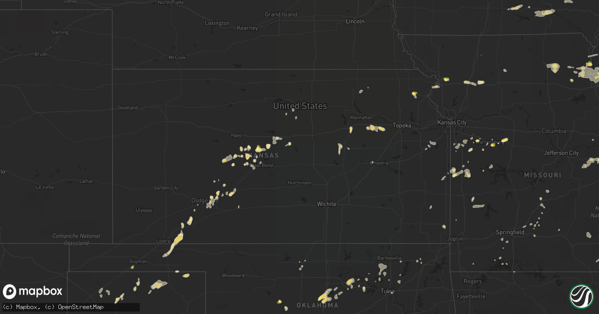
Hail Map in Kansas on August 29, 2022
Get this storm
August 29 map
$229
one time, instant access
Download today. No call, no setup
Keep the $229
Bought the map and want the full workflow? Apply the entire $229 to a subscription within 7 days. None of it is wasted.
Every map, not just this one
This buys you this map. Subscription and you get every map we run, in the markets you choose from a few cities to whole states to nationwide. Plus real-time alerts the moment a storm fires.
Contact data
Name, contact info, occupancy, even credit band for addresses in the footprint. You go from where it hit to who to call.
Become the source they trust
Unlimited branding weather history reports on demand. You already have the documented answer ready for the property owner, and you are the one who showed up with it.
Property data and RoofTrace estimates
Pull up any address you have got, its value and the exact code rules for that jurisdiction, straight from One Click Code. Then RoofTrace estimates the squares, pitch, and roof value, priced the way you price.
Storm reports in Kansas
Kansas
| Date | Description |
|---|---|
| 08/29/20226:35 PM CDT | Em reported downed power poles on us 50. |
| 08/29/20226:05 PM CDT | Public report passed along by media. Time estimate is based on radar. |
| 08/29/20223:46 AM CDT | At 846 PM CDT, a severe thunderstorm was located over Floris, or 12 miles northwest of Beaver, moving south at 25 mph. HAZARD...60 mph wind gusts and quarter size hail. SOURCE...Radar indicated. IMPACT...Minor damage to roofs, siding, and trees is possible. Hail damage to vehicles is expected. Locations impacted include... Turpin, Floris, Bryans Corner, Balko and Boyd. |
| 08/29/20222:52 AM CDT | At 752 PM CDT, a severe thunderstorm was located 4 miles south of Paxico, moving southeast at 10 mph. HAZARD...60 mph wind gusts and half dollar size hail. SOURCE...Radar indicated. IMPACT...Hail damage to vehicles is expected. Expect wind damage to roofs, siding, and trees. Locations impacted include... Eskridge, McFarland, Paxico and Keene. This includes Interstate 70 between mile markers 332 and 340. |
| 08/29/20222:23 AM CDT | At 723 PM CDT, a severe thunderstorm was located over Alma, moving southeast at 10 mph. HAZARD...60 mph wind gusts and half dollar size hail. SOURCE...Radar indicated. IMPACT...Hail damage to vehicles is expected. Expect wind damage to roofs, siding, and trees. Locations impacted include... Alma, Eskridge, McFarland and Volland. This includes Interstate 70 between mile markers 325 and 332. |
| 08/29/20221:34 AM CDT | At 634 PM CDT, a severe thunderstorm was located near Minneola, moving south at 20 mph. HAZARD...70 mph wind gusts and penny size hail. SOURCE...Radar indicated. IMPACT...Expect considerable tree damage. Damage is likely to mobile homes, roofs, and outbuildings. This severe thunderstorm will be near... Minneola around 650 PM CDT.Other locations in the path of this severe thunderstorm includeFowler. |
| 08/29/202212:37 AM CDT | At 537 PM CDT, a severe thunderstorm was located 7 miles north of Hoisington, and is nearly stationary. HAZARD...60 mph wind gusts and quarter size hail. SOURCE...Radar indicated. IMPACT...Hail damage to vehicles is expected. Expect wind damage to roofs, siding, and trees. Locations impacted include... Hoisington, Olmitz and Susank. |
| 08/29/202212:22 AM CDT | At 522 PM CDT, a severe thunderstorm was located over Lancaster, or 10 miles southeast of Horton, moving east at 15 mph. HAZARD...60 mph wind gusts and quarter size hail. SOURCE...Radar indicated. IMPACT...Hail damage to vehicles is expected. Expect wind damage to roofs, siding, and trees. Locations impacted include... Atchison, Effingham, Lancaster, Muscotah, Farmington and Huron. |
| 08/28/202211:58 PM CDT | At 457 PM CDT, a severe thunderstorm was located 9 miles south of Dorrance, or 10 miles southwest of Wilson, moving southeast at 5 mph. HAZARD...60 mph wind gusts and quarter size hail. SOURCE...Radar indicated. IMPACT...Hail damage to vehicles is expected. Expect wind damage to roofs, siding, and trees. Locations impacted include... Odin. |
| 08/28/20229:08 PM CDT | Social media photo of trees blown down in greensburg. Time estimate based off radar. |
| 08/28/20228:19 PM CDT | At 119 PM CDT, a severe thunderstorm was located 8 miles southwest of Butler, moving northeast at 20 mph. HAZARD...60 mph wind gusts and quarter size hail. SOURCE...Radar indicated. IMPACT...Hail damage to vehicles is expected. Expect wind damage to roofs, siding, and trees. Locations impacted include... Butler, Hume, Amoret, Foster and Worland. |
| 08/28/20227:26 PM CDT | A local report indicates 1.50 inch wind near 2 NW ALMA |
| 08/28/20227:26 PM CDT | A local report indicates 60 MPH wind near 2 NW ALMA |
All States Impacted by Hail Map on August 29, 2022
Cities Impacted by Hail Map on August 29, 2022
- Watervliet, MI
- Allegan, MI
- Bloomingdale, MI
- Salem, WI
- Burlington, WI
- Indianola, IA
- Big Rapids, MI
- Dalton City, IL
- Montague, MI
- Whitehall, MI
- Chelsea, MI
- Oakland, IL
- Ridge Farm, IL
- Metcalf, IL
- Indianola, IL
- Brocton, IL
- Catlin, IL
- Georgetown, IL
- Hume, IL
- Chrisman, IL
- Newman, IL
- Fennville, MI
- Hamilton, MI
- Saugatuck, MI
- Holland, MI
- Douglas, MI
- Dana, IN
- Clinton, IN
- Hillsdale, IN
- Paris, IL
- Bennett, IA
- Ainsworth, IA
- Pontiac, IL
- Odell, IL
- Streator, IL
- Ancona, IL
- Wenona, IL
- Cornell, IL
- Long Point, IL
- Saunemin, IL
- Fisher, IL
- Mahomet, IL
- Franklin, IL
- New Berlin, IL
- Jacksonville, IL
- Alexander, IL
- Mansfield, IL
- Newark, MO
- Knox City, MO
- Decatur, IL
- Hammond, IL
- La Place, IL
- Cerro Gordo, IL
- Argenta, IL
- Elliott, IL
- Gibson City, IL
- Frankfort, KS
- Lincoln, IL
- Allerton, IL
- Broadlands, IL
- Fairfield, IL
- Clinton, MO
- Montrose, MO
- Grand Rapids, MI
- Grand Ridge, IL
- Gary, IN
- Lake Station, IN
- Seneca, IL
- Sharon, WI
- Clinton, WI
- Sibley, IL
- Beallsville, OH
- Curwensville, PA
- Clearfield, PA
- West Terre Haute, IN
- Newcomerstown, OH
- West Lafayette, OH
- Pembroke Township, IL
- Lansing, IL
- Chicago Heights, IL
- Glenwood, IL
- Munster, IN
- Highland, IN
- Monon, IN
- Delphi, IN
- Yeoman, IN
- Idaville, IN
- Monticello, IN
- Brookston, IN
- Leonard, MO
- Gibbs, MO
- Novelty, MO
- Hurdland, MO
- La Plata, MO
- Kentland, IN
- Earl Park, IN
- Fowler, IN
- Goodland, IN
- Remington, IN
- Wathena, KS
- Saint Joseph, MO
- Grand Junction, MI
- Washington, IA
- Clinton, IA
- Long Grove, IA
- McCausland, IA
- Calamus, IA
- Thomson, IL
- Bryant, IA
- Grand Mound, IA
- Charlotte, IA
- Savanna, IL
- Camanche, IA
- Preston, IA
- Eldridge, IA
- Welton, IA
- Princeton, IA
- Sabula, IA
- Miles, IA
- Delmar, IA
- De Witt, IA
- Goose Lake, IA
- Driftwood, PA
- Chatsworth, IL
- Melvin, IL
- Strawn, IL
- Beason, IL
- Everest, KS
- Lancaster, KS
- Horton, KS
- Effingham, KS
- Lone Jack, MO
- Loraine, IL
- West Point, IL
- Pleasant Hill, MO
- Kingsville, MO
- Gardner, KS
- Edgerton, KS
- Spring Hill, KS
- Gardner, IL
- Dwight, IL
- Manhattan, IL
- Elwood, IL
- Joliet, IL
- Mokena, IL
- Channahon, IL
- New Lenox, IL
- Sanford, MI
- Shepherd, MI
- Coleman, MI
- Midland, MI
- Shelbyville, MO
- Emden, MO
- Lake Village, IN
- Marne, MI
- Coopersville, MI
- Belmont, MI
- Zeeland, MI
- Rockford, MI
- Allendale, MI
- Comstock Park, MI
- Conklin, MI
- Sparta, MI
- West Olive, MI
- Waterford, WI
- Cooksville, IL
- Richland, IA
- Brighton, IA
- Warsaw, IL
- Basco, IL
- Carthage, IL
- North Judson, IN
- Demotte, IN
- Fair Oaks, IN
- Wheatfield, IN
- Rensselaer, IN
- San Pierre, IN
- Elsie, MI
- Brohman, MI
- Bitely, MI
- White Cloud, MI
- Paris, MI
- Reddick, IL
- Muscatine, IA
- Winterset, IA
- Plymouth, IN
- Bourbon, IN
- Argos, IN
- Carbon, IN
- Brazil, IN
- Hartford, MI
- Nunica, MI
- New Salem, IL
- Colchester, IL
- Wheatland, IA
- New Liberty, IA
- Morocco, IN
- Danville, IL
- Terre Haute, IN
- Lovington, IL
- Chenoa, IL
- Junction City, KS
- Murrayville, IL
- Paloma, IL
- Holden, MO
- Lakeville, OH
- Glenmont, OH
- Bethany, MO
- East Palestine, OH
- Montgomery, IN
- Cannelburg, IN
- Ashland, IL
- Herington, KS
- Offerle, KS
- Lewis, KS
- Kinsley, KS
- Valparaiso, IN
- Hobart, IN
- Tolono, IL
- Philo, IL
- Sidney, IL
- Savoy, IL
- Potomac, IL
- Saint Joseph, IL
- Rossville, IL
- Rantoul, IL
- Loda, IL
- Thomasboro, IL
- Buckley, IL
- Roberts, IL
- Paxton, IL
- Homer, IL
- Armstrong, IL
- Collison, IL
- Muncie, IL
- Urbana, IL
- Gifford, IL
- Ogden, IL
- Fairmount, IL
- Cissna Park, IL
- Champaign, IL
- Oakwood, IL
- Ludlow, IL
- Penfield, IL
- Fithian, IL
- Royal, IL
- Rankin, IL
- La Monte, MO
- Hughesville, MO
- Sedalia, MO
- Knob Noster, MO
- Pleasant Plains, IL
- Springfield, IL
- Hopedale, IL
- Minier, IL
- Barry, IL
- Genoa City, WI
- Lake Geneva, WI
- Peculiar, MO
- Columbus Junction, IA
- Crawfordsville, IA
- Columbus City, IA
- Wayland, IA
- Francesville, IN
- Winamac, IN
- Medaryville, IN
- Chillicothe, OH
- Waverly, OH
- Freeman, MO
- Stoutland, MO
- Richland, MO
- Ewing, IL
- McLeansboro, IL
- Macedonia, IL
- Dahlgren, IL
- Belle Rive, IL
- Plainwell, MI
- Otsego, MI
- Chariton, IA
- Lovilia, IA
- Russell, IA
- Melrose, IA
- Bonfield, IL
- La Porte, IN
- Minooka, IL
- Hamilton, IL
- Maroa, IL
- Virginia, IL
- Beardstown, IL
- Arenzville, IL
- Coshocton, OH
- Hamilton, MO
- Kidder, MO
- Cameron, MO
- Waverly, IL
- Chandlerville, IL
- Bath, IL
- Tallula, IL
- Loami, IL
- Marshfield, MO
- Strafford, MO
- Packwood, IA
- Fairfield, IA
- Tipton, IN
- Beloit, KS
- Mount Carroll, IL
- Lanark, IL
- Shannon, IL
- Hoisington, KS
- Olmitz, KS
- Norwalk, IA
- Saint Charles, IA
- Prole, IA
- Patterson, IA
- Martensdale, IA
- Bevington, IA
- Dexter, MO
- Bloomfield, MO
- Dixon, IA
- Cosby, MO
- Easton, MO
- Ensign, KS
- Niangua, MO
- Columbus, OH
- Culver, IN
- Knox, IN
- Pittsfield, IL
- Sullivan, IL
- Beecher, IL
- Walkerville, MI
- Hesperia, MI
- Westville, IN
- Crete, IL
- Saint John, IN
- Dyer, IN
- Piper City, IL
- Gilman, IL
- Ashkum, IL
- Danforth, IL
- Kempton, IL
- Blakesburg, IA
- Ottumwa, IA
- Drakesville, IA
- Albia, IA
- Bloomfield, IA
- Moravia, IA
- Agency, IA
- Unionville, IA
- Barnard, KS
- Seymour, MO
- Bethesda, OH
- Iuka, IL
- Dix, IL
- Walnut Hill, IL
- Kell, IL
- Dodge City, KS
- Circleville, OH
- Ramona, KS
- Hope, KS
- Joelton, TN
- Goodlettsville, TN
- Whites Creek, TN
- Jeffersonville, IN
- Yukon, OK
- Wayne City, IL
- Burkesville, KY
- Norman, OK
- Huntingburg, IN
- Verden, OK
- Chickasha, OK
- Spearville, KS
- Richmond, KY
- Louisville, KY
- Fairdale, KY
- Fort Sumner, NM
- Pond Creek, OK
- Kremlin, OK
- Big Clifty, KY
- Pawnee, OK
- Amarillo, TX
- Geary, OK
- Calumet, OK
- Broseley, MO
- Melbourne, AR
- Sage, AR
- Ozark, AR
- Cleveland, OK
- Stillwater, OK
- Coyle, OK
- Perkins, OK
- Cache, OK
- Indiahoma, OK
- Skiatook, OK
- Fort Cobb, OK
- Barnsdall, OK
- Milnesand, NM
- Morton, TX
- Tatum, NM
- Tulia, TX
- Mustang, OK
- Gotebo, OK
- Mountain View, OK
- Elida, NM
- Abernathy, TX
- Happy, TX
- Weir, KS
- Anson, TX
- Reeds Spring, MO
- Whiteface, TX
- Pecos, TX
- Childress, TX
- Matador, TX
- Otis, KS
- Bison, KS
- Alexander, KS
- Bazine, KS
- Chaffee, MO
- Lockney, TX
- Floydada, TX
- Loving, NM
- Idalou, TX
- Petersburg, TX
- Apache, OK
- Quincy, IL
- Ellsworth, KS
- Kanopolis, KS
- Meade, KS
- Plains, KS
- Turpin, OK
- Forgan, OK
- Kismet, KS
- Anton, TX
- Levelland, TX
- Great Bend, KS
- Ewing, MO
- Maljamar, NM
- Lovington, NM
- Muleshoe, TX
- Sudan, TX
- Earth, TX
- Oran, MO
- Advance, MO
- Whitewater, MO
- Cape Girardeau, MO
- Booker, TX
- Nixa, MO
- Clever, MO
- Vinson, OK
- Seminole, OK
- Prague, OK
- Nazareth, TX
- Hart, TX
- Dimmitt, TX
- Ropesville, TX
- Meadow, TX
- Lorenzo, TX
- Tokio, TX
- Plains, TX
- Denver City, TX
- Crowell, TX
- Vernon, TX
- La Crosse, KS
- Bland, MO
- Balko, OK
- La Grange, MO
- Monticello, MO
- Lewistown, MO
- Canton, MO
- Payson, IL
- Taylor, MO
- Maywood, MO
- Palmyra, MO
- Durham, MO
- Philadelphia, MO
- Flomot, TX
- Wright, KS
- Odell, TX
- Capitan, NM
- Nekoma, KS
- Ness City, KS
- Albert, KS
- Winchester, KY
- Irvine, KY
- Amoret, MO
- Warrensburg, MO
- Billings, MO
- Republic, MO
- Enid, OK
- Hominy, OK
- Silverton, TX
- Blanchard, OK
- Amber, OK
- Owasso, OK
- Collinsville, OK
- Claremore, OK
- Jerico Springs, MO
- Lamar, MO
- Sheldon, MO
- Stockton, MO
- Ada, OK
- Canyon, TX
- Claude, TX
- Longview, IL
- Sutter, IL
- Lawton, OK
- Glencoe, OK
- Rosedale, IN
- Anadarko, OK
- Gracemont, OK
- Lebanon, MO
- Spearman, TX
- Kress, TX
- Plainview, TX
- Hamlin, TX
- Tecumseh, OK
- Shawnee, OK
- Linden, TN
- Wilson, KS
- Mulhall, OK
- Rogers, NM
- Eskridge, KS
- Paxico, KS
- Alma, KS
- Dumas, TX
- Sunray, TX
- Brownfield, TX
- Perryton, TX
- Oreana, IL
- Crosbyton, TX
- Frederick, OK
- Garden City, MO
- Dale, IN
- Lincoln City, IN
- Gentryville, IN
- Santa Claus, IN
- Holland, IN
- Ferdinand, IN
- Hoopeston, IL
- Blue Mound, IL
- Moweaqua, IL
- Macon, IL
- Stonington, IL
- Stratford, TX
- Wellsville, KS
- Rule, TX
- Owensville, IN
- Poseyville, IN
- Griffin, IN
- Mount Carmel, IL
- New Harmony, IN
- Dorrance, KS
- Bunker Hill, KS
- Ford, KS
- Hanston, KS
- Harrisonville, MO
- Johnsonville, IL
- Bluford, IL
- Sims, IL
- Mount Vernon, IL
- Opdyke, IL
- Keenes, IL
- Elgin, OK
- Jal, NM
- Paducah, TX
- Old Glory, TX
- Hobbs, NM
- Bethel, MO
- La Belle, MO
- El Dorado Springs, MO
- Milo, MO
- Scammon, KS
- Charleston, MO
- Mountain Grove, MO
- Berea, KY
- Waco, KY
- Vinita, OK
- Lindsay, OK
- Purcell, OK
- Centerville, TN
- Earlsboro, OK
- Lexington, OK
- Noble, OK
- Washington, OK
- Van Horn, TX
- Latham, IL
- Chestnut, IL
- Kenney, IL
- Cross Plains, IN
- Dubois, IN
- Butler, MO
- Walnut, KS
- Ribera, NM
- Eldorado, OK
- Elmer, OK
- Norwich, OH
- Graymont, IL
- Jetmore, KS
- Temple, OK
- Marble Hill, MO
- Claflin, KS
- Greensburg, KS
- Watonga, OK
- Emporia, KS
- Saint Anthony, IN
- Madison, IN
- Nowata, OK
- Hartville, MO
- Foster, MO
- Amsterdam, MO
- Omaha, AR
- Hollister, MO
- Stendal, IN
- Lamar, IN
- Sierra Blanca, TX
- Dalhart, TX
- Ellington, MO
- Hitchcock, OK
- Sweetwater, TX
- Panhandle, TX
- Springdale, AR
- Fayetteville, AR
- Tinnie, NM
- Fort Hancock, TX
- Paint Rock, TX
- Russellville, AL
- Tuscumbia, AL
- Orlando, OK
- Crescent, OK
- Guthrie, OK
- Farwell, TX
- Cedarbluff, MS
- Littlefield, TX
- Lubbock, TX
- Spur, TX
- Tell, TX
- Gallatin, MO
- Terlton, OK
- Rush Center, KS
- Golden Gate, IL
- Ellery, IL
- Albion, IL
- Gruver, TX
- Wanette, OK
- Salt Flat, TX
- Mentone, TX
- Post, TX
- Amherst, TX
- Weed, NM
- Gerald, MO
- Rosebud, MO
- Ottawa, KS
- Chilhowee, MO
- French Lick, IN
- West Baden Springs, IN
- Jasper, IN
- Adamsville, OH
- Centerview, MO
- Atwood, IL
- Pawnee Rock, KS
- Keota, OK
- Laredo, MO
- Chula, MO
- Alex, OK
- Oronogo, MO
- Liberal, MO
- Rozel, KS
- Omega, OK
- Hamersville, OH
- Bethel, OH
- Hurricane Mills, TN
- Waverly, TN
- Oklahoma City, OK
- Alton, MO
- Elkins, AR
- Paden, OK
- Mcloud, OK
- Newalla, OK
- Faxon, OK
- Whiteman Air Force Base, MO
- Ralls, TX
- Crane, MO
- Bartlesville, OK
- Pawhuska, OK
- Clay City, KY
- Olton, TX
- Maple, TX
- New Haven, MO
- Leslie, MO
- Gail, TX
- Roscoe, TX
- De Mossville, KY
- Falmouth, KY
- Perry, OK
- Mount Erie, IL
- West Salem, IL
- Eminence, MO
- Aurora, MO
- Prescott, KS
- Pleasanton, KS
- Mound City, KS
- Jeffersonville, KY
- Fowler, KS
- Louisa, KY
- Fort Sill, OK
- Shell Knob, MO
- Kimberling City, MO
- Aberdeen, MS
- Breckenridge, MO
- Dry Ridge, KY
- Willisburg, KY
- Blue Rapids, KS
- Golconda, IL
- Lerna, IL
- Belle, MO
- Owensville, MO
- Williamstown, KY
- Morning View, KY
- Butler, KY
- Crittenden, KY
- Hampton, KY
- Smithland, KY
- Grovespring, MO
- Grand Rivers, KY
- Goreville, IL
- Maple Hill, KS
- Foster, WV
- Danville, WV
- Julian, WV
- Chapmanville, WV
- Harts, WV
- Big Creek, WV
- New Florence, MO
- Hermann, MO
- River, KY
- Meally, KY
- Tomahawk, KY
- Boons Camp, KY
- Paintsville, KY
- Bellmont, IL
- Browns, IL
- Grayville, IL
- Tuttle, OK
- Tulsa, OK
- Jennings, OK
- Olmsted, IL
- Kevil, KY
- Villa Ridge, IL
- Grand Chain, IL
- Rush Springs, OK
- Powell, MO
- Florence, AL
- Sugar Tree, TN
- Prue, OK
- Quitaque, TX
- Shallowater, TX
- Loveland, OK
- Oologah, OK
- Cyril, OK
- Plantersville, MS
- Fulton, MS
- Tupelo, MS
- Onarga, IL
- Blackstone, IL
- Kinsman, IL
- Forest, IN
- Michigantown, IN
- Frankfort, IN
- Burlington, IN
- Russiaville, IN
- Cutler, IN
- Bringhurst, IN
- Flora, IN
- Kokomo, IN
- Cape Fair, MO
- Galena, MO
- Shoals, IN
- Goodwell, OK
- Wheeling, MO
- Alden, MN
- Hartland, MN
- Albert Lea, MN
- Grand Meadow, MN
- Ridgeview, WV
- Russell, KS
- Tahoka, TX
- Smyer, TX
- Wolfforth, TX
- Turkey, TX
- Clarendon, TX
- Lakeview, TX
- Wilmette, IL
- Chicago, IL
- Streamwood, IL
- Hanover Park, IL
- Lincolnwood, IL
- Kenilworth, IL
- Roselle, IL
- Bensenville, IL
- Kingston, IL
- Sycamore, IL
- Schaumburg, IL
- Arlington Heights, IL
- Winnetka, IL
- Wayne, IL
- Mount Prospect, IL
- Wasco, IL
- Palatine, IL
- Evanston, IL
- Park Ridge, IL
- Golf, IL
- Wood Dale, IL
- Wheeling, IL
- South Elgin, IL
- Maple Park, IL
- Saint Charles, IL
- Skokie, IL
- Rolling Meadows, IL
- Hoffman Estates, IL
- Malta, IL
- Hampshire, IL
- Addison, IL
- Franklin Park, IL
- West Chicago, IL
- Elgin, IL
- Niles, IL
- Burlington, IL
- Itasca, IL
- Dekalb, IL
- Schiller Park, IL
- Carol Stream, IL
- Glendale Heights, IL
- Elk Grove Village, IL
- Cortland, IL
- Kirkland, IL
- Harwood Heights, IL
- Glenview, IL
- Bloomingdale, IL
- Glencoe, IL
- Medinah, IL
- Highland Park, IL
- Esmond, IL
- Clare, IL
- Barrington, IL
- Bartlett, IL
- Northbrook, IL
- Elburn, IL
- Prospect Heights, IL
- Des Plaines, IL
- Genoa, IL
- Morton Grove, IL
- Churubusco, IN
- Convoy, OH
- Rudolph, OH
- Continental, OH
- Waterville, OH
- Hazel Crest, IL
- Arcola, IN
- Craigville, IN
- South Whitley, IN
- Ligonier, IN
- Montpelier, OH
- Manteno, IL
- North Webster, IN
- Crown Point, IN
- New Haven, IN
- Larwill, IN
- Thayer, IN
- Lakeville, IN
- Angola, IN
- Hamilton, IN
- Leo, IN
- Bowling Green, OH
- Wauseon, OH
- Steger, IL
- Huntington, IN
- Griffith, IN
- Syracuse, IN
- Hicksville, OH
- Wakarusa, IN
- La Crosse, IN
- Zanesville, IN
- Middle Point, OH
- Grelton, OH
- New Bavaria, OH
- Defiance, OH
- Milford, IN
- Ney, OH
- Monclova, OH
- Holgate, OH
- Warsaw, IN
- Decatur, IN
- Oakwood, OH
- Saint Joe, IN
- Delphos, OH
- Ossian, IN
- Deshler, OH
- Country Club Hills, IL
- Van Wert, OH
- Rome City, IN
- Haviland, OH
- Fremont, IN
- Boone Grove, IN
- Leesburg, IN
- Flossmoor, IL
- Richton Park, IL
- Urbana, IN
- Kingsford Heights, IN
- Andrews, IN
- Ohio City, OH
- Laotto, IN
- Auburn, IN
- Etna Green, IN
- Mark Center, OH
- Edgerton, OH
- Nappanee, IN
- Grant Park, IL
- Fort Jennings, OH
- Cromwell, IN
- Pleasant Lake, IN
- Stryker, OH
- Hudson, IN
- Venedocia, OH
- Monroeville, IN
- Napoleon, OH
- Merrillville, IN
- Waterloo, IN
- Tinley Park, IL
- Custar, OH
- Bradley, IL
- Hamler, OH
- Huntertown, IN
- Bluffton, IN
- Grovertown, IN
- Monee, IL
- Union Mills, IN
- Park Forest, IL
- Lagrange, IN
- Columbia City, IN
- Albion, IN
- Frankfort, IL
- Neapolis, OH
- North Liberty, IN
- Scott, OH
- Monroe, IN
- Evansport, OH
- Cedar Lake, IN
- Kendallville, IN
- Matteson, IL
- Kankakee, IL
- Goshen, IN
- Willshire, OH
- Sherwood, OH
- Wolcottville, IN
- Bryan, OH
- Peotone, IL
- Wilmington, IL
- South Milford, IN
- North Manchester, IN
- Hamlet, IN
- Edon, OH
- Uniondale, IN
- Wawaka, IN
- Spencerville, IN
- University Park, IL
- Pierceton, IN
- Thornton, IL
- Kimmell, IN
- Latty, OH
- Olympia Fields, IL
- Roanoke, IN
- Fort Wayne, IN
- Schneider, IN
- Antwerp, OH
- Melrose, OH
- Tontogany, OH
- McClure, OH
- Ridgeville Corners, OH
- Shelby, IN
- Bremen, IN
- Harlan, IN
- Delta, OH
- Bourbonnais, IL
- Paulding, OH
- Grover Hill, OH
- Corunna, IN
- Milton Center, OH
- Wren, OH
- Avilla, IN
- Garrett, IN
- Liberty Center, OH
- Grand Rapids, OH
- Archbold, OH
- New Paris, IN
- Hoagland, IN
- Schererville, IN
- Hebron, IN
- Swanton, OH
- Markle, IN
- Lowell, IN
- Whitehouse, OH
- Cecil, OH
- Hanna, IN
- Cloverdale, OH
- Ashley, IN
- Malinta, OH
- Grabill, IN
- Wanatah, IN
- Woodburn, IN
- Homewood, IL
- Weston, OH
- Momence, IL
- Payne, OH
- Kouts, IN
- Yoder, IN
- Butler, IN
- Walkerton, IN
- Chebanse, IL
- Clifton, IL
- Buckingham, IL
- Herscher, IL
- Cabery, IL
- Washington, MO
- Clawson, MI
- Ecorse, MI
- Haslett, MI
- Owosso, MI
- Utica, MI
- Linden, MI
- Romulus, MI
- Melvindale, MI
- Hamtramck, MI
- Clinton Township, MI
- Ray, MI
- Fraser, MI
- Leonard, MI
- Ypsilanti, MI
- Perry, MI
- Vermontville, MI
- Rockwood, MI
- Commerce Township, MI
- Eastpointe, MI
- Howell, MI
- Mason, MI
- Saint Clair Shores, MI
- River Rouge, MI
- Charlotte, MI
- Potterville, MI
- Northville, MI
- Madison Heights, MI
- Lake Orion, MI
- Grosse Pointe, MI
- Milford, MI
- Macatawa, MI
- Dansville, MI
- Casco, MI
- Portland, MI
- Fenton, MI
- Livonia, MI
- Eaton Rapids, MI
- Center Line, MI
- Gaines, MI
- Fair Haven, MI
- Riverview, MI
- Romeo, MI
- Oak Park, MI
- Clarkston, MI
- Trenton, MI
- Berkley, MI
- Lowell, MI
- Waterford, MI
- Wayland, MI
- Walled Lake, MI
- Dearborn, MI
- Sunfield, MI
- Huntington Woods, MI
- Canton, MI
- Spring Lake, MI
- Dimondale, MI
- Southfield, MI
- Taylor, MI
- Byron, MI
- Belleville, MI
- Roseville, MI
- Swartz Creek, MI
- Highland Park, MI
- Redford, MI
- Freeport, MI
- East Lansing, MI
- Williamston, MI
- Franklin, MI
- Lansing, MI
- Morrice, MI
- Flat Rock, MI
- Grosse Ile, MI
- Warren, MI
- New Haven, MI
- Hastings, MI
- Wayne, MI
- Inkster, MI
- Richmond, MI
- Grandville, MI
- Macomb, MI
- Lincoln Park, MI
- Novi, MI
- Royal Oak, MI
- Laingsburg, MI
- Mulliken, MI
- Wyandotte, MI
- Oakland, MI
- Hazel Park, MI
- Brighton, MI
- Pleasant Ridge, MI
- Harrison Township, MI
- Bath, MI
- Highland, MI
- Webberville, MI
- Alto, MI
- Ferndale, MI
- Keego Harbor, MI
- Eagle, MI
- Armada, MI
- New Boston, MI
- Mount Clemens, MI
- Bancroft, MI
- Fowlerville, MI
- Harper Woods, MI
- Pontiac, MI
- Allen Park, MI
- Holly, MI
- West Bloomfield, MI
- Dorr, MI
- Southgate, MI
- Plymouth, MI
- Farmington, MI
- Bloomfield Hills, MI
- Clarksville, MI
- Holt, MI
- Middleville, MI
- Hartland, MI
- Grand Blanc, MI
- Caledonia, MI
- Birmingham, MI
- Washington, MI
- Byron Center, MI
- Garden City, MI
- Woodland, MI
- Durand, MI
- Sterling Heights, MI
- Wyoming, MI
- Davisburg, MI
- Okemos, MI
- Grand Haven, MI
- Hudsonville, MI
- Grand Ledge, MI
- New Baltimore, MI
- Lake Odessa, MI
- Ada, MI
- Detroit, MI
- White Lake, MI
- Westland, MI
- Troy, MI
- Dearborn Heights, MI
- Rochester, MI
- Jenison, MI
- Dewitt, MI
- Auburn Hills, MI
- Bellevue, MI
- Marshall, MI
- Albion, MI
- Battle Creek, MI
- Parma, MI
- Ceresco, MI
- Freeland, MI
- Breckenridge, MI
- Saint Louis, MI
- Merrill, MI
- Mount Pleasant, MI
- Wheeler, MI
- Hemlock, MI
- Mount Morris, MI
- Oakley, MI
- Lapeer, MI
- Davison, MI
- Flint, MI
- New Lothrop, MI
- Saint Johns, MI
- Corunna, MI
- Bannister, MI
- Ovid, MI
- Flushing, MI
- Lennon, MI
- Ashley, MI
- Chesaning, MI
- Burton, MI
- Perrinton, MI
- Henderson, MI
- Monroe, MI
- Genesee, MI


