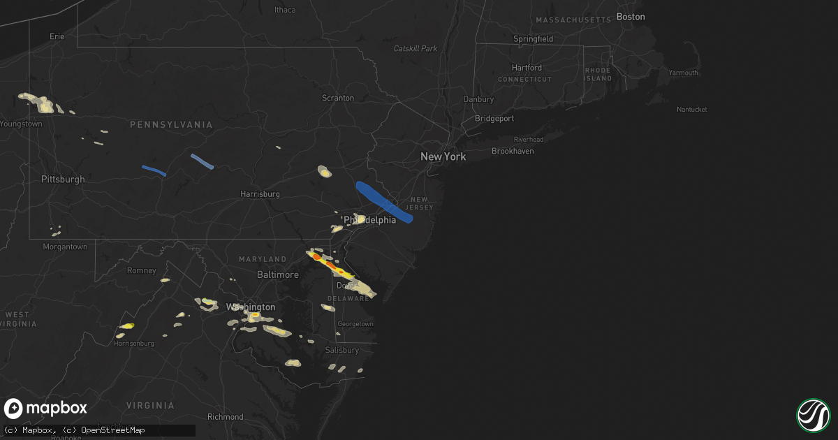
Hail Map in New Jersey on August 28, 2020
Get this storm
August 28 map
$229
one time, instant access
Download today. No call, no setup
Keep the $229
Bought the map and want the full workflow? Apply the entire $229 to a subscription within 7 days. None of it is wasted.
Every map, not just this one
This buys you this map. Subscription and you get every map we run, in the markets you choose from a few cities to whole states to nationwide. Plus real-time alerts the moment a storm fires.
Contact data
Name, contact info, occupancy, even credit band for addresses in the footprint. You go from where it hit to who to call.
Become the source they trust
Unlimited branding weather history reports on demand. You already have the documented answer ready for the property owner, and you are the one who showed up with it.
Property data and RoofTrace estimates
Pull up any address you have got, its value and the exact code rules for that jurisdiction, straight from One Click Code. Then RoofTrace estimates the squares, pitch, and roof value, priced the way you price.
Storm reports in New Jersey
New Jersey
| Date | Description |
|---|---|
| 08/28/20204:43 PM CDT | Several reports of downed power lines near central avenue in berkeley. Time estimated from radar. |
| 08/28/20204:40 PM CDT | Several reports of trees and power lines down in the island heights area. Time estimated from radar. |
| 08/28/20204:38 PM CDT | Downed trees and wires near sinclair avenue and clairmore avenue in lanoka harbor. Time estimated from radar. |
| 08/28/20204:38 PM CDT | Several trees downed as the bow echo moved across the county. Time estimated from radar. |
| 08/28/20204:35 PM CDT | Downed trees and power lines in several locations in forked river. Time estimated from radar. |
| 08/28/20204:30 PM CDT | Several reports of downed trees and power lines with numerous power outages in the toms river area. Time estimated from radar. |
| 08/28/20204:06 PM CDT | Downed power lines near circle drive in allentown. Time estimated from radar. |
| 08/28/20204:06 PM CDT | Downed trees and wires near the ellisdale-crosswicks road and province line road intersection. Time estimated from radar. |
| 08/28/20204:06 PM CDT | Large tree downed on acton station road. Time estimated from radar. |
| 08/28/20204:05 PM CDT | Njwxnet measured 60 mph wind gust at lower alloways creek. |
| 08/28/20203:57 PM CDT | Trees caused power outage at us 206 and mansfield rd. East. Time estimated from radar. |
| 08/28/20203:55 PM CDT | Downed power lines near groveville road. Time estimated from radar. |
| 08/28/20203:55 PM CDT | Downed trees and wires near amboy road and u.s. Highway 206. Time estimated from radar. |
| 08/28/20203:53 PM CDT | Downed tree limbs and wires near bunting avenue. Time estimated from radar. |
| 08/28/20203:47 PM CDT | Downed power lines near evergreen drive. Time estimated from radar. |
| 08/28/202012:28 AM CDT | At 528 PM EDT, severe thunderstorms were located along a line extending from Chesilhurst to near Millville to near Greenwich, moving east at 45 mph. HAZARD...60 mph wind gusts and quarter size hail. SOURCE...Radar indicated. IMPACT...Minor damage to vehicles is possible. Wind damage to roofs, siding, trees, and power lines is possible. Locations impacted include... Vineland, Atlantic City, Millville, Bridgeton, Ocean City, Cape May, Cumberland, Barnegat, Pleasantville, Hammonton, Somers Point, Ventnor City, Brigantine, Northfield, Absecon, Clayton, Berlin, Shamong, Margate City and Buena.This includes the following highways... Garden State Parkway between mile markers 0 and 69. Atlantic City Expressway between mile markers 0 and 39. |
| 08/27/202011:17 PM CDT | At 416 PM EDT, a severe thunderstorm was located 9 miles south of Fortesque, or 16 miles northwest of Cape May, moving east at 40 mph. HAZARD...70 mph wind gusts and ping pong ball size hail. SOURCE...Radar indicated. IMPACT...People and animals outdoors will be injured. Expect hail damage to roofs, siding, windows, and vehicles. Expect considerable tree damage. Wind damage is also likely to mobile homes, roofs, and outbuildings. Locations impacted include... Cape May, North Wildwood, Wildwood Crest, Sea Isle City, Avalon, West Cape May, Stone Harbor, Cape May Court House, Scotch Bonnet, Diamond Beach, Green Creek, Goshen, Rio Grande, North Cape May, Villas, West Wildwood, Erma and Whitesboro-Burleigh.This includes Garden State Parkway between mile markers 0 and 15. |
| 08/27/202010:52 PM CDT | At 352 PM EDT, severe thunderstorms were located along a line extending from Kennett Square to near Bear to Hope Creek, moving east at 30 mph. HAZARD...60 mph wind gusts and quarter size hail. SOURCE...Radar indicated. IMPACT...Minor damage to vehicles is possible. Wind damage to roofs, siding, trees, and power lines is possible. Locations impacted include... Wilmington, Newark, Chester, Pennsville, Carneys Point, Folcroft, Swarthmore, Elsmere, Paulsboro, Kennett Square, New Castle, Penns Grove, Salem, Woodstown, Alloway, Quinton, Swedesboro, Delaware City, Elmer and Newport.This includes the following highways... New Jersey Turnpike between exits 1 and 2. Interstate 95 in Pennsylvania between mile markers 0 and 10. Interstate 95 in Delaware between mile markers 2 and 23. Interstate 295 in New Jersey between mile markers 0 and 18. Interstate 476 in Pennsylvania between mile markers 0 and 4. |
All States Impacted by Hail Map on August 28, 2020
Cities Impacted by Hail Map on August 28, 2020
- Howard City, MI
- Pleasant Hill, OH
- Laura, OH
- Morland, KS
- Penokee, KS
- Hill City, KS
- Pritchett, CO
- Kim, CO
- Concordia, KS
- Winthrop, IA
- Ryan, IA
- Masonville, IA
- Coggon, IA
- Manchester, IA
- Sullivan, OH
- Fredericktown, OH
- Mount Vernon, OH
- Syracuse, KS
- Iola, TX
- Dover, DE
- Havre De Grace, MD
- Cecilton, MD
- Warwick, MD
- Smyrna, DE
- Townsend, DE
- Galena, MD
- Middletown, DE
- North East, MD
- Clayton, DE
- Earleville, MD
- Kennett Square, PA
- Chadds Ford, PA
- Traer, IA
- Gladbrook, IA
- Ashland, OH
- Ashley, MI
- Ithaca, MI
- Grinnell, KS
- Spencer, OH
- Litchfield, OH
- Valley City, OH
- Medina, OH
- Grafton, OH
- Wellington, OH
- Columbia Station, OH
- Morgantown, WV
- Hoxie, KS
- Andrews Air Force Base, MD
- Fort Washington, MD
- Temple Hills, MD
- Suitland, MD
- Clinton, MD
- Oxon Hill, MD
- Alexandria, VA
- Cimarron, KS
- Stratford, TX
- Hazleton, IA
- Fairbank, IA
- Immokalee, FL
- Winona, KS
- Olsburg, KS
- Kent City, MI
- Grant, MI
- Cedar Springs, MI
- Bailey, MI
- Sparta, MI
- Ionia, MI
- Muir, MI
- Lucas, KS
- Owings, MD
- Prince Frederick, MD
- Huntingtown, MD
- Brandywine, MD
- Waldorf, MD
- Port Republic, MD
- Aquasco, MD
- Woodbridge, VA
- New Lothrop, MI
- Tribune, KS
- Leoti, KS
- Lakeview, MI
- Morley, MI
- Greenville, PA
- Gore, VA
- Winchester, VA
- Dundee, IA
- Independence, IA
- Brandon, IA
- Hopkinton, IA
- Center Junction, IA
- Rowley, IA
- Delhi, IA
- Anamosa, IA
- Langworthy, IA
- Monticello, IA
- Quasqueton, IA
- West Chester, PA
- Mount Morris, PA
- Akron, OH
- Clinton, OH
- Hockessin, DE
- Avondale, PA
- Wilmington, DE
- Arcanum, OH
- Moline, KS
- Grainfield, KS
- Gove, KS
- Elkton, MD
- Aberdeen, MD
- Dover Afb, DE
- Camden Wyoming, DE
- Magnolia, DE
- Perry Point, MD
- Port Deposit, MD
- Chesapeake City, MD
- Perryville, MD
- Quinter, KS
- Park, KS
- Brooklyn, MI
- Medicine Lodge, KS
- New Bethlehem, PA
- Mayport, PA
- Fairmount City, PA
- Scott City, KS
- Healy, KS
- Newton, IA
- Union, IA
- Saugatuck, MI
- Douglas, MI
- Brookfield, WI
- Pewaukee, WI
- Waukesha, WI
- Elm Grove, WI
- Otsego, MI
- Hopkins, MI
- Menomonee Falls, WI
- South Haven, MI
- Milwaukee, WI
- Hamilton, MI
- Allegan, MI
- Fennville, MI
- Vermillion, KS
- Carmichaels, PA
- Lakin, KS
- Marshalltown, IA
- Dysart, IA
- Garrison, IA
- Garwin, IA
- Toledo, IA
- The Plains, VA
- Middleburg, VA
- Aldie, VA
- Tipton, KS
- Hunter, KS
- High View, WV
- Elyria, OH
- Holton, KS
- Valley Falls, KS
- Denison, KS
- Sedan, KS
- Cuba City, WI
- Oakley, KS
- Caldwell, OH
- Melbourne, IA
- Laurel, IA
- Flint, MI
- Flushing, MI
- Mount Morris, MI
- Martin, MI
- Greenville, MI
- Marienthal, KS
- Aberdeen, MS
- Belle Plaine, KS
- Udall, KS
- Oxford, KS
- Shelby, OH
- Waldo, KS
- Luray, KS
- Osborne, KS
- Kankakee, IL
- Herscher, IL
- Wooster, OH
- Cedar Vale, KS
- Crawford, WV
- Rockwell, NC
- China Grove, NC
- Salisbury, NC
- Kannapolis, NC
- Haymarket, VA
- Felicity, OH
- Bethel, OH
- Hume, VA
- Flint Hill, VA
- Huntly, VA
- Lansdowne, PA
- Clifton Heights, PA
- Springfield, PA
- Havertown, PA
- Upper Darby, PA
- Drexel Hill, PA
- Philadelphia, PA
- Charlestown, MD
- Bannister, MI
- Pompeii, MI
- Perrinton, MI
- Sumner, MI
- Johnson, KS
- Winfield, KS
- Lovelady, TX
- Dubuque, IA
- Potosi, WI
- Sherrill, IA
- Larned, KS
- Jeromesville, OH
- Kutztown, PA
- Lenhartsville, PA
- Fleetwood, PA
- Hamburg, PA
- Swartz Creek, MI
- Pullman, MI
- Colfax, IA
- Prairie City, IA
- Clifton, KS
- Bear, DE
- Sunbury, OH
- North Judson, IN
- Winston Salem, NC
- Farmdale, OH
- Kinsman, OH
- Wynnewood, PA
- Darby, PA
- Morton, PA
- Broomall, PA
- Glenolden, PA
- Ardmore, PA
- Swarthmore, PA
- Lyon Station, PA
- Shoemakersville, PA
- Cheltenham, MD
- Kellogg, IA
- Deforest, WI
- Dane, WI
- Benton, WI
- Shullsburg, WI
- Pierson, MI
- Coral, MI
- Eau Claire, MI
- Sodus, MI
- Hadley, PA
- Stoneboro, PA
- Clarks Mills, PA
- Sharpsville, PA
- Jackson Center, PA
- Fredonia, PA
- Mercer, PA
- Huron, OH
- Berlin Heights, OH
- Marshall, VA
- Longton, KS
- Elk City, KS
- Newcastle, NE
- Gilman, IA
- Frankfort, KS
- Jamestown, SC
- Garden City, KS
- Casnovia, MI
- Catharpin, VA
- Ashburn, VA
- Broad Run, VA
- Gainesville, VA
- Chantilly, VA
- Clearwater, KS
- Elwell, MI
- Saint Louis, MI
- Alma, MI
- Lyons, MI
- Annandale, VA
- McLean, VA
- Arlington, VA
- Fairfax, VA
- Vienna, VA
- Oakton, VA
- Falls Church, VA
- Dunn Loring, VA
- Grinnell, IA
- Bellevue, MI
- Shiloh, OH
- Manter, KS
- Glen Haven, WI
- Cassville, WI
- Muskegon, MI
- Gowen, MI
- Twin Lake, MI
- Fenwick, MI
- Pewamo, MI
- Orleans, MI
- Holton, MI
- Fowler, MI
- Saint Johns, MI
- Westphalia, MI
- Belding, MI
- Sand Lake, MI
- Ravenna, MI
- Rockford, MI
- Woodville, VA
- Washington, VA
- Sperryville, VA
- Castleton, VA
- Owosso, MI
- Merion Station, PA
- Wayne, PA
- Holmes, PA
- Wallingford, PA
- Haverford, PA
- Villanova, PA
- Media, PA
- Newtown Square, PA
- Bryn Mawr, PA
- Folsom, PA
- Westover, MD
- Princess Anne, MD
- Clarksburg, MD
- Barnesville, MD
- Boyds, MD
- Protection, KS
- Denton, MD
- Uniontown, OH
- Watertown, WI
- Wellington, KS
- Burden, KS
- Lenoir, NC
- Mitchellville, IA
- Runnells, IA
- North Star, MI
- Burton, MI
- Davison, MI
- Oakley, MI
- Corunna, MI
- Chesaning, MI
- Montrose, MI
- Bagley, WI
- Chester Heights, PA
- Glen Mills, PA
- Aston, PA
- Fulks Run, VA
- Elk Falls, KS
- Grenola, KS
- Clinton, MI
- Sylvan Grove, KS
- Galion, OH
- Spring, TX
- Weston, WV
- Horner, WV
- Lorton, VA
- Manassas, VA
- Fairfax Station, VA
- Reddick, IL
- Bonfield, IL
- Kittanning, PA
- Adrian, PA
- Templeton, PA
- Waynesburg, PA
- Spraggs, PA
- Hinton, VA
- Dayton, VA
- Jetmore, KS
- Ingalls, KS
- Zanesfield, OH
- West Liberty, OH
- Ellis, KS
- Eureka, KS
- Hockley, TX
- Earlville, IA
- Mazon, IL
- Gardner, IL
- Lancaster, WI
- Zearing, IA
- Monroe, IA
- Rushsylvania, OH
- Belle Center, OH
- Bussey, IA
- Alton, KS
- Holly, CO
- Hartland, WI
- Sussex, WI
- Jamestown, PA
- Decatur, MI
- Kennerdell, PA
- Emlenton, PA
- Wakarusa, IN
- Nappanee, IN
- New Paris, IN
- Goshen, IN
- Grove City, PA
- Dexter, KS
- Shelbyville, MI
- Russell, KS
- Hubbardston, MI
- Niles, MI
- Berrien Springs, MI
- Buchanan, MI
- Ubly, MI
- Bellefontaine, OH
- Guttenberg, IA
- Bloomington, WI
- Clio, MI
- Burghill, OH
- Barberton, OH
- Senecaville, OH
- Kipling, OH
- Cambridge, OH
- Lore City, OH
- Byesville, OH
- Drayden, MD
- Great Mills, MD
- Valley Lee, MD
- Park Hall, MD
- Lexington Park, MD
- Saint Inigoes, MD
- Dameron, MD
- Snow Hill, MD
- Altoona, IA
- Coal Township, PA
- Paxinos, PA
- Shamokin, PA
- Cutler, IN
- Urbana, OH
- Hornick, IA
- Bronson, IA
- Landenberg, PA
- Greenwood, DE
- Harrington, DE
- Ridgely, MD
- Ogallah, KS
- Aurora, IA
- Columbus, OH
- Henderson, MI
- Oelwein, IA
- Lima, OH
- Galena, OH
- Stockton, IL
- Apple River, IL
- Lennon, MI
- Tremont, MS
- Brant, MI
- Elsie, MI
- Middleton, MI
- Crystal, MI
- Wheeler, MI
- Merrill, MI
- Saint Charles, MI
- Demotte, IN
- Wheatfield, IN
- Conway Springs, KS
- Viola, KS
- Milton, KS
- Clemons, IA
- Albion, IA
- McCallsburg, IA
- Hubbard, IA
- Saint Anthony, IA
- New Providence, IA
- Liscomb, IA
- Pocomoke City, MD
- Grenville, NM
- Dunkerton, IA
- Continental, OH
- Chester Gap, VA
- Foster, KY
- Cambridge, MD
- Oconomowoc, WI
- Lexington, NC
- East Brady, PA
- Chicora, PA
- Cedarburg, WI
- Mequon, WI
- Grafton, WI
- Upperville, VA
- Syria, VA
- Stevensville, MI
- Saint Joseph, MI
- Indian Head, MD
- Pomfret, MD
- La Plata, MD
- Bryans Road, MD
- White Plains, MD
- Laurel, DE
- Madison, MD
- Chebanse, IL
- Exton, PA
- Downingtown, PA
- Lewis Center, OH
- Peru, KS
- Dewitt, MI
- Jackson, MI
- Worthington, IA
- Cascade, IA
- Spivey, KS
- La Porte City, IA
- Harper, KS
- Sergeant Bluff, IA
- Salix, IA
- Zenda, KS
- Lodi, WI
- Arlington, WI
- Haverhill, IA
- Clewiston, FL
- Hartly, DE
- Conroe, TX
- New Caney, TX
- Scales Mound, IL
- Odessa, DE
- North Beach, MD
- Tracys Landing, MD
- Chesapeake Beach, MD
- Friendship, MD
- Washington, DC
- Dunkirk, MD
- Fort Belvoir, VA
- Upper Marlboro, MD
- Woodstock, OH
- Cable, OH
- Mechanicsburg, OH
- Tomball, TX
- Cypress, TX
- Waller, TX
- Transfer, PA
- Beaman, IA
- Vinton, IA
- Conrad, IA
- Wilmington, IL
- Marengo, OH
- Kendall, KS
- Prairie Du Chien, WI
- Mount Hope, WI
- Lexington, AL
- Florence, AL
- Tuscumbia, AL
- Sheffield, AL
- Killen, AL
- Rogersville, AL
- Muscle Shoals, AL
- Haleyville, AL
- Moulton, AL
- Addison, AL
- Danville, AL
- Double Springs, AL
- Hartselle, AL
- Houston, AL
- Falkville, AL
- Vinemont, AL
- Broadway, VA
- Kingston Springs, TN
- Nashville, TN
- Ashland City, TN
- Pegram, TN
- Centerville, TN
- Madison, TN
- Whites Creek, TN
- Bon Aqua, TN
- Fairview, TN
- Lyles, TN
- Mcminnville, TN
- Morrison, TN
- Manchester, TN
- Dodge City, KS
- Mullinville, KS
- Bucklin, KS
- Wright, KS
- Holcomb, KS
- Ford, KS
- Spearville, KS
- Greensburg, KS
- Minneola, KS
- Mount Auburn, IA
- Bristol, PA
- Joint Base Mdl, NJ
- Langhorne, PA
- Warminster, PA
- Horsham, PA
- Huntingdon Valley, PA
- Southampton, PA
- Florence, NJ
- Dublin, PA
- Cookstown, NJ
- Lansdale, PA
- Willingboro, NJ
- Warrington, PA
- Doylestown, PA
- Richboro, PA
- Sellersville, PA
- Telford, PA
- Montgomeryville, PA
- Newtown, PA
- Roebling, NJ
- Pemberton, NJ
- Hatfield, PA
- Quakertown, PA
- Mount Holly, NJ
- Ambler, PA
- Bordentown, NJ
- Croydon, PA
- Line Lexington, PA
- Fairless Hills, PA
- Burlington, NJ
- Feasterville Trevose, PA
- Colmar, PA
- Jobstown, NJ
- Wrightstown, NJ
- Columbus, NJ
- Jamison, PA
- Furlong, PA
- Chalfont, PA
- Silverdale, PA
- Beverly, NJ
- Souderton, PA
- Bryn Athyn, PA
- Perkasie, PA
- Hatboro, PA
- Levittown, PA
- Fountainville, PA
- Bensalem, PA
- Hilltown, PA
- Lakehurst, NJ
- Browns Mills, NJ
- Vincentown, NJ
- North Wales, PA
- Belleville, PA
- Petersburg, PA
- Lewistown, PA
- Pennsylvania Furnace, PA
- Huntingdon, PA
- Ashville, PA
- Carrolltown, PA
- Hollidaysburg, PA
- Altoona, PA
- Gallitzin, PA
- Ebensburg, PA
- Loretto, PA
- Patton, PA


