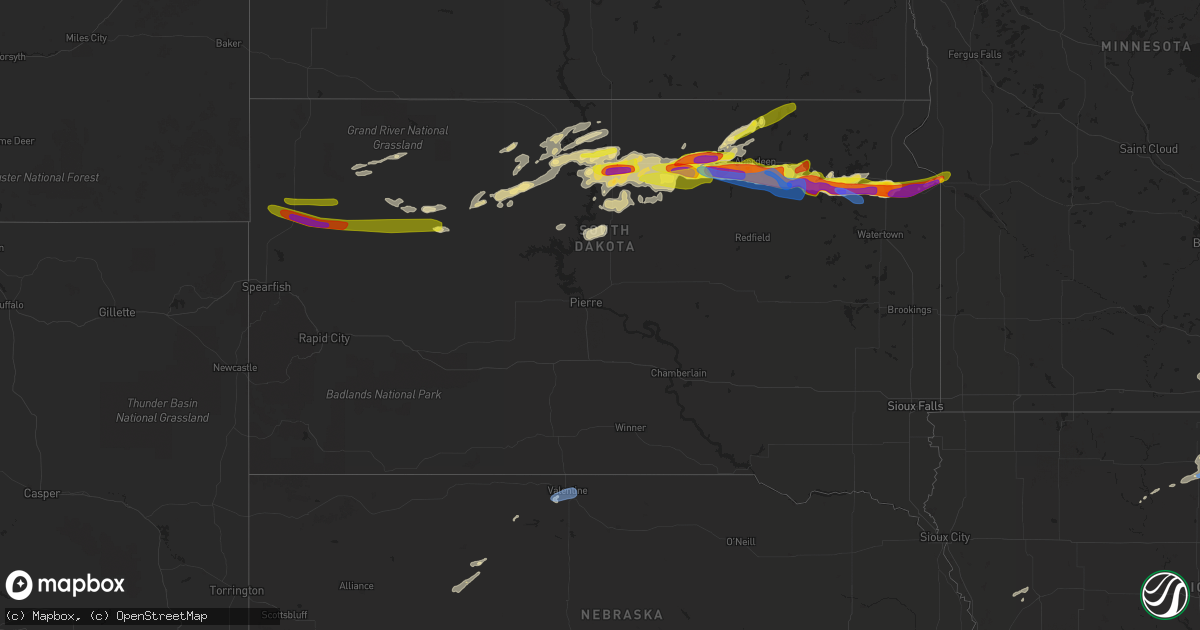
Hail Map in South Dakota on August 27, 2021
Get this storm
August 27 map
$229
one time, instant access
Download today. No call, no setup
Keep the $229
Bought the map and want the full workflow? Apply the entire $229 to a subscription within 7 days. None of it is wasted.
Every map, not just this one
This buys you this map. Subscription and you get every map we run, in the markets you choose from a few cities to whole states to nationwide. Plus real-time alerts the moment a storm fires.
Contact data
Name, contact info, occupancy, even credit band for addresses in the footprint. You go from where it hit to who to call.
Become the source they trust
Unlimited branding weather history reports on demand. You already have the documented answer ready for the property owner, and you are the one who showed up with it.
Property data and RoofTrace estimates
Pull up any address you have got, its value and the exact code rules for that jurisdiction, straight from One Click Code. Then RoofTrace estimates the squares, pitch, and roof value, priced the way you price.
Storm reports in South Dakota
South Dakota
| Date | Description |
|---|---|
| 08/27/20216:42 PM CDT | A local report indicates 1.00 inch wind near 1 WNW HOOVER |
| 08/27/20216:42 PM CDT | A local report indicates 70 MPH wind near 1 WNW HOOVER |
| 08/27/20216:20 PM CDT | Time estimated |
| 08/27/20217:34 AM CDT | At 1233 AM CDT, severe thunderstorms were located along a line extending from near Newton Hills State Park to near Alcester to 6 miles west of Akron, moving east at 40 mph. HAZARD...70 mph wind gusts. SOURCE...Radar indicated. IMPACT...Expect considerable tree damage. Damage is likely to mobile homes, roofs, and outbuildings. Severe thunderstorms will be near... Hawarden around 1240 AM CDT. Fairview around 1245 AM CDT. Hudson around 1250 AM CDT.Other locations in the path of these severe thunderstorms includeIreton, Rock Valley, Craig, Sioux Center, Maurice, Struble, Le Mars,Orange City, Hull, Alton and Boyden. |
| 08/27/20217:17 AM CDT | At 1216 AM CDT, a pair of severe thunderstorms were located near Fairview, or 10 miles southeast of Canton, moving northeast at 50 mph. HAZARD...60 mph wind gusts and quarter size hail. SOURCE...Radar indicated. IMPACT...Hail damage to vehicles is expected. Expect wind damage to roofs, siding, and trees. This severe thunderstorm will be near... Rock Valley around 1220 AM CDT. Alvord around 1225 AM CDT. Doon around 1230 AM CDT. Rock Rapids around 1235 AM CDT.Other locations in the path of these severe thunderstorms include George. |
| 08/27/20217:08 AM CDT | At 1208 AM CDT, severe thunderstorms were located along a line extending from near Davis to near Centerville to 6 miles southeast of Wakonda, moving east at 35 mph. HAZARD...70 mph wind gusts. SOURCE...Radar indicated. IMPACT...Expect considerable tree damage. Damage is likely to mobile homes, roofs, and outbuildings. Severe thunderstorms will be near... Beresford around 1220 AM CDT. Union Grove State Park around 1225 AM CDT.Other locations in the path of these severe thunderstorms includeAlcester. |
| 08/27/20216:50 AM CDT | Time estimated based on radar. |
| 08/27/20216:03 AM CDT | Golf ball sized hail is ongoing. |
| 08/27/20215:44 AM CDT | Picture of hail of 2 inches in diameter. Mentioned that some were a little larger. There was also a large tree limb down and windshields broken just west of town. |
| 08/27/20214:34 AM CDT | Hailing for the last 10 minutes. |
| 08/27/20214:30 AM CDT | A local report indicates 1.50 inch wind near 6 W WARNER |
| 08/27/20214:13 AM CDT | A local report indicates 58 MPH wind near 4 SSE WITTEN |
| 08/27/20214:08 AM CDT | Measured tennis ball sized hail. Several windows broken on house. Hail is covering the ground. |
| 08/27/20214:00 AM CDT | 50 mph or stronger winds. |
| 08/27/20213:48 AM CDT | 10 windows destroyed. |
| 08/27/20213:25 AM CDT | A local report indicates 1.00 inch wind near 4 N CRAVENS CORNER |
| 08/27/20213:20 AM CDT | A local report indicates 1.00 inch wind near 3 S ROSCOE |
| 08/27/20212:32 AM CDT | Numerous hailstones up to tennis ball sized and decreased to golf ball sized before ending. Ground was white with hail. |
| 08/27/20211:56 AM CDT | A local report indicates 1.00 inch wind near 3 NNE SELBY |
| 08/27/20211:35 AM CDT | A local report indicates 1.25 inch wind near GLENHAM |
| 08/27/202112:39 AM CDT | At 539 PM MDT, a severe thunderstorm was located 3 miles southeast of Hoover, or 38 miles southeast of Buffalo, moving east at 45 mph. HAZARD...Tennis ball size hail and 60 mph wind gusts. SOURCE...Radar indicated. IMPACT...People and animals outdoors will be injured. Expect hail damage to roofs, siding, windows, and vehicles. Expect wind damage to roofs, siding, and trees. This severe thunderstorm will be near... Zeona around 555 PM MDT.Other locations in the path of this severe thunderstorm include MudButte, Maurine, Durkee Lake, Arrow Head Buttes and Faith. |
| 08/26/20218:44 PM CDT | At 144 AM CDT, severe thunderstorms were located along a line extending from near Agar to 7 miles east of Canning, moving northeast at 35 mph. HAZARD...60 mph wind gusts and quarter size hail. SOURCE...Radar indicated. IMPACT...Hail damage to vehicles is expected. Expect wind damage to roofs, siding, and trees. Severe thunderstorms will be near... Agar around 150 AM CDT. Cottonwood Lake Near Agar around 200 AM CDT.Other locations in the path of these severe thunderstorms includeHarrold, Holabird, Stone Lake and Highmore. |
| 08/26/20218:06 PM CDT | At 106 AM CDT/1206 AM MDT/, a severe thunderstorm was located near Okobojo Point Rec Area, or 14 miles northwest of Fort Pierre, moving northeast at 40 mph. HAZARD...60 mph wind gusts and quarter size hail. SOURCE...Radar indicated. IMPACT...Hail damage to vehicles is expected. Expect wind damage to roofs, siding, and trees. This severe thunderstorm will be near... Cow Creek Rec Area, Okobojo Point Rec Area and Spring Creek Rec Area around 110 AM CDT. Grey Goose around 115 AM CDT.Other locations in the path of this severe thunderstorm include SullyLake, Onida and Agar. |
| 08/26/20217:30 PM CDT | A local report indicates 60 MPH wind near 10 ESE ZEONA |
All States Impacted by Hail Map on August 27, 2021
Cities Impacted by Hail Map on August 27, 2021
- Webster, SD
- Bristol, SD
- Branch, MI
- Baldwin, MI
- Chase, MI
- Paris, MI
- Bitely, MI
- Reed City, MI
- Idlewild, MI
- Postville, IA
- Rio, WI
- Poynette, WI
- Columbus, WI
- Randolph, WI
- Arlington, WI
- Doylestown, WI
- Fox Lake, WI
- Fall River, WI
- Deforest, WI
- Beaver Dam, WI
- Sadieville, KY
- Corinth, KY
- Socorro, NM
- Yutan, NE
- Ashland, NE
- Mansfield, SD
- Aberdeen, SD
- Datil, NM
- Omaha, NE
- Almond, WI
- Wild Rose, WI
- Superior, NE
- Mankato, KS
- Webber, KS
- Hardy, NE
- Watford City, ND
- Arnegard, ND
- Keene, ND
- New Town, ND
- Mandaree, ND
- Eagle Butte, SD
- Trail City, SD
- Prairie Du Chien, WI
- Bagley, WI
- Hanlontown, IA
- Northwood, IA
- Lake Mills, IA
- Kensett, IA
- Joice, IA
- Marvin, SD
- Summit, SD
- South Shore, SD
- Marble Rock, IA
- Greene, IA
- Rockwell, IA
- Rockford, IA
- Dougherty, IA
- Charles City, IA
- Manistee, MI
- Hoven, SD
- Ipswich, SD
- Central City, NE
- Big Rapids, MI
- Valley, NE
- Arlington, NE
- Faith, SD
- Mason City, IA
- Plymouth, IA
- Manly, IA
- Benson, AZ
- Nelson, NE
- Lawrence, NE
- Oak, NE
- Belvidere, NE
- Narka, KS
- Mahaska, KS
- Belleville, KS
- Munden, KS
- Bruning, NE
- Strang, NE
- Wisconsin Rapids, WI
- Gettysburg, SD
- Agar, SD
- Milbank, SD
- Big Stone City, SD
- Prairie City, SD
- Reva, SD
- Wakpala, SD
- McLaughlin, SD
- Shell Rock, IA
- Clarksville, IA
- Warner, SD
- Roscoe, SD
- Java, SD
- Selby, SD
- Dupree, SD
- Bowdle, SD
- Ortonville, MN
- Waupaca, WI
- Amherst, WI
- Ortley, SD
- Lomira, WI
- Theresa, WI
- Campbellsport, WI
- Mazomanie, WI
- Carleton, NE
- Eau Claire, WI
- Valentine, NE
- Oshkosh, WI
- Winneconne, WI
- Barnard, SD
- Frederick, SD
- Westport, SD
- Leola, SD
- Kennard, NE
- Fremont, NE
- Waterloo, NE
- Bennington, NE
- Hayfield, MN
- Waltham, MN
- Blooming Prairie, MN
- New Hampton, IA
- Casa Blanca, NM
- Cubero, NM
- Parkersburg, IA
- Aplington, IA
- Glenham, SD
- Mobridge, SD
- Ventura, IA
- Garner, IA
- Rock Springs, WI
- Wykoff, MN
- Chatfield, MN
- Larslan, MT
- Calmar, IA
- Ossian, IA
- Decorah, IA
- Mitchell, IN
- Lawler, IA
- Waucoma, IA
- Stratford, SD
- Elkhorn, NE
- Black Creek, WI
- Seymour, WI
- Goodell, IA
- Farmersburg, IA
- Marquette, IA
- McGregor, IA
- Shickley, NE
- Waubay, SD
- Riceville, IA
- Mound City, SD
- Trempealeau, WI
- Dover, MN
- Rollingstone, MN
- Winona, MN
- Lewiston, MN
- Minnesota City, MN
- Utica, MN
- Saint Charles, MN
- Ettrick, WI
- Blair, WI
- Arcadia, WI
- Eyota, MN
- Altura, MN
- Dodge, WI
- Fountain City, WI
- Galesville, WI
- Chilton, WI
- Corona, NM
- Pulaski, WI
- Merriman, NE
- Salyersville, KY
- Phenix City, AL
- Fort Benning, GA
- Aurora, NE
- Hampton, NE
- Timber Lake, SD
- Stephen, MN
- Andover, SD
- Groton, SD
- Conde, SD
- Bath, SD
- Onaka, SD
- Tolstoy, SD
- Rosendale, WI
- Monona, IA
- Eastman, WI
- Harpers Ferry, IA
- Orchard, IA
- Floyd, IA
- Gilead, NE
- Alexandria, NE
- Livermore, IA
- Humboldt, IA
- Wellston, MI
- Osage, IA
- Little Cedar, IA
- Archer, NE
- Alamo, ND
- Luther, MI
- Irons, MI
- Republic, KS
- Byron, NE
- Grinnell, KS
- Custer, MI
- Newport, KY
- Elma, IA
- Hubbell, NE
- Haddam, KS
- Cuba, KS
- Browder, KY
- Drakesboro, KY
- Belton, KY
- Alta Vista, IA
- Milladore, WI
- Auburndale, WI
- Mosinee, WI
- Stratford, WI
- Clarks, NE
- Walkerville, MI
- Masonville, IA
- Edgewood, NM
- Tijeras, NM
- Alexandria, KY
- Morning View, KY
- Independence, KY
- Latonia, KY
- Horicon, WI
- Jonesville, IN
- Columbus, IN
- Marquette, NE
- Hyannis, NE
- Sauk City, WI
- Swanton, NE
- De Witt, NE
- Central City, KY
- Weyauwega, WI
- Fremont, WI
- Pine River, WI
- Hollandale, MN
- Clarks Grove, MN
- Albert Lea, MN
- Ellendale, MN
- Westminster, MD
- Epping, ND
- Canton, PA
- Juneau, WI
- Zumbro Falls, MN
- Fairbury, NE
- Florence, AZ
- Isabel, SD
- Neillsville, WI
- Lewisburg, KY
- Milmay, NJ
- Zahl, ND
- Oelwein, IA
- Edwardsville, IL
- Ohiowa, NE
- Oxford, WI
- Green Bay, WI
- Granton, WI
- Chili, WI
- Bloomington, WI
- Mount Hope, WI
- Luana, IA
- Birdseye, IN
- Fredericksburg, IA
- Thornton, IA
- Nashua, IA
- Ionia, IA
- Swaledale, IA
- Clear Lake, IA
- Saint Ansgar, IA
- Butte Des Morts, WI
- Omro, WI
- Neenah, WI
- Berlin, WI
- Larsen, WI
- Henderson, KY
- Dow City, IA
- Grafton, IA
- Grand Island, NE
- Cairo, NE
- Hartland, MN
- New Richland, MN
- Freeborn, MN
- Wells, MN
- Alden, MN
- West Bend, WI
- Hartford, WI
- Allenton, WI
- Iron Ridge, WI
- Mayville, WI
- Maynard, IA
- Westgate, IA
- Edgewater, MD
- Annapolis, MD
- Louisville, IL
- Akaska, SD
- Ferney, SD
- Pollock, SD
- Williston, ND
- Chapman, NE
- Elkhart Lake, WI
- Kiel, WI
- Paris, KY
- Lawrenceburg, KY
- Evart, MI
- Magdalena, NM
- Shiocton, WI
- Bonduel, WI
- Meservey, IA
- Glenville, MN
- Sheffield, IA
- Alexander, IA
- Fertile, IA
- Forest City, IA
- Kanawha, IA
- Klemme, IA
- Nora Springs, IA
- Fort Atkinson, IA
- Britt, IA
- Rock Falls, IA
- Belmond, IA
- Hayward, MN
- Cambria, WI
- Brandenburg, KY
- Waldorf, MD
- Eden, WI
- Woodman, WI
- Garnavillo, IA
- Rutland, IA
- Hawkeye, IA
- Blairstown, NJ
- Edinburgh, IN
- Bison, SD
- Glen Carbon, IL
- Bethel, OH
- Georgetown, OH
- Meadow, SD
- Alma Center, WI
- Fairchild, WI
- Wilber, NE
- McIntosh, SD
- Castalia, IA
- Cross Plains, IN
- Versailles, IN
- Saint Libory, NE
- Spring Green, WI
- Bear Creek, WI
- Clifton, AZ
- San Carlos, AZ
- Mount Orab, OH
- Hamersville, OH
- Potomac, MD
- Great Falls, VA
- Rockville, MD
- Fort Calhoun, NE
- Dawson, GA
- Courtland, KS
- Owensboro, KY
- Greenville, KY
- Ithaca, NE
- Clintonville, WI
- Hebron, NE
- Deshler, NE
- Woodbridge, VA
- Dumfries, VA
- Tucson, AZ
- Vail, AZ
- Felton, DE
- Greensboro, MD
- Harrington, DE
- Whitman, NE
- Rochester, MN
- Burnett, WI
- Plymouth, WI
- Glenbeulah, WI
- Union Bridge, MD
- Lamont, IA
- Dundee, IA
- Aurora, IA
- Independence, IA
- Hazleton, IA
- Arlington, IA
- Winthrop, IA
- Stanley, IA
- Strawberry Point, IA
- Grundy Center, IA
- Salvisa, KY
- Fallston, MD
- Sparks Glencoe, MD
- Phoenix, MD
- Baldwin, MD
- Monkton, MD
- Lebanon, KY
- Marshfield, WI
- Highland, WI
- Dodgeville, WI
- Arena, WI
- West Union, IA
- Saint Lucas, IA
- Edgar, NE
- New Providence, PA
- Willow Street, PA
- Strasburg, PA
- Greenfield, IL
- Palmyra, IL
- Renwick, IA
- Harrodsburg, KY
- Seymour, IN
- Bedford, IN
- Boonville, IN
- Butler, KY
- Vinton, VA
- Hardy, VA
- Missouri Valley, IA
- Honey Creek, IA
- Glencross, SD
- Phillipsburg, NJ
- Plover, WI
- Sells, AZ
- Jansen, NE
- Ute, IA
- Denison, IA
- Charter Oak, IA
- Chrisney, IN
- Santa Claus, IN
- Winchester, KY
- Merrillan, WI
- Sumner, IA
- Leroy, MI
- Tustin, MI
- Washington, NE
- Karlstad, MN
- Lodi, WI
- Dane, WI
- Avoca, WI
- Fairbank, IA
- Gilboa, NY
- Stamford, NY
- Grand Gorge, NY
- Hartford City, IN
- Latimer, IA
- Patch Grove, WI
- Clermont, IA
- Cross Plains, WI
- Barneveld, WI
- Blue Mounds, WI
- Black Earth, WI
- Ridgeway, WI
- Richland Center, WI
- Blue River, WI
- Muscoda, WI
- Soldiers Grove, WI
- Lone Rock, WI
- Mellette, SD
- Brentford, SD
- Florence, SD
- Newell, SD
- Belle Fourche, SD
- Mud Butte, SD
- Twin Brooks, SD
- Corona, SD
- Columbia, SD
- Hecla, SD
- Silver Spring, MD
- Garrett Park, MD
- Kensington, MD
- Bethesda, MD
- Chevy Chase, MD
- Blair, NE
- Richland, MT


