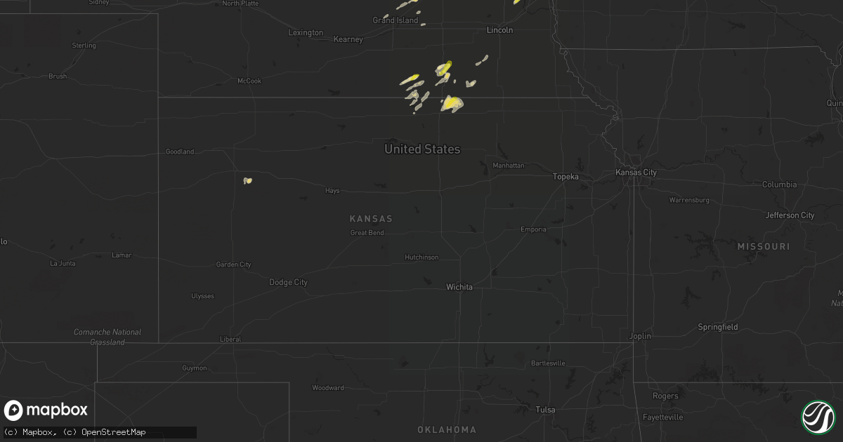
Hail Map in Kansas on August 27, 2021
Get this storm
August 27 map
$229
one time, instant access
Download today. No call, no setup
Keep the $229
Bought the map and want the full workflow? Apply the entire $229 to a subscription within 7 days. None of it is wasted.
Every map, not just this one
This buys you this map. Subscription and you get every map we run, in the markets you choose from a few cities to whole states to nationwide. Plus real-time alerts the moment a storm fires.
Contact data
Name, contact info, occupancy, even credit band for addresses in the footprint. You go from where it hit to who to call.
Become the source they trust
Unlimited branding weather history reports on demand. You already have the documented answer ready for the property owner, and you are the one who showed up with it.
Property data and RoofTrace estimates
Pull up any address you have got, its value and the exact code rules for that jurisdiction, straight from One Click Code. Then RoofTrace estimates the squares, pitch, and roof value, priced the way you price.
Storm reports in Kansas
Kansas
| Date | Description |
|---|---|
| 08/27/20215:15 PM CDT | Delayed report. Microburst winds blew the roof off a large farm equipment shelter. Time is estimated based on radar and homeowner. Winds estimated to be around 75 mph. |
| 08/27/202112:15 AM CDT | At 515 PM CDT, a severe thunderstorm was located near Narka, moving northeast at 20 mph. This warning replaces the severe thunderstorm warning that was set to expire at 515 PM. HAZARD...60 mph wind gusts and penny size hail. SOURCE...Radar indicated. IMPACT...Expect damage to roofs, siding, and trees. Locations impacted include... Narka and Mahaska. |
| 08/26/202111:27 PM CDT | At 427 PM CDT, a severe thunderstorm was located near Munden, moving northeast at 20 mph. HAZARD...60 mph wind gusts. SOURCE...Radar indicated. IMPACT...Expect damage to roofs, siding, and trees. Locations impacted include... Munden, Narka and Mahaska. |
All States Impacted by Hail Map on August 27, 2021
Cities Impacted by Hail Map on August 27, 2021
- Webster, SD
- Bristol, SD
- Branch, MI
- Baldwin, MI
- Chase, MI
- Paris, MI
- Bitely, MI
- Reed City, MI
- Idlewild, MI
- Postville, IA
- Rio, WI
- Poynette, WI
- Columbus, WI
- Randolph, WI
- Arlington, WI
- Doylestown, WI
- Fox Lake, WI
- Fall River, WI
- Deforest, WI
- Beaver Dam, WI
- Sadieville, KY
- Corinth, KY
- Socorro, NM
- Yutan, NE
- Ashland, NE
- Mansfield, SD
- Aberdeen, SD
- Datil, NM
- Omaha, NE
- Almond, WI
- Wild Rose, WI
- Superior, NE
- Mankato, KS
- Webber, KS
- Hardy, NE
- Watford City, ND
- Arnegard, ND
- Keene, ND
- New Town, ND
- Mandaree, ND
- Eagle Butte, SD
- Trail City, SD
- Prairie Du Chien, WI
- Bagley, WI
- Hanlontown, IA
- Northwood, IA
- Lake Mills, IA
- Kensett, IA
- Joice, IA
- Marvin, SD
- Summit, SD
- South Shore, SD
- Marble Rock, IA
- Greene, IA
- Rockwell, IA
- Rockford, IA
- Dougherty, IA
- Charles City, IA
- Manistee, MI
- Hoven, SD
- Ipswich, SD
- Central City, NE
- Big Rapids, MI
- Valley, NE
- Arlington, NE
- Faith, SD
- Mason City, IA
- Plymouth, IA
- Manly, IA
- Benson, AZ
- Nelson, NE
- Lawrence, NE
- Oak, NE
- Belvidere, NE
- Narka, KS
- Mahaska, KS
- Belleville, KS
- Munden, KS
- Bruning, NE
- Strang, NE
- Wisconsin Rapids, WI
- Gettysburg, SD
- Agar, SD
- Milbank, SD
- Big Stone City, SD
- Prairie City, SD
- Reva, SD
- Wakpala, SD
- McLaughlin, SD
- Shell Rock, IA
- Clarksville, IA
- Warner, SD
- Roscoe, SD
- Java, SD
- Selby, SD
- Dupree, SD
- Bowdle, SD
- Ortonville, MN
- Waupaca, WI
- Amherst, WI
- Ortley, SD
- Lomira, WI
- Theresa, WI
- Campbellsport, WI
- Mazomanie, WI
- Carleton, NE
- Eau Claire, WI
- Valentine, NE
- Oshkosh, WI
- Winneconne, WI
- Barnard, SD
- Frederick, SD
- Westport, SD
- Leola, SD
- Kennard, NE
- Fremont, NE
- Waterloo, NE
- Bennington, NE
- Hayfield, MN
- Waltham, MN
- Blooming Prairie, MN
- New Hampton, IA
- Casa Blanca, NM
- Cubero, NM
- Parkersburg, IA
- Aplington, IA
- Glenham, SD
- Mobridge, SD
- Ventura, IA
- Garner, IA
- Rock Springs, WI
- Wykoff, MN
- Chatfield, MN
- Larslan, MT
- Calmar, IA
- Ossian, IA
- Decorah, IA
- Mitchell, IN
- Lawler, IA
- Waucoma, IA
- Stratford, SD
- Elkhorn, NE
- Black Creek, WI
- Seymour, WI
- Goodell, IA
- Farmersburg, IA
- Marquette, IA
- McGregor, IA
- Shickley, NE
- Waubay, SD
- Riceville, IA
- Mound City, SD
- Trempealeau, WI
- Dover, MN
- Rollingstone, MN
- Winona, MN
- Lewiston, MN
- Minnesota City, MN
- Utica, MN
- Saint Charles, MN
- Ettrick, WI
- Blair, WI
- Arcadia, WI
- Eyota, MN
- Altura, MN
- Dodge, WI
- Fountain City, WI
- Galesville, WI
- Chilton, WI
- Corona, NM
- Pulaski, WI
- Merriman, NE
- Salyersville, KY
- Phenix City, AL
- Fort Benning, GA
- Aurora, NE
- Hampton, NE
- Timber Lake, SD
- Stephen, MN
- Andover, SD
- Groton, SD
- Conde, SD
- Bath, SD
- Onaka, SD
- Tolstoy, SD
- Rosendale, WI
- Monona, IA
- Eastman, WI
- Harpers Ferry, IA
- Orchard, IA
- Floyd, IA
- Gilead, NE
- Alexandria, NE
- Livermore, IA
- Humboldt, IA
- Wellston, MI
- Osage, IA
- Little Cedar, IA
- Archer, NE
- Alamo, ND
- Luther, MI
- Irons, MI
- Republic, KS
- Byron, NE
- Grinnell, KS
- Custer, MI
- Newport, KY
- Elma, IA
- Hubbell, NE
- Haddam, KS
- Cuba, KS
- Browder, KY
- Drakesboro, KY
- Belton, KY
- Alta Vista, IA
- Milladore, WI
- Auburndale, WI
- Mosinee, WI
- Stratford, WI
- Clarks, NE
- Walkerville, MI
- Masonville, IA
- Edgewood, NM
- Tijeras, NM
- Alexandria, KY
- Morning View, KY
- Independence, KY
- Latonia, KY
- Horicon, WI
- Jonesville, IN
- Columbus, IN
- Marquette, NE
- Hyannis, NE
- Sauk City, WI
- Swanton, NE
- De Witt, NE
- Central City, KY
- Weyauwega, WI
- Fremont, WI
- Pine River, WI
- Hollandale, MN
- Clarks Grove, MN
- Albert Lea, MN
- Ellendale, MN
- Westminster, MD
- Epping, ND
- Canton, PA
- Juneau, WI
- Zumbro Falls, MN
- Fairbury, NE
- Florence, AZ
- Isabel, SD
- Neillsville, WI
- Lewisburg, KY
- Milmay, NJ
- Zahl, ND
- Oelwein, IA
- Edwardsville, IL
- Ohiowa, NE
- Oxford, WI
- Green Bay, WI
- Granton, WI
- Chili, WI
- Bloomington, WI
- Mount Hope, WI
- Luana, IA
- Birdseye, IN
- Fredericksburg, IA
- Thornton, IA
- Nashua, IA
- Ionia, IA
- Swaledale, IA
- Clear Lake, IA
- Saint Ansgar, IA
- Butte Des Morts, WI
- Omro, WI
- Neenah, WI
- Berlin, WI
- Larsen, WI
- Henderson, KY
- Dow City, IA
- Grafton, IA
- Grand Island, NE
- Cairo, NE
- Hartland, MN
- New Richland, MN
- Freeborn, MN
- Wells, MN
- Alden, MN
- West Bend, WI
- Hartford, WI
- Allenton, WI
- Iron Ridge, WI
- Mayville, WI
- Maynard, IA
- Westgate, IA
- Edgewater, MD
- Annapolis, MD
- Louisville, IL
- Akaska, SD
- Ferney, SD
- Pollock, SD
- Williston, ND
- Chapman, NE
- Elkhart Lake, WI
- Kiel, WI
- Paris, KY
- Lawrenceburg, KY
- Evart, MI
- Magdalena, NM
- Shiocton, WI
- Bonduel, WI
- Meservey, IA
- Glenville, MN
- Sheffield, IA
- Alexander, IA
- Fertile, IA
- Forest City, IA
- Kanawha, IA
- Klemme, IA
- Nora Springs, IA
- Fort Atkinson, IA
- Britt, IA
- Rock Falls, IA
- Belmond, IA
- Hayward, MN
- Cambria, WI
- Brandenburg, KY
- Waldorf, MD
- Eden, WI
- Woodman, WI
- Garnavillo, IA
- Rutland, IA
- Hawkeye, IA
- Blairstown, NJ
- Edinburgh, IN
- Bison, SD
- Glen Carbon, IL
- Bethel, OH
- Georgetown, OH
- Meadow, SD
- Alma Center, WI
- Fairchild, WI
- Wilber, NE
- McIntosh, SD
- Castalia, IA
- Cross Plains, IN
- Versailles, IN
- Saint Libory, NE
- Spring Green, WI
- Bear Creek, WI
- Clifton, AZ
- San Carlos, AZ
- Mount Orab, OH
- Hamersville, OH
- Potomac, MD
- Great Falls, VA
- Rockville, MD
- Fort Calhoun, NE
- Dawson, GA
- Courtland, KS
- Owensboro, KY
- Greenville, KY
- Ithaca, NE
- Clintonville, WI
- Hebron, NE
- Deshler, NE
- Woodbridge, VA
- Dumfries, VA
- Tucson, AZ
- Vail, AZ
- Felton, DE
- Greensboro, MD
- Harrington, DE
- Whitman, NE
- Rochester, MN
- Burnett, WI
- Plymouth, WI
- Glenbeulah, WI
- Union Bridge, MD
- Lamont, IA
- Dundee, IA
- Aurora, IA
- Independence, IA
- Hazleton, IA
- Arlington, IA
- Winthrop, IA
- Stanley, IA
- Strawberry Point, IA
- Grundy Center, IA
- Salvisa, KY
- Fallston, MD
- Sparks Glencoe, MD
- Phoenix, MD
- Baldwin, MD
- Monkton, MD
- Lebanon, KY
- Marshfield, WI
- Highland, WI
- Dodgeville, WI
- Arena, WI
- West Union, IA
- Saint Lucas, IA
- Edgar, NE
- New Providence, PA
- Willow Street, PA
- Strasburg, PA
- Greenfield, IL
- Palmyra, IL
- Renwick, IA
- Harrodsburg, KY
- Seymour, IN
- Bedford, IN
- Boonville, IN
- Butler, KY
- Vinton, VA
- Hardy, VA
- Missouri Valley, IA
- Honey Creek, IA
- Glencross, SD
- Phillipsburg, NJ
- Plover, WI
- Sells, AZ
- Jansen, NE
- Ute, IA
- Denison, IA
- Charter Oak, IA
- Chrisney, IN
- Santa Claus, IN
- Winchester, KY
- Merrillan, WI
- Sumner, IA
- Leroy, MI
- Tustin, MI
- Washington, NE
- Karlstad, MN
- Lodi, WI
- Dane, WI
- Avoca, WI
- Fairbank, IA
- Gilboa, NY
- Stamford, NY
- Grand Gorge, NY
- Hartford City, IN
- Latimer, IA
- Patch Grove, WI
- Clermont, IA
- Cross Plains, WI
- Barneveld, WI
- Blue Mounds, WI
- Black Earth, WI
- Ridgeway, WI
- Richland Center, WI
- Blue River, WI
- Muscoda, WI
- Soldiers Grove, WI
- Lone Rock, WI
- Mellette, SD
- Brentford, SD
- Florence, SD
- Newell, SD
- Belle Fourche, SD
- Mud Butte, SD
- Twin Brooks, SD
- Corona, SD
- Columbia, SD
- Hecla, SD
- Silver Spring, MD
- Garrett Park, MD
- Kensington, MD
- Bethesda, MD
- Chevy Chase, MD
- Blair, NE
- Richland, MT


