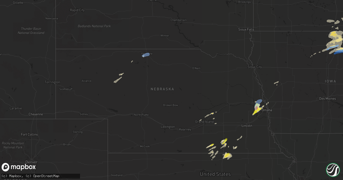
Hail Map in Nebraska on August 27, 2021
Get this storm
August 27 map
$229
one time, instant access
Download today. No call, no setup
Keep the $229
Bought the map and want the full workflow? Apply the entire $229 to a subscription within 7 days. None of it is wasted.
Every map, not just this one
This buys you this map. Subscription and you get every map we run, in the markets you choose from a few cities to whole states to nationwide. Plus real-time alerts the moment a storm fires.
Contact data
Name, contact info, occupancy, even credit band for addresses in the footprint. You go from where it hit to who to call.
Become the source they trust
Unlimited branding weather history reports on demand. You already have the documented answer ready for the property owner, and you are the one who showed up with it.
Property data and RoofTrace estimates
Pull up any address you have got, its value and the exact code rules for that jurisdiction, straight from One Click Code. Then RoofTrace estimates the squares, pitch, and roof value, priced the way you price.
Storm reports in Nebraska
Nebraska
| Date | Description |
|---|---|
| 08/27/20216:45 PM CDT | A local report indicates 1.00 inch wind near 4 N NELSON |
| 08/27/20216:43 PM CDT | Hail the size of ping pong balls was observed at nws omaha. |
| 08/27/20216:40 PM CDT | Peak wind gust of 60 mph was measured at nws omaha. |
| 08/27/20216:37 PM CDT | Caller reported 2 hailstone. |
| 08/27/20216:36 PM CDT | Report passed along by broadcast media. Time estimated based on radar data. |
| 08/27/20216:28 PM CDT | Corrects previous hail report from 2 ene elkhorn. Located at 175th and maple. |
| 08/27/20216:22 PM CDT | Corrects previous hail report from yutan. Report from twitter. |
| 08/27/20216:07 PM CDT | Nws employee sent in picture of hail the size of quarters. |
| 08/27/20215:50 PM CDT | A local report indicates 1.25 inch wind near BRUNING |
| 08/27/20214:31 PM CDT | Metal shed/garage blown down report via twitter. |
| 08/27/20213:45 AM CDT | A local report indicates 62 MPH wind near 1 ENE VALENTINE |
| 08/27/20213:39 AM CDT | A local report indicates 63 MPH wind near VALENTINE |
| 08/27/20212:26 AM CDT | Heat burst observed by kvtn asos. Thundershowers in the vicinity. |
| 08/27/20211:54 AM CDT | At 654 PM CDT, a severe thunderstorm was located near Oak, or 30 miles southeast of Hastings, moving northeast at 30 mph. HAZARD...Quarter size hail. SOURCE...Trained weather spotters. IMPACT...Damage to vehicles is expected. This severe thunderstorm will be near... Edgar around 700 PM CDT. Davenport around 710 PM CDT.Other locations in the path of this severe thunderstorm include Ong,Shickley and Carleton. |
| 08/27/20211:43 AM CDT | At 640 PM CDT, a severe thunderstorm was located over Valley, or 18 miles west of Omaha, moving north at 15 mph. HAZARD...Two inch hail and 60 mph wind gusts. SOURCE...Trained weather spotters. IMPACT...People and animals outdoors will be injured. Expect hail damage to roofs, siding, windows, and vehicles. Expect wind damage to roofs, siding, and trees. Locations impacted include... Arlington. |
| 08/27/20211:41 AM CDT | At 639 PM CDT, a severe thunderstorm was located over Valley, or 18 miles west of Omaha, moving north at 15 mph. HAZARD...Two inch hail and 60 mph wind gusts. SOURCE...Trained weather spotters. Two inch hail was reported in Valley, and a 60 mph wind gust was reported at the Weather Service Office. IMPACT...People and animals outdoors will be injured. Expect hail damage to roofs, siding, windows, and vehicles. Expect wind damage to roofs, siding, and trees. Locations impacted include... Arlington. |
| 08/27/20211:04 AM CDT | At 604 PM CDT, a severe thunderstorm was located over Yutan, or 17 miles west of Omaha, moving northeast at 25 mph. HAZARD...Ping pong ball size hail and 60 mph wind gusts. SOURCE...Radar indicated. IMPACT...People and animals outdoors will be injured. Expect hail damage to roofs, siding, windows, and vehicles. Expect wind damage to roofs, siding, and trees. This severe thunderstorm will be near... Valley around 615 PM CDT. Waterloo around 620 PM CDT.Other locations in the path of this severe thunderstorm includeElkhorn. |
| 08/27/202112:57 AM CDT | At 557 PM CDT, a severe thunderstorm was located near Bruning, or 35 miles south of York, moving northeast at 20 mph. HAZARD...Half dollar size hail near Bruning at 550 PM. SOURCE...Trained weather spotters. IMPACT...Damage to vehicles is expected. This severe thunderstorm will be near... Ohiowa around 610 PM CDT.Other locations in the path of this severe thunderstorm includeMilligan. |
| 08/26/20217:11 PM CDT | Report from mping: 3-inch tree limbs broken; power poles broken. |
| 08/26/20217:07 PM CDT | 60 mph measured from mesonet site up342. |
All States Impacted by Hail Map on August 27, 2021
Cities Impacted by Hail Map on August 27, 2021
- Webster, SD
- Bristol, SD
- Branch, MI
- Baldwin, MI
- Chase, MI
- Paris, MI
- Bitely, MI
- Reed City, MI
- Idlewild, MI
- Postville, IA
- Rio, WI
- Poynette, WI
- Columbus, WI
- Randolph, WI
- Arlington, WI
- Doylestown, WI
- Fox Lake, WI
- Fall River, WI
- Deforest, WI
- Beaver Dam, WI
- Sadieville, KY
- Corinth, KY
- Socorro, NM
- Yutan, NE
- Ashland, NE
- Mansfield, SD
- Aberdeen, SD
- Datil, NM
- Omaha, NE
- Almond, WI
- Wild Rose, WI
- Superior, NE
- Mankato, KS
- Webber, KS
- Hardy, NE
- Watford City, ND
- Arnegard, ND
- Keene, ND
- New Town, ND
- Mandaree, ND
- Eagle Butte, SD
- Trail City, SD
- Prairie Du Chien, WI
- Bagley, WI
- Hanlontown, IA
- Northwood, IA
- Lake Mills, IA
- Kensett, IA
- Joice, IA
- Marvin, SD
- Summit, SD
- South Shore, SD
- Marble Rock, IA
- Greene, IA
- Rockwell, IA
- Rockford, IA
- Dougherty, IA
- Charles City, IA
- Manistee, MI
- Hoven, SD
- Ipswich, SD
- Central City, NE
- Big Rapids, MI
- Valley, NE
- Arlington, NE
- Faith, SD
- Mason City, IA
- Plymouth, IA
- Manly, IA
- Benson, AZ
- Nelson, NE
- Lawrence, NE
- Oak, NE
- Belvidere, NE
- Narka, KS
- Mahaska, KS
- Belleville, KS
- Munden, KS
- Bruning, NE
- Strang, NE
- Wisconsin Rapids, WI
- Gettysburg, SD
- Agar, SD
- Milbank, SD
- Big Stone City, SD
- Prairie City, SD
- Reva, SD
- Wakpala, SD
- McLaughlin, SD
- Shell Rock, IA
- Clarksville, IA
- Warner, SD
- Roscoe, SD
- Java, SD
- Selby, SD
- Dupree, SD
- Bowdle, SD
- Ortonville, MN
- Waupaca, WI
- Amherst, WI
- Ortley, SD
- Lomira, WI
- Theresa, WI
- Campbellsport, WI
- Mazomanie, WI
- Carleton, NE
- Eau Claire, WI
- Valentine, NE
- Oshkosh, WI
- Winneconne, WI
- Barnard, SD
- Frederick, SD
- Westport, SD
- Leola, SD
- Kennard, NE
- Fremont, NE
- Waterloo, NE
- Bennington, NE
- Hayfield, MN
- Waltham, MN
- Blooming Prairie, MN
- New Hampton, IA
- Casa Blanca, NM
- Cubero, NM
- Parkersburg, IA
- Aplington, IA
- Glenham, SD
- Mobridge, SD
- Ventura, IA
- Garner, IA
- Rock Springs, WI
- Wykoff, MN
- Chatfield, MN
- Larslan, MT
- Calmar, IA
- Ossian, IA
- Decorah, IA
- Mitchell, IN
- Lawler, IA
- Waucoma, IA
- Stratford, SD
- Elkhorn, NE
- Black Creek, WI
- Seymour, WI
- Goodell, IA
- Farmersburg, IA
- Marquette, IA
- McGregor, IA
- Shickley, NE
- Waubay, SD
- Riceville, IA
- Mound City, SD
- Trempealeau, WI
- Dover, MN
- Rollingstone, MN
- Winona, MN
- Lewiston, MN
- Minnesota City, MN
- Utica, MN
- Saint Charles, MN
- Ettrick, WI
- Blair, WI
- Arcadia, WI
- Eyota, MN
- Altura, MN
- Dodge, WI
- Fountain City, WI
- Galesville, WI
- Chilton, WI
- Corona, NM
- Pulaski, WI
- Merriman, NE
- Salyersville, KY
- Phenix City, AL
- Fort Benning, GA
- Aurora, NE
- Hampton, NE
- Timber Lake, SD
- Stephen, MN
- Andover, SD
- Groton, SD
- Conde, SD
- Bath, SD
- Onaka, SD
- Tolstoy, SD
- Rosendale, WI
- Monona, IA
- Eastman, WI
- Harpers Ferry, IA
- Orchard, IA
- Floyd, IA
- Gilead, NE
- Alexandria, NE
- Livermore, IA
- Humboldt, IA
- Wellston, MI
- Osage, IA
- Little Cedar, IA
- Archer, NE
- Alamo, ND
- Luther, MI
- Irons, MI
- Republic, KS
- Byron, NE
- Grinnell, KS
- Custer, MI
- Newport, KY
- Elma, IA
- Hubbell, NE
- Haddam, KS
- Cuba, KS
- Browder, KY
- Drakesboro, KY
- Belton, KY
- Alta Vista, IA
- Milladore, WI
- Auburndale, WI
- Mosinee, WI
- Stratford, WI
- Clarks, NE
- Walkerville, MI
- Masonville, IA
- Edgewood, NM
- Tijeras, NM
- Alexandria, KY
- Morning View, KY
- Independence, KY
- Latonia, KY
- Horicon, WI
- Jonesville, IN
- Columbus, IN
- Marquette, NE
- Hyannis, NE
- Sauk City, WI
- Swanton, NE
- De Witt, NE
- Central City, KY
- Weyauwega, WI
- Fremont, WI
- Pine River, WI
- Hollandale, MN
- Clarks Grove, MN
- Albert Lea, MN
- Ellendale, MN
- Westminster, MD
- Epping, ND
- Canton, PA
- Juneau, WI
- Zumbro Falls, MN
- Fairbury, NE
- Florence, AZ
- Isabel, SD
- Neillsville, WI
- Lewisburg, KY
- Milmay, NJ
- Zahl, ND
- Oelwein, IA
- Edwardsville, IL
- Ohiowa, NE
- Oxford, WI
- Green Bay, WI
- Granton, WI
- Chili, WI
- Bloomington, WI
- Mount Hope, WI
- Luana, IA
- Birdseye, IN
- Fredericksburg, IA
- Thornton, IA
- Nashua, IA
- Ionia, IA
- Swaledale, IA
- Clear Lake, IA
- Saint Ansgar, IA
- Butte Des Morts, WI
- Omro, WI
- Neenah, WI
- Berlin, WI
- Larsen, WI
- Henderson, KY
- Dow City, IA
- Grafton, IA
- Grand Island, NE
- Cairo, NE
- Hartland, MN
- New Richland, MN
- Freeborn, MN
- Wells, MN
- Alden, MN
- West Bend, WI
- Hartford, WI
- Allenton, WI
- Iron Ridge, WI
- Mayville, WI
- Maynard, IA
- Westgate, IA
- Edgewater, MD
- Annapolis, MD
- Louisville, IL
- Akaska, SD
- Ferney, SD
- Pollock, SD
- Williston, ND
- Chapman, NE
- Elkhart Lake, WI
- Kiel, WI
- Paris, KY
- Lawrenceburg, KY
- Evart, MI
- Magdalena, NM
- Shiocton, WI
- Bonduel, WI
- Meservey, IA
- Glenville, MN
- Sheffield, IA
- Alexander, IA
- Fertile, IA
- Forest City, IA
- Kanawha, IA
- Klemme, IA
- Nora Springs, IA
- Fort Atkinson, IA
- Britt, IA
- Rock Falls, IA
- Belmond, IA
- Hayward, MN
- Cambria, WI
- Brandenburg, KY
- Waldorf, MD
- Eden, WI
- Woodman, WI
- Garnavillo, IA
- Rutland, IA
- Hawkeye, IA
- Blairstown, NJ
- Edinburgh, IN
- Bison, SD
- Glen Carbon, IL
- Bethel, OH
- Georgetown, OH
- Meadow, SD
- Alma Center, WI
- Fairchild, WI
- Wilber, NE
- McIntosh, SD
- Castalia, IA
- Cross Plains, IN
- Versailles, IN
- Saint Libory, NE
- Spring Green, WI
- Bear Creek, WI
- Clifton, AZ
- San Carlos, AZ
- Mount Orab, OH
- Hamersville, OH
- Potomac, MD
- Great Falls, VA
- Rockville, MD
- Fort Calhoun, NE
- Dawson, GA
- Courtland, KS
- Owensboro, KY
- Greenville, KY
- Ithaca, NE
- Clintonville, WI
- Hebron, NE
- Deshler, NE
- Woodbridge, VA
- Dumfries, VA
- Tucson, AZ
- Vail, AZ
- Felton, DE
- Greensboro, MD
- Harrington, DE
- Whitman, NE
- Rochester, MN
- Burnett, WI
- Plymouth, WI
- Glenbeulah, WI
- Union Bridge, MD
- Lamont, IA
- Dundee, IA
- Aurora, IA
- Independence, IA
- Hazleton, IA
- Arlington, IA
- Winthrop, IA
- Stanley, IA
- Strawberry Point, IA
- Grundy Center, IA
- Salvisa, KY
- Fallston, MD
- Sparks Glencoe, MD
- Phoenix, MD
- Baldwin, MD
- Monkton, MD
- Lebanon, KY
- Marshfield, WI
- Highland, WI
- Dodgeville, WI
- Arena, WI
- West Union, IA
- Saint Lucas, IA
- Edgar, NE
- New Providence, PA
- Willow Street, PA
- Strasburg, PA
- Greenfield, IL
- Palmyra, IL
- Renwick, IA
- Harrodsburg, KY
- Seymour, IN
- Bedford, IN
- Boonville, IN
- Butler, KY
- Vinton, VA
- Hardy, VA
- Missouri Valley, IA
- Honey Creek, IA
- Glencross, SD
- Phillipsburg, NJ
- Plover, WI
- Sells, AZ
- Jansen, NE
- Ute, IA
- Denison, IA
- Charter Oak, IA
- Chrisney, IN
- Santa Claus, IN
- Winchester, KY
- Merrillan, WI
- Sumner, IA
- Leroy, MI
- Tustin, MI
- Washington, NE
- Karlstad, MN
- Lodi, WI
- Dane, WI
- Avoca, WI
- Fairbank, IA
- Gilboa, NY
- Stamford, NY
- Grand Gorge, NY
- Hartford City, IN
- Latimer, IA
- Patch Grove, WI
- Clermont, IA
- Cross Plains, WI
- Barneveld, WI
- Blue Mounds, WI
- Black Earth, WI
- Ridgeway, WI
- Richland Center, WI
- Blue River, WI
- Muscoda, WI
- Soldiers Grove, WI
- Lone Rock, WI
- Mellette, SD
- Brentford, SD
- Florence, SD
- Newell, SD
- Belle Fourche, SD
- Mud Butte, SD
- Twin Brooks, SD
- Corona, SD
- Columbia, SD
- Hecla, SD
- Silver Spring, MD
- Garrett Park, MD
- Kensington, MD
- Bethesda, MD
- Chevy Chase, MD
- Blair, NE
- Richland, MT


