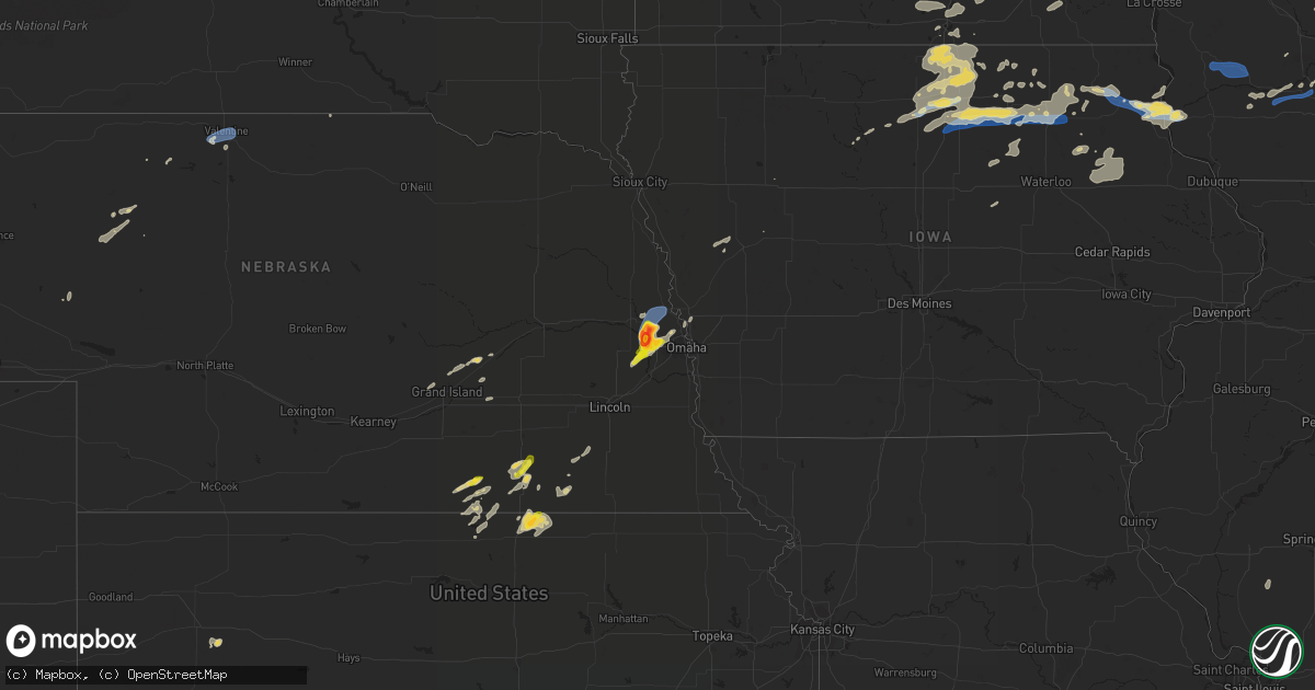
Hail Map on August 27, 2021
Get this storm
August 27 map
$229
one time, instant access
Download today. No call, no setup
Keep the $229
Bought the map and want the full workflow? Apply the entire $229 to a subscription within 7 days. None of it is wasted.
Every map, not just this one
This buys you this map. Subscription and you get every map we run, in the markets you choose from a few cities to whole states to nationwide. Plus real-time alerts the moment a storm fires.
Contact data
Name, contact info, occupancy, even credit band for addresses in the footprint. You go from where it hit to who to call.
Become the source they trust
Unlimited branding weather history reports on demand. You already have the documented answer ready for the property owner, and you are the one who showed up with it.
Property data and RoofTrace estimates
Pull up any address you have got, its value and the exact code rules for that jurisdiction, straight from One Click Code. Then RoofTrace estimates the squares, pitch, and roof value, priced the way you price.
States Impacted by Hail Map on August 27, 2021
Storm reports
Rhode Island
| Date | Description |
|---|---|
| 08/26/20218:58 PM CDT | At 158 PM EDT, a severe thunderstorm was located near Exeter, or 8 miles west of North Kingstown, moving southeast at 10 mph. HAZARD...60 mph wind gusts and penny size hail. SOURCE...Radar indicated. IMPACT...Expect damage to trees and power lines. Locations impacted include... South Kingstown, North Kingstown, Newport, Narragansett, East Greenwich, Hopkinton, Charlestown, Richmond, Exeter, West Greenwich and Jamestown. |
New York
| Date | Description |
|---|---|
| 08/27/20213:50 PM CDT | Multiple downed trees that are blocking several roads on the willowbrook campus of the college of staten island. |
Iowa
| Date | Description |
|---|---|
| 08/27/20216:55 PM CDT | Lots of power outages across the southern part of the county from winds causing downed power lines to lightning strikes. Communities impacted include spillville... Fort |
| 08/27/20216:36 PM CDT | Damage to corn and telephone poles. |
| 08/27/20216:10 PM CDT | Large above ground propane tanks were knocked over by a tornado. |
| 08/27/20216:09 PM CDT | A local report indicates a tornado near 4 SW CHARLES CITY |
| 08/27/20216:00 PM CDT | Damage is extensive south to east-northeast of marble rock. |
| 08/27/20215:56 PM CDT | A local report indicates a tornado near 2 W MARBLE ROCK |
| 08/27/20215:16 PM CDT | Em reports tree damage south of swaledale area. Time estimated via radar. |
| 08/27/20215:15 PM CDT | Trained spotter relayed report to county law enforcement of brief tornado on the ground southeast of clear lake and south of mason city. Unclear of damage at this time. |
| 08/27/20215:12 PM CDT | Trees down. Not all trees were completely healthy... Some were. Time estimated via radar. |
| 08/27/20215:08 PM CDT | Em reports a few tree limbs down around town... Some damage to power lines. Time estimated via radar. |
| 08/27/20215:07 PM CDT | Trained spotter relayed report to em of brief tornado touch down west of burchinal. Time esimated via radar. |
| 08/27/20214:54 PM CDT | Small tree limbs down... 1-3 inches in diameter. Knocked down a powerline as well. From social media picture. |
| 08/27/20214:52 PM CDT | Delayed report: some tree damage reported around the clear lake area. Power outages also reported. Time estimated via radar. |
| 08/27/20215:12 AM CDT | Delayed report of several large trees down early saturday morning. Time estimated by radar. |
| 08/27/20213:15 AM CDT | At 814 PM CDT, a severe thunderstorm was located 7 miles southwest of St. Ansgar, or 11 miles west of Osage, moving northeast at 25 mph. HAZARD...60 mph wind gusts and quarter size hail. SOURCE...Radar indicated. IMPACT...Hail damage to vehicles is expected. Expect wind damage to roofs, siding, and trees. This severe thunderstorm will remain over mainly rural areas of eastern Worth and northeastern Cerro Gordo Counties, including the following locations... Grafton, Bolan, Kensett, Plymouth and Rock Falls. |
| 08/27/20213:15 AM CDT | Report of numerous tree branches and some larger trees down. |
| 08/27/20213:09 AM CDT | At 809 PM CDT, a severe thunderstorm was located 7 miles east of Manly, or 11 miles northeast of Mason City, moving northeast at 35 mph. HAZARD...60 mph wind gusts and quarter size hail. SOURCE...Radar indicated. IMPACT...Hail damage to vehicles is expected. Expect wind damage to roofs, siding, and trees. Locations impacted include... Osage, St. Ansgar, Stacyville, and Mitchell. |
| 08/27/20212:08 AM CDT | At 707 PM CDT, a severe thunderstorm was located near Kennard, or 20 miles northwest of Omaha, moving north at 25 mph. HAZARD...60 mph wind gusts and quarter size hail. SOURCE...Radar indicated. IMPACT...Hail damage to vehicles is expected. Expect wind damage to roofs, siding, and trees. This severe thunderstorm will be near... Blair around 725 PM CDT. |
| 08/27/20211:52 AM CDT | At 651 PM CDT, a severe thunderstorm was located over Calmar, or 9 miles southwest of Decorah, moving east at 40 mph. HAZARD...60 mph wind gusts and quarter size hail. SOURCE...Radar indicated. IMPACT...Hail damage to vehicles is expected. Expect wind damage to roofs, siding, and trees. Locations impacted include... Decorah, Waukon, Postville, Calmar, Ossian, Spillville, Fort Atkinson, Castalia, and Jackson Junction. |
| 08/27/20211:21 AM CDT | At 621 PM CDT, a severe thunderstorm was located over Yutan, or 18 miles west of Omaha, moving northeast at 20 mph. HAZARD...Ping pong ball size hail and 60 mph wind gusts. SOURCE...Radar indicated. IMPACT...People and animals outdoors will be injured. Expect hail damage to roofs, siding, windows, and vehicles. Expect wind damage to roofs, siding, and trees. This severe thunderstorm will be near... Valley and Waterloo around 635 PM CDT.Other locations in the path of this severe thunderstorm includeElkhorn and northwestern Omaha. |
| 08/26/202111:58 PM CDT | At 458 PM CDT, a severe thunderstorm was located 10 miles northeast of Belmond, or 12 miles southeast of Garner, moving northeast at 30 mph. HAZARD...60 mph wind gusts and quarter size hail. SOURCE...Radar indicated. IMPACT...Hail damage to vehicles is expected. Expect wind damage to roofs, siding, and trees. Locations impacted include... Rockwell.This includes Interstate 35 between mile markers 177 and 187. |
| 08/26/202111:23 PM CDT | At 422 PM CDT, a severe thunderstorm was located 7 miles south of Garner, moving northeast at 40 mph. HAZARD...60 mph wind gusts and quarter size hail. SOURCE...Radar indicated. IMPACT...Hail damage to vehicles is expected. Expect wind damage to roofs, siding, and trees. Locations impacted include... Clear Lake and Mason City Municipal Airport.This includes Interstate 35 between mile markers 185 and 197. |
| 08/26/20219:00 PM CDT | At 200 AM CDT, severe thunderstorms were located along a line extending from near Larrabee to near Aurelia to near Holstein, moving east at 45 mph. HAZARD...60 mph wind gusts. SOURCE...Radar indicated. IMPACT...Expect damage to roofs, siding, and trees. Severe thunderstorms will be near... Alta around 215 AM CDT. Storm Lake around 220 AM CDT.Other locations in the path of these severe thunderstorms includeLinn Grove, Truesdale, Sioux Rapids, Lakeside, Newell, Albert Cityand Marathon. |
| 08/26/20218:25 PM CDT | At 125 AM CDT, severe thunderstorms were located along a line extending from 6 miles east of Struble to near Kingsley to 7 miles east of Salix, moving east at 40 mph. HAZARD...70 mph wind gusts and penny size hail. SOURCE...Radar indicated. IMPACT...Expect considerable tree damage. Damage is likely to mobile homes, roofs, and outbuildings. Severe thunderstorms will be near... Kingsley around 130 AM CDT. Remsen around 135 AM CDT. Pierson around 140 AM CDT. Marcus and Correctionville around 145 AM CDT.Other locations in the path of these severe thunderstorms includeAnthon, Washta, Quimby, Cleghorn, Holstein, Cushing, Larrabee, BattleCreek and Galva. |
| 08/26/20218:12 PM CDT | Delayed report. Areal photography shows extensive wind damage to crops about 2 miles north of rock falls iowa. Time estimated via radar. |
| 08/26/20218:09 PM CDT | At 109 AM CDT, severe thunderstorms were located along a line extending from Doon to near Sioux Center to near Struble, moving east at 45 mph. HAZARD...70 mph wind gusts. SOURCE...Radar indicated. IMPACT...Expect considerable tree damage. Damage is likely to mobile homes, roofs, and outbuildings. Severe thunderstorms will be near... Boyden and Hospers around 120 AM CDT. Remsen, George and Matlock around 125 AM CDT.Other locations in the path of these severe thunderstorms includeSheldon, Alton, Archer, Granville, Sibley, Sanborn, Ashton, Melvin,Hartley, Paullina, Primghar and Ocheyedan. |
| 08/26/20218:07 PM CDT | Report of powerlines down. |
| 08/26/20217:42 PM CDT | Power lines down. |
Maryland
| Date | Description |
|---|---|
| 08/27/20216:33 PM CDT | Downed wires near perry cabin lane. Time estimated from radar. |
| 08/27/20216:31 PM CDT | Downed tree limbs and wires near grace street. Time estimated from radar. |
| 08/27/20216:23 PM CDT | Tree feel into a residence on cloverfields dr. No injuries. |
| 08/27/20215:35 PM CDT | A tree blew down in the 100 block of reckford road. |
| 08/27/20215:30 PM CDT | Trees blew down on md-24 rocks road south of saint clair bridge road. |
| 08/27/20215:17 PM CDT | Powerline wires down on the 12000 block of stoney batter road |
| 08/27/20215:15 PM CDT | Trees blew down near forest hill and jarrettsville... Including near the intersection of md-152 fallston road and fox meadow court... And in the 1800 block of parkwood |
| 08/27/20215:11 PM CDT | Tree down on fallston road near fox meadow court. |
| 08/27/20214:50 PM CDT | A tree and wires blew down on md-137 mount carmel road near cedar grove road. A tree blew down on md-138 monkton road near piney woods road. |
| 08/27/20214:25 PM CDT | Trees blew down on westbound us-50/us-301 prior to exit 32/md-908 oceanic drive. |
| 08/27/20214:03 PM CDT | A tree blew down in belvedere park. |
| 08/27/20213:50 PM CDT | Trees and wires blew down in herald harbor. |
| 08/27/20213:45 PM CDT | Trees and wires down in herald harbor. |
| 08/27/20213:40 PM CDT | Trees and wires blew down in millersville... Including along i-97 between exits 12 and 14. |
| 08/27/20213:17 PM CDT | Tree down on us-15 |
| 08/27/20213:14 PM CDT | Trees blew down on us-15 near emmitsburg. |
| 08/27/20212:54 PM CDT | Tree down and powerline wires down on the 1000 block of mimosa lane |
| 08/27/20212:54 PM CDT | Multiple trees down on elm street in takoma park. |
| 08/27/20212:45 PM CDT | Tree down and powerlines down on the 100 block of eastmoor drive |
| 08/27/20212:45 PM CDT | A tree and wires blew down on md-180 jefferson pike near wye creek drive. |
| 08/27/20212:40 PM CDT | *** 3 inj *** numerous trees and wires blew down in silver spring and takoma park. A tree and wires blew down onto a car on md-97 georgia avenue just south of i-495 cap |
| 08/27/20212:35 PM CDT | Tree down on the 2000 block of clark place |
| 08/27/20212:35 PM CDT | Tree and wires down on jefferson pike near wye creek drive. |
| 08/27/20212:33 PM CDT | Several trees blew down near the i-495 capital beltway/md-185 connecticut avenue interchange. |
| 08/27/20212:26 PM CDT | Powerline wires down on the 6000 block of tilden lane |
| 08/27/20212:21 PM CDT | Multiple trees down in the willerburn acres neighborhood. |
| 08/27/20212:21 PM CDT | Trees blew down on the ramp for exit 41 from i-495 capital beltway inner loop to westbound clara barton parkway. |
| 08/27/20212:17 PM CDT | Numerous trees and large branches blew down around montgomery mall... Including on gainsborough road north of democracy boulevard... And on democracy boulevard near the |
| 08/27/20212:16 PM CDT | A local report indicates 62 MPH wind near 1 NW GAITHERSBURG |
| 08/27/20212:11 PM CDT | A local report indicates 62 MPH wind near 2 E NORTH POTOMAC |
| 08/27/20214:35 AM CDT | At 935 PM EDT, severe thunderstorms were located along a line extending from near Woodbridge to 8 miles west of Montclair, moving east at 20 mph. HAZARD...60 mph wind gusts and quarter size hail. SOURCE...Radar indicated. IMPACT...Damaging winds will cause some trees and large branches to fall. This could injure those outdoors, as well as damage homes and vehicles. Roadways may become blocked by downed trees. Localized power outages are possible. Unsecured light objects may become projectiles. Locations impacted include... Stafford, Waldorf, Dale City, La Plata, Quantico, Montclair, Triangle, Dumfries, Saint Charles, Cherry Hill, Independent Hill, Bryans Road, Hughesville, Mason Neck, Potomac Heights, Bryantown, Pomfret, Port Tobacco Village, Garrisonville and Ironsides. |
| 08/27/20212:37 AM CDT | At 736 PM EDT, a severe thunderstorm was located near Overton, or 9 miles west of Centerville, moving east at 20 mph. HAZARD...60 mph wind gusts and penny size hail. SOURCE...Radar indicated. IMPACT...Damage to roofs, siding, trees, and power lines is possible. Locations impacted include... Chestertown, Rock Hall, Church Hill, Newtown, Starkey Corner, Morgnec, Old Town, Crumpton, Kennedyville, Langford and Kingstown. |
| 08/27/20212:10 AM CDT | At 710 PM EDT, severe thunderstorms were located along a line extending from near Magothy River to near Romancoke to Town Creek, moving east at 15 mph. HAZARD...60 mph wind gusts and penny size hail. SOURCE...Radar indicated. IMPACT...Damage to roofs, siding, trees, and power lines is possible. Locations impacted include... Easton, Centerville, Talbot, Centreville, Trappe, St. Michaels, Queen Anne, Grasonville, Starr, Stevensville, Skipton, Copperville, Chester, Matthews, Wye Mills, Hambleton, Cordova, Carville, Tilghman Island and Queenstown. |
| 08/27/20211:28 AM CDT | At 627 PM EDT, severe thunderstorms were located along a line extending from near Rhode River to near Dunkirk to 6 miles southeast of Waldorf, moving east at 25 mph. HAZARD...60 mph wind gusts. SOURCE...Radar indicated. IMPACT...Damaging winds will cause some trees and large branches to fall. This could injure those outdoors, as well as damage homes and vehicles. Roadways may become blocked by downed trees. Localized power outages are possible. Unsecured light objects may become projectiles. Locations impacted include... Chesapeake Ranch Estates, Mayo, Shady Side, Chesapeake Beach, Deale, Prince Frederick, Greenwell State Park, Hallowing Point, Saint Leonard Creek, Breezy Point, Town Creek, Rhode River, Cuckold Creek, Sheridan Point, Calvert Cliffs, Flag Harbor, California, Golden Beach, Dunkirk and Lusby. |
| 08/27/20211:17 AM CDT | At 616 PM EDT, a severe thunderstorm was located near Jarrettsville, or 8 miles northeast of Cockeysville, moving north at 20 mph. HAZARD...60 mph wind gusts and quarter size hail. SOURCE...Radar indicated. IMPACT...Damaging winds will cause some trees and large branches to fall. This could injure those outdoors, as well as damage homes and vehicles. Roadways may become blocked by downed trees. Localized power outages are possible. Unsecured light objects may become projectiles. Locations impacted include... Cockeysville, Bel Air North, Fallston, Kingsville, Pleasant Hills, Jarrettsville, Pylesville, Fork, Cardiff, Benson, Norrisville, Baldwin, Long Green, Hydes, Forest Hill, Chrome Hill, Bynum, Street, Rocks and Jacksonville. |
| 08/27/20211:10 AM CDT | At 610 PM EDT, severe thunderstorms were located along a line extending from near Upper Marlboro to near Saint Charles, moving northeast at 25 mph. HAZARD...60 mph wind gusts. SOURCE...Radar indicated. IMPACT...Damaging winds will cause some trees and large branches to fall. This could injure those outdoors, as well as damage homes and vehicles. Roadways may become blocked by downed trees. Localized power outages are possible. Unsecured light objects may become projectiles. Locations impacted include... Waldorf, La Plata, Saint Charles, Bryans Road, Hughesville, Bryantown, Pomfret, Northwood, Dentsville and White Plains. |
| 08/27/202112:52 AM CDT | At 552 PM EDT, a severe thunderstorm was located near Cockeysville, moving northeast at 10 mph. HAZARD...60 mph wind gusts. SOURCE...Radar indicated. IMPACT...Damaging winds will cause some trees and large branches to fall. This could injure those outdoors, as well as damage homes and vehicles. Roadways may become blocked by downed trees. Localized power outages are possible. Unsecured light objects may become projectiles. Locations impacted include... Jarrettsville, Pylesville, Glencoe, Chrome Hill, Street, Rocks, Hereford, Sparks and Monkton. |
| 08/27/202112:21 AM CDT | At 520 PM EDT, a severe thunderstorm was located over Woodbridge, moving east at 20 mph. HAZARD...60 mph wind gusts. SOURCE...Radar indicated. IMPACT...Damaging winds will cause some trees and large branches to fall. This could injure those outdoors, as well as damage homes and vehicles. Roadways may become blocked by downed trees. Localized power outages are possible. Unsecured light objects may become projectiles. Locations impacted include... Waldorf, Dale City, Clinton, Springfield, Fort Washington, Fort Hunt, Groveton, La Plata, Fort Belvoir, Woodbridge, National Harbor, Andrews Air Force Base, Lake Ridge, Montclair, Camp Springs, Lorton, Franconia, Oxon Hill, Hybla Valley and Newington. |
| 08/27/202112:06 AM CDT | At 505 PM EDT, a severe thunderstorm was located near Manchester, or 10 miles southeast of Parkville, moving northeast at 20 mph. HAZARD...60 mph wind gusts. SOURCE...Radar indicated. IMPACT...Damaging winds will cause some trees and large branches to fall. This could injure those outdoors, as well as damage homes and vehicles. Roadways may become blocked by downed trees. Localized power outages are possible. Unsecured light objects may become projectiles. Locations impacted include... Manchester, Bentley Springs, Millers, Freeland, Lineboro and Maryland Line. |
| 08/26/202111:59 PM CDT | At 459 PM EDT, severe thunderstorms were located along a line extending from Glen Burnie to near Severna Park, moving northeast at 20 mph. HAZARD...60 mph wind gusts. SOURCE...Radar indicated. IMPACT...Damaging winds will cause some trees and large branches to fall. This could injure those outdoors, as well as damage homes and vehicles. Roadways may become blocked by downed trees. Localized power outages are possible. Unsecured light objects may become projectiles. Locations impacted include... Annapolis, Riviera Beach, Naval Academy, Magothy River, Dobbins Island, Severn River, Fort Smallwood State Park, Pinehurst, Gibson Island, Sillery Bay, Bodkin Point, Glen Burnie, Severna Park, Pasadena, Arnold, Lake Shore, Ferndale, Parole, Green Haven and Linthicum. |
| 08/26/202110:25 PM CDT | At 325 PM EDT, a severe thunderstorm was located over Braddock Heights, or near Frederick, moving east at 10 mph. HAZARD...60 mph wind gusts and quarter size hail. SOURCE...Radar indicated. IMPACT...Damaging winds will cause some trees and large branches to fall. This could injure those outdoors, as well as damage homes and vehicles. Roadways may become blocked by downed trees. Localized power outages are possible. Unsecured light objects may become projectiles. Locations impacted include... Frederick, Harry Grove Stadium, Ballenger Creek, Braddock Heights, Clover Hill, Discovery-Spring Garden, Linganore-Bartonsville, Bloomfield, Middletown In Frederick Md, Clifton, Utica and Lewistown. |
| 08/26/20219:36 PM CDT | A tree blew down near the intersection of asher road and cox drive. |
| 08/26/20219:30 PM CDT | A tree blew down near the intersection of md-6 charles street and dubois road. A tree blew down near the intersection of dubois road and trinity church road. |
| 08/26/20219:22 PM CDT | A tree blew down near the intersection of md-231 burnt store road and old leonardtown road. |
| 08/26/20219:10 PM CDT | Trees blew down on md-5 leonardtown road south of md-488 la plata road. |
Indiana
| Date | Description |
|---|---|
| 08/27/20216:20 PM CDT | Several trees down in rush county and rushville. Most of rushville is without power. Time is estimated from radar. |
| 08/27/20216:20 PM CDT | North of us 52 and east 5th street in rushville a tree was blown down into a house. Most of rushville is without power. Time is estimated from radar. |
| 08/27/20216:20 PM CDT | Several trees down in rush county and rushville. Time is estimated from radar. |
| 08/27/20214:33 PM CDT | Tree down. Time estimated by radar. |
| 08/27/20214:02 PM CDT | Structural damage to outbuilding. Roof of barn blown off. Time estimated using radar data. |
| 08/27/202112:08 AM CDT | At 507 PM EDT, a severe thunderstorm was located 8 miles northeast of Owenton, moving north at 20 mph. HAZARD...60 mph wind gusts. SOURCE...Radar indicated. IMPACT...Expect damage to trees and power lines. Locations impacted include... Williamstown, Walton, Crittenden, Dry Ridge, Glencoe, Sparta, Patriot, Stewartsville, Ryle, Big Bone Lick, Interstate 71 at US Route 127, Steele Bottom, Bracht, Beaverlick, Sherman, Egypt Bottom, Elliston, Munk, Eagle Hill and Napoleon.This includes the following Interstates... I-71 in Kentucky between mile markers 59 and 77. I-75 in Kentucky between mile markers 159 and 174. |
| 08/27/202112:01 AM CDT | At 501 PM EDT, a severe thunderstorm was located 7 miles south of Versailles, moving northwest at 10 mph. HAZARD...60 mph wind gusts. SOURCE...Radar indicated. IMPACT...Expect damage to trees and power lines. Locations impacted include... Versailles, Farmers Retreat, Friendship, Versailles Lake, Cross Plains, Rexville, Benham, Olean and New Marion. |
Montana
| Date | Description |
|---|---|
| 08/27/20215:40 PM CDT | A local report indicates 1.00 inch wind near BAYLOR |
| 08/26/202111:35 PM CDT | At 435 PM MDT, a severe thunderstorm was located 14 miles south of Opheim, moving east at 20 mph. HAZARD...60 mph wind gusts and quarter size hail. SOURCE...Radar indicated. IMPACT...Hail damage to vehicles is expected. Expect wind damage to roofs, siding, and trees. Locations impacted include... Baylor. |
| 08/26/202111:27 PM CDT | At 427 PM MDT, a severe thunderstorm was located 11 miles south of Gustave, or 32 miles north of Belle Fourche, moving east at 40 mph. HAZARD...Ping pong ball size hail and 60 mph wind gusts. SOURCE...Radar indicated. IMPACT...People and animals outdoors will be injured. Expect hail damage to roofs, siding, windows, and vehicles. Expect wind damage to roofs, siding, and trees. Locations impacted include... Crow Buttes, Haystack Buttes, Hoover and Sheep Buttes. |
Arizona
| Date | Description |
|---|---|
| 08/27/20216:36 PM CDT | Asos station ksad safford regional airport. |
| 08/26/20218:38 PM CDT | At 137 PM MST, a severe thunderstorm was located 9 miles west of Arivaca, or 25 miles west of Tubac, moving southwest at 5 mph. HAZARD...60 mph wind gusts and quarter size hail. SOURCE...Radar indicated. IMPACT...Hail damage to vehicles is expected. Expect wind damage to roofs, siding, and trees. Locations impacted include... Sasabe. |
Michigan
| Date | Description |
|---|---|
| 08/27/20216:53 PM CDT | Tree down on wires near u.s. Forest service ranger station in baldwin. Pea-sized hail also observed. Relayed via wfo apx. |
| 08/27/20216:50 PM CDT | Numerous trees and limbs down in baldwin area...via lake county dispatch. Time estimated from radar and consumers energy outage map. |
| 08/27/202112:30 PM CDT | Numerous trees and wires down. Time estimated by radar. |
| 08/27/20213:12 AM CDT | At 812 PM EDT, a severe thunderstorm was located 9 miles southwest of Reed City, or 10 miles southeast of Baldwin, moving southeast at 25 mph. HAZARD...60 mph wind gusts and quarter size hail. SOURCE...Radar indicated. IMPACT...Hail damage to vehicles is expected. Expect wind damage to roofs, siding, and trees. Locations impacted include... Big Rapids... Paris... Hawkins... |
| 08/27/20213:00 AM CDT | Social media pictures of multiple trees/large limbs down. |
| 08/27/20212:49 AM CDT | At 749 PM EDT, a severe thunderstorm was located over Baldwin, moving east at 20 mph. HAZARD...60 mph wind gusts and quarter size hail. SOURCE...Radar indicated. IMPACT...Hail damage to vehicles is expected. Expect wind damage to roofs, siding, and trees. Locations impacted include... Chase... Idlewild... |
| 08/27/20212:36 AM CDT | At 735 PM EDT, a severe thunderstorm was located near Baldwin, moving east at 20 mph. HAZARD...60 mph wind gusts and quarter size hail. SOURCE...Radar indicated. IMPACT...Hail damage to vehicles is expected. Expect wind damage to roofs, siding, and trees. Locations impacted include... Baldwin... Luther... Chase... Nirvana... Bristol... Wolf Lake... Idlewild... |
South Dakota
| Date | Description |
|---|---|
| 08/27/20216:42 PM CDT | A local report indicates 1.00 inch wind near 1 WNW HOOVER |
| 08/27/20216:42 PM CDT | A local report indicates 70 MPH wind near 1 WNW HOOVER |
| 08/27/20216:20 PM CDT | Time estimated |
| 08/27/20217:34 AM CDT | At 1233 AM CDT, severe thunderstorms were located along a line extending from near Newton Hills State Park to near Alcester to 6 miles west of Akron, moving east at 40 mph. HAZARD...70 mph wind gusts. SOURCE...Radar indicated. IMPACT...Expect considerable tree damage. Damage is likely to mobile homes, roofs, and outbuildings. Severe thunderstorms will be near... Hawarden around 1240 AM CDT. Fairview around 1245 AM CDT. Hudson around 1250 AM CDT.Other locations in the path of these severe thunderstorms includeIreton, Rock Valley, Craig, Sioux Center, Maurice, Struble, Le Mars,Orange City, Hull, Alton and Boyden. |
| 08/27/20217:17 AM CDT | At 1216 AM CDT, a pair of severe thunderstorms were located near Fairview, or 10 miles southeast of Canton, moving northeast at 50 mph. HAZARD...60 mph wind gusts and quarter size hail. SOURCE...Radar indicated. IMPACT...Hail damage to vehicles is expected. Expect wind damage to roofs, siding, and trees. This severe thunderstorm will be near... Rock Valley around 1220 AM CDT. Alvord around 1225 AM CDT. Doon around 1230 AM CDT. Rock Rapids around 1235 AM CDT.Other locations in the path of these severe thunderstorms include George. |
| 08/27/20217:08 AM CDT | At 1208 AM CDT, severe thunderstorms were located along a line extending from near Davis to near Centerville to 6 miles southeast of Wakonda, moving east at 35 mph. HAZARD...70 mph wind gusts. SOURCE...Radar indicated. IMPACT...Expect considerable tree damage. Damage is likely to mobile homes, roofs, and outbuildings. Severe thunderstorms will be near... Beresford around 1220 AM CDT. Union Grove State Park around 1225 AM CDT.Other locations in the path of these severe thunderstorms includeAlcester. |
| 08/27/20216:50 AM CDT | Time estimated based on radar. |
| 08/27/20216:03 AM CDT | Golf ball sized hail is ongoing. |
| 08/27/20215:44 AM CDT | Picture of hail of 2 inches in diameter. Mentioned that some were a little larger. There was also a large tree limb down and windshields broken just west of town. |
| 08/27/20214:34 AM CDT | Hailing for the last 10 minutes. |
| 08/27/20214:30 AM CDT | A local report indicates 1.50 inch wind near 6 W WARNER |
| 08/27/20214:13 AM CDT | A local report indicates 58 MPH wind near 4 SSE WITTEN |
| 08/27/20214:08 AM CDT | Measured tennis ball sized hail. Several windows broken on house. Hail is covering the ground. |
| 08/27/20214:00 AM CDT | 50 mph or stronger winds. |
| 08/27/20213:48 AM CDT | 10 windows destroyed. |
| 08/27/20213:25 AM CDT | A local report indicates 1.00 inch wind near 4 N CRAVENS CORNER |
| 08/27/20213:20 AM CDT | A local report indicates 1.00 inch wind near 3 S ROSCOE |
| 08/27/20212:32 AM CDT | Numerous hailstones up to tennis ball sized and decreased to golf ball sized before ending. Ground was white with hail. |
| 08/27/20211:56 AM CDT | A local report indicates 1.00 inch wind near 3 NNE SELBY |
| 08/27/20211:35 AM CDT | A local report indicates 1.25 inch wind near GLENHAM |
| 08/27/202112:39 AM CDT | At 539 PM MDT, a severe thunderstorm was located 3 miles southeast of Hoover, or 38 miles southeast of Buffalo, moving east at 45 mph. HAZARD...Tennis ball size hail and 60 mph wind gusts. SOURCE...Radar indicated. IMPACT...People and animals outdoors will be injured. Expect hail damage to roofs, siding, windows, and vehicles. Expect wind damage to roofs, siding, and trees. This severe thunderstorm will be near... Zeona around 555 PM MDT.Other locations in the path of this severe thunderstorm include MudButte, Maurine, Durkee Lake, Arrow Head Buttes and Faith. |
| 08/26/20218:44 PM CDT | At 144 AM CDT, severe thunderstorms were located along a line extending from near Agar to 7 miles east of Canning, moving northeast at 35 mph. HAZARD...60 mph wind gusts and quarter size hail. SOURCE...Radar indicated. IMPACT...Hail damage to vehicles is expected. Expect wind damage to roofs, siding, and trees. Severe thunderstorms will be near... Agar around 150 AM CDT. Cottonwood Lake Near Agar around 200 AM CDT.Other locations in the path of these severe thunderstorms includeHarrold, Holabird, Stone Lake and Highmore. |
| 08/26/20218:06 PM CDT | At 106 AM CDT/1206 AM MDT/, a severe thunderstorm was located near Okobojo Point Rec Area, or 14 miles northwest of Fort Pierre, moving northeast at 40 mph. HAZARD...60 mph wind gusts and quarter size hail. SOURCE...Radar indicated. IMPACT...Hail damage to vehicles is expected. Expect wind damage to roofs, siding, and trees. This severe thunderstorm will be near... Cow Creek Rec Area, Okobojo Point Rec Area and Spring Creek Rec Area around 110 AM CDT. Grey Goose around 115 AM CDT.Other locations in the path of this severe thunderstorm include SullyLake, Onida and Agar. |
| 08/26/20217:30 PM CDT | A local report indicates 60 MPH wind near 10 ESE ZEONA |
Ohio
| Date | Description |
|---|---|
| 08/27/20216:58 PM CDT | Several trees were blown down. |
| 08/27/20215:23 PM CDT | Local broadcast meteorologist reported trees down and power lines down. |
| 08/27/20215:23 PM CDT | Trees down and power poles down |
| 08/27/20215:00 PM CDT | Power poles down. Time estimated by radar along outflow boundary. |
| 08/27/20214:57 PM CDT | Power poles down. Time estimated by radar- likely along outflow boundary. |
| 08/27/20214:55 PM CDT | Power poles down. Time estimated by radar along outflow boundary. |
| 08/27/20214:53 PM CDT | Trees down. Time estimated by radar. |
| 08/27/20212:54 AM CDT | At 754 PM EDT, a severe thunderstorm was located over Sidney, and is nearly stationary. HAZARD...60 mph wind gusts and penny size hail. SOURCE...Radar indicated. IMPACT...Expect damage to trees and power lines. Locations impacted include... Sidney, Anna, Botkins, Hardin, Port Jefferson, Maplewood, Montra, Newbern, Mccartyville and Swanders.This includes I-75 in Ohio between mile markers 88 and 103. |
| 08/27/20212:52 AM CDT | At 752 PM EDT, a severe thunderstorm was located near Troy, moving north at 25 mph. HAZARD...60 mph wind gusts. SOURCE...Radar indicated. IMPACT...Expect damage to trees and power lines. Locations impacted include... Troy, Piqua, Tipp City, Brown, Fletcher, Casstown, Farrington, Haven View, Grayson and Ginghamsburg.This includes I-75 in Ohio between mile markers 66 and 85. |
| 08/27/20211:26 AM CDT | At 626 PM EDT, a severe thunderstorm was located near Morrow, moving east at 25 mph. HAZARD...60 mph wind gusts. SOURCE...Radar indicated. IMPACT...Expect damage to trees and power lines. Locations impacted include... Mason, Lebanon, Sharonville, Monroe, Blue Ash, Loveland, Reading, Montgomery, Madeira, Milford, Deer Park, Blanchester, West Chester, Terrace Park, Batavia, Morrow, Camp Dennison, Highpoint, Remington and Concorde Hills.This includes the following Interstates... I-71 in Ohio between mile markers 12 and 41. I-75 in Ohio between mile markers 21 and 29. |
| 08/27/20211:18 AM CDT | At 618 PM EDT, a severe thunderstorm was located near Georgetown, moving north at 10 mph. HAZARD...60 mph wind gusts and penny size hail. SOURCE...Radar indicated. IMPACT...Expect damage to trees and power lines. Locations impacted include... Georgetown, Mount Orab, Hamersville, State Route 32 at US Route 68, Feesburg, Lake Waynoka, New Hope and Locust Ridge. |
Florida
| Date | Description |
|---|---|
| 08/27/20216:08 PM CDT | Report of a tree on a home near otter creek. |
| 08/27/20216:00 PM CDT | Multiple trees and power lines reported down across leon county. |
| 08/27/20215:48 PM CDT | Duke energy reported a power outage due to fallen trees on equipment. |
| 08/27/20215:42 PM CDT | Half of a large live oak tree fell across mossy creek ln. |
| 08/27/20215:00 PM CDT | Report of trees down with power outages near foley rd and hwy19. |
| 08/27/20212:51 AM CDT | At 750 PM EDT/650 PM CDT/, a severe thunderstorm was located near Bainbridge, moving northwest at 40 mph. HAZARD...60 mph wind gusts. SOURCE...Radar indicated. IMPACT...Expect damage to roofs, siding, and trees. Locations impacted include... Colquitt, Bainbridge, Donalsonville, West Bainbridge, Iron City, Brinson, Jakin, Hanover, Ausmac, Babcock, Reynoldsville, Little Hope, Recovery, Decatur Co A/P, Boykin, Riverturn, Sharphagen, Hornsville, Donaldsonville A/P and Bellview. |
| 08/27/20211:41 AM CDT | At 641 PM EDT, severe thunderstorms were located along a line extending from near Monticello to 16 miles east of Tallahassee to 9 miles east of Woodville to 11 miles east of St. Marks to 18 miles west of Perry, moving northwest at 30 mph. HAZARD...60 mph wind gusts. SOURCE...Radar indicated. IMPACT...Expect damage to roofs, siding, and trees. Locations impacted include... St. Marks, Woodville, Tallahassee, Crawfordville, Florida State University, Florida A And M, Tallahassee Comm College, Doak Campbell Stadium, Wakulla, Lake Bradford, Cody, Shadeville, Leon Sinks, Gaither Community Center, Wakulla Springs, Tallahassee Memorial Hosp, Eight Mile Pond, Drifton, Tallahassee Mall and Bethel. |
| 08/27/20211:16 AM CDT | At 616 PM EDT, a severe thunderstorm was located 16 miles northwest of Perry, moving west at 30 mph. HAZARD...60 mph wind gusts. SOURCE...Radar indicated. IMPACT...Expect damage to roofs, siding, and trees. Locations impacted include... Cody, Goose Pasture, Hells Half Acre, Iddo, Ebb, Lamont, Capps, Lois, Eridu, Nash, Cabbage Grove, Thomas City, Drifton, Econfina, Lake Bird, Fanlew, Waukeenah, Wacissa, Lloyd and Wacissa Springs. |
| 08/27/202112:23 AM CDT | A southeast wind gust of 56 kts... Or 64 mph... Was recorded by the key west international airport asos at 123 am edt. This site also recorded a 1-minute sustained wind |
North Dakota
| Date | Description |
|---|---|
| 08/27/20216:40 PM CDT | Report relayed via emergency management. |
| 08/27/20216:36 PM CDT | A lot of small hail with the largest stone 1 inch. Hail damaged a pickup truck. Report relayed via social media. |
| 08/27/20212:06 AM CDT | At 706 PM CDT, a severe thunderstorm was located 13 miles northwest of Mandaree, or 20 miles east of Watford City, moving east at 40 mph. HAZARD...Ping pong ball size hail and 60 mph wind gusts. SOURCE...Radar indicated. IMPACT...People and animals outdoors will be injured. Expect hail damage to roofs, siding, windows, and vehicles. Expect wind damage to roofs, siding, and trees. This severe thunderstorm will be near... 4 Bears Lodge around 725 PM CDT.Other locations in the path of this severe thunderstorm include NewTown, Van Hook Park and Parshall. |
| 08/27/20211:43 AM CDT | At 642 PM CDT, a severe thunderstorm was located over Alamo, or 21 miles south of Crosby, moving northeast at 35 mph. HAZARD...60 mph wind gusts and quarter size hail. SOURCE...Radar indicated. IMPACT...Hail damage to vehicles is expected. Expect wind damage to roofs, siding, and trees. This severe thunderstorm will remain over mainly rural areas of north central Williams and southeastern Divide Counties, including the following locations... Corinth. |
| 08/27/20211:23 AM CDT | At 623 PM CDT, a severe thunderstorm was located near Arnegard, or 5 miles northwest of Watford City, moving northeast at 35 mph. HAZARD...Ping pong ball size hail and 60 mph wind gusts. SOURCE...Radar indicated. IMPACT...People and animals outdoors will be injured. Expect hail damage to roofs, siding, windows, and vehicles. Expect wind damage to roofs, siding, and trees. This severe thunderstorm will be near... Watford City around 630 PM CDT. |
| 08/27/202112:58 AM CDT | At 558 PM CDT, a severe thunderstorm was located 9 miles east of Bonetrail, or 19 miles north of Williston, moving northeast at 20 mph. HAZARD...Ping pong ball size hail and 60 mph wind gusts. SOURCE...Radar indicated. IMPACT...People and animals outdoors will be injured. Expect hail damage to roofs, siding, windows, and vehicles. Expect wind damage to roofs, siding, and trees. Locations impacted include... Alamo. |
| 08/26/20217:38 PM CDT | Radar estimated time. |
Kansas
| Date | Description |
|---|---|
| 08/27/20215:15 PM CDT | Delayed report. Microburst winds blew the roof off a large farm equipment shelter. Time is estimated based on radar and homeowner. Winds estimated to be around 75 mph. |
| 08/27/202112:15 AM CDT | At 515 PM CDT, a severe thunderstorm was located near Narka, moving northeast at 20 mph. This warning replaces the severe thunderstorm warning that was set to expire at 515 PM. HAZARD...60 mph wind gusts and penny size hail. SOURCE...Radar indicated. IMPACT...Expect damage to roofs, siding, and trees. Locations impacted include... Narka and Mahaska. |
| 08/26/202111:27 PM CDT | At 427 PM CDT, a severe thunderstorm was located near Munden, moving northeast at 20 mph. HAZARD...60 mph wind gusts. SOURCE...Radar indicated. IMPACT...Expect damage to roofs, siding, and trees. Locations impacted include... Munden, Narka and Mahaska. |
Delaware
| Date | Description |
|---|---|
| 08/27/20214:04 AM CDT | At 904 PM EDT, a severe thunderstorm was located over Sandtown, or 13 miles southwest of Dover, moving east at 15 mph. HAZARD...60 mph wind gusts. SOURCE...Radar indicated. IMPACT...Damage to roofs, siding, trees, and power lines is possible. Locations impacted include... Dover, Harrington, Camden, Bowers, Woodside, Viola, Rising Sun-Lebanon, Rising Sun, Hazlettville, Dover Base Housing, Big Stone Beach, Dover Speedway, Sandtown, Wyoming, Felton, Frederica, Magnolia, Little Creek, Marydel and Rodney Village. |
| 08/26/20218:04 PM CDT | Downed tree on wires near hayfield road. Time estimated from radar. |
Massachusetts
| Date | Description |
|---|---|
| 08/27/20214:23 PM CDT | Large limb down on house on king street. |
| 08/27/20214:20 PM CDT | Tree down on amostown road at fausey drive. Relayed via amateur radio. |
| 08/27/20214:15 PM CDT | Tree down on wires on granby road. |
| 08/27/20214:10 PM CDT | Tree down on woodmont street. Relayed by amateur radio |
| 08/26/202111:59 PM CDT | At 457 PM EDT, a severe thunderstorm was located over West Springfield, moving southeast at 20 mph. HAZARD...60 mph wind gusts and penny size hail. SOURCE...Radar indicated. IMPACT...Expect damage to trees and power lines. Locations impacted include... Springfield, Chicopee, Enfield, Westfield, Holyoke, Vernon, Agawam, West Springfield, Ludlow, South Hadley, Longmeadow, Suffield, East Longmeadow, Ellington, Tolland, Wilbraham, Coventry, Stafford, Somers and East Windsor. |
Nebraska
| Date | Description |
|---|---|
| 08/27/20216:45 PM CDT | A local report indicates 1.00 inch wind near 4 N NELSON |
| 08/27/20216:43 PM CDT | Hail the size of ping pong balls was observed at nws omaha. |
| 08/27/20216:40 PM CDT | Peak wind gust of 60 mph was measured at nws omaha. |
| 08/27/20216:37 PM CDT | Caller reported 2 hailstone. |
| 08/27/20216:36 PM CDT | Report passed along by broadcast media. Time estimated based on radar data. |
| 08/27/20216:28 PM CDT | Corrects previous hail report from 2 ene elkhorn. Located at 175th and maple. |
| 08/27/20216:22 PM CDT | Corrects previous hail report from yutan. Report from twitter. |
| 08/27/20216:07 PM CDT | Nws employee sent in picture of hail the size of quarters. |
| 08/27/20215:50 PM CDT | A local report indicates 1.25 inch wind near BRUNING |
| 08/27/20214:31 PM CDT | Metal shed/garage blown down report via twitter. |
| 08/27/20213:45 AM CDT | A local report indicates 62 MPH wind near 1 ENE VALENTINE |
| 08/27/20213:39 AM CDT | A local report indicates 63 MPH wind near VALENTINE |
| 08/27/20212:26 AM CDT | Heat burst observed by kvtn asos. Thundershowers in the vicinity. |
| 08/27/20211:54 AM CDT | At 654 PM CDT, a severe thunderstorm was located near Oak, or 30 miles southeast of Hastings, moving northeast at 30 mph. HAZARD...Quarter size hail. SOURCE...Trained weather spotters. IMPACT...Damage to vehicles is expected. This severe thunderstorm will be near... Edgar around 700 PM CDT. Davenport around 710 PM CDT.Other locations in the path of this severe thunderstorm include Ong,Shickley and Carleton. |
| 08/27/20211:43 AM CDT | At 640 PM CDT, a severe thunderstorm was located over Valley, or 18 miles west of Omaha, moving north at 15 mph. HAZARD...Two inch hail and 60 mph wind gusts. SOURCE...Trained weather spotters. IMPACT...People and animals outdoors will be injured. Expect hail damage to roofs, siding, windows, and vehicles. Expect wind damage to roofs, siding, and trees. Locations impacted include... Arlington. |
| 08/27/20211:41 AM CDT | At 639 PM CDT, a severe thunderstorm was located over Valley, or 18 miles west of Omaha, moving north at 15 mph. HAZARD...Two inch hail and 60 mph wind gusts. SOURCE...Trained weather spotters. Two inch hail was reported in Valley, and a 60 mph wind gust was reported at the Weather Service Office. IMPACT...People and animals outdoors will be injured. Expect hail damage to roofs, siding, windows, and vehicles. Expect wind damage to roofs, siding, and trees. Locations impacted include... Arlington. |
| 08/27/20211:04 AM CDT | At 604 PM CDT, a severe thunderstorm was located over Yutan, or 17 miles west of Omaha, moving northeast at 25 mph. HAZARD...Ping pong ball size hail and 60 mph wind gusts. SOURCE...Radar indicated. IMPACT...People and animals outdoors will be injured. Expect hail damage to roofs, siding, windows, and vehicles. Expect wind damage to roofs, siding, and trees. This severe thunderstorm will be near... Valley around 615 PM CDT. Waterloo around 620 PM CDT.Other locations in the path of this severe thunderstorm includeElkhorn. |
| 08/27/202112:57 AM CDT | At 557 PM CDT, a severe thunderstorm was located near Bruning, or 35 miles south of York, moving northeast at 20 mph. HAZARD...Half dollar size hail near Bruning at 550 PM. SOURCE...Trained weather spotters. IMPACT...Damage to vehicles is expected. This severe thunderstorm will be near... Ohiowa around 610 PM CDT.Other locations in the path of this severe thunderstorm includeMilligan. |
| 08/26/20217:11 PM CDT | Report from mping: 3-inch tree limbs broken; power poles broken. |
| 08/26/20217:07 PM CDT | 60 mph measured from mesonet site up342. |
Alabama
| Date | Description |
|---|---|
| 08/27/20216:01 PM CDT | Trees and powerlines down. |
Virginia
| Date | Description |
|---|---|
| 08/27/20214:33 PM CDT | Trees blew down near the intersection of anita drive and cardiff street. |
| 08/27/20214:26 PM CDT | Tree down on route 4301 near cardiff street. |
| 08/27/20213:58 PM CDT | Tree and power pole down on gilmore drive. |
| 08/27/20213:58 PM CDT | Tree and power pole down on gilmore drive. |
| 08/27/20213:55 PM CDT | Trees blew down onto wires bringing down a power pole on gilmore drive. |
| 08/27/20213:45 PM CDT | They responded to calls for several trees down on and around black rock road. |
| 08/27/20213:20 PM CDT | Corrects previous tstm wnd dmg report from 4 ssw stewartsville. Trees down near the intersection of whispering heights drive and coopers cove road. |
| 08/27/20213:20 PM CDT | Trees down near the intersection of edwardsville road and hardy road. |
| 08/27/20213:15 PM CDT | Tree down on a power line at the intersection of virginia ridge road and hardy road. |
| 08/27/20213:13 PM CDT | Over 20 large trees were blown down by thunderstorm winds. Trees blocked windhurst drive and hardy road. |
| 08/27/20212:26 PM CDT | Tree down on the northbound ramp of george washington parkway to i-495. |
| 08/27/20212:21 PM CDT | Trees blew down on the northbound ramp of george washington memorial parkway to i-495 capital beltway... Including one onto a car. |
| 08/27/20212:17 PM CDT | A tree blew down blocking the southside of days farm drive near black-eyed susan lane. |
| 08/27/20212:12 PM CDT | Tree down on route 7380 near black-eyed susan lane. |
| 08/27/20215:08 AM CDT | At 1008 PM EDT, severe thunderstorms were located along a line extending from near Dunkirk to near Quantico, moving southeast at 20 mph. HAZARD...60 mph wind gusts and quarter size hail. SOURCE...Radar indicated. IMPACT...Damaging winds will cause some trees and large branches to fall. This could injure those outdoors, as well as damage homes and vehicles. Roadways may become blocked by downed trees. Localized power outages are possible. Unsecured light objects may become projectiles. Locations impacted include... Waldorf, La Plata, Chesapeake Beach, Dahlgren, Prince Frederick, Nanjemoy Creek, Popes Creek, Hallowing Point, Breezy Point, Sheridan Point, Port Tobacco River, Flag Harbor, Calvert Cliffs, Golden Beach, Dunkirk, Saint Charles, Saint Leonard, Wicomico, Huntingtown and Hughesville. |
| 08/26/202111:46 PM CDT | At 446 PM EDT, a severe thunderstorm was located over Newington, or over Springfield, moving east at 20 mph. HAZARD...60 mph wind gusts. SOURCE...Radar indicated. IMPACT...Damaging winds will cause some trees and large branches to fall. This could injure those outdoors, as well as damage homes and vehicles. Roadways may become blocked by downed trees. Localized power outages are possible. Unsecured light objects may become projectiles. Locations impacted include... Annandale, Springfield, Fort Hunt, Groveton, Fort Belvoir, Woodbridge, Burke, Lincolnia, Lorton, Franconia, Newington, I395 and I495 Interchange, West Springfield, Mount Vernon, North Springfield, Hayfield, Ravensworth, Mason Neck and Occoquan. |
| 08/26/202111:39 PM CDT | At 439 PM EDT, a severe thunderstorm was located over Burnt Chimney, or near Rocky Mount, moving southeast at 5 mph. HAZARD...60 mph wind gusts and quarter size hail. SOURCE...Radar indicated. IMPACT...Hail damage to vehicles is expected. Expect wind damage to roofs, siding, and trees. Locations impacted include... Rocky Mount... Burnt Chimney... Western Smith Mountain Lake... Union Hall... Southern Smith Mountain Lake... Wirtz... and North Shore. |
| 08/26/202111:14 PM CDT | At 414 PM EDT, a severe thunderstorm was located over Pamplin City, or 8 miles northeast of Red House, and is nearly stationary. HAZARD...60 mph wind gusts and quarter size hail. SOURCE...Radar indicated. IMPACT...Minor damage to vehicles is possible. Expect wind damage to trees and powerlines. Locations impacted include... Darlington Heights, Elam and Allens Mill. # # |
| 08/26/202111:13 PM CDT | At 412 PM EDT, a severe thunderstorm was located over Stewartsville, moving east at 5 mph. HAZARD...60 mph wind gusts and quarter size hail. SOURCE...Radar indicated. IMPACT...Hail damage to vehicles is expected. Expect wind damage to roofs, siding, and trees. Locations impacted include... Moneta... Stewartsville... Chamblissburg... Northwest Smith Mountain Lake... Goodview... Westlake Corner... and North Shore. |
| 08/26/20219:35 PM CDT | At 234 PM EDT, a severe thunderstorm was located near Lowes Island, moving east at 15 mph. HAZARD...60 mph wind gusts and quarter size hail. SOURCE...Radar indicated. IMPACT...Damaging winds will cause some trees and large branches to fall. This could injure those outdoors, as well as damage homes and vehicles. Roadways may become blocked by downed trees. Localized power outages are possible. Unsecured light objects may become projectiles. Locations impacted include... Germantown, Rockville, Gaithersburg, Olney, Damascus, Lowes Island, Poolesville, Aspen Hill, Potomac, North Bethesda, Montgomery Village, North Potomac, Redland, Great Falls, Boyds, Rossmoor, Wheaton-Glenmont, Wheaton, Cloverly and Clarksburg. |
Kentucky
| Date | Description |
|---|---|
| 08/27/20214:23 PM CDT | Tree down across roadway. |
| 08/27/20213:43 PM CDT | Tree knocked down |
| 08/27/202112:15 AM CDT | At 515 PM EDT, a severe thunderstorm was located near Dry Ridge, moving north at 35 mph. HAZARD...60 mph wind gusts. SOURCE...Radar indicated. IMPACT...Expect damage to trees and power lines. Locations impacted include... Williamstown, Walton, Claryville, Crittenden, Dry Ridge, Butler, Stewartsville, Visalia, Atwood, Grants Lick, Northcutt, Bracht, Gardnersville, White Villa, Campbell County Lake, Fiskburg, Sherman, Goforth, Greenwood and Aspen Grove.This includes I-75 in Kentucky between mile markers 153 and 169. |
| 08/26/202111:40 PM CDT | At 439 PM EDT, a severe thunderstorm was located over Elsie, or near Salyersville, moving northeast at 10 mph. HAZARD...60 mph wind gusts and penny size hail. SOURCE...Radar indicated. IMPACT...Expect damage to roofs, siding, and trees. This severe thunderstorm will be near... Licksburg around 450 PM EDT.Other locations in the path of this severe thunderstorm includeTella. |
| 08/26/202111:39 PM CDT | At 439 PM EDT, a severe thunderstorm was located 9 miles south of Williamstown, moving north at 20 mph. HAZARD...60 mph wind gusts. SOURCE...Radar indicated. IMPACT...Expect damage to trees and power lines. Locations impacted include... Williamstown, Falmouth, Dry Ridge, Morgan, Corinth, Goforth, Stewartsville, Cherry Grove, Northcutt, Williamstown Lake, Knoxville, Marcus, Keefer, Camp Northward, Gene Snyder Airport, Lawrenceville and Cordova.This includes I-75 in Kentucky between mile markers 143 and 160. |
Minnesota
| Date | Description |
|---|---|
| 08/27/20212:10 AM CDT | At 709 PM CDT, a severe thunderstorm was located over Clear Lake, or 10 miles west of Mason City, moving northeast at 30 mph. HAZARD...60 mph wind gusts and quarter size hail. SOURCE...Radar indicated. IMPACT...Hail damage to vehicles is expected. Expect wind damage to roofs, siding, and trees. This severe thunderstorm will be near... Mason City Municipal Airport around 715 PM CDT.Other locations in the path of this severe thunderstorm include MasonCity and Manly.This includes Interstate 35 between mile markers 193 and 208. |
| 08/26/20218:52 PM CDT | At 152 AM CDT, severe thunderstorms were located along a line extending from near Ocheyedan to near Sanborn to near Paullina, moving east at 45 mph. HAZARD...60 mph wind gusts. SOURCE...Radar indicated. IMPACT...Expect damage to roofs, siding, and trees. Severe thunderstorms will be near... Hartley and Ocheyedan around 200 AM CDT. Round Lake and Harris around 205 AM CDT. Everly around 210 AM CDT.Other locations in the path of these severe thunderstorms includeLake Park, Peterson, Spencer In Clay County, Okoboji, Royal,Wahpeton, Fostoria, Linn Grove, Spirit Lake, Sioux Rapids, Orleans,Greenville, Terril, Webb and Superior. |
Pennsylvania
| Date | Description |
|---|---|
| 08/27/20216:09 PM CDT | A few reports of downed trees and wires in centre twp. Time estimated from radar. |
| 08/27/20216:00 PM CDT | Multiple reports of trees down between penn twp and centerport. Time estimated from radar. |
| 08/27/20215:56 PM CDT | Downed trees and wires near plum road. Time estimated from radar. |
| 08/27/20215:36 PM CDT | Downed trees and wires near station road. Time estimated from radar. |
| 08/27/20215:31 PM CDT | Downed tree limbs and wires west of reider road. Time estimated from radar. |
| 08/27/20215:31 PM CDT | Downed trees and wires near steely road and church road. Time estimated from radar. |
| 08/27/20214:58 PM CDT | Strong thunderstorm winds knocked down tree onto roadway. |
| 08/27/20214:40 PM CDT | Tree on wires. |
| 08/27/20214:40 PM CDT | Trees on wires. |
| 08/27/20214:36 PM CDT | Tree on wires. |
| 08/27/20214:15 PM CDT | Part of a roof blown off of a barn. |
| 08/27/20214:15 PM CDT | Several trees down in the area. Several outbuildings at a farm collapsed. |
| 08/27/20211:42 PM CDT | Downed tree on rainbow road near west lincoln highway. Time estimated from radar. |
| 08/27/20211:34 PM CDT | Downed tree limbs and wires near blackberry lane. Time estimated from radar. |
| 08/27/20211:30 PM CDT | Multiple trees down at route 30 bypass and moore road. Time estimated. |
| 08/27/20211:30 PM CDT | Trees down along route 84 between 30 bypass and 30 business just north of coatesville. Time estimated from radar. |
| 08/27/20211:26 PM CDT | Downed tree in wires on molasses valley road. Time estimated from radar. |
| 08/27/20211:20 PM CDT | Tree and pole down in the 900 block of horseshoe pike. Time estimated from radar. |
| 08/27/20211:18 PM CDT | Several trees down in the area of pratts dam road. Time estimated from radar. |
| 08/27/20211:13 PM CDT | Multiple trees down on hurley road. Time estimated from radar. |
| 08/27/20211:10 PM CDT | Several large branches down blocking traffic. Time estimated from radar. |
| 08/27/20211:05 PM CDT | Several trees reported down around caln township. Time estimated from radar. |
| 08/27/20211:04 PM CDT | Multiple trees down on osborne road. Time estimated from radar. |
| 08/27/202112:59 PM CDT | Downed wires near state route 115. Time estimated from radar. |
| 08/27/202112:36 PM CDT | Downed wires near maple drive. Time estimated from radar. |
| 08/27/202111:33 AM CDT | Downed tree limbs and wires near country place drive. Time estimated from radar and outage reports. |
| 08/27/202112:38 AM CDT | At 538 PM EDT, severe thunderstorms were located along a line extending from near Le Roy to near Grover, moving southeast at 15 mph. HAZARD...60 mph wind gusts and quarter size hail. SOURCE...Radar indicated. IMPACT...Hail damage to vehicles is expected. Expect wind damage to roofs, siding, and trees. Locations impacted include... West Franklin, West Burlington, New Albany, Overton, Franklindale, Le Roy, South Branch, West Le Roy and Evergreen. |
| 08/27/202112:16 AM CDT | At 516 PM EDT, a severe thunderstorm was located over Strasburg, moving north at 10 mph. HAZARD...60 mph wind gusts and penny size hail. SOURCE...Radar indicated. IMPACT...Expect damage to roofs, siding, and trees. Locations impacted include... Lancaster, Willow Street, New Holland, Leola, Paradise, Strasburg, Quarryville, Gap, Leacock, Bareville, Smithville, Lampeter, Intercourse, Georgetown, Farmersville, Gordonville, Bird-In-Hand, Smoketown, Refton and White Horse. |
| 08/26/202111:14 PM CDT | At 414 PM EDT, a severe thunderstorm was located near Taneytown, or 9 miles west of Westminster, moving northeast at 15 mph. HAZARD...60 mph wind gusts and quarter size hail. SOURCE...Radar indicated. IMPACT...Damaging winds will cause some trees and large branches to fall. This could injure those outdoors, as well as damage homes and vehicles. Roadways may become blocked by downed trees. Localized power outages are possible. Unsecured light objects may become projectiles. Locations impacted include... Westminster, Emmitsburg, Taneytown, Hampstead, Manchester, New Windsor, Union Bridge, Harney, Linwood, Uniontown, Wagners Mill, Greenmount, Keysville and Keymar. |
| 08/26/202110:07 PM CDT | At 307 PM EDT, a severe thunderstorm was located over Harmony, or near Easton, and is nearly stationary. HAZARD...60 mph wind gusts. SOURCE...Radar indicated. IMPACT...Damage to roofs, siding, trees, and power lines is possible. Locations impacted include... Easton, Forks, Wilson, Harmony, Alpha, West Easton, Tatamy, Glendon, Roxburg, Old Orchard, Brass Castle, Phillipsburg, Stockertown and Palmer Heights.This includes the following highways... Interstate 78 in Pennsylvania between mile markers 74 and 76. Interstate 78 in New Jersey between mile markers 0 and 7. |
| 08/26/20219:42 PM CDT | At 241 PM EDT, a severe thunderstorm was located over Parkesburg, or 13 miles southeast of New Holland, moving west at 5 mph. HAZARD...60 mph wind gusts. SOURCE...Radar indicated. IMPACT...Damage to roofs, siding, trees, and power lines is possible. Locations impacted include... Coatesville, Parkesburg, Cochranville, Atglen, South Coatesville and Modena. |
| 08/26/20219:38 PM CDT | At 238 PM EDT, a severe thunderstorm was located over Hope, or 15 miles southwest of Newton, moving east at 5 mph. HAZARD...60 mph wind gusts. SOURCE...Radar indicated. IMPACT...Damage to roofs, siding, trees, and power lines is possible. Locations impacted include... Hackettstown, Oxford, Hope, Great Meadows-Vienna, Beatyestown, Allamuchy-Panther Valley and Beattyestown.This includes Interstate 80 in New Jersey between mile markers 6 and18. |
| 08/26/20218:52 PM CDT | At 152 PM EDT, a severe thunderstorm was located over Downingtown, or near West Chester, and is nearly stationary. HAZARD...60 mph wind gusts. SOURCE...Radar indicated. IMPACT...Damage to roofs, siding, trees, and power lines is possible. Locations impacted include... West Chester, Coatesville, Downingtown, Lionville, Marshallton, Lionville-Marchwood, West Goshen, South Coatesville, Modena, Exton and Thorndale.This includes Pennsylvania Turnpike between mile markers 308 and 313. |
New Jersey
| Date | Description |
|---|---|
| 08/27/20214:10 PM CDT | Corrects previous tstm wnd dmg report from monroe twp. Corrects previous tstm wnd dmg report from monroe twp. Strong winds snapped an old tree trunk. Time estimated fro |
| 08/27/20214:05 PM CDT | Corrects previous tstm wnd dmg report from monroe twp. Strong winds snapped an old tree trunk. Time estimated from radar. |
| 08/27/20213:55 PM CDT | Strong winds snapped an old tree trunk. Time estimated from radar. |
| 08/27/20212:37 PM CDT | Downed wires near monroe avenue. Time estimated from radar. |
| 08/27/20212:27 PM CDT | Downed pole and wires on u.s. Highway 9 near 8th street. Time estimated from radar. |
| 08/27/20212:21 PM CDT | Downed wires near germania station road. Time estimated from radar. |
| 08/27/20212:10 PM CDT | Trees down on powerlines. Time estimated from radar. |
| 08/27/20212:02 PM CDT | Spotter reported several downed tree limbs and being blown over while attempting to close barn doors. Time estimated from radar. |
| 08/27/20212:00 PM CDT | Downed wires near pinewald keswick road. Time estimated from radar. |
| 08/27/20211:59 PM CDT | An mping report of downed tree limbs. |
| 08/27/20211:58 PM CDT | Downed trees and wires near hudson lane. Time estimated from radar. |
| 08/27/20211:55 PM CDT | Downed trees and wires near mountain lake road. Time estimated from radar. |
| 08/27/20211:50 PM CDT | Small area of limbs down just west of great meadows along us 46. Time estimated from radar. |
| 08/27/20211:39 PM CDT | Downed trees and wires near mount hermon road. Time estimated from radar. |
| 08/27/202112:02 AM CDT | At 501 PM EDT, a severe thunderstorm was located over Dorothy, or 8 miles southeast of Vineland, moving east at 5 mph. HAZARD...60 mph wind gusts and penny size hail. SOURCE...Radar indicated. IMPACT...Damage to roofs, siding, trees, and power lines is possible. Locations impacted include... Vineland, Millville, Cumberland, Egg Harbor City, Estell Manor, Dorothy, Mays Landing and English Creek.This includes Atlantic City Expressway between mile markers 13 and17. |
| 08/26/202111:06 PM CDT | At 406 PM EDT, a severe thunderstorm was located near Monroe Township, or 14 miles north of Vineland, and is nearly stationary. HAZARD...60 mph wind gusts and penny size hail. SOURCE...Radar indicated. IMPACT...Damage to roofs, siding, trees, and power lines is possible. Locations impacted include... Glassboro, Clayton, Chesilhurst, Victory Lakes, Sicklerville, Williamstown and Monroe Township.This includes Atlantic City Expressway between mile markers 31 and40. |
| 08/26/202110:30 PM CDT | At 330 PM EDT, a severe thunderstorm was located over Wharton State Forest, or 24 miles north of Atlantic City, and is nearly stationary. HAZARD...60 mph wind gusts. SOURCE...Radar indicated. IMPACT...Damage to roofs, siding, trees, and power lines is possible. Locations impacted include... Barnegat, Brookville, Warren Grove, Bass River State Forest, Wharton State Forest, Chatsworth, Old Halfway, Penn State Forest, Wading River, Beach Haven West, Ocean Acres and Manahawkin.This includes Garden State Parkway between mile markers 52 and 70. |
| 08/26/20219:59 PM CDT | At 258 PM EDT, a severe thunderstorm was located near Beachwood, or 7 miles southwest of Toms River, and is nearly stationary. HAZARD...60 mph wind gusts and penny size hail. SOURCE...Radar indicated. IMPACT...Damage to roofs, siding, trees, and power lines is possible. Locations impacted include... Toms River, Beachwood, Seaside Heights, Holiday City-Berkeley, Bamber Lake, Holiday City South, Pleasant Plains, Pine Ridge At Crestwood, Dover Beaches South, Leisure Village West-Pine Lake Park, Dover Beaches North, South Toms River, Island Heights, Silver Ridge, Crestwood Village, Gilford Park, Holiday City, Holiday Heights and Waretown.This includes Garden State Parkway between mile markers 71 and 86. |
| 08/26/20219:37 PM CDT | At 235 PM EDT, a severe thunderstorm was located over Beach Haven West, or 21 miles south of Toms River, moving northeast at 5 mph. HAZARD...60 mph wind gusts. SOURCE...Radar indicated. IMPACT...Damage to roofs, siding, trees, and power lines is possible. Locations impacted include... Barnegat, Beachwood, Surf City, Brookville, Warren Grove, Beach Haven West, South Toms River, Manahawkin, Holiday Heights, Ocean Acres and Waretown.This includes Garden State Parkway between mile markers 60 and 80. |
| 08/26/20219:32 PM CDT | At 232 PM EDT, a severe thunderstorm was located over Rossland, or 14 miles northwest of Easton, and is nearly stationary. HAZARD...60 mph wind gusts. SOURCE...Radar indicated. IMPACT...Damage to roofs, siding, trees, and power lines is possible. Locations impacted include... Easton, East Stroudsburg, Nazareth, Bangor, Pen Argyl, Wind Gap, Belfast, Tatamy, East Bangor, Stormville, Brodheadsville, Kunkletown, Gilbert, Delaware Water Gap, Rossland, Kresgeville, Saylorsburg, Penn Forest Reservoir, Stroudsburg and Roseto.This includes the following highways... Interstate 80 in Pennsylvania between mile markers 308 and 314. Interstate 80 in New Jersey near mile marker 0. |
New Mexico
| Date | Description |
|---|---|
| 08/27/20211:28 AM CDT | At 627 PM MDT, a severe thunderstorm was located near Organ, moving southwest at 5 mph. HAZARD...Quarter size hail. SOURCE...Radar indicated. IMPACT...Damage to vehicles is expected. Locations impacted include... Organ, Talavera, East Mesa, Northeast Las Cruces, Aguirre Springs and Portions of Organ Mountains Desert Peaks National Monument.This includes Highway 70 in New Mexico between mile markers 154 and163. |
| 08/26/20218:42 PM CDT | At 142 PM MDT, a severe thunderstorm was located 8 miles north of Mimbres, moving southwest at 20 mph. HAZARD...Quarter size hail. SOURCE...Radar indicated. IMPACT...Damage to vehicles is expected. Locations impacted include... Mimbres, Camp Thunderbird, Georgetown, Upper Mimbres Valley and Bear Canyon Lake. |
Georgia
| Date | Description |
|---|---|
| 08/27/202112:45 AM CDT | At 545 PM CDT, a severe thunderstorm was located over Ladonia, or over Phenix City, moving northwest at 25 mph. HAZARD...60 mph wind gusts and penny size hail. SOURCE...Radar indicated. IMPACT...Expect damage to roofs, siding, and trees. Locations impacted include... Phenix City, Smiths, Smiths Station, Ladonia, Bleecker, Griffen Mill, Monterey Heights, Uchee Creek, Fort Mitchell, Ladonia Sports Complex, Phenix Drag Strip and Parkmanville. |
Wisconsin
| Date | Description |
|---|---|
| 08/27/20216:39 PM CDT | 51 knots measured at the wisconsin rapids airport. Law enforcement reported a couple of trees down on the north side of town. |
| 08/27/20213:46 PM CDT | Delayed report: multiple pines knocked down and damage to tree branches on properties along plank road in greenbush. Report relayed via broadcast media. Time estimated |
| 08/27/202110:40 AM CDT | Combination of lightning strikes and wind gusts to 40 to 50 mph with resultant tree damage resulted in several power outages in the fox lake area. |
| 08/27/20219:35 AM CDT | Tree snapped off at base. |
| 08/27/20216:53 AM CDT | At 1152 PM CDT, a severe thunderstorm was located 10 miles south of La Farge, or 13 miles northwest of Richland Center, moving east at 30 mph. HAZARD...60 mph wind gusts. SOURCE...Radar indicated. IMPACT...Expect damage to roofs, siding, and trees. Locations impacted include... Richland Center, Lone Rock, Ithaca, and Boaz. |
| 08/27/20216:31 AM CDT | At 1131 PM CDT, a severe thunderstorm was located near Viroqua, moving east at 30 mph. HAZARD...60 mph wind gusts and nickel size hail. SOURCE...Radar indicated. IMPACT...Expect damage to roofs, siding, and trees. Locations impacted include... Viroqua, La Farge, Germantown, Rockbridge, Viola, Sylvan, Liberty, and Readstown. |
| 08/27/20214:27 AM CDT | At 927 AM CDT, severe thunderstorms were located along a line extending from near Prairie Du Sac to near Black Earth, moving east at 35 mph. HAZARD...60 mph wind gusts and penny size hail. SOURCE...Radar indicated. IMPACT...Expect damage to roofs, siding, and trees. Locations impacted include... Madison, Sun Prairie, Middleton, Waunakee, Windsor, Lake Wisconsin, Deforest, Cross Plains, Lodi, Poynette, Maple Bluff, Dane, Arlington, Merrimac, Harmony Grove, Morrisonville, Pine Bluff, Token Creek, Interstate 90/94 Interchange and Okee. |
| 08/27/20213:57 AM CDT | At 856 AM CDT, severe thunderstorms were located along a line extending from 6 miles northwest of Spring Green to near Dodgeville, moving northeast at 35 mph. HAZARD...60 mph wind gusts and penny size hail. SOURCE...Radar indicated. IMPACT...Expect damage to roofs, siding, and trees. Locations impacted include... Baraboo, Dodgeville, Prairie Du Sac, Sauk City, Mazomanie, Spring Green, Black Earth, Barneveld, Blue Mounds, Arena, Plain, Bluffview, Ridgeway, Clyde, Governor Dodge St Park, Blue Mound St Park and Devils Lake St Park. |
| 08/27/20213:48 AM CDT | At 848 PM CDT, a severe thunderstorm was located near Bloomington, or 11 miles southeast of Prairie Du Chien, moving east at 20 mph. HAZARD...60 mph wind gusts and quarter size hail. SOURCE...Radar indicated. IMPACT...Hail damage to vehicles is expected. Expect wind damage to roofs, siding, and trees. Locations impacted include... Lancaster, Fennimore, Bloomington, Mount Ida, Ellenboro, Mount Hope, Patch Grove, Millville, Stitzer, Porters Bridge, Lancaster Municipal Airport, Klondyke Secluded Acres and Brodtville. |
| 08/27/20213:03 AM CDT | At 802 PM CDT, a severe thunderstorm was located near McGregor, or near Prairie Du Chien, moving east at 30 mph. HAZARD...60 mph wind gusts and nickel size hail. SOURCE...Trained weather spotters. IMPACT...Expect damage to roofs, siding, and trees. Locations impacted include... Prairie Du Chien, McGregor, Bloomington, Marquette, Bridgeport, Beetown, Mount Ida, Bagley, and Mount Hope. |
| 08/27/20212:55 AM CDT | At 755 PM CDT, severe thunderstorms were located along a line extending from 6 miles northwest of Pulaski to near Black Creek, moving east at 40 mph. HAZARD...60 mph wind gusts. SOURCE...Radar indicated. IMPACT...Expect damage to roofs, siding, and trees. Severe thunderstorms will be near... Pulaski around 800 PM CDT.Other locations in the path of these severe thunderstorms includeBellevue Town, Bay Shore Park and Denmark. |
| 08/27/20212:29 AM CDT | At 729 PM CDT, a severe thunderstorm was located near Postville, or 10 miles southwest of Waukon, moving southeast at 40 mph. HAZARD...60 mph wind gusts and penny size hail. SOURCE...Radar indicated. IMPACT...Expect damage to roofs, siding, and trees. Locations impacted include... Postville, Monona, McGregor, Marquette, Farmersburg, Hardin, Luana, Castalia, and Waterville. |
| 08/26/202111:44 PM CDT | At 444 PM CDT, a severe thunderstorm was located near Theresa, or 7 miles southeast of Mayville, moving east at 25 mph. HAZARD...60 mph wind gusts and quarter size hail. SOURCE...Radar indicated. IMPACT...Hail damage to vehicles is expected. Expect wind damage to roofs, siding, and trees. Locations impacted include... West Bend, Jackson, Slinger, Kewaskum, Theresa, Newburg, Addison, Woodland, Wayne, Nenno, Fillmore, Boltonville, Allenton, Keowns, Nabob, Saint Lawrence and Kohlsville. |
| 08/26/202111:40 PM CDT | Several reports of trees and powerlines down along highway 56 around liberty. |
| 08/26/202111:07 PM CDT | At 407 PM CDT, a severe thunderstorm was located near Plymouth, moving east at 15 mph. HAZARD...60 mph wind gusts. SOURCE...Radar indicated. IMPACT...Expect damage to roofs, siding, and trees. Locations impacted include... Sheboygan, Plymouth, Sheboygan Falls, Howards Grove, Kohler, Haven and Johnsonville. |
| 08/26/202110:01 PM CDT | 1 downed powerline. |
| 08/26/20219:50 PM CDT | Report of a downed tree. |
District of Columbia
| Date | Description |
|---|---|
| 08/26/202110:36 PM CDT | At 335 PM EDT, a severe thunderstorm was located over Chevy Chase, or over Bethesda, moving east at 15 mph. HAZARD...70 mph wind gusts. SOURCE...Radar indicated. IMPACT...Damaging winds will cause some trees and large branches to fall. This could injure those outdoors, as well as damage homes and vehicles. Roadways may become blocked by downed trees. Localized power outages are possible. Unsecured light objects may become projectiles. Locations impacted include... Arlington, Bethesda, Bowie, College Park, Greenbelt, Langley Park, Beltsville, Forestville, Largo, Coral Hills, Bladensburg, Upper Marlboro, Fedex Field, Fort Totten, University of Maryland, Howard University, Gallaudet University, RFK Stadium, Aspen Hill and North Bethesda. |
| 08/26/202110:05 PM CDT | At 304 PM EDT, severe thunderstorms were located along a line extending from Montgomery Village to near Potomac to Reston, moving northeast at 20 mph. HAZARD...60 mph wind gusts. SOURCE...Radar indicated. IMPACT...Damaging winds will cause some trees and large branches to fall. This could injure those outdoors, as well as damage homes and vehicles. Roadways may become blocked by downed trees. Localized power outages are possible. Unsecured light objects may become projectiles. Locations impacted include... Arlington, Rockville, Bethesda, Gaithersburg, Reston, Olney, Herndon, Langley Park, Vienna, Falls Church, Pimmit Hills, Mclean, American Legion Bridge, Aspen Hill, Potomac, North Bethesda, Oakton, Montgomery Village, North Potomac and Fairland. |
Cities Impacted by Hail Map on August 27, 2021
- Webster, SD
- Bristol, SD
- Branch, MI
- Baldwin, MI
- Chase, MI
- Paris, MI
- Bitely, MI
- Reed City, MI
- Idlewild, MI
- Postville, IA
- Rio, WI
- Poynette, WI
- Columbus, WI
- Randolph, WI
- Arlington, WI
- Doylestown, WI
- Fox Lake, WI
- Fall River, WI
- Deforest, WI
- Beaver Dam, WI
- Sadieville, KY
- Corinth, KY
- Socorro, NM
- Yutan, NE
- Ashland, NE
- Mansfield, SD
- Aberdeen, SD
- Datil, NM
- Omaha, NE
- Almond, WI
- Wild Rose, WI
- Superior, NE
- Mankato, KS
- Webber, KS
- Hardy, NE
- Watford City, ND
- Arnegard, ND
- Keene, ND
- New Town, ND
- Mandaree, ND
- Eagle Butte, SD
- Trail City, SD
- Prairie Du Chien, WI
- Bagley, WI
- Hanlontown, IA
- Northwood, IA
- Lake Mills, IA
- Kensett, IA
- Joice, IA
- Marvin, SD
- Summit, SD
- South Shore, SD
- Marble Rock, IA
- Greene, IA
- Rockwell, IA
- Rockford, IA
- Dougherty, IA
- Charles City, IA
- Manistee, MI
- Hoven, SD
- Ipswich, SD
- Central City, NE
- Big Rapids, MI
- Valley, NE
- Arlington, NE
- Faith, SD
- Mason City, IA
- Plymouth, IA
- Manly, IA
- Benson, AZ
- Nelson, NE
- Lawrence, NE
- Oak, NE
- Belvidere, NE
- Narka, KS
- Mahaska, KS
- Belleville, KS
- Munden, KS
- Bruning, NE
- Strang, NE
- Wisconsin Rapids, WI
- Gettysburg, SD
- Agar, SD
- Milbank, SD
- Big Stone City, SD
- Prairie City, SD
- Reva, SD
- Wakpala, SD
- McLaughlin, SD
- Shell Rock, IA
- Clarksville, IA
- Warner, SD
- Roscoe, SD
- Java, SD
- Selby, SD
- Dupree, SD
- Bowdle, SD
- Ortonville, MN
- Waupaca, WI
- Amherst, WI
- Ortley, SD
- Lomira, WI
- Theresa, WI
- Campbellsport, WI
- Mazomanie, WI
- Carleton, NE
- Eau Claire, WI
- Valentine, NE
- Oshkosh, WI
- Winneconne, WI
- Barnard, SD
- Frederick, SD
- Westport, SD
- Leola, SD
- Kennard, NE
- Fremont, NE
- Waterloo, NE
- Bennington, NE
- Hayfield, MN
- Waltham, MN
- Blooming Prairie, MN
- New Hampton, IA
- Casa Blanca, NM
- Cubero, NM
- Parkersburg, IA
- Aplington, IA
- Glenham, SD
- Mobridge, SD
- Ventura, IA
- Garner, IA
- Rock Springs, WI
- Wykoff, MN
- Chatfield, MN
- Larslan, MT
- Calmar, IA
- Ossian, IA
- Decorah, IA
- Mitchell, IN
- Lawler, IA
- Waucoma, IA
- Stratford, SD
- Elkhorn, NE
- Black Creek, WI
- Seymour, WI
- Goodell, IA
- Farmersburg, IA
- Marquette, IA
- McGregor, IA
- Shickley, NE
- Waubay, SD
- Riceville, IA
- Mound City, SD
- Trempealeau, WI
- Dover, MN
- Rollingstone, MN
- Winona, MN
- Lewiston, MN
- Minnesota City, MN
- Utica, MN
- Saint Charles, MN
- Ettrick, WI
- Blair, WI
- Arcadia, WI
- Eyota, MN
- Altura, MN
- Dodge, WI
- Fountain City, WI
- Galesville, WI
- Chilton, WI
- Corona, NM
- Pulaski, WI
- Merriman, NE
- Salyersville, KY
- Phenix City, AL
- Fort Benning, GA
- Aurora, NE
- Hampton, NE
- Timber Lake, SD
- Stephen, MN
- Andover, SD
- Groton, SD
- Conde, SD
- Bath, SD
- Onaka, SD
- Tolstoy, SD
- Rosendale, WI
- Monona, IA
- Eastman, WI
- Harpers Ferry, IA
- Orchard, IA
- Floyd, IA
- Gilead, NE
- Alexandria, NE
- Livermore, IA
- Humboldt, IA
- Wellston, MI
- Osage, IA
- Little Cedar, IA
- Archer, NE
- Alamo, ND
- Luther, MI
- Irons, MI
- Republic, KS
- Byron, NE
- Grinnell, KS
- Custer, MI
- Newport, KY
- Elma, IA
- Hubbell, NE
- Haddam, KS
- Cuba, KS
- Browder, KY
- Drakesboro, KY
- Belton, KY
- Alta Vista, IA
- Milladore, WI
- Auburndale, WI
- Mosinee, WI
- Stratford, WI
- Clarks, NE
- Walkerville, MI
- Masonville, IA
- Edgewood, NM
- Tijeras, NM
- Alexandria, KY
- Morning View, KY
- Independence, KY
- Latonia, KY
- Horicon, WI
- Jonesville, IN
- Columbus, IN
- Marquette, NE
- Hyannis, NE
- Sauk City, WI
- Swanton, NE
- De Witt, NE
- Central City, KY
- Weyauwega, WI
- Fremont, WI
- Pine River, WI
- Hollandale, MN
- Clarks Grove, MN
- Albert Lea, MN
- Ellendale, MN
- Westminster, MD
- Epping, ND
- Canton, PA
- Juneau, WI
- Zumbro Falls, MN
- Fairbury, NE
- Florence, AZ
- Isabel, SD
- Neillsville, WI
- Lewisburg, KY
- Milmay, NJ
- Zahl, ND
- Oelwein, IA
- Edwardsville, IL
- Ohiowa, NE
- Oxford, WI
- Green Bay, WI
- Granton, WI
- Chili, WI
- Bloomington, WI
- Mount Hope, WI
- Luana, IA
- Birdseye, IN
- Fredericksburg, IA
- Thornton, IA
- Nashua, IA
- Ionia, IA
- Swaledale, IA
- Clear Lake, IA
- Saint Ansgar, IA
- Butte Des Morts, WI
- Omro, WI
- Neenah, WI
- Berlin, WI
- Larsen, WI
- Henderson, KY
- Dow City, IA
- Grafton, IA
- Grand Island, NE
- Cairo, NE
- Hartland, MN
- New Richland, MN
- Freeborn, MN
- Wells, MN
- Alden, MN
- West Bend, WI
- Hartford, WI
- Allenton, WI
- Iron Ridge, WI
- Mayville, WI
- Maynard, IA
- Westgate, IA
- Edgewater, MD
- Annapolis, MD
- Louisville, IL
- Akaska, SD
- Ferney, SD
- Pollock, SD
- Williston, ND
- Chapman, NE
- Elkhart Lake, WI
- Kiel, WI
- Paris, KY
- Lawrenceburg, KY
- Evart, MI
- Magdalena, NM
- Shiocton, WI
- Bonduel, WI
- Meservey, IA
- Glenville, MN
- Sheffield, IA
- Alexander, IA
- Fertile, IA
- Forest City, IA
- Kanawha, IA
- Klemme, IA
- Nora Springs, IA
- Fort Atkinson, IA
- Britt, IA
- Rock Falls, IA
- Belmond, IA
- Hayward, MN
- Cambria, WI
- Brandenburg, KY
- Waldorf, MD
- Eden, WI
- Woodman, WI
- Garnavillo, IA
- Rutland, IA
- Hawkeye, IA
- Blairstown, NJ
- Edinburgh, IN
- Bison, SD
- Glen Carbon, IL
- Bethel, OH
- Georgetown, OH
- Meadow, SD
- Alma Center, WI
- Fairchild, WI
- Wilber, NE
- McIntosh, SD
- Castalia, IA
- Cross Plains, IN
- Versailles, IN
- Saint Libory, NE
- Spring Green, WI
- Bear Creek, WI
- Clifton, AZ
- San Carlos, AZ
- Mount Orab, OH
- Hamersville, OH
- Potomac, MD
- Great Falls, VA
- Rockville, MD
- Fort Calhoun, NE
- Dawson, GA
- Courtland, KS
- Owensboro, KY
- Greenville, KY
- Ithaca, NE
- Clintonville, WI
- Hebron, NE
- Deshler, NE
- Woodbridge, VA
- Dumfries, VA
- Tucson, AZ
- Vail, AZ
- Felton, DE
- Greensboro, MD
- Harrington, DE
- Whitman, NE
- Rochester, MN
- Burnett, WI
- Plymouth, WI
- Glenbeulah, WI
- Union Bridge, MD
- Lamont, IA
- Dundee, IA
- Aurora, IA
- Independence, IA
- Hazleton, IA
- Arlington, IA
- Winthrop, IA
- Stanley, IA
- Strawberry Point, IA
- Grundy Center, IA
- Salvisa, KY
- Fallston, MD
- Sparks Glencoe, MD
- Phoenix, MD
- Baldwin, MD
- Monkton, MD
- Lebanon, KY
- Marshfield, WI
- Highland, WI
- Dodgeville, WI
- Arena, WI
- West Union, IA
- Saint Lucas, IA
- Edgar, NE
- New Providence, PA
- Willow Street, PA
- Strasburg, PA
- Greenfield, IL
- Palmyra, IL
- Renwick, IA
- Harrodsburg, KY
- Seymour, IN
- Bedford, IN
- Boonville, IN
- Butler, KY
- Vinton, VA
- Hardy, VA
- Missouri Valley, IA
- Honey Creek, IA
- Glencross, SD
- Phillipsburg, NJ
- Plover, WI
- Sells, AZ
- Jansen, NE
- Ute, IA
- Denison, IA
- Charter Oak, IA
- Chrisney, IN
- Santa Claus, IN
- Winchester, KY
- Merrillan, WI
- Sumner, IA
- Leroy, MI
- Tustin, MI
- Washington, NE
- Karlstad, MN
- Lodi, WI
- Dane, WI
- Avoca, WI
- Fairbank, IA
- Gilboa, NY
- Stamford, NY
- Grand Gorge, NY
- Hartford City, IN
- Latimer, IA
- Patch Grove, WI
- Clermont, IA
- Cross Plains, WI
- Barneveld, WI
- Blue Mounds, WI
- Black Earth, WI
- Ridgeway, WI
- Richland Center, WI
- Blue River, WI
- Muscoda, WI
- Soldiers Grove, WI
- Lone Rock, WI
- Mellette, SD
- Brentford, SD
- Florence, SD
- Newell, SD
- Belle Fourche, SD
- Mud Butte, SD
- Twin Brooks, SD
- Corona, SD
- Columbia, SD
- Hecla, SD
- Silver Spring, MD
- Garrett Park, MD
- Kensington, MD
- Bethesda, MD
- Chevy Chase, MD
- Blair, NE
- Richland, MT