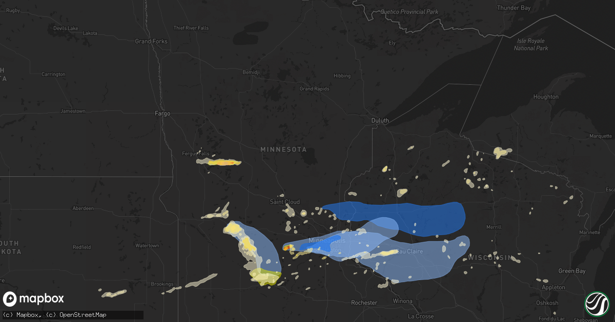
Hail Map in Minnesota on August 26, 2024
Get this storm
August 26 map
$229
one time, instant access
Download today. No call, no setup
Keep the $229
Bought the map and want the full workflow? Apply the entire $229 to a subscription within 7 days. None of it is wasted.
Every map, not just this one
This buys you this map. Subscription and you get every map we run, in the markets you choose from a few cities to whole states to nationwide. Plus real-time alerts the moment a storm fires.
Contact data
Name, contact info, occupancy, even credit band for addresses in the footprint. You go from where it hit to who to call.
Become the source they trust
Unlimited branding weather history reports on demand. You already have the documented answer ready for the property owner, and you are the one who showed up with it.
Property data and RoofTrace estimates
Pull up any address you have got, its value and the exact code rules for that jurisdiction, straight from One Click Code. Then RoofTrace estimates the squares, pitch, and roof value, priced the way you price.
Storm reports in Minnesota
Minnesota
| Date | Description |
|---|---|
| 08/26/20246:55 PM CDT | Large tree branches down. |
| 08/26/20246:52 PM CDT | Report of power outages and a large tree down. Time estimated from radar. |
| 08/26/20246:45 PM CDT | Mesonet station mn022 t.h.7 - new germany - mp 161. |
| 08/26/20246:40 PM CDT | Very large oak tree down. |
| 08/26/20246:35 PM CDT | Trees and power lines down. Time estimated from radar. |
| 08/26/20246:32 PM CDT | Time estimated based on radar. |
| 08/26/20246:30 PM CDT | Picture via facebook. |
| 08/26/20246:30 PM CDT | A local report indicates 1.75 inch wind near Lester Prairie |
| 08/26/20246:28 PM CDT | Numerous large trees snapped or uprooted in a 0.5 mile radius of lynden township hall at the the intersection of county road 44 and county road 143. Time estimated via |
| 08/26/20246:28 PM CDT | Delayed report... Time estimated from radar. Several trees down along i-94 between mile marker 177 and 174. |
| 08/26/20246:18 PM CDT | Mesonet station mn002 t.h.7 - silver lake - mp 155. |
| 08/26/20246:00 PM CDT | Tree down across road. Time estimated. |
| 08/26/20245:55 PM CDT | Two trees down across roads. Time estimated. |
| 08/26/20244:40 PM CDT | Reported at willmar... Willmar municipal airport-john l rice field. |
| 08/26/20242:39 PM CDT | Relayed from social media. |
| 08/26/20242:15 PM CDT | Report relayed via media. |
| 08/26/20242:00 PM CDT | Minor siding and car damage. Time estimated from radar. |
| 08/26/20245:50 AM CDT | Multiple medium-sized live trees snapped... Some uprooted. Diameter approximately 5-7 inches. Many branches down. Time estimated. |
| 08/26/20245:47 AM CDT | Tree down and several large branches down. |
| 08/26/20245:42 AM CDT | Asos station kstp st. Paul dwtn ap. |
| 08/26/20245:39 AM CDT | A branch with a three foot diameter was blown down at harriet island. |
| 08/26/20245:38 AM CDT | Asos station kstp st. Paul dwtn ap. |
| 08/26/20245:33 AM CDT | Trees downed - 12 inches in diameter. |
| 08/26/20245:32 AM CDT | Large uprooted tree in minnesota state fair. Photo sent via twitter. |
| 08/26/20245:32 AM CDT | Large uprooted tree in minnesota state fair. Photo sent via twitter. |
| 08/26/20245:32 AM CDT | Delayed report... Time estimated from radar. Numerous large trees down and blocking roads in como park area. |
| 08/26/20245:32 AM CDT | Trees fell on two houses in the neighborhood... And one house had major damage. Two roads in the neighborhood were blocked by fallen trees. |
| 08/26/20245:28 AM CDT | Asos station kmsp minneapolis-st. Paul ap. |
| 08/26/20245:27 AM CDT | Measured by non-nws meteorologist. |
| 08/26/20245:26 AM CDT | Numerous trees down... Including on a house and truck. |
| 08/26/20245:26 AM CDT | Large uprooted oak tree. Photo sent via twitter. |
| 08/26/20245:24 AM CDT | Large tree snapped at the base. Photo sent via twitter. |
| 08/26/20245:24 AM CDT | Large tree blown over at the root ball and several large 3+ tree branches down. Photos sent via twitter. |
| 08/26/20245:15 AM CDT | A local report indicates 59 MPH wind near Deephaven |
| 08/26/20245:14 AM CDT | Asos station kfcm eden prairie ap. |
| 08/26/20245:14 AM CDT | Large tree branches down in homeowners yard. |
| 08/26/20245:00 AM CDT | Multiple trees over 12 inches in diameter were uprooted with the morning round of storms. Many branches of varying sizes... Construction signs... And outdoor items stre |
| 08/25/20248:27 PM CDT | 6 inch oak branch down due to wind on the east side of lotus lake. |
| 08/25/20248:00 PM CDT | Large branch down... Approximately 10-11 inches in diameter at whiskey road and s. Brookview lane. |
| 08/25/20247:45 PM CDT | Multiple trees down & widespread power outages in town. Time estimated from radar. |
| 08/25/20247:40 PM CDT | Multiple tree |
| 08/25/20247:40 PM CDT | Multiple trees down & widespread power outages in town. Time estimated from radar. |
| 08/25/20247:37 PM CDT | Delayed report of multiple downed tree branches with diameter up to 8 inches. Time estimated from radar. |
| 08/25/20247:35 PM CDT | Mesonet station mn089 i-35e - cayuga st bridge mp 46. |
| 08/25/20247:30 PM CDT | High winds blew large trampoline into neighbors house and broke. |
| 08/25/20247:30 PM CDT | Delayed report of multiple large trees down throughout isanti. Time estimated from radar. |
| 08/25/20247:25 PM CDT | Delayed report via x. Large tree 23.75 inches in diameter snapped at base near minneapolis college of art and design. Time estimated from radar. |
| 08/25/20247:25 PM CDT | Large tree split in half. |
| 08/25/20247:23 PM CDT | Measured at savage community park. |
| 08/25/20247:20 PM CDT | Delayed report of multiple large trees down throughout bloomington. Time estimated from radar. |
| 08/25/20247:20 PM CDT | Large pine tree uprooted and leaning on power lines. |
| 08/25/20247:15 PM CDT | Numerous trees down in a narrow path toward the east or northeast. Damage type yet to be investigated. |
| 08/25/20247:15 PM CDT | 6 to 12 inch diameter branches down from healthy tree. Time estimated from radar. |
| 08/25/20247:10 PM CDT | Delayed report... Time estimated from radar. Several reports of trees down... And a street light down. |
| 08/25/20247:10 PM CDT | Report via x. Multiple trees down and numerous power outages. Time estimated from radar. |
| 08/25/20247:10 PM CDT | Delayed report of downed power lines and numerous large trees. Time estimated from radar. |
| 08/25/20247:09 PM CDT | Asos station kfcm eden prairie ap. |
| 08/25/20247:05 PM CDT | Multiple large tree branches down. |
| 08/25/20247:05 PM CDT | Three trees were downed. |
| 08/25/20247:05 PM CDT | 8 inch diameter tree down on woodland drive in eden prairie. |
| 08/25/20247:00 PM CDT | Measured by meteorologist. |
| 08/25/20247:00 PM CDT | Large tree down. |
All States Impacted by Hail Map on August 26, 2024
Cities Impacted by Hail Map on August 26, 2024
- Riverton, WY
- Lander, WY
- Jeffrey City, WY
- Shoshoni, WY
- Lysite, WY
- Antrim, NH
- Hancock, NH
- Plympton, MA
- Bristol, NH
- New Hampton, NH
- Middleboro, MA
- Carver, MA
- Halifax, MA
- Buzzards Bay, MA
- Olmstedville, NY
- Plymouth, MA
- East Wareham, MA
- North Creek, NY
- South Dennis, MA
- West Dennis, MA
- Dennis Port, MA
- Harwich Port, MA
- Onset, MA
- Wareham, MA
- Hubbardston, MA
- Barre, MA
- Rutland, MA
- Princeton, MA
- Bakers Mills, NY
- Granville, MA
- Blandford, MA
- Loudon, NH
- Concord, NH
- Marion, MA
- Rochester, MA
- Wevertown, NY
- Fergus Falls, MN
- Minerva, NY
- Dalton, MN
- Mattapoisett, MA
- Henniker, NH
- Johnsburg, NY
- Cummington, MA
- Charlemont, MA
- Hillsborough, NH
- Oakham, MA
- Acushnet, MA
- Harwich, MA
- Petersham, MA
- Bradford, NH
- South Barre, MA
- Plainfield, MA
- Cataumet, MA
- North Falmouth, MA
- East Hartland, CT
- West Granby, CT
- North Granby, CT
- Barkhamsted, CT
- East Falmouth, MA
- Mashpee, MA
- Fairhaven, MA
- Fall River, MA
- Westport, MA
- New Braintree, MA
- Gilbertville, MA
- Hardwick, MA
- Worthington, MA
- New Bedford, MA
- Pocasset, MA
- Battle Lake, MN
- Glenrock, WY
- Riverside, RI
- Barrington, RI
- Warren, RI
- North Dartmouth, MA
- Falmouth, MA
- South Dartmouth, MA
- Ashby, MN
- Farmington, CT
- Avon, CT
- Unionville, CT
- Canton, CT
- West Simsbury, CT
- Southington, CT
- Vineyard Haven, MA
- Tiverton, RI
- Bristol, RI
- Wilbraham, MA
- Hampden, MA
- Evansville, MN
- Vining, MN
- Clitherall, MN
- Belchertown, MA
- Ashford, CT
- Willington, CT
- Berlin, CT
- Meriden, CT
- West Kingston, RI
- Hinsdale, MA
- Hill, NH
- East Greenwich, RI
- North Kingstown, RI
- Parkers Prairie, MN
- Brandon, MN
- Stafford Springs, CT
- Middlefield, CT
- Wallingford, CT
- Edgartown, MA
- Becket, MA
- Plainville, CT
- New Britain, CT
- Warwick, RI
- King George, VA
- Fredericksburg, VA
- Ludlow, MA
- Three Rivers, MA
- Oak Bluffs, MA
- Ashuelot, NH
- Hinsdale, NH
- Winchester, NH
- Northfield, MA
- Vernon, VT
- Durham, CT
- Northford, CT
- Guilford, CT
- Exeter, RI
- Pomfret Center, CT
- Woodstock, CT
- Woodstock Valley, CT
- Eastford, CT
- Monson, MA
- Palmer, MA
- Dover, NH
- Rollinsford, NH
- Port Royal, VA
- Rappahannock Academy, VA
- Wyoming, RI
- Carolina, RI
- Woodford, VA
- Egg Harbor City, NJ
- West Greenwich, RI
- Saunderstown, RI
- North Branford, CT
- Shannock, RI
- Kenyon, RI
- Charlestown, RI
- Somersworth, NH
- Bowling Green, VA
- Hope Valley, RI
- Mays Landing, NJ
- Absecon, NJ
- Egg Harbor Township, NJ
- Madison, CT
- Wolcott, CT
- Cheshire, CT
- Howell, NJ
- Allenwood, NJ
- Belmar, NJ
- Brick, NJ
- Farmingdale, NJ
- Upton, WY
- Gillette, WY
- Newcastle, WY
- Eagle Bend, MN
- Branford, CT
- Moorcroft, WY
- Seekonk, MA
- West Warwick, RI
- Milford, VA
- Kim, CO
- Sundance, WY
- New Hartford, CT
- Harwinton, CT
- Terryville, CT
- East Otis, MA
- Otis, MA
- North Stonington, CT
- East Haven, CT
- Spring Branch, TX
- Dayton, TX
- Ashaway, RI
- Wood River Junction, RI
- Hopkinton, RI
- Las Animas, CO
- Southwick, MA
- Westfield, MA
- Benson, MN
- Kendalia, TX
- Boerne, TX
- La Junta, CO
- Lance Creek, WY
- Westerly, RI
- Hulett, WY
- Bradford, RI
- Hill City, SD
- Custer, SD
- Edgemont, SD
- Block Island, RI
- Long Pine, NE
- Bassett, NE
- Ainsworth, NE
- Underwood, MN
- Murdock, MN
- Glen Burnie, MD
- Jamestown, RI
- Voluntown, CT
- Stonington, CT
- Mashantucket, CT
- Ledyard, CT
- Beulah, WY
- Spearfish, SD
- Lead, SD
- Hot Springs, SD
- Pringle, SD
- Kerkhoven, MN
- Tribune, KS
- Starbuck, MN
- Glenwood, MN
- Mystic, CT
- Newport, NE
- Plymouth, NH
- Keystone, SD
- Rapid City, SD
- Buffalo Gap, SD
- Hermosa, SD
- Pennock, MN
- Raymond, MN
- Atwood, KS
- Sunburg, MN
- Stuart, NE
- Atkinson, NE
- Spicer, MN
- Willmar, MN
- Fairburn, SD
- Sheridan Lake, CO
- Clara City, MN
- Trenton, NE
- East Moriches, NY
- Henrico, VA
- Sandston, VA
- Ransom, KS
- Oral, SD
- Calverton, NY
- Oelrichs, SD
- Kandiyohi, MN
- Renville, MN
- Blomkest, MN
- Prinsburg, MN
- Benkelman, NE
- Max, NE
- Great Bend, KS
- Danube, MN
- Elbow Lake, MN
- Charles City, VA
- Amelia, NE
- Atwater, MN
- Emmet, NE
- Olivia, MN
- Stratton, NE
- Lake Lillian, MN
- Smithwick, SD
- Caputa, SD
- Ellinwood, KS
- Rochester, NH
- Barrington, NH
- Oneill, NE
- Pine Ridge, SD
- Morton, MN
- Gove, KS
- Bird Island, MN
- Manderson, SD
- Franklin, MN
- Plainview, NE
- Morgan, MN
- Grainfield, KS
- Hector, MN
- St John, KS
- Inman, NE
- Kyle, SD
- Page, NE
- Osmond, NE
- Culbertson, NE
- Fairfax, MN
- Hoxie, KS
- Kanorado, KS
- Silver Lake, MN
- Glencoe, MN
- Ewing, NE
- Center Moriches, NY
- Porcupine, SD
- Allen, SD
- Orchard, NE
- Sharon Springs, KS
- Lester Prairie, MN
- Winsted, MN
- Sleepy Eye, MN
- Stewart, MN
- Andover, NH
- Saint Francis, KS
- Royal, NE
- Gibbon, MN
- New Ulm, MN
- Saint Cloud, MN
- Waite Park, MN
- Annandale, MN
- Howard Lake, MN
- Cokato, MN
- Clearwater, MN
- Kimball, MN
- South Haven, MN
- Oakley, KS
- Grinnell, KS
- New Germany, MN
- Pierce, NE
- Mclean, NE
- Bird City, KS
- Bazine, KS
- Oglala, SD
- Wounded Knee, SD
- Batesland, SD
- Randolph, NE
- Carroll, NE
- Big Lake, MN
- Alexander, KS
- Burdett, KS
- Clear Lake, MN
- Monticello, MN
- Young America, MN
- Cologne, MN
- Mayer, MN
- Hamburg, MN
- Norwood Young America, MN
- Plato, MN
- Brunswick, NE
- Creighton, NE
- Lafayette, MN
- Buffalo, MN
- Maple Lake, MN
- Wanblee, SD
- Wallace, KS
- Rushville, NE
- Winthrop, MN
- Winnetoon, NE
- Waconia, MN
- McDonald, KS
- Isanti, MN
- Saint Francis, MN
- Saint Michael, MN
- Gordon, NE
- Brownton, MN
- Leoti, KS
- Becker, MN
- Watertown, MN
- Saint Bonifacius, MN
- Delano, MN
- Excelsior, MN
- Maple Plain, MN
- Mound, MN
- Victoria, MN
- Minnetonka, MN
- Chanhassen, MN
- Minneapolis, MN
- Chaska, MN
- Eden Prairie, MN
- Wayzata, MN
- Hopkins, MN
- Long Lake, MN
- Spring Park, MN
- Saint Paul, MN
- Martin, SD
- Tuthill, SD
- Solon Springs, WI
- Le Sueur, MN
- Zimmerman, MN
- Albertville, MN
- Elk River, MN
- Mendota, MN
- Lake Elmo, MN
- Newport, MN
- Inver Grove Heights, MN
- Saint Paul Park, MN
- South Saint Paul, MN
- Wayne, NE
- Saint Joseph, MN
- Sauk Rapids, MN
- Sartell, MN
- Anoka, MN
- Crawford, NE
- Marsland, NE
- Drummond, WI
- New Prague, MN
- Cedar, MN
- Bethel, MN
- Long Valley, SD
- Foley, MN
- Monument, KS
- Wyoming, MN
- Andover, MN
- Hugo, MN
- Le Center, MN
- Danbury, WI
- Circle Pines, MN
- Elysian, MN
- Forest Lake, MN
- Stacy, MN
- Grantsburg, WI
- Chadron, NE
- Marine On Saint Croix, MN
- Waterville, MN
- Trego, WI
- Stillwater, MN
- Scandia, MN
- Parmelee, SD
- Hay Springs, NE
- Gordon, WI
- New Richmond, WI
- Somerset, WI
- Minong, WI
- Norris, SD
- Saint Francis, SD
- Rosebud, SD
- Cambridge, MN
- North Branch, MN
- Prescott, WI
- Hastings, MN
- River Falls, WI
- Hager City, WI
- Frederic, WI
- Luck, WI
- Mission, SD
- Ellsworth, WI
- Bay City, WI
- Arapahoe, NE
- Okreek, SD
- Cottage Grove, MN
- Afton, MN
- Beldenville, WI
- Roberts, WI
- Lakeland, MN
- Hudson, WI
- Lindstrom, MN
- Center City, MN
- Harris, MN
- Shafer, MN
- Taylors Falls, MN
- Centuria, WI
- Saint Croix Falls, WI
- Barronett, WI
- Red Wing, MN
- Goodhue, MN
- Sarona, WI
- Birchwood, WI
- Elwood, NE
- Elmwood, WI
- Plum City, WI
- Maiden Rock, WI
- Balsam Lake, WI
- Milltown, WI
- Cushing, WI
- Lake City, MN
- Hammond, WI
- Baldwin, WI
- Spring Valley, WI
- Woodville, WI
- Menomonie, WI
- Wilson, WI
- Winner, SD
- Stockholm, WI
- Pepin, WI
- Arkansaw, WI
- Eau Galle, WI
- Durand, WI
- Mondovi, WI
- Eau Claire, WI
- Elk Mound, WI
- Nelson, WI
- Loomis, NE
- Bertrand, NE
- Rice Lake, WI
- Alma, WI
- Chippewa Falls, WI
- Glenwood City, WI
- Bayport, MN
- Willernie, MN
- Houlton, WI
- Knapp, WI
- Downing, WI
- Boyceville, WI
- Colfax, WI
- Chisago City, MN
- Dresser, WI
- Osceola, WI
- Amery, WI
- Star Prairie, WI
- Turtle Lake, WI
- Comstock, WI
- Cumberland, WI
- Almena, WI
- Clayton, WI
- Dallas, WI
- Barron, WI
- Clear Lake, WI
- Cameron, WI
- Chetek, WI
- Prairie Farm, WI
- New Auburn, WI
- Weyerhaeuser, WI
- Hayward, WI
- Kellogg, MN
- Cornell, WI
- Wood, SD
- Spooner, WI
- Elm Creek, NE
- Holdrege, NE
- Merriman, NE
- Zapata, TX
- Smithfield, NE
- Realitos, TX
- Bloomer, WI
- Wabasha, MN
- Stone Lake, WI
- Eleva, WI
- Cadott, WI
- Fall Creek, WI
- Altoona, WI
- Ridgeland, WI
- Wheeler, WI
- Jim Falls, WI
- Boyd, WI
- Bruce, WI
- Holcombe, WI
- Conrath, WI
- Ladysmith, WI
- Reads Landing, MN
- Cochrane, WI
- Stanley, WI
- Independence, WI
- Fairchild, WI
- Arcadia, WI
- Strum, WI
- Augusta, WI
- Osseo, WI
- Gilman, WI
- Lublin, WI
- Thorp, WI
- Sheldon, WI
- Glen Flora, WI
- Tony, WI
- Greenwood, WI
- Withee, WI
- Hawkins, WI
- Whitehall, WI
- Willard, WI
- Hixton, WI
- Alma Center, WI
- Blair, WI
- Loyal, WI
- Colby, WI
- Abbotsford, WI
- Gibbon, NE
- Shelton, NE
- Park Falls, WI
- Pittsville, WI
- Cody, NE
- Nenzel, NE
- Kilgore, NE
- Phillips, WI
- Mellen, WI
- Glidden, WI
- Spencer, WI
- Chili, WI
- Marshfield, WI
- Prentice, WI
- Catawba, WI
- Westboro, WI
- Medford, WI
- Owen, WI
- Kennan, WI
- Ogema, WI
- Humbird, WI
- Neillsville, WI
- Merrillan, WI
- Unity, WI
- Granton, WI
- Athens, WI
- Curtiss, WI
- Edgar, WI
- Dorchester, WI
- Stetsonville, WI
- Black River Falls, WI
- Mercer, WI
- Marenisco, MI
- Mosinee, WI
- Minocqua, WI
- Lac Du Flambeau, WI
- Tripoli, WI
- Bonesteel, SD
- Fairfax, SD
- Wausau, WI
- Hurley, WI
- Hazelhurst, WI
- Junction City, WI
- Stevens Point, WI
- Geddes, SD
- Presque Isle, WI
- Lake Andes, SD
- Rosholt, WI
- Wakefield, MI
- Ontonagon, MI
- Bergland, MI
- Armour, SD
- Iola, WI
- Wittenberg, WI
- Tigerton, WI
- Watersmeet, MI
- Wagner, SD
- Delmont, SD
- Conover, WI
- Mass City, MI
- Toivola, MI
- Ewen, MI
- Artesian, SD
- Huron, SD
- Cavour, SD
- New London, MN
- Grove City, MN
- Cosmos, MN
- Litchfield, MN
- Buffalo Lake, MN
- Hutchinson, MN
- Gaylord, MN
- Bruce Crossing, MI
- Tripp, SD
- Parkston, SD
- Crandon, WI
- Nisula, MI
- Iron River, MI
- Pickerel, WI
- Courtland, MN
- Trout Creek, MI
- Olivet, SD
- Carthage, SD
- De Smet, SD
- Hortonville, WI
- New London, WI
- Savage, MN
- Burnsville, MN
- Shakopee, MN
- Rosemount, MN
- Freeman, SD
- Menno, SD
- Shiocton, WI
- Appleton, WI
- Emery, SD
- Lanse, MI
- Dunbar, WI
- Marion, SD
- Fence, WI
- Florence, WI
- Amberg, WI
- Amasa, MI
- Saint Peter, MN
- Parker, SD
- Pembine, WI
- Skanee, MI
- Hurley, SD
- Foster City, MI
- Felch, MI
- Chancellor, SD
- Fond Du Lac, WI
- Gwinn, MI
- Sutton, NE
- Shickley, NE
- Grafton, NE
- Elkton, SD
- Aurora, SD
- Flandreau, SD
- Humboldt, SD
- Brookings, SD
- Colman, SD
- Rock, MI
- Lake Benton, MN
- Ruthton, MN
- Holloway, MN
- Tyler, MN
- Adrian, MN
- Magnolia, MN
- Danvers, MN
- Russell, MN
- Lynd, MN
- Marshall, MN
- Clontarf, MN
- Rushmore, MN
- Hart, MI
- Holstein, IA
- Aurelia, IA
- Whitehall, MI
- Muskegon, MI
- Villard, MN
- Sauk Centre, MN
- Lytton, IA
- Sac City, IA
- Laurens, IA
- Albert City, IA
- Jolley, IA
- Arlington, MN
- Holland, MI
- Rockwell City, IA
- Manson, IA
- Nicollet, MN
- Green Isle, MN
- Carver, MN
- Waverly, MN
- Montrose, MN
- Harcourt, IA
- Prior Lake, MN
- Webster, MN
- Jordan, MN
- Saint Johns, MI
- Elko New Market, MN
- Moorland, IA
- Fort Dodge, IA
- Farmington, MN
- Hampton, MN
- Vermillion, MN
- Dayton, IA
- Lakeville, MN
- Stratford, IA
- Deer Park, WI
- Shawano, WI


