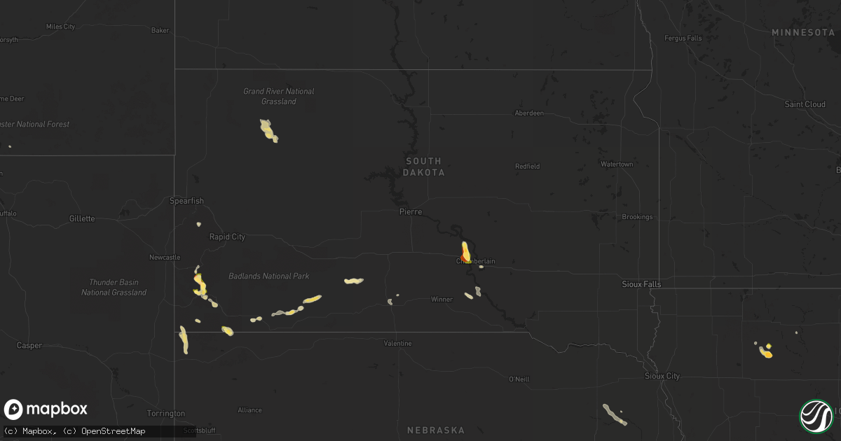
Hail Map in South Dakota on August 24, 2022
Get this storm
August 24 map
$229
one time, instant access
Download today. No call, no setup
Keep the $229
Bought the map and want the full workflow? Apply the entire $229 to a subscription within 7 days. None of it is wasted.
Every map, not just this one
This buys you this map. Subscription and you get every map we run, in the markets you choose from a few cities to whole states to nationwide. Plus real-time alerts the moment a storm fires.
Contact data
Name, contact info, occupancy, even credit band for addresses in the footprint. You go from where it hit to who to call.
Become the source they trust
Unlimited branding weather history reports on demand. You already have the documented answer ready for the property owner, and you are the one who showed up with it.
Property data and RoofTrace estimates
Pull up any address you have got, its value and the exact code rules for that jurisdiction, straight from One Click Code. Then RoofTrace estimates the squares, pitch, and roof value, priced the way you price.
Storm reports in South Dakota
South Dakota
| Date | Description |
|---|---|
| 08/24/20223:10 PM CDT | A local report indicates 1.50 inch wind near 1 NE ARGYLE |
| 08/24/20223:00 AM CDT | At 800 PM CDT, a severe thunderstorm was located 7 miles south of Tailrace Rec Area, or 8 miles south of Fort Thompson, moving southeast at 20 mph. HAZARD...60 mph wind gusts and quarter size hail. SOURCE...Radar indicated. IMPACT...Hail damage to vehicles is expected. Expect wind damage to roofs, siding, and trees. Locations impacted include... Oacoma, Dude Ranch and Lake Francis Case. |
| 08/24/20222:17 AM CDT | At 717 PM MDT/817 PM CDT/, a severe thunderstorm was located 4 miles west of Corn Creek, or 21 miles southeast of Kadoka, moving southeast at 15 mph. HAZARD...Ping pong ball size hail and 60 mph wind gusts. SOURCE...Radar indicated. IMPACT...People and animals outdoors will be injured. Expect hail damage to roofs, siding, windows, and vehicles. Expect wind damage to roofs, siding, and trees. This severe thunderstorm will be near... Corn Creek around 830 PM CDT.Other locations in the path of this severe thunderstorm includeNorris and Black Pipe. |
| 08/23/202210:46 PM CDT | At 346 AM CDT, a severe thunderstorm was located near Iona, or 14 miles south of Oacoma, moving east at 25 mph. HAZARD...60 mph wind gusts and quarter size hail. SOURCE...Radar indicated. IMPACT...Hail damage to vehicles is expected. Expect wind damage to roofs, siding, and trees. This severe thunderstorm will be near... Iona around 355 AM CDT. |
| 08/23/20229:57 PM CDT | At 257 PM MDT, a severe thunderstorm was located 3 miles southeast of Cottonwood Springs Dam, or 4 miles southwest of Hot Springs, moving southeast at 10 mph. HAZARD...60 mph wind gusts and quarter size hail. SOURCE...Radar indicated. IMPACT...Hail damage to vehicles is expected. Expect wind damage to roofs, siding, and trees. This severe thunderstorm will be near... Hot Springs around 310 PM MDT.Other locations in the path of this severe thunderstorm includeMaverick Junction, Angostura Reservoir and Oral. |
| 08/23/20228:43 PM CDT | At 142 PM MDT, a severe thunderstorm was located 3 miles south of Pringle, or 10 miles northwest of Hot Springs, moving southeast at 10 mph. HAZARD...60 mph wind gusts and half dollar size hail. SOURCE...Radar indicated. IMPACT...Hail damage to vehicles is expected. Expect wind damage to roofs, siding, and trees. This severe thunderstorm will be near... Southwestern Wind Cave National Park around 155 PM MDT.Other locations in the path of this severe thunderstorm include ColdBrook Reservoir, Cottonwood Springs Dam and Hot Springs. |
| 08/23/20228:25 PM CDT | Mesonet station ocms2 oacoma 2w |
All States Impacted by Hail Map on August 24, 2022
Cities Impacted by Hail Map on August 24, 2022
- Pavillion, WY
- Thermopolis, WY
- Colbert, WA
- Saint Regis, MT
- Pukwana, SD
- Allen, SD
- Wanblee, SD
- Enterprise, OR
- Imnaha, OR
- Edgemont, SD
- Hot Springs, SD
- Custer, SD
- Twentynine Palms, CA
- Vidal, CA
- Havelock, IA
- Laurens, IA
- Pocahontas, IA
- Deadwood, SD
- Saint Helen, MI
- Roscommon, MI
- Pilger, NE
- Chadron, NE
- Oelrichs, SD
- Nipton, CA
- Elk City, ID
- Porcupine, SD
- Wounded Knee, SD
- Cody, WY
- Meeteetse, WY
- Pine Valley, CA
- Campo, CA
- Kaycee, WY
- Mission, SD
- Cibola, AZ
- Wellton, AZ
- Winterhaven, CA
- Bison, SD
- Meadow, SD
- Prairie City, SD
- Hunters, WA
- Fruitland, WA
- Harrison, NE
- Burke, SD
- Porterfield, WI
- Wallace, MI
- Darby, MT
- Reliance, SD
- Lower Brule, SD
- Marinette, WI
- Menominee, MI
- Wisdom, MT
- Wood, SD
- Joshua Tree, CA
- Landers, CA
- Marathon, IA
- Algona, IA
- Thermal, CA
- Decker, MT
- Pine Ridge, SD
- Oacoma, SD
- Wisner, NE
- Hoskins, NE
- Stanton, NE
- Lostine, OR
- Quartzsite, AZ
- Bouse, AZ
- Desert Center, CA
- Gregory, SD
- Chewelah, WA
- White River, SD
- Long Valley, SD
- Wickenburg, AZ
- Norris, SD
- Spring Grove, MN
- Manderson, SD
- Newberry Springs, CA
- Malta, ID
- North Port, FL
- Buffalo, SD
- Congress, AZ
- Happy Jack, AZ


