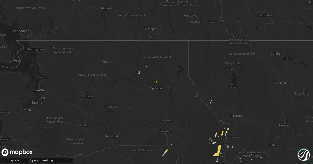
Hail Map on August 24, 2022
Get this storm
August 24 map
$229
one time, instant access
Download today. No call, no setup
Keep the $229
Bought the map and want the full workflow? Apply the entire $229 to a subscription within 7 days. None of it is wasted.
Every map, not just this one
This buys you this map. Subscription and you get every map we run, in the markets you choose from a few cities to whole states to nationwide. Plus real-time alerts the moment a storm fires.
Contact data
Name, contact info, occupancy, even credit band for addresses in the footprint. You go from where it hit to who to call.
Become the source they trust
Unlimited branding weather history reports on demand. You already have the documented answer ready for the property owner, and you are the one who showed up with it.
Property data and RoofTrace estimates
Pull up any address you have got, its value and the exact code rules for that jurisdiction, straight from One Click Code. Then RoofTrace estimates the squares, pitch, and roof value, priced the way you price.
States Impacted by Hail Map on August 24, 2022
Storm reports
Wyoming
| Date | Description |
|---|---|
| 08/24/20221:29 AM CDT | At 628 PM MDT, a severe thunderstorm was located 16 miles west of Meeteetse, moving southeast at 15 mph. HAZARD...Quarter size hail. SOURCE...Radar indicated. IMPACT...Damage to vehicles is expected. This severe thunderstorm will remain over mainly rural areas of southeastern Park County, including the following locations... Sunshine Reservoir. |
| 08/24/202212:56 AM CDT | At 556 PM MDT, a severe thunderstorm was located 16 miles east of Valley, or 21 miles west of Meeteetse, moving southeast at 20 mph. HAZARD...Quarter size hail. SOURCE...Radar indicated. IMPACT...Damage to vehicles is expected. This severe thunderstorm will remain over mainly rural areas of southeastern Park County. |
| 08/23/202210:46 PM CDT | At 345 PM MDT, a severe thunderstorm was located near Anchor Dam, or 25 miles north of Pavillion, moving southeast at 15 mph. HAZARD...Quarter size hail. SOURCE...Radar indicated. IMPACT...Damage to vehicles is expected. This severe thunderstorm will remain over mainly rural areas of southwestern Hot Springs and central Fremont Counties. |
Washington
| Date | Description |
|---|---|
| 08/24/20226:35 PM CDT | Downed tree limbs and numerous power outages near chewelah and areas to the southwest. Over 2000 people were without power. Time estimated from radar. |
| 08/24/202212:15 AM CDT | At 515 PM PDT, a severe thunderstorm was located 19 miles southwest of Chewelah, or 46 miles northwest of Spokane, moving northwest at 35 mph. HAZARD...Quarter size hail. SOURCE...Radar indicated. IMPACT...Damage to vehicles is expected. Locations impacted include... Cedonia. |
| 08/23/202211:51 PM CDT | At 451 PM PDT, a severe thunderstorm was located 21 miles southwest of Chewelah, or 42 miles northwest of Spokane, moving northwest at 20 mph. HAZARD...Quarter size hail. SOURCE...Radar indicated. IMPACT...Damage to vehicles is expected. Locations impacted include... Fruitland, Cedonia and Hunters. |
| 08/23/202211:30 PM CDT | At 430 PM PDT, a severe thunderstorm was located over Chewelah, or 41 miles west of Priest River, moving southeast at 10 mph. HAZARD...Half dollar size hail. SOURCE...Radar indicated. IMPACT...Damage to vehicles is expected. Locations impacted include... Chewelah and Valley. |
| 08/23/20228:12 PM CDT | Picture relayed to television media of hailstones estimated to be between the size of pennies and half dollars. Time estimated from radar. |
| 08/23/20227:25 PM CDT | Downed trees at a residence near route 25 and bissell road. Time estimated from radar. |
Idaho
| Date | Description |
|---|---|
| 08/24/20221:23 AM CDT | At 623 PM PDT, a severe thunderstorm was located 22 miles west of Victor, or 25 miles northwest of Hamilton, moving north at 25 mph. HAZARD...Ping pong ball size hail. SOURCE...Radar indicated. IMPACT...People and animals outdoors will be injured. Expect damage to roofs, siding, windows, and vehicles. Locations impacted include... Powell. |
| 08/23/20229:27 PM CDT | At 226 PM MDT, a severe thunderstorm was located 8 miles north of Malta, moving northeast at 15 mph. HAZARD...50 mph wind gusts and quarter size hail. SOURCE...Radar indicated. IMPACT...Hail damage to vehicles is expected. Expect wind damage to roofs, siding, and trees. Locations impacted include... Albion, Cold Water Rest Area, Yale Rest Area and Idahome. |
Montana
| Date | Description |
|---|---|
| 08/24/20225:26 AM CDT | At 1025 PM MDT, a severe thunderstorm was located 13 miles northeast of Belgrade, or 15 miles north of Bozeman, moving northeast at 20 mph. HAZARD...60 mph wind gusts. SOURCE...Radar indicated. IMPACT...Expect damage to roofs, siding, and trees. This severe thunderstorm will remain over mainly rural areas of southeastern Meagher and northeastern Gallatin Counties. |
| 08/24/20224:57 AM CDT | At 956 PM MDT, a severe thunderstorm was located 8 miles northeast of Belgrade, or 12 miles north of Bozeman, moving northeast at 30 mph. HAZARD...60 mph wind gusts. SOURCE...Observed at the Bozeman Airport. IMPACT...Expect damage to roofs, siding, and trees. Locations impacted include... Bozeman, Belgrade, Four Corners and Bozeman Hot Springs. |
| 08/23/202210:56 PM CDT | Asos station kbzn bozeman yellowstone airport. |
Nevada
| Date | Description |
|---|---|
| 08/23/20229:13 PM CDT | At 212 PM PDT, a severe thunderstorm was located near Mountain Springs, or near Red Rock Canyon, moving northeast at 15 mph. HAZARD...60 mph wind gusts. SOURCE...Radar indicated. IMPACT...Expect damage to roofs, trees, and power lines. Locations impacted include... Blue Diamond, Red Rock Canyon, Rocky Gap Campground, Mountain Springs, Lovell Canyon Campground, Spring Mountain Ranch, Sandy Valley and Mt. Potosi. |
Utah
| Date | Description |
|---|---|
| 08/23/20228:45 PM CDT | Emergency manager reported carport blown down. |
Iowa
| Date | Description |
|---|---|
| 08/24/20225:40 PM CDT | Reports of trees down in pocahontas with a few blocking roads. |
| 08/24/20225:35 PM CDT | Law enforcement reports golf ball hail just south of pocahontas near hwy 4. |
| 08/24/20225:32 PM CDT | Law enforcement reported golf ball hail roughly half mile west of pocahontas. |
| 08/24/202212:06 AM CDT | At 506 PM CDT, a severe thunderstorm was located near Laurens, or 7 miles north of Pocahontas, moving southeast at 15 mph. HAZARD...60 mph wind gusts and quarter size hail. SOURCE...Radar indicated. IMPACT...Hail damage to vehicles is expected. Expect wind damage to roofs, siding, and trees. This severe thunderstorm will be near... Havelock around 510 PM CDT. Plover around 515 PM CDT.Other locations in the path of this severe thunderstorm includePocahontas, Rolfe, Pocahontas Municipal Airport, Gilmore City andPalmer. |
Nebraska
| Date | Description |
|---|---|
| 08/24/202212:54 AM CDT | At 554 PM MDT, a severe thunderstorm was located near Harrison, or 28 miles east of Lusk, moving south at 25 mph. HAZARD...60 mph wind gusts and quarter size hail. SOURCE...Radar indicated. IMPACT...Hail damage to vehicles is expected. Expect wind damage to roofs, siding, and trees. Locations impacted include... Harrison. |
| 08/23/202211:18 PM CDT | At 418 PM MDT, a severe thunderstorm was located 11 miles northwest of Chadron Airport, or 15 miles northwest of Chadron, moving south at 15 mph. HAZARD...60 mph wind gusts and half dollar size hail. SOURCE...Radar indicated. IMPACT...Hail damage to vehicles is expected. Expect wind damage to roofs, siding, and trees. Locations impacted include... Chadron Airport. |
Arizona
| Date | Description |
|---|---|
| 08/24/20222:49 AM CDT | At 749 PM MST, a severe thunderstorm was located over Bouse, or 19 miles southeast of Parker, and is nearly stationary. HAZARD...60 mph wind gusts. SOURCE...Radar indicated. IMPACT...Expect damage to roofs, siding, and trees. Locations impacted include... Bouse.This includes the following highways...AZ Route 72 between mile markers 14 and 32.AZ Route 95 between mile markers 122 and 130. |
| 08/24/20221:53 AM CDT | At 652 PM MST/652 PM PDT/, severe thunderstorms were located along a line extending from near Brenda to 9 miles west of Nicholls Warm Springs, moving north at 15 mph. HAZARD...60 mph wind gusts. SOURCE...Radar indicated. IMPACT...Expect damage to roofs, siding, and trees. Locations impacted include... Blythe, Quartzsite, Nicholls Warm Springs, Brenda, Midland, Kofa Wildlife Refuge, Blythe Airport, Bouse, Ripley, East Blythe and Ehrenberg.This includes the following highways...AZ Interstate 10 between mile markers 1 and 41.CA Interstate 10 between mile markers 132 and 156.US Highway 60 between mile markers 31 and 43. |
| 08/24/20221:15 AM CDT | At 615 PM MST, a severe thunderstorm was located 10 miles northwest of Gladden, or 19 miles southeast of Alamo Lake, and is nearly stationary. HAZARD...60 mph wind gusts. SOURCE...Radar indicated. IMPACT...Expect damage to roofs, siding, and trees. This severe thunderstorm will remain over mainly rural areas of eastern La Paz County. |
| 08/24/20221:06 AM CDT | At 605 PM MST, a severe thunderstorm was located 8 miles northwest of Aguila, or 23 miles southeast of Alamo Lake, moving northeast at 15 mph. HAZARD...60 mph wind gusts and quarter size hail. SOURCE...Radar indicated. IMPACT...Hail damage to vehicles is expected. Expect wind damage to roofs, siding, and trees. This severe thunderstorm will remain over mainly rural areas of Yavapai County. |
| 08/23/20228:01 PM CDT | At 100 PM MST, a severe thunderstorm was located near Starlight Pines just east of Clints Well moving northwest at 5 mph. HAZARD...60 mph wind gusts and quarter size hail. SOURCE...Radar indicated. IMPACT...Hail damage to vehicles is expected. Expect wind damage to roofs, siding, and trees. Locations impacted include... Starlight Pines, Tremaine Lake, Blue Ridge Campground, Rock Crossing Campground, Chavez Mountain and Long Lake. |
Michigan
| Date | Description |
|---|---|
| 08/24/20223:22 PM CDT | Report of wires downed and a tree on a house in beaverton via emergency manager. Time estimated by radar. |
California
| Date | Description |
|---|---|
| 08/24/20226:37 PM CDT | Power poles knocked down and hanging by wires. |
| 08/24/20225:45 PM CDT | Site at newberry springs elementary school gusted to 58 mph at 345pm. Data courtesy of earth networks. Chp also reported telephone pole leaning with two transformers bl |
| 08/24/20222:47 AM CDT | At 744 PM PDT, a severe thunderstorm was located 18 miles north of Midland, or 25 miles southwest of Highway 95 At Mile Marker 29, moving north at 5 mph. HAZARD...60 mph wind gusts. SOURCE...Radar indicated. IMPACT...Expect damage to roofs and trees. Locations impacted include... SR-62 west of Vidal Junction. |
| 08/24/20221:02 AM CDT | At 601 PM PDT, a severe thunderstorm was located over Twentynine Palms Base, or near Twentynine Palms, moving northeast at 15 mph Blowing dust reducing visibilities to less than a mile is also possible with this storm. HAZARD...60 mph wind gusts. SOURCE...Radar indicated. IMPACT...Expect damage to roofs and trees. Locations impacted include... Twentynine Palms and Twentynine Palms Base. |
| 08/24/202212:59 AM CDT | At 559 PM PDT, a severe thunderstorm was located 16 miles east of Desert Center, moving north at 15 mph. HAZARD...60 mph wind gusts. SOURCE...Radar indicated. IMPACT...Expect damage to roofs, siding, and trees. This severe thunderstorm will remain over mainly rural areas of Riverside County.This includes the following highways...CA Interstate 10 between mile markers 111 and 137.CA Route 177 between mile markers 6 and 7. |
| 08/23/202211:42 PM CDT | At 441 PM PDT, a severe thunderstorm was located 13 miles northeast of Twentynine Palms Airport, or 21 miles east of Twentynine Palms, moving northeast at 30 mph. HAZARD...60 mph wind gusts. SOURCE...Radar indicated. IMPACT...Expect damage to roofs and trees. This severe thunderstorm will remain over mainly rural areas of south central San Bernardino County including Amboy Rd. |
| 08/23/202211:09 PM CDT | At 408 PM PDT, a severe thunderstorm was located over I-8 Between Boulevard And Imperial County Line, and is nearly stationary. An additional severe thunderstorm over southwest Imperial County could bring severe winds into the lower deserts of San Diego County. HAZARD...70 mph wind gusts and quarter size hail. SOURCE...Radar indicated. IMPACT...Hail damage to vehicles is expected. Expect considerable tree damage. Wind damage is also likely to mobile homes, roofs, and outbuildings. Locations impacted include... I-8 Between Boulevard And Imperial County Line, Hwy 78 Between S2 And Borrego Springs Rd, I-8 Between Pine Valley And Boulevard, Hwy S2 Vallecito Creek Rd, Hwy S2 Between Canebrake And Imperial County Line, Boulevard, Hwy S2 Between Agua Caliente And Canebrake, Fish Creek Wash, Hwy S2 Between Shelter Valley And Agua Caliente and Campo. |
| 08/23/202210:55 PM CDT | At 355 PM PDT, a severe thunderstorm was located 7 miles northwest of Plaster City, moving north at 15 mph. HAZARD...60 mph wind gusts and penny size hail. SOURCE...Radar indicated. IMPACT...Expect damage to roofs, siding, and trees. This severe thunderstorm will remain over mainly rural areas of west central Imperial County. |
| 08/23/20229:38 PM CDT | At 238 PM PDT, a severe thunderstorm was located 12 miles west of Sandy Valley, or 24 miles south of Pahrump, and is nearly stationary. HAZARD...60 mph wind gusts and quarter size hail. SOURCE...Radar indicated. IMPACT...Hail damage to vehicles is expected. Expect wind damage to roofs and trees. Locations impacted include... Sandy Valley. |
| 08/23/20229:03 PM CDT | 69 mph gust measured at blythe airport. |
| 08/23/20229:01 PM CDT | Overturned big rig in blythe. |
| 08/23/20228:52 PM CDT | Awos station kblh 7 nnw ripley. |
| 08/23/20228:27 PM CDT | At 127 PM PDT, a severe thunderstorm was located near I-8 Between Pine Valley And Boulevard, and is nearly stationary. HAZARD...60 mph wind gusts and quarter size hail. SOURCE...Radar indicated. IMPACT...Hail damage to vehicles is expected. Expect wind damage to roofs, siding, and trees. Locations impacted include... I-8 Between Pine Valley And Boulevard, I-8 Between Boulevard And Imperial County Line, Campo, Boulevard, Lake Morena, Tierra Del Sol, Campo Indian Reservation, La Posta Indian Reservation, Live Oak Springs and Manzanita Indian Reservation. |
| 08/23/20228:25 PM CDT | Overturned big rig truck on i-10. Sinkhole size of domestic truck nearby in fastlane @6:39pm. |
| 08/23/20227:24 PM CDT | Big rig tipped over on i-10. Weather caused. |
Florida
| Date | Description |
|---|---|
| 08/24/20225:27 PM CDT | Mesonet site located at charlotte harbor yacht club reported wind gust of 59 mph. |
| 08/24/20223:51 PM CDT | Public report relayed via amateur radio and social media of multiple trees down and a sign blown out in ybor city neighborhood near downtown tampa. Radar suggests a bri |
| 08/24/20221:02 AM CDT | At 602 PM EDT, severe thunderstorms were located along a line extending from near Babcock Webb Wma to near Palmona Park to Pine Manor, moving northwest at 20 mph. HAZARD...60 mph wind gusts and nickel size hail. SOURCE...Radar indicated. IMPACT...Expect damage to roofs, siding, and trees. Locations impacted include... Cape Coral, Fort Myers, North Port, Punta Gorda, Burnt Store Marina, Murdock, Fort Myers Villas, Harbour Heights, Tice and Palmona Park. |
South Dakota
| Date | Description |
|---|---|
| 08/24/20223:10 PM CDT | A local report indicates 1.50 inch wind near 1 NE ARGYLE |
| 08/24/20223:00 AM CDT | At 800 PM CDT, a severe thunderstorm was located 7 miles south of Tailrace Rec Area, or 8 miles south of Fort Thompson, moving southeast at 20 mph. HAZARD...60 mph wind gusts and quarter size hail. SOURCE...Radar indicated. IMPACT...Hail damage to vehicles is expected. Expect wind damage to roofs, siding, and trees. Locations impacted include... Oacoma, Dude Ranch and Lake Francis Case. |
| 08/24/20222:17 AM CDT | At 717 PM MDT/817 PM CDT/, a severe thunderstorm was located 4 miles west of Corn Creek, or 21 miles southeast of Kadoka, moving southeast at 15 mph. HAZARD...Ping pong ball size hail and 60 mph wind gusts. SOURCE...Radar indicated. IMPACT...People and animals outdoors will be injured. Expect hail damage to roofs, siding, windows, and vehicles. Expect wind damage to roofs, siding, and trees. This severe thunderstorm will be near... Corn Creek around 830 PM CDT.Other locations in the path of this severe thunderstorm includeNorris and Black Pipe. |
| 08/23/202210:46 PM CDT | At 346 AM CDT, a severe thunderstorm was located near Iona, or 14 miles south of Oacoma, moving east at 25 mph. HAZARD...60 mph wind gusts and quarter size hail. SOURCE...Radar indicated. IMPACT...Hail damage to vehicles is expected. Expect wind damage to roofs, siding, and trees. This severe thunderstorm will be near... Iona around 355 AM CDT. |
| 08/23/20229:57 PM CDT | At 257 PM MDT, a severe thunderstorm was located 3 miles southeast of Cottonwood Springs Dam, or 4 miles southwest of Hot Springs, moving southeast at 10 mph. HAZARD...60 mph wind gusts and quarter size hail. SOURCE...Radar indicated. IMPACT...Hail damage to vehicles is expected. Expect wind damage to roofs, siding, and trees. This severe thunderstorm will be near... Hot Springs around 310 PM MDT.Other locations in the path of this severe thunderstorm includeMaverick Junction, Angostura Reservoir and Oral. |
| 08/23/20228:43 PM CDT | At 142 PM MDT, a severe thunderstorm was located 3 miles south of Pringle, or 10 miles northwest of Hot Springs, moving southeast at 10 mph. HAZARD...60 mph wind gusts and half dollar size hail. SOURCE...Radar indicated. IMPACT...Hail damage to vehicles is expected. Expect wind damage to roofs, siding, and trees. This severe thunderstorm will be near... Southwestern Wind Cave National Park around 155 PM MDT.Other locations in the path of this severe thunderstorm include ColdBrook Reservoir, Cottonwood Springs Dam and Hot Springs. |
| 08/23/20228:25 PM CDT | Mesonet station ocms2 oacoma 2w |
Oregon
| Date | Description |
|---|---|
| 08/24/20221:45 AM CDT | At 643 PM PDT, a severe thunderstorm was located 17 miles east of Paradise, or 33 miles south of Lewiston, moving northeast at 30 mph. HAZARD...60 mph wind gusts and quarter size hail. SOURCE...Radar indicated. IMPACT...Hail damage to vehicles is expected. Expect wind damage to roofs, siding, and trees. Locations impacted include... Winchester aand much of the Snake River burnscar.This includes U.S. Highway 95 in Idaho between mile markers 274 and280. |
| 08/24/20221:28 AM CDT | At 628 PM PDT, a severe thunderstorm was located 13 miles southeast of Paradise, or 30 miles northeast of Enterprise, moving northeast at 25 mph. HAZARD...60 mph wind gusts and quarter size hail. SOURCE...Radar indicated. IMPACT...Hail damage to vehicles is expected. Expect wind damage to roofs, siding, and trees. This severe thunderstorm will remain over mainly rural areas of north central Wallowa County. |
Cities Impacted by Hail Map on August 24, 2022
- Pavillion, WY
- Thermopolis, WY
- Colbert, WA
- Saint Regis, MT
- Pukwana, SD
- Allen, SD
- Wanblee, SD
- Enterprise, OR
- Imnaha, OR
- Edgemont, SD
- Hot Springs, SD
- Custer, SD
- Twentynine Palms, CA
- Vidal, CA
- Havelock, IA
- Laurens, IA
- Pocahontas, IA
- Deadwood, SD
- Saint Helen, MI
- Roscommon, MI
- Pilger, NE
- Chadron, NE
- Oelrichs, SD
- Nipton, CA
- Elk City, ID
- Porcupine, SD
- Wounded Knee, SD
- Cody, WY
- Meeteetse, WY
- Pine Valley, CA
- Campo, CA
- Kaycee, WY
- Mission, SD
- Cibola, AZ
- Wellton, AZ
- Winterhaven, CA
- Bison, SD
- Meadow, SD
- Prairie City, SD
- Hunters, WA
- Fruitland, WA
- Harrison, NE
- Burke, SD
- Porterfield, WI
- Wallace, MI
- Darby, MT
- Reliance, SD
- Lower Brule, SD
- Marinette, WI
- Menominee, MI
- Wisdom, MT
- Wood, SD
- Joshua Tree, CA
- Landers, CA
- Marathon, IA
- Algona, IA
- Thermal, CA
- Decker, MT
- Pine Ridge, SD
- Oacoma, SD
- Wisner, NE
- Hoskins, NE
- Stanton, NE
- Lostine, OR
- Quartzsite, AZ
- Bouse, AZ
- Desert Center, CA
- Gregory, SD
- Chewelah, WA
- White River, SD
- Long Valley, SD
- Wickenburg, AZ
- Norris, SD
- Spring Grove, MN
- Manderson, SD
- Newberry Springs, CA
- Malta, ID
- North Port, FL
- Buffalo, SD
- Congress, AZ
- Happy Jack, AZ