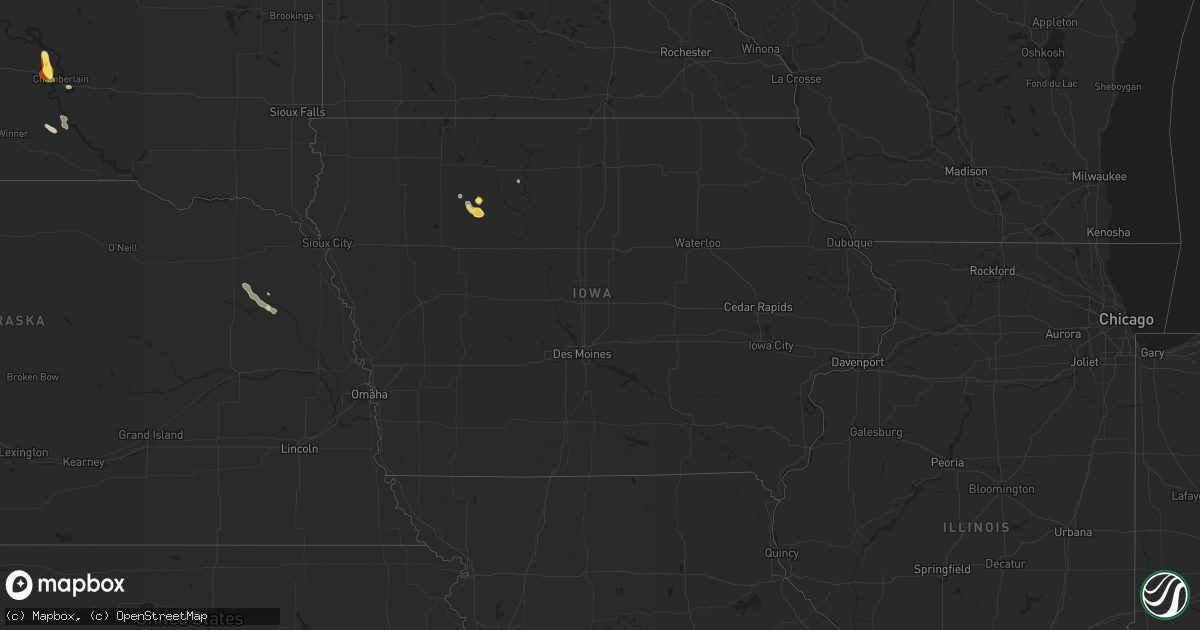
Hail Map in Iowa on August 24, 2022
Get this storm
August 24 map
$229
one time, instant access
Download today. No call, no setup
Keep the $229
Bought the map and want the full workflow? Apply the entire $229 to a subscription within 7 days. None of it is wasted.
Every map, not just this one
This buys you this map. Subscription and you get every map we run, in the markets you choose from a few cities to whole states to nationwide. Plus real-time alerts the moment a storm fires.
Contact data
Name, contact info, occupancy, even credit band for addresses in the footprint. You go from where it hit to who to call.
Become the source they trust
Unlimited branding weather history reports on demand. You already have the documented answer ready for the property owner, and you are the one who showed up with it.
Property data and RoofTrace estimates
Pull up any address you have got, its value and the exact code rules for that jurisdiction, straight from One Click Code. Then RoofTrace estimates the squares, pitch, and roof value, priced the way you price.
Storm reports in Iowa
Iowa
| Date | Description |
|---|---|
| 08/24/20225:40 PM CDT | Reports of trees down in pocahontas with a few blocking roads. |
| 08/24/20225:35 PM CDT | Law enforcement reports golf ball hail just south of pocahontas near hwy 4. |
| 08/24/20225:32 PM CDT | Law enforcement reported golf ball hail roughly half mile west of pocahontas. |
| 08/24/202212:06 AM CDT | At 506 PM CDT, a severe thunderstorm was located near Laurens, or 7 miles north of Pocahontas, moving southeast at 15 mph. HAZARD...60 mph wind gusts and quarter size hail. SOURCE...Radar indicated. IMPACT...Hail damage to vehicles is expected. Expect wind damage to roofs, siding, and trees. This severe thunderstorm will be near... Havelock around 510 PM CDT. Plover around 515 PM CDT.Other locations in the path of this severe thunderstorm includePocahontas, Rolfe, Pocahontas Municipal Airport, Gilmore City andPalmer. |
All States Impacted by Hail Map on August 24, 2022
Cities Impacted by Hail Map on August 24, 2022
- Pavillion, WY
- Thermopolis, WY
- Colbert, WA
- Saint Regis, MT
- Pukwana, SD
- Allen, SD
- Wanblee, SD
- Enterprise, OR
- Imnaha, OR
- Edgemont, SD
- Hot Springs, SD
- Custer, SD
- Twentynine Palms, CA
- Vidal, CA
- Havelock, IA
- Laurens, IA
- Pocahontas, IA
- Deadwood, SD
- Saint Helen, MI
- Roscommon, MI
- Pilger, NE
- Chadron, NE
- Oelrichs, SD
- Nipton, CA
- Elk City, ID
- Porcupine, SD
- Wounded Knee, SD
- Cody, WY
- Meeteetse, WY
- Pine Valley, CA
- Campo, CA
- Kaycee, WY
- Mission, SD
- Cibola, AZ
- Wellton, AZ
- Winterhaven, CA
- Bison, SD
- Meadow, SD
- Prairie City, SD
- Hunters, WA
- Fruitland, WA
- Harrison, NE
- Burke, SD
- Porterfield, WI
- Wallace, MI
- Darby, MT
- Reliance, SD
- Lower Brule, SD
- Marinette, WI
- Menominee, MI
- Wisdom, MT
- Wood, SD
- Joshua Tree, CA
- Landers, CA
- Marathon, IA
- Algona, IA
- Thermal, CA
- Decker, MT
- Pine Ridge, SD
- Oacoma, SD
- Wisner, NE
- Hoskins, NE
- Stanton, NE
- Lostine, OR
- Quartzsite, AZ
- Bouse, AZ
- Desert Center, CA
- Gregory, SD
- Chewelah, WA
- White River, SD
- Long Valley, SD
- Wickenburg, AZ
- Norris, SD
- Spring Grove, MN
- Manderson, SD
- Newberry Springs, CA
- Malta, ID
- North Port, FL
- Buffalo, SD
- Congress, AZ
- Happy Jack, AZ


