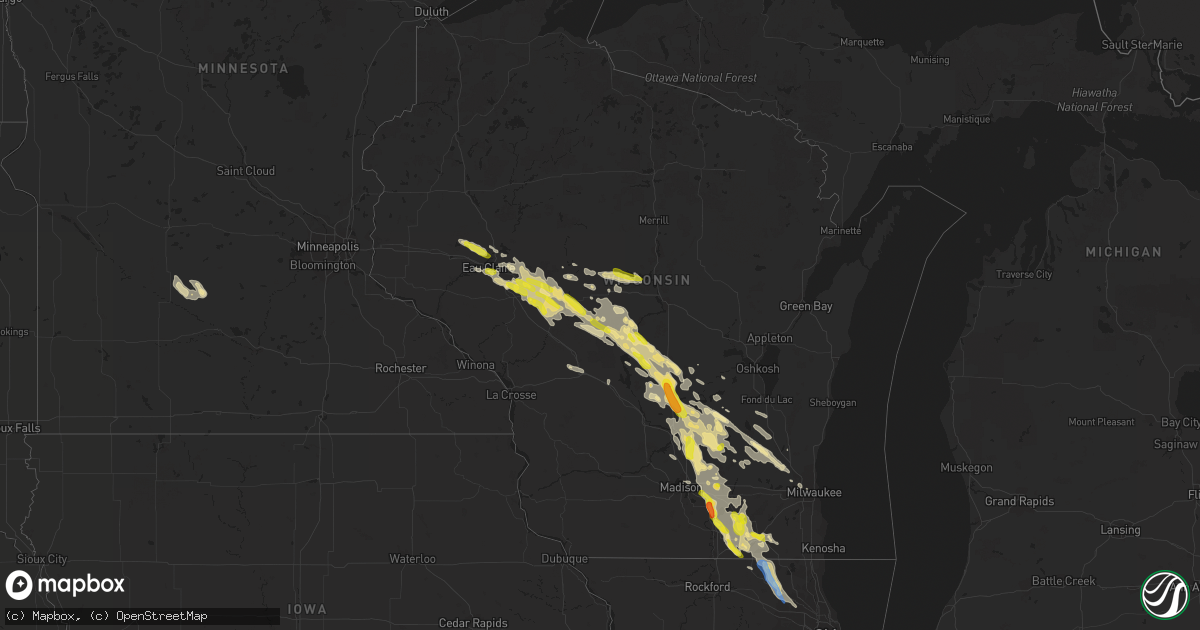
Hail Map in Wisconsin on August 24, 2020
Get this storm
August 24 map
$229
one time, instant access
Download today. No call, no setup
Keep the $229
Bought the map and want the full workflow? Apply the entire $229 to a subscription within 7 days. None of it is wasted.
Every map, not just this one
This buys you this map. Subscription and you get every map we run, in the markets you choose from a few cities to whole states to nationwide. Plus real-time alerts the moment a storm fires.
Contact data
Name, contact info, occupancy, even credit band for addresses in the footprint. You go from where it hit to who to call.
Become the source they trust
Unlimited branding weather history reports on demand. You already have the documented answer ready for the property owner, and you are the one who showed up with it.
Property data and RoofTrace estimates
Pull up any address you have got, its value and the exact code rules for that jurisdiction, straight from One Click Code. Then RoofTrace estimates the squares, pitch, and roof value, priced the way you price.
Storm reports in Wisconsin
Wisconsin
| Date | Description |
|---|---|
| 08/24/202011:59 AM CDT | Relayed from social media. Time estimated from radar. |
| 08/24/20206:59 AM CDT | At 1159 PM CDT, a severe thunderstorm was located over Fairchild, or 17 miles west of Neillsville, moving southeast at 25 mph. HAZARD...Quarter size hail. SOURCE...Radar indicated. IMPACT...Damage to vehicles is expected. This severe thunderstorm will be near... Humbird around 1210 AM CDT. Neillsville and Hatfield around 1235 AM CDT.Other locations impacted by this severe thunderstorm include EastFork Campground, Wildcat Mound, Highway 10 And 12, Highway 10 AndBald Peak Road, Lake Arbutus, Merrillan and Sidney. |
| 08/24/20206:59 AM CDT | At 1159 PM CDT, severe thunderstorms were located along a line extending from near Altoona to near Fairchild, moving east at 25 mph. HAZARD...Quarter size hail. SOURCE...Trained weather spotters. IMPACT...Damage to vehicles is expected. Severe thunderstorms will be near... Fairchild around 1205 AM CDT.Other locations impacted by these severe thunderstorms includeFoster, Brackett, Lake Eau Claire County Park, Ludington, Allen andSeymour. |
| 08/24/20206:47 AM CDT | At 1147 PM CDT, a severe thunderstorm was located over Westfield, or 15 miles southwest of Wautoma, moving southeast at 25 mph. HAZARD...60 mph wind gusts and quarter size hail. SOURCE...Radar indicated. IMPACT...Hail damage to vehicles is expected. Expect wind damage to roofs, siding, and trees. Locations impacted include... Montello, Markesan, Westfield, Princeton, Lawrence, Packwaukee, Manchester, Mecan, Neshkoro, Kingston, Marquette, Glen Oak, Harrisville, Springfield Corners and Dalton.This includes the following Location Puckaway Lake. |
| 08/24/20206:45 AM CDT | Delayed report. Most were pea to dime-sized... But a few looked quarter-sized. |
| 08/24/20206:23 AM CDT | At 1123 PM CDT, a severe thunderstorm was located near Sun Prairie, moving southeast at 35 mph. HAZARD...60 mph wind gusts and quarter size hail. SOURCE...Radar indicated. IMPACT...Hail damage to vehicles is expected. Expect wind damage to roofs, siding, and trees. Locations impacted include... Sun Prairie, Fort Atkinson, Windsor, Marshall, Deforest, Cottage Grove, Deerfield, Cambridge, Lake Ripley, Lake Koshkonong, Utica, Rockdale, Busseyville, Deansville, East Bristol, Morrisonville and Token Creek. |
| 08/24/20206:19 AM CDT | At 1118 PM CDT, a severe thunderstorm was located over Humbird, or 13 miles north of Black River Falls, moving southeast at 30 mph. HAZARD...Quarter size hail. SOURCE...Radar indicated. IMPACT...Damage to vehicles is expected. This severe thunderstorm will be near... Hatfield around 1140 PM CDT.Other locations impacted by this severe thunderstorm include EastFork Campground, Sand Pillow, Wildcat Mound, Highway 10 And 12, TheBlack River Correctional Center, Highway 10 And Bald Peak Road andLake Arbutus. |
| 08/24/20206:19 AM CDT | At 1119 PM CDT, a severe thunderstorm was located 11 miles north of Westfield, or 13 miles east of Friendship, moving southeast at 30 mph. HAZARD...60 mph wind gusts and quarter size hail. SOURCE...Radar indicated. IMPACT...Hail damage to vehicles is expected. Expect wind damage to roofs, siding, and trees. Locations impacted include... Wautoma, Dakota, Richford, Coloma and Hancock. |
| 08/24/20206:13 AM CDT | At 1112 PM CDT, a severe thunderstorm was located 9 miles southeast of New Rome, or 14 miles north of Friendship, moving southeast at 25 mph. HAZARD...Quarter size hail. SOURCE...Radar indicated. IMPACT...Damage to vehicles is expected. This severe thunderstorm will remain over mainly rural areas of northeastern Adams County, including the following locations... Lake Arrowhead, Colburn, The Colburn Wildlife Area, and The Leola Marsh Wildlife Area. |
| 08/24/20206:11 AM CDT | At 1110 PM CDT, a severe thunderstorm was located near Osseo, or 17 miles southeast of Eau Claire, moving southeast at 20 mph. HAZARD...Half dollar size hail. SOURCE...Radar indicated. IMPACT...Damage to vehicles is expected. This severe thunderstorm will be near... Augusta around 1130 PM CDT. Fairchild around 1155 PM CDT.Other locations impacted by this severe thunderstorm include Foster. |
| 08/24/20206:04 AM CDT | At 1104 PM CDT, a severe thunderstorm was located over New Rome, or 8 miles south of Wisconsin Rapids, moving southeast at 40 mph. HAZARD...60 mph wind gusts and quarter size hail. SOURCE...Radar indicated. IMPACT...Hail damage to vehicles is expected. Expect wind damage to roofs, siding, and trees. Locations impacted include... Nekoosa, Port Edwards, Cranmoor and Walker. |
| 08/24/20205:54 AM CDT | At 1053 PM CDT, a severe thunderstorm was located over Pardeeville, or 10 miles east of Portage, moving east at 30 mph. HAZARD...60 mph wind gusts and quarter size hail. SOURCE...Radar indicated. IMPACT...Hail damage to vehicles is expected. Expect wind damage to roofs, siding, and trees. Locations impacted include... Beaver Dam, Columbus, Pardeeville, Fall River, Rio, Cambria, Wyocena, Otsego, Doylestown, Danville and South Beaver Dam.This includes the following Location Alliant Energy Portage PowerPlant. |
| 08/24/20205:28 AM CDT | At 1028 PM CDT, a severe thunderstorm was located 7 miles northeast of Friendship, moving southeast at 35 mph. HAZARD...60 mph wind gusts and quarter size hail. SOURCE...Radar indicated. IMPACT...Hail damage to vehicles is expected. Expect wind damage to roofs, siding, and trees. This severe thunderstorm will remain over mainly rural areas of northeastern Juneau and northern Adams Counties, including the following locations... Arkdale, Lake Arrowhead, Colburn, and The Colburn Wildlife Area. |
| 08/24/20204:54 AM CDT | At 953 PM CDT, a severe thunderstorm was located 7 miles southwest of Plainfield, or 16 miles northeast of Friendship, moving southeast at 30 mph. HAZARD...60 mph wind gusts and quarter size hail. SOURCE...Public reported 1 inch hail near Nekoosa at 9:29 pm CDT. IMPACT...Hail damage to vehicles is expected. Expect wind damage to roofs, siding, and trees. Locations impacted include... Wautoma, Plainfield, Silver Lake, Dakota, Mount Morris, Richford, Coloma and Hancock. |
| 08/24/20204:46 AM CDT | At 944 PM CDT, a severe thunderstorm was located 7 miles southeast of New Rome, or 14 miles north of Friendship, moving southeast at 25 mph. HAZARD...60 mph wind gusts and quarter size hail. SOURCE...Public reported 1 inch hail near Nekoosa. IMPACT...Hail damage to vehicles is expected. Expect wind damage to roofs, siding, and trees. This severe thunderstorm will remain over mainly rural areas of north central Juneau and northern Adams Counties, including the following locations... New Miner, Lake Arrowhead, Colburn, and The Colburn Wildlife Area. |
| 08/24/20204:44 AM CDT | At 944 PM CDT, a severe thunderstorm was located over Babcock, or 13 miles southwest of Wisconsin Rapids, moving southeast at 30 mph. HAZARD...60 mph wind gusts and quarter size hail. SOURCE...Radar indicated. IMPACT...Hail damage to vehicles is expected. Expect wind damage to roofs, siding, and trees. Locations impacted include... Babcock, Nekoosa and Cranmoor. |
| 08/24/20203:08 AM CDT | Large branch on power lines. Time estimated on radar. |
| 08/24/20202:57 AM CDT | Relayed by law enforcement. Time estimated by radar. |
| 08/24/20202:55 AM CDT | Report of a tree down in the street and estimated winds estimated to 55 mph. |
| 08/24/20202:50 AM CDT | Reported at elkhorn - about 5 to 10 minutes of quarter sized hail. |
| 08/24/20202:45 AM CDT | Several trees down in the area. |
| 08/24/202012:53 AM CDT | Multiple reports of large limbs down... Tree damage... And a blown over chicken coop for areas in between janesville... Milton... And johnstown. Time estimated from rad |
| 08/24/202012:45 AM CDT | Report of a large tree down on a house in edgerton. Time estimated from radar. |
| 08/24/202012:25 AM CDT | A local report indicates 1.25 inch wind near 3 NW NEKOOSA |
| 08/24/202012:20 AM CDT | Report of 1 inch hail in packwaukee. |
| 08/23/202011:53 PM CDT | Picture on twitter. |
| 08/23/202011:51 PM CDT | Dane co. Dispatch has a report of a tree down in windsor. Time estimated from radar. |
| 08/23/202011:50 PM CDT | A local report indicates 1.00 inch wind near 2 SSW ALTOONA |
| 08/23/202011:43 PM CDT | Ping pong ball size hail reported. Time estimated from radar. |
| 08/23/202011:35 PM CDT | Delayed report: multiple large tree limbs down and a fallen tree reported via social media from this past monday storm. |
| 08/23/202011:20 PM CDT | Relayed from social media. |
| 08/23/202011:15 PM CDT | Picture via facebook. |
| 08/23/202011:06 PM CDT | Corrects previous tstm wnd dmg report from 2 sw doylestown. Corrects previous non-tstm wnd dmg report from 2 sw doylestown. Columbia co. Dispatch has reports of multipl |
| 08/23/202010:30 PM CDT | Several trees down and snapped off in saddle ridge estates neighborhood. Some trees also down in the northeast part of county... Including leeds township and cambria. |
| 08/23/202010:20 PM CDT | Delayed report. Time estimated from radar. |
| 08/23/20209:17 PM CDT | Report from mping. Time estimated by radar. |
All States Impacted by Hail Map on August 24, 2020
Cities Impacted by Hail Map on August 24, 2020
- Greenwood, WI
- Stoughton, WI
- Janesville, WI
- Edgerton, WI
- Sharon, WI
- Milton, WI
- Darien, WI
- Avalon, WI
- Cambridge, WI
- Clinton, WI
- Fort Atkinson, WI
- Augusta, WI
- Osseo, WI
- Fairchild, WI
- Markesan, WI
- Cambria, WI
- Fox Lake, WI
- Randolph, WI
- Columbus, WI
- Sun Prairie, WI
- Marshall, WI
- Deforest, WI
- Arlington, WI
- Rio, WI
- Poynette, WI
- Spencer, WI
- Chili, WI
- Pittsville, WI
- Necedah, WI
- Nekoosa, WI
- Arkdale, WI
- Willard, WI
- Franklin, MN
- Fairfax, MN
- Westfield, WI
- Oxford, WI
- Gibbon, MN
- Hector, MN
- Grand Marsh, WI
- Wisconsin Dells, WI
- Delavan, WI
- Butler, WI
- Brookfield, WI
- Milwaukee, WI
- Walworth, WI
- Burlington, WI
- Springfield, WI
- Lake Geneva, WI
- Elkhorn, WI
- Whitewater, WI
- Palmyra, WI
- Westfield, NY
- Eau Claire, WI
- Wisconsin Rapids, WI
- Stanley, WI
- Alma Center, WI
- Wautoma, WI
- Neshkoro, WI
- Lake Mills, WI
- Waterloo, WI
- Neillsville, WI
- Deerfield, WI
- Stratford, WI
- Waupun, WI
- Beaver Dam, WI
- Friendship, WI
- Coloma, WI
- Chippewa Falls, WI
- Elk Mound, WI
- Colfax, WI
- Olivia, MN
- Bird Island, MN
- Hebron, IL
- Woodstock, IL
- Wonder Lake, IL
- Babcock, WI
- Ripley, NY
- North East, PA
- Iron Ridge, WI
- Hartford, WI
- Rubicon, WI
- Horicon, WI
- Lodi, WI
- Dane, WI
- Adams, WI
- Montello, WI
- Marshfield, WI
- Auburndale, WI
- Hubertus, WI
- Colgate, WI
- Fall River, WI
- Pardeeville, WI
- Portage, WI
- Granton, WI
- Mosinee, WI
- Endeavor, WI
- Packwaukee, WI
- Hancock, WI
- Watertown, WI
- Dalton, WI
- Bancroft, WI
- Mchenry, IL
- Crystal Lake, IL
- Wyocena, WI
- Burnett, WI
- Harvard, IL
- Humbird, WI
- Fall Creek, WI
- Merrillan, WI
- Madison, WI
- Berlin, WI
- Hilton, NY
- Jefferson, WI
- Loyal, WI
- Cadott, WI
- Vesper, WI
- Arpin, WI
- Buffalo Lake, MN
- Lowell, WI
- Hustisford, WI
- Eleva, WI
- Neosho, WI
- Black River Falls, WI
- Port Edwards, WI
- Williams Bay, WI
- Lake In The Hills, IL
- Algonquin, IL
- Cottage Grove, WI
- Sussex, WI
- Barrington, IL
- Cary, IL
- Fox River Grove, IL
- Hoffman Estates, IL
- Richmond, IL
- Reeseville, WI
- Richfield, WI
- Fontana, WI
- Strum, WI
- Juneau, WI
- Palatine, IL
- Doylestown, WI
- Ringwood, IL
- Kingston, WI
- Brandon, WI
- New Lisbon, WI
- Tomah, WI
- Theresa, WI
- Allenton, WI
- Mayville, WI
- Owen, WI
- Brownsville, WI
- Lomira, WI
- Fond Du Lac, WI
- Oakfield, WI
- Menomonee Falls, WI
- West Bend, WI
- Lebanon, WI
- Ripon, WI
- Hewitt, WI
- Princeton, WI
- Carpentersville, IL
- Londonderry, NH
- Derry, NH
- Northfield, MA
- Winchester, NH
- Vernon, VT
- Hinsdale, NH
- East Hampton, CT
- Colchester, CT
- Portland, CT
- Cromwell, CT
- South Glastonbury, CT
- New Fairfield, CT
- Starksboro, VT
- Whitehall, NY
- Fair Haven, VT
- Huletts Landing, NY
- Clemons, NY
- Goffstown, NH
- Manchester, NH
- Rehoboth, MA
- Kents Hill, ME
- Canton, ME
- Livermore Falls, ME
- Jay, ME
- Skowhegan, ME
- Anson, ME
- Norridgewock, ME
- Naples, ME
- Sebago, ME
- Gardiner, ME
- Whitefield, ME
- Windham, ME
- Bristol, VT
- Poultney, VT
- Fredericksburg, VA
- Shickshinny, PA
- Plymouth, PA
- Wilkes Barre, PA
- Nanticoke, PA
- Wapwallopen, PA
- Hunlock Creek, PA
- Glen Lyon, PA
- Kingston, PA
- Mountain Top, PA
- Altoona, WI


