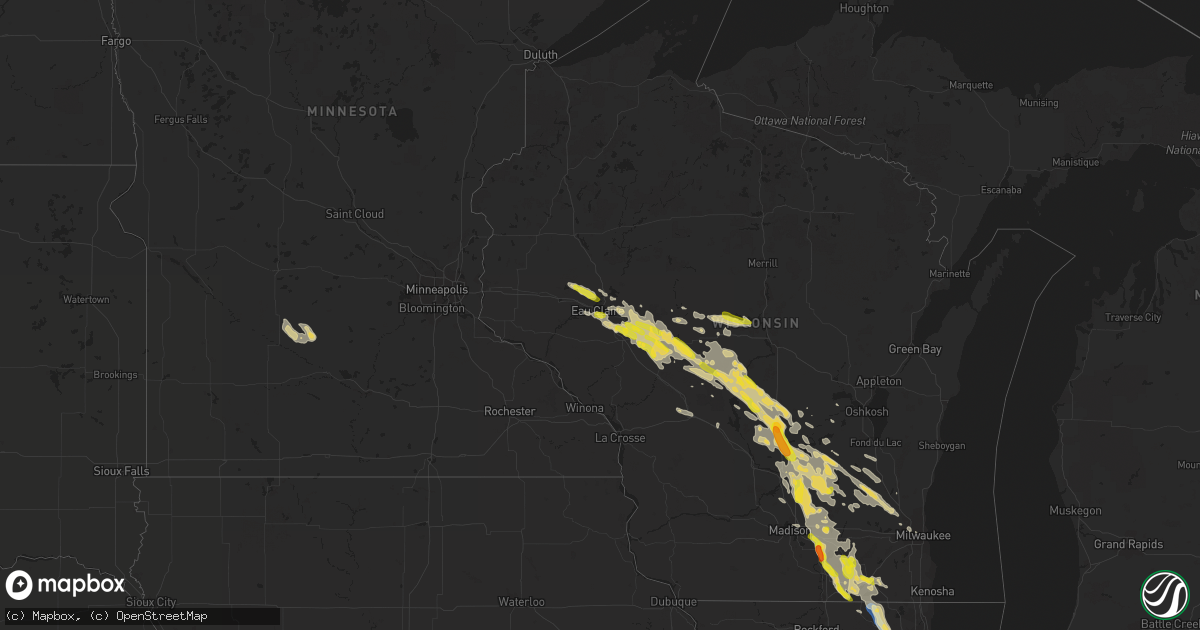
Hail Map on August 24, 2020
Get this storm
August 24 map
$229
one time, instant access
Download today. No call, no setup
Keep the $229
Bought the map and want the full workflow? Apply the entire $229 to a subscription within 7 days. None of it is wasted.
Every map, not just this one
This buys you this map. Subscription and you get every map we run, in the markets you choose from a few cities to whole states to nationwide. Plus real-time alerts the moment a storm fires.
Contact data
Name, contact info, occupancy, even credit band for addresses in the footprint. You go from where it hit to who to call.
Become the source they trust
Unlimited branding weather history reports on demand. You already have the documented answer ready for the property owner, and you are the one who showed up with it.
Property data and RoofTrace estimates
Pull up any address you have got, its value and the exact code rules for that jurisdiction, straight from One Click Code. Then RoofTrace estimates the squares, pitch, and roof value, priced the way you price.
States Impacted by Hail Map on August 24, 2020
Storm reports
Wisconsin
| Date | Description |
|---|---|
| 08/24/202011:59 AM CDT | Relayed from social media. Time estimated from radar. |
| 08/24/20206:59 AM CDT | At 1159 PM CDT, severe thunderstorms were located along a line extending from near Altoona to near Fairchild, moving east at 25 mph. HAZARD...Quarter size hail. SOURCE...Trained weather spotters. IMPACT...Damage to vehicles is expected. Severe thunderstorms will be near... Fairchild around 1205 AM CDT.Other locations impacted by these severe thunderstorms includeFoster, Brackett, Lake Eau Claire County Park, Ludington, Allen andSeymour. |
| 08/24/20206:59 AM CDT | At 1159 PM CDT, a severe thunderstorm was located over Fairchild, or 17 miles west of Neillsville, moving southeast at 25 mph. HAZARD...Quarter size hail. SOURCE...Radar indicated. IMPACT...Damage to vehicles is expected. This severe thunderstorm will be near... Humbird around 1210 AM CDT. Neillsville and Hatfield around 1235 AM CDT.Other locations impacted by this severe thunderstorm include EastFork Campground, Wildcat Mound, Highway 10 And 12, Highway 10 AndBald Peak Road, Lake Arbutus, Merrillan and Sidney. |
| 08/24/20206:47 AM CDT | At 1147 PM CDT, a severe thunderstorm was located over Westfield, or 15 miles southwest of Wautoma, moving southeast at 25 mph. HAZARD...60 mph wind gusts and quarter size hail. SOURCE...Radar indicated. IMPACT...Hail damage to vehicles is expected. Expect wind damage to roofs, siding, and trees. Locations impacted include... Montello, Markesan, Westfield, Princeton, Lawrence, Packwaukee, Manchester, Mecan, Neshkoro, Kingston, Marquette, Glen Oak, Harrisville, Springfield Corners and Dalton.This includes the following Location Puckaway Lake. |
| 08/24/20206:45 AM CDT | Delayed report. Most were pea to dime-sized... But a few looked quarter-sized. |
| 08/24/20206:23 AM CDT | At 1123 PM CDT, a severe thunderstorm was located near Sun Prairie, moving southeast at 35 mph. HAZARD...60 mph wind gusts and quarter size hail. SOURCE...Radar indicated. IMPACT...Hail damage to vehicles is expected. Expect wind damage to roofs, siding, and trees. Locations impacted include... Sun Prairie, Fort Atkinson, Windsor, Marshall, Deforest, Cottage Grove, Deerfield, Cambridge, Lake Ripley, Lake Koshkonong, Utica, Rockdale, Busseyville, Deansville, East Bristol, Morrisonville and Token Creek. |
| 08/24/20206:19 AM CDT | At 1119 PM CDT, a severe thunderstorm was located 11 miles north of Westfield, or 13 miles east of Friendship, moving southeast at 30 mph. HAZARD...60 mph wind gusts and quarter size hail. SOURCE...Radar indicated. IMPACT...Hail damage to vehicles is expected. Expect wind damage to roofs, siding, and trees. Locations impacted include... Wautoma, Dakota, Richford, Coloma and Hancock. |
| 08/24/20206:19 AM CDT | At 1118 PM CDT, a severe thunderstorm was located over Humbird, or 13 miles north of Black River Falls, moving southeast at 30 mph. HAZARD...Quarter size hail. SOURCE...Radar indicated. IMPACT...Damage to vehicles is expected. This severe thunderstorm will be near... Hatfield around 1140 PM CDT.Other locations impacted by this severe thunderstorm include EastFork Campground, Sand Pillow, Wildcat Mound, Highway 10 And 12, TheBlack River Correctional Center, Highway 10 And Bald Peak Road andLake Arbutus. |
| 08/24/20206:13 AM CDT | At 1112 PM CDT, a severe thunderstorm was located 9 miles southeast of New Rome, or 14 miles north of Friendship, moving southeast at 25 mph. HAZARD...Quarter size hail. SOURCE...Radar indicated. IMPACT...Damage to vehicles is expected. This severe thunderstorm will remain over mainly rural areas of northeastern Adams County, including the following locations... Lake Arrowhead, Colburn, The Colburn Wildlife Area, and The Leola Marsh Wildlife Area. |
| 08/24/20206:11 AM CDT | At 1110 PM CDT, a severe thunderstorm was located near Osseo, or 17 miles southeast of Eau Claire, moving southeast at 20 mph. HAZARD...Half dollar size hail. SOURCE...Radar indicated. IMPACT...Damage to vehicles is expected. This severe thunderstorm will be near... Augusta around 1130 PM CDT. Fairchild around 1155 PM CDT.Other locations impacted by this severe thunderstorm include Foster. |
| 08/24/20206:04 AM CDT | At 1104 PM CDT, a severe thunderstorm was located over New Rome, or 8 miles south of Wisconsin Rapids, moving southeast at 40 mph. HAZARD...60 mph wind gusts and quarter size hail. SOURCE...Radar indicated. IMPACT...Hail damage to vehicles is expected. Expect wind damage to roofs, siding, and trees. Locations impacted include... Nekoosa, Port Edwards, Cranmoor and Walker. |
| 08/24/20205:54 AM CDT | At 1053 PM CDT, a severe thunderstorm was located over Pardeeville, or 10 miles east of Portage, moving east at 30 mph. HAZARD...60 mph wind gusts and quarter size hail. SOURCE...Radar indicated. IMPACT...Hail damage to vehicles is expected. Expect wind damage to roofs, siding, and trees. Locations impacted include... Beaver Dam, Columbus, Pardeeville, Fall River, Rio, Cambria, Wyocena, Otsego, Doylestown, Danville and South Beaver Dam.This includes the following Location Alliant Energy Portage PowerPlant. |
| 08/24/20205:28 AM CDT | At 1028 PM CDT, a severe thunderstorm was located 7 miles northeast of Friendship, moving southeast at 35 mph. HAZARD...60 mph wind gusts and quarter size hail. SOURCE...Radar indicated. IMPACT...Hail damage to vehicles is expected. Expect wind damage to roofs, siding, and trees. This severe thunderstorm will remain over mainly rural areas of northeastern Juneau and northern Adams Counties, including the following locations... Arkdale, Lake Arrowhead, Colburn, and The Colburn Wildlife Area. |
| 08/24/20204:54 AM CDT | At 953 PM CDT, a severe thunderstorm was located 7 miles southwest of Plainfield, or 16 miles northeast of Friendship, moving southeast at 30 mph. HAZARD...60 mph wind gusts and quarter size hail. SOURCE...Public reported 1 inch hail near Nekoosa at 9:29 pm CDT. IMPACT...Hail damage to vehicles is expected. Expect wind damage to roofs, siding, and trees. Locations impacted include... Wautoma, Plainfield, Silver Lake, Dakota, Mount Morris, Richford, Coloma and Hancock. |
| 08/24/20204:46 AM CDT | At 944 PM CDT, a severe thunderstorm was located 7 miles southeast of New Rome, or 14 miles north of Friendship, moving southeast at 25 mph. HAZARD...60 mph wind gusts and quarter size hail. SOURCE...Public reported 1 inch hail near Nekoosa. IMPACT...Hail damage to vehicles is expected. Expect wind damage to roofs, siding, and trees. This severe thunderstorm will remain over mainly rural areas of north central Juneau and northern Adams Counties, including the following locations... New Miner, Lake Arrowhead, Colburn, and The Colburn Wildlife Area. |
| 08/24/20204:44 AM CDT | At 944 PM CDT, a severe thunderstorm was located over Babcock, or 13 miles southwest of Wisconsin Rapids, moving southeast at 30 mph. HAZARD...60 mph wind gusts and quarter size hail. SOURCE...Radar indicated. IMPACT...Hail damage to vehicles is expected. Expect wind damage to roofs, siding, and trees. Locations impacted include... Babcock, Nekoosa and Cranmoor. |
| 08/24/20203:08 AM CDT | Large branch on power lines. Time estimated on radar. |
| 08/24/20202:57 AM CDT | Relayed by law enforcement. Time estimated by radar. |
| 08/24/20202:55 AM CDT | Report of a tree down in the street and estimated winds estimated to 55 mph. |
| 08/24/20202:50 AM CDT | Reported at elkhorn - about 5 to 10 minutes of quarter sized hail. |
| 08/24/20202:45 AM CDT | Several trees down in the area. |
| 08/24/202012:53 AM CDT | Multiple reports of large limbs down... Tree damage... And a blown over chicken coop for areas in between janesville... Milton... And johnstown. Time estimated from rad |
| 08/24/202012:45 AM CDT | Report of a large tree down on a house in edgerton. Time estimated from radar. |
| 08/24/202012:25 AM CDT | A local report indicates 1.25 inch wind near 3 NW NEKOOSA |
| 08/24/202012:20 AM CDT | Report of 1 inch hail in packwaukee. |
| 08/23/202011:53 PM CDT | Picture on twitter. |
| 08/23/202011:51 PM CDT | Dane co. Dispatch has a report of a tree down in windsor. Time estimated from radar. |
| 08/23/202011:50 PM CDT | A local report indicates 1.00 inch wind near 2 SSW ALTOONA |
| 08/23/202011:43 PM CDT | Ping pong ball size hail reported. Time estimated from radar. |
| 08/23/202011:35 PM CDT | Delayed report: multiple large tree limbs down and a fallen tree reported via social media from this past monday storm. |
| 08/23/202011:20 PM CDT | Relayed from social media. |
| 08/23/202011:15 PM CDT | Picture via facebook. |
| 08/23/202011:06 PM CDT | Corrects previous tstm wnd dmg report from 2 sw doylestown. Corrects previous non-tstm wnd dmg report from 2 sw doylestown. Columbia co. Dispatch has reports of multipl |
| 08/23/202010:30 PM CDT | Several trees down and snapped off in saddle ridge estates neighborhood. Some trees also down in the northeast part of county... Including leeds township and cambria. |
| 08/23/202010:20 PM CDT | Delayed report. Time estimated from radar. |
| 08/23/20209:17 PM CDT | Report from mping. Time estimated by radar. |
Connecticut
| Date | Description |
|---|---|
| 08/24/20202:08 PM CDT | A local report indicates 1.00 inch wind near PORTLAND |
| 08/24/202012:47 PM CDT | Nickel to quarter sized hail reported. |
| 08/23/20209:59 PM CDT | At 259 PM EDT, a severe thunderstorm was located over Lake Pocotopaug--East Hampton, or over East Hampton, moving east at 15 mph. HAZARD...60 mph wind gusts and quarter size hail. SOURCE...Radar indicated. IMPACT...Minor hail damage to vehicles is possible. Expect wind damage to trees and power lines. This severe thunderstorm will be near... East Hampton and East Haddam around 320 PM EDT. Colchester around 340 PM EDT. Salem around 345 PM EDT. |
| 08/23/20209:39 PM CDT | At 239 PM EDT, a severe thunderstorm was located over Brookfield, or near Danbury, moving east at 15 mph. HAZARD...60 mph wind gusts and quarter size hail. SOURCE...Radar indicated. IMPACT...Minor hail damage to vehicles is possible. Expect wind damage to trees and power lines. This severe thunderstorm will be near... Brookfield around 245 PM EDT. Bethel around 250 PM EDT. Newtown around 305 PM EDT. Southbury and Monroe around 340 PM EDT. Seymour around 345 PM EDT. |
| 08/23/20208:53 PM CDT | At 152 PM EDT, severe thunderstorms were located along a line extending from near Colchester to near East Hampton, moving east at 15 mph. HAZARD...60 mph wind gusts and quarter size hail. SOURCE...Radar indicated. IMPACT...Minor hail damage to vehicles is possible. Expect wind damage to trees and power lines. Locations impacted include... Norwich, Colchester, East Hampton, Salem, Hartford, Portland, East Haddam, Haddam, Lebanon, Preston, Lisbon, Bozrah, Lake Pocotopaug--East Hampton, Montville and Franklin. |
North Dakota
| Date | Description |
|---|---|
| 08/24/20207:36 AM CDT | At 1236 AM CDT, a severe thunderstorm was located over Kidder, or 7 miles north of Britton, moving east at 50 mph. HAZARD...60 mph wind gusts and half dollar size hail. SOURCE...Radar indicated. IMPACT...Hail damage to vehicles is expected. Expect wind damage to roofs, siding, and trees. Locations impacted include... Britton, Veblen, Eden, Kidder, Lake City, Buffalo Lakes, Sica Hollow State Park, Cattail Lake, Clear Lake Rec Area, Piyas Lake, Hillhead, Fort Sisseton State Park, Veblen Flats Housing, Red Iron Housing, Roy Lake Rec Area and Opitz Lake. |
| 08/24/20207:30 AM CDT | At 1230 AM CDT, a severe thunderstorm was located near Tappen, or 11 miles east of Steele, moving southeast at 30 mph. HAZARD...Half dollar size hail. SOURCE...Radar indicated. IMPACT...Damage to vehicles is expected. This severe thunderstorm will remain over mainly rural areas of southeastern Kidder County. |
| 08/24/20207:21 AM CDT | At 1221 AM CDT, a severe thunderstorm was located near Oakes, or 57 miles south of Valley City, moving southeast at 35 mph. HAZARD...60 mph wind gusts and half dollar size hail. SOURCE...Radar indicated. IMPACT...Hail damage to vehicles is expected. Expect wind damage to roofs, siding, and trees. This severe thunderstorm will be near... Straubville around 1230 AM CDT. Brampton around 1240 AM CDT. Havana around 1245 AM CDT. |
| 08/24/20207:07 AM CDT | At 1206 AM CDT, a severe thunderstorm was located 8 miles northwest of Oakes, moving east at 20 mph. HAZARD...Half dollar size hail. SOURCE...Radar indicated. IMPACT...Damage to vehicles is expected. This severe thunderstorm will be near... Oakes around 1230 AM CDT.Other locations impacted by this severe thunderstorm include Glover. |
| 08/24/20207:02 AM CDT | At 1201 AM CDT, a severe thunderstorm was located near Stirum, or 44 miles south of Valley City, moving southeast at 40 mph. HAZARD...Quarter size hail. SOURCE...Radar indicated. IMPACT...Damage to vehicles is expected. This severe thunderstorm will be near... Stirum around 1210 AM CDT. Gwinner around 1215 AM CDT. Forman around 1225 AM CDT. Rutland around 1235 AM CDT. Cayuga around 1245 AM CDT. |
| 08/23/202010:39 PM CDT | At 339 AM CDT, a severe thunderstorm was located over Fort Ransom, or 27 miles south of Valley City, moving east at 40 mph. HAZARD...Half dollar size hail. SOURCE...Radar indicated. IMPACT...Damage to vehicles is expected. This severe thunderstorm will be near... Fort Ransom and Fort Ransom State Park around 345 AM CDT. Elliott around 355 AM CDT. Lisbon around 400 AM CDT. |
| 08/23/20208:55 PM CDT | At 154 AM CDT, a severe thunderstorm was located 6 miles northwest of Medina, moving east at 35 mph. HAZARD...60 mph wind gusts and half dollar size hail. SOURCE...Radar indicated. IMPACT...Hail damage to vehicles is expected. Expect wind damage to roofs, siding, and trees. This severe thunderstorm will be near... Medina around 205 AM CDT. Cleveland around 220 AM CDT.Other locations impacted by this severe thunderstorm include ChaseLake and Windsor. |
| 08/23/20208:46 PM CDT | At 146 AM CDT, a severe thunderstorm was located 6 miles southwest of Jamestown, moving east at 25 mph. HAZARD...Half dollar size hail. SOURCE...Radar indicated. IMPACT...Damage to vehicles is expected. This severe thunderstorm will be near... Jamestown around 155 AM CDT. Ypsilanti around 210 AM CDT. |
| 08/23/20208:03 PM CDT | At 101 AM CDT, a severe thunderstorm was located 5 miles north of Tappen, or 15 miles northeast of Steele, moving east at 25 mph. HAZARD...Half dollar size hail. SOURCE...Radar indicated. IMPACT...Damage to vehicles is expected. This severe thunderstorm will be near... Medina around 135 AM CDT. Cleveland around 145 AM CDT.Other locations impacted by this severe thunderstorm include CrystalSprings and Chase Lake. |
Oregon
| Date | Description |
|---|---|
| 08/24/20204:18 AM CDT | At 917 PM PDT, a severe thunderstorm was located near Paradise Valley, moving north at 45 mph. HAZARD...60 mph wind gusts. SOURCE...Radar indicated. IMPACT...Expect damage to roofs, siding, and trees. Small hail is also possible. Locations impacted include... Paradise Valley and McDermitt... State Route 140... |
New Jersey
| Date | Description |
|---|---|
| 08/24/20201:14 AM CDT | At 614 PM EDT, a severe thunderstorm was located over Springtown, or 7 miles south of Easton, moving southeast at 30 mph. HAZARD...60 mph wind gusts. SOURCE...Radar indicated. IMPACT...Damage to roofs, siding, trees, and power lines is possible. Locations impacted include... Easton, Bethlehem, Forks, Byram, Wilson, Hellertown, Flemington, Tinicum, New Hope, Alpha, Ferndale, Frenchtown, West Easton, Milford, Bloomsbury, Riegelsville, Stockton, Glendon, Pleasant Valley and Revere.This includes the following highways... Interstate 78 in Pennsylvania between mile markers 67 and 76. Interstate 78 in New Jersey between mile markers 0 and 6. |
Minnesota
| Date | Description |
|---|---|
| 08/23/202010:52 PM CDT | At 351 AM CDT, severe thunderstorms were located along a line extending from near Litchfield to near Cosmos to 6 miles north of Hector, moving east at 45 mph. HAZARD...60 mph wind gusts and quarter size hail. SOURCE...Radar indicated. IMPACT...Hail damage to vehicles is expected. Expect wind damage to roofs, siding, and trees. Severe thunderstorms will be near... Dassel around 400 AM CDT. Hutchinson and Cokato around 410 AM CDT. Howard Lake and Silver Lake around 420 AM CDT. Glencoe and Winsted around 425 AM CDT. Lester Prairie around 430 AM CDT.Other locations impacted by these severe thunderstorms include Greenleaf, Darwin, Biscay, Plato, Smith Lake and Lake Marion Regional Park. |
| 08/23/202010:13 PM CDT | At 313 AM CDT, severe thunderstorms were located along a line extending from 6 miles southwest of Belgrade to 7 miles northwest of Willmar to near Raymond to 9 miles north of Maynard, moving southeast at 45 mph. HAZARD...70 mph wind gusts and quarter size hail. SOURCE...Law enforcement. IMPACT...Hail damage to vehicles is expected. Expect considerable tree damage. Wind damage is also likely to mobile homes, roofs, and outbuildings. Severe thunderstorms will be near... Willmar around 320 AM CDT. New London and Spicer around 330 AM CDT. Prinsburg around 335 AM CDT. Atwater and Grove City around 345 AM CDT. Cosmos around 350 AM CDT. Litchfield, Olivia and Hector around 355 AM CDT. Bird Island and Buffalo Lake around 400 AM CDT.Other locations impacted by these severe thunderstorms include Kandiyohi, Strout, Thorpe, Corvuso, Blomkest, Lake Lillian, Greenleaf, Green Lake and Danube. |
| 08/23/20209:41 PM CDT | At 240 AM CDT, severe thunderstorms were located along a line extending from near Starbuck to Benson to near Milan, moving southeast at 45 mph. These are very dangerous storms. HAZARD...80 mph wind gusts and quarter size hail. SOURCE...At 240 AM, a 79 mph wind gust was reported in Benson. IMPACT...Flying debris will be dangerous to those caught without shelter. Mobile homes will be heavily damaged. Expect considerable damage to roofs, windows, and vehicles. Extensive tree damage and power outages are likely. Severe thunderstorms will be near... Murdock around 300 AM CDT. Kerkhoven around 305 AM CDT. Clara City, Raymond and Maynard around 320 AM CDT.Other locations impacted by these severe thunderstorms include Gilchrist, Swift Falls, Big Bend City, De Graff, Sunburg, Gluek, Priam and Pennock. |
| 08/23/20209:30 PM CDT | At 229 AM CDT, a severe thunderstorm was located over Hancock, or 7 miles southeast of Morris, moving southeast at 35 mph. HAZARD...60 mph wind gusts and quarter size hail. SOURCE...Radar indicated. IMPACT...Hail damage to vehicles is expected. Expect wind damage to roofs, siding, and trees. This severe thunderstorm will be near... Lake Hassel around 255 AM CDT.Other locations impacted by this severe thunderstorm include LakeEmily and Clontarf. |
| 08/23/20209:21 PM CDT | At 220 AM CDT, a severe thunderstorm was located over Artichoke, or 15 miles northeast of Ortonville, moving southeast at 35 mph. HAZARD...Ping pong ball size hail and 60 mph wind gusts. SOURCE...Radar indicated. IMPACT...People and animals outdoors will be injured. Expect hail damage to roofs, siding, windows, and vehicles. Expect wind damage to roofs, siding, and trees. This severe thunderstorm will be near... Lake Oliver around 235 AM CDT. Benson around 310 AM CDT.Other locations impacted by this severe thunderstorm include Danvers, Hagen, Appleton Airport, Clontarf and Holloway. |
| 08/23/20208:58 PM CDT | At 157 AM CDT, a severe thunderstorm was located over Trinity Lutheran Country Church, or 17 miles southeast of Wheaton, moving southeast at 25 mph. HAZARD...Ping pong ball size hail. SOURCE...Radar indicated. IMPACT...People and animals outdoors will be injured. Expect damage to roofs, siding, windows, and vehicles. This severe thunderstorm will be near... Chokio around 210 AM CDT. Lake Hattie around 225 AM CDT. Hancock around 250 AM CDT.Other locations impacted by this severe thunderstorm include Alberta and Fish Lake. |
Vermont
| Date | Description |
|---|---|
| 08/24/20204:11 PM CDT | Multiple trees down along state route 30 and blissville rd. |
| 08/24/20202:24 PM CDT | Cracked car windshield |
| 08/24/20202:24 PM CDT | Trees down at 17/jerusalem road |
| 08/24/20201:40 PM CDT | Several trees down on donaldson rd. |
| 08/24/20201:45 AM CDT | At 645 PM EDT, a severe thunderstorm was located over Whitehall, moving east at 10 mph. HAZARD...60 mph wind gusts and nickel size hail. SOURCE...Radar indicated. IMPACT...Expect damage to roofs, siding, and trees. Locations impacted include... Whitehall, Poultney Village, Mount Hope, Hampton, Lock Twelve Marina, Dresden Center, South Bay, Middle Granville, Low Hampton, North Granville, South Bay Village, Snody Dock, Clemons, Truthville, Raceville, Hampton Flats, Grays Corner, West Granville, East Whitehall and Iron Furnace. |
| 08/23/202011:43 PM CDT | At 443 PM EDT, a severe thunderstorm was located near Whitehall, moving east at 5 mph. HAZARD...Ping pong ball size hail and 60 mph wind gusts. SOURCE...Radar indicated. IMPACT...People and animals outdoors will be injured. Expect hail damage to roofs, siding, windows, and vehicles. Expect wind damage to roofs, siding, and trees. Locations impacted include... Whitehall, Hampton, Lock Twelve Marina, Dresden Center, Hampton Flats, Grays Corner, East Whitehall, Snody Dock, Clemons and Ottenburgs Ramp. |
| 08/23/202011:11 PM CDT | At 411 PM EDT, a severe thunderstorm was located 7 miles west of Benson Landing, moving east at 15 mph. HAZARD...60 mph wind gusts and quarter size hail. SOURCE...Radar indicated. IMPACT...Minor hail damage to vehicles is possible. Expect wind damage to trees and powerlines. Locations impacted include... Castleton, West Castleton, Sudbury, Hubbardton, Poultney Village, Lake St. Catherine, Benson, Poultney, Fair Haven, West Haven, Orwell, Brandon, Middletown Springs, Pittsford, Wells, Ira, West Rutland, Benson Bay, Hydeville and Bomoseen State Park. |
| 08/23/202011:00 PM CDT | At 400 PM EDT, a severe thunderstorm was located near West Haven, or 8 miles north of Whitehall, moving east at 10 mph. HAZARD...60 mph wind gusts and penny size hail. SOURCE...Radar indicated. IMPACT...Expect damage to roofs, siding, and trees. Locations impacted include... Whitehall, Hague, Rogers Rock Campground, Huletts Landing, Putnam, Wright, Hampton, Chipman Point, Low Hampton, Putnam Station, Snody Dock, Sabbath Day Point, Hampton Flats, Grays Corner, East Whitehall, Chipmans Point, Ottenburgs Ramp, North Bolton, Lock Twelve Marina and Dresden Center. |
| 08/23/202010:17 PM CDT | At 317 PM EDT, a severe thunderstorm was located over Paradox, moving east at 15 mph. HAZARD...60 mph wind gusts and quarter size hail. SOURCE...Radar indicated. IMPACT...Minor hail damage to vehicles is possible. Expect wind damage to trees and powerlines. Locations impacted include... Shoreham, Orwell, Benson, Bridport, Chipman Point, Benson Bay, Coates Point, Black Point, Grass Island, Beadles Cove, Larrabees Point, Lapham Bay, Fivemile Point, Chilson, Spar Mill Bay, Chipmans Point, Stony Cove, Paradox, Ironville and Mossy Point. |
| 08/23/202010:10 PM CDT | At 310 PM EDT, a severe thunderstorm was located over Starksboro, moving east at 20 mph. HAZARD...60 mph wind gusts and quarter size hail. SOURCE...Radar indicated. IMPACT...Minor hail damage to vehicles is possible. Expect wind damage to trees and powerlines. Locations impacted include... Warren, Moretown, Waitsfield, Starksboro, Fayston, Buels Gore, Huntington, Duxbury, Lincoln, Northfield, Roxbury, Granville, Monkton, Middlesex, Hinesburg, Bristol, Irasville, Huntington Center, South Duxbury and South Starksboro. |
| 08/23/20209:43 PM CDT | At 243 PM EDT, a severe thunderstorm was located near Northfield, or 10 miles northeast of Greenfield, moving southeast at 10 mph. HAZARD...60 mph wind gusts and quarter size hail. SOURCE...Radar indicated. IMPACT...Expect wind damage to trees and power lines. Minor hail damage to vehicles is possible. Locations impacted include... Orange, Northfield, Bernardston, Erving, Gill, Royalston, Wendell and Warwick. |
South Dakota
| Date | Description |
|---|---|
| 08/23/20209:56 PM CDT | At 256 AM CDT, a severe thunderstorm was located 8 miles southeast of Bitter Lake, or 18 miles southeast of Webster, moving east at 25 mph. HAZARD...60 mph wind gusts and quarter size hail. SOURCE...Radar indicated. IMPACT...Hail damage to vehicles is expected. Expect wind damage to roofs, siding, and trees. Locations impacted include... South Shore. |
| 08/23/20209:16 PM CDT | At 215 AM CDT, a severe thunderstorm was located near Roslyn, or 12 miles northwest of Webster, moving east at 20 mph. HAZARD...60 mph wind gusts and quarter size hail. SOURCE...Radar indicated. IMPACT...Hail damage to vehicles is expected. Expect wind damage to roofs, siding, and trees. Locations impacted include... Roslyn, Grenville, Pickerel Lake Rec Area, Piyas Lake and Waubay Lake. |
| 08/23/20209:08 PM CDT | At 207 AM CDT, a severe thunderstorm was located near Webster, moving east at 30 mph. HAZARD...60 mph wind gusts and half dollar size hail. SOURCE...Radar indicated. IMPACT...Hail damage to vehicles is expected. Expect wind damage to roofs, siding, and trees. Locations impacted include... Webster, Waubay, Ortley, Antelope Lake, Rush Lake, Blue Dog Lake, Bitter Lake and Waubay Lake. |
| 08/23/20208:33 PM CDT | At 133 AM CDT, a severe thunderstorm was located over Andover, or 11 miles east of Groton, moving east at 25 mph. HAZARD...60 mph wind gusts and half dollar size hail. SOURCE...Radar indicated. IMPACT...Hail damage to vehicles is expected. Expect wind damage to roofs, siding, and trees. Locations impacted include... Pierpont and Andover. |
West Virginia
| Date | Description |
|---|---|
| 08/23/20209:38 PM CDT | At 238 PM EDT, a severe thunderstorm was located near Claylick, or 11 miles east of Hancock, moving southeast at 30 mph. HAZARD...60 mph wind gusts and quarter size hail. SOURCE...Radar indicated. IMPACT...Damaging winds will cause some trees and large branches to fall. This could injure those outdoors, as well as damage homes and vehicles. Roadways may become blocked by downed trees. Localized power outages are possible. Unsecured light objects may become projectiles. Locations impacted include... Hagerstown, Municipal Stadium, Robinwood, Fountainhead-Orchard Hills, Boonsboro, Smithsburg, Paramount-Long Meadow, Wilson-Conococheague, Williamsport, Mount Aetna, Mount Lena, San Mar, Long Meadow, Wolfsville, Saint James, Halfway, Maugansville, Myersville, Cavetown and Funkstown. |
District of Columbia
| Date | Description |
|---|---|
| 08/23/20208:39 PM CDT | At 139 PM EDT, a severe thunderstorm was located over Franconia, or over Springfield, moving east at 15 mph. HAZARD...60 mph wind gusts. SOURCE...Radar indicated. IMPACT...Damaging winds will cause some trees and large branches to fall. This could injure those outdoors, as well as damage homes and vehicles. Roadways may become blocked by downed trees. Localized power outages are possible. Unsecured light objects may become projectiles. Locations impacted include... Alexandria, Annandale, Clinton, Springfield, Fort Washington, Fort Hunt, Groveton, Huntington, Fort Belvoir, National Harbor, Lincolnia, Camp Springs, Franconia, Oxon Hill, Hybla Valley, Newington, Friendly, Temple Hills, Marlow Heights and I395 and I495 Interchange. |
South Carolina
| Date | Description |
|---|---|
| 08/24/20204:25 PM CDT | Tree down on hwy 17 near hwy 64. |
| 08/24/20203:55 PM CDT | Tree down on hwy 402 at hwy 52. Relayed from the media. |
| 08/24/202012:45 PM CDT | Tree down at hwy 321 and hwy 278 as per sc highway patrol. Time estimated by radar. |
Michigan
| Date | Description |
|---|---|
| 08/24/20201:47 PM CDT | A local report indicates 71 MPH wind near YPSILANTI |
| 08/24/20204:52 AM CDT | Photos on twitter and facebook of large healthy branches down and a rotten tree down. Reports of numerous trees and lines down in downtown niles area. Unconfirmed repor |
| 08/23/20209:54 PM CDT | At 254 PM EDT, a severe thunderstorm was located over Belleville, or near Romulus, moving east at 20 mph. HAZARD...60 mph wind gusts. SOURCE...Radar indicated. IMPACT...Expect damage to roofs, siding, and trees. This severe thunderstorm will be near... Romulus around 315 PM EDT. Flat Rock around 320 PM EDT. Taylor and Greenfield Village around 325 PM EDT. Trenton and Grosse Ile around 335 PM EDT. Wyandotte around 340 PM EDT.Other locations impacted by this severe thunderstorm includeBrownstown Township, Inkster, Melvindale, Gibraltar, SumpterTownship, New Boston, Riverview, Wayne, Willow and Ecorse. |
Nevada
| Date | Description |
|---|---|
| 08/24/20206:57 PM CDT | Mesonet station bspnv 12.4 ne wells |
Pennsylvania
| Date | Description |
|---|---|
| 08/24/20205:07 PM CDT | Downed trees and wires near easton road. Time estimated from radar. |
| 08/24/20205:03 PM CDT | Downed trees and wires in several locations in bethlehem twp. Time estimated from radar. |
| 08/24/20204:35 PM CDT | Two large trees down near the intersection of s oaks rd and e walker rd. Time estimated from radar. |
| 08/24/20204:04 PM CDT | Downed trees and wires near kunkletown road. Time estimated from radar. |
| 08/24/20203:55 PM CDT | At least one fire department call for a downed tree in eldred twp. Time estimated from radar. |
| 08/24/20203:53 PM CDT | Downed trees and wires near frable drive south of gilbert. Time estimated from radar. |
| 08/24/20203:50 PM CDT | Trees and wires down on stoney ridge rd. Time estimated from radar. |
| 08/24/20203:42 PM CDT | Downed trees and wires near woodchuck drive near trachsville. Time estimated from radar. |
| 08/24/20203:13 PM CDT | Multiple trees blocking road |
| 08/24/20203:13 PM CDT | Wires down... Numerous poles knocked down... Numerous trees down. |
| 08/24/20203:10 PM CDT | Wires down and pulled from house |
| 08/24/20203:03 PM CDT | Trees across road |
| 08/24/20201:30 PM CDT | Tree down on 18500 block of highway 87. |
| 08/24/20207:41 AM CDT | At 1241 PM EDT, a severe thunderstorm was located near Evans City, or 8 miles west of Butler, moving southeast at 15 mph. HAZARD...Wind gusts to 60 mph. SOURCE...Radar. IMPACT...Expect damage to trees and power lines, resulting in some power outages. Locations impacted include... Meridian... Oak Hills... Nixon... Connoquenessing... |
| 08/24/20207:19 AM CDT | At 1219 PM EDT, a severe thunderstorm was located over Rimersburg, moving east at 15 mph. HAZARD...Wind gusts to 60 mph. SOURCE...Radar. IMPACT...Expect damage to trees and power lines, resulting in some power outages. Locations impacted include... Rimersburg... New Bethlehem... Hawthorn... Distant... |
| 08/23/202011:38 PM CDT | At 437 PM EDT, a severe thunderstorm was located over McMichael, or 10 miles south of Mount Pocono, moving east at 35 mph. HAZARD...60 mph wind gusts and quarter size hail. SOURCE...Radar indicated. IMPACT...Minor damage to vehicles is possible. Wind damage to roofs, siding, trees, and power lines is possible. Locations impacted include... East Stroudsburg, Blairstown, Bangor, Pen Argyl, Wind Gap, Belvidere, Oxford, Hope, East Bangor, Stormville, Brodheadsville, Kunkletown, Werry Lake, Gilbert, Millbrook, Pocono Raceway, Delaware Water Gap, Tannersville, Rossland and Long Pond.This includes the following highways... Interstate 80 in Pennsylvania between mile markers 299 and 314. Interstate 80 in New Jersey between mile markers 0 and 13. |
| 08/23/202010:47 PM CDT | At 347 PM EDT, a severe thunderstorm was located over Shickshinny, or 10 miles northeast of Berwick, moving east at 15 mph. HAZARD...Quarter size hail. SOURCE...Radar indicated. IMPACT...Damage to vehicles is expected. Locations impacted include... Wilkes-Barre, Muhlenberg, Kingston, Nanticoke, Plymouth, Swoyersville, Edwardsville, Larksville, Forty Fort and Lehman. |
| 08/23/20208:53 PM CDT | At 153 PM EDT, a severe thunderstorm was located near Morris, moving east at 25 mph. HAZARD...60 mph wind gusts and quarter size hail. SOURCE...Radar indicated. IMPACT...Hail damage to vehicles is expected. Expect wind damage to trees, roofs, and siding. Locations impacted include... Ralston, Buttonwood and Ski Sawmill Ski Area. |
| 08/23/20208:15 PM CDT | At 115 PM EDT, a severe thunderstorm was located over Beltzville State Park, or 7 miles east of Lehighton, moving east at 10 mph. HAZARD...60 mph wind gusts and quarter size hail. SOURCE...Radar indicated. IMPACT...Minor damage to vehicles is possible. Wind damage to roofs, siding, trees, and power lines is possible. Locations impacted include... Northampton, Palmerton, Slatington, Bath, Walnutport, Danielsville, Kunkletown, Beltzville State Park, Saylorsburg, Rossland, Berlinsville, Beersville, Kresgeville, Bowmanstown, Parryville, Chapman, Trachsville and Fiddletown.This includes Northeast Extension between mile markers 72 and 74, andnear mile marker 77. |
Rhode Island
| Date | Description |
|---|---|
| 08/23/20208:43 PM CDT | At 142 PM EDT, a severe thunderstorm was located over Attleboro, or near Pawtucket, moving east at 15 mph. HAZARD...60 mph wind gusts and quarter size hail. SOURCE...Radar indicated. IMPACT...Expect wind damage to trees and power lines. Minor hail damage to vehicles is possible. Locations impacted include... Brockton, Taunton, North Attleborough, Bridgewater, Attleboro, Mansfield, Middleborough, Easton, Norton, East Bridgewater, Seekonk, Raynham, Rehoboth, Lakeville, Dighton, West Bridgewater and Berkley. |
Georgia
| Date | Description |
|---|---|
| 08/24/20206:34 PM CDT | Several trees down in the northern end of lowndes county via the ema lowndes facebook page. |
| 08/24/20206:25 PM CDT | Church steeple blew off along knights academy road. |
| 08/24/20206:25 PM CDT | Tree down blocking part of troupeville road. |
| 08/24/20206:15 PM CDT | Tree down on power line reported via social media. |
| 08/24/20206:15 PM CDT | The 1100 block of west gordon street had large pine trees broken at the top and blown over the power lines. At 1104 west gordon... Brick facade wall come down. |
| 08/24/202011:03 AM CDT | Report of wind damage with photos showing portions of a buildings siding and roofing lifted up and onto the street in downtown baxley. |
| 08/24/20206:46 AM CDT | At 1146 AM EDT, a severe thunderstorm was located near Jamestown, or 10 miles northwest of Blackshear, moving north at 25 mph. HAZARD...60 mph wind gusts. SOURCE...Radar indicated. IMPACT...Expect damage to roofs, siding, and trees. Locations impacted include... Baxley, Hazlehurst, Alma, Blackshear, Graham, Nicholls, Pebble Hill, Jamestown, West Green and Dixie Union. |
| 08/24/20203:00 AM CDT | At 800 PM EDT, a severe thunderstorm was located over Nicholls, or 9 miles west of Alma, moving north at 20 mph. HAZARD...60 mph wind gusts. SOURCE...Radar indicated. IMPACT...Expect damage to roofs, siding, and trees. Locations impacted include... Denton. |
| 08/24/20202:32 AM CDT | At 732 PM EDT, a severe thunderstorm was located near Nicholls, or 12 miles east of Douglas, moving north at 15 mph. HAZARD...60 mph wind gusts. SOURCE...Radar indicated. IMPACT...Expect damage to roofs, siding, and trees. Locations impacted include... Alma and Nicholls. |
| 08/24/20202:26 AM CDT | At 726 PM EDT, a severe thunderstorm was located over Statenville, moving north at 40 mph. HAZARD...60 mph wind gusts. SOURCE...Radar indicated. IMPACT...Expect damage to roofs, siding, and trees. Locations impacted include... Mayday. |
| 08/24/20202:19 AM CDT | At 719 PM EDT, severe thunderstorms were located along a line extending from near Statenville to I-75 At Exit 16 to near Quitman, moving north at 45 mph. HAZARD...60 mph wind gusts. SOURCE...Radar indicated. IMPACT...Expect damage to roofs, siding, and trees. Locations impacted include... Nashville, Lakeland, Adel, Valdosta, Hahira, Sparks, Ray City, I-75 At Exit 16, Moody Air Force Base, Remerton, Meigs, Morven, Cecil, Reed Bingham State Park, Barretts, New Lois, Massee, Greggs, Hansell and Allenville. |
| 08/23/20209:40 PM CDT | Emergency manager reporting over half a dozen downed trees in an area south of toombs central mostly in the area of us hwy 1 between hwys 56 and 147 late monday night |
| 08/23/20209:35 PM CDT | Emergency manager reported several trees down in the vidalia city limits monday night. |
Virginia
| Date | Description |
|---|---|
| 08/24/20206:46 PM CDT | Power-lines down along the 172 block of mount sterling drive. |
| 08/24/20206:45 PM CDT | Multiple large trees down all along sweeney circle due to strong winds associated with a thunderstorm. Storm debris scattered along roadways e.g leaves... Twigs... Bran |
| 08/24/20206:41 PM CDT | Power-lines reported down along the 120 block of ventura drive. |
| 08/24/20206:38 PM CDT | A tree down on power-line along the 1155 block of rainbow forest drive. |
| 08/24/20206:33 PM CDT | Trees and power lines down. |
| 08/24/20206:33 PM CDT | Power lines downed at intersection of enterprise drive and laxton road. |
| 08/24/20206:31 PM CDT | Power lines down. |
| 08/24/20206:30 PM CDT | Downed trees on sweeney circle. |
| 08/24/20205:59 PM CDT | 9 houses damaged with 1 roof collapsed in the lees park neighborhood. Specifically... The 5000 block of holley oak lane. 1 unfinished structure had associated debris im |
| 08/24/20205:58 PM CDT | Trees down blocking smith station rd at jefferson davis highway |
| 08/24/20205:40 PM CDT | Tree down on power line resulting in multiple power outages. Time estimated from radar data. |
| 08/24/20204:52 PM CDT | Trees down blocking a portion of jefferson davis highway in massaponax |
| 08/24/20204:06 PM CDT | Tree down on the 300 block of landsdowne road |
| 08/24/20204:06 PM CDT | Trees and powerlines down on the 3500 block of mine road |
| 08/24/20204:01 PM CDT | Tree down near the intersection of tignor lane and anderson street |
| 08/24/20203:55 PM CDT | Tree down on the 900 block of dahlgren road |
| 08/24/20203:53 PM CDT | Numerous reports of trees and powerlines down in the vicinity of the city of fredericksburg |
| 08/24/202012:45 PM CDT | Tree down near the intersection of paul spring road and rebecca drive. Time estimated from radar. |
| 08/24/202012:43 PM CDT | Road closed near the intersection of old keene mill road and hillside road due to downed powerlines. |
| 08/24/20202:14 AM CDT | At 713 PM EDT, a severe thunderstorm was located over Boonsboro, or near Forest, moving east at 15 mph. HAZARD...60 mph wind gusts. SOURCE...Radar indicated. IMPACT...Expect damage to roofs, siding, and trees. Locations impacted include... Lynchburg... Concord... Rustburg... Forest... Coleman Falls... Madison Heights... and Boonsboro.This includes The following Locations Liberty University andLynchburg Airport. |
| 08/24/20201:19 AM CDT | At 619 PM EDT, a severe thunderstorm was located over Massaponax, or 9 miles south of Fredericksburg, moving south at 15 mph. HAZARD...60 mph wind gusts and quarter size hail. SOURCE...Radar indicated. IMPACT...Damaging winds will cause some trees and large branches to fall. This could injure those outdoors, as well as damage homes and vehicles. Roadways may become blocked by downed trees. Localized power outages are possible. Unsecured light objects may become projectiles. Locations impacted include... Massaponax, Spotsylvania, Thornburg and Snell. |
| 08/24/202012:08 AM CDT | At 508 PM EDT, a severe thunderstorm was located 8 miles northwest of Fredericksburg, moving southeast at 20 mph. HAZARD...60 mph wind gusts and nickel size hail. SOURCE...Radar indicated. IMPACT...Expect damage to trees and powerlines. This severe thunderstorm will remain over mainly rural areas of northeastern Caroline County, including the following locations... Rappahannock Academy, Sparta, Villboro, Woodford, Guinea and Corbin. |
| 08/23/202011:46 PM CDT | At 446 PM EDT, a severe thunderstorm was located over Popes Creek, moving east at 20 mph. HAZARD...60 mph wind gusts and quarter size hail. SOURCE...Radar indicated. IMPACT...Damaging winds will cause some trees and large branches to fall. This could injure those outdoors, as well as damage homes and vehicles. Roadways may become blocked by downed trees. Localized power outages are possible. Unsecured light objects may become projectiles. Locations impacted include... Dahlgren, Nanjemoy Creek, Popes Creek, Port Tobacco River, Wicomico River, Wicomico, Mechanicsville, Cobb Island, Rock Point, Bushwood, Clements, Issue, Tompkinsville, Abell, Chaptico, Swan Point, Avenue, Faulkner, Loveville and Oakley. |
| 08/23/20209:31 PM CDT | At 231 PM EDT, a severe thunderstorm was located near Warrenton, moving east at 10 mph. HAZARD...60 mph wind gusts and quarter size hail. SOURCE...Radar indicated. IMPACT...Damaging winds will cause some trees and large branches to fall. This could injure those outdoors, as well as damage homes and vehicles. Roadways may become blocked by downed trees. Localized power outages are possible. Unsecured light objects may become projectiles. Locations impacted include... Warrenton, New Baltimore, Meadowville, Airlie, Broken Hill, Auburn and Casanova. |
| 08/23/20209:16 PM CDT | At 216 PM EDT, a severe thunderstorm was located over Big Meadows, or 13 miles northwest of Madison, moving southeast at 25 mph. HAZARD...60 mph wind gusts and quarter size hail. SOURCE...Radar indicated. IMPACT...Damaging winds will cause some trees and large branches to fall. This could injure those outdoors, as well as damage homes and vehicles. Roadways may become blocked by downed trees. Localized power outages are possible. Unsecured light objects may become projectiles. Locations impacted include... Culpeper, Madison, Big Meadows, Brightwood, Criglersville, Ida, Etlan, Oakpark, Haywood, Pratts, Syria, Aroda, Banco, Pine Grove, Reva, Fordsville, Graves Mill, Twymans Mill, Aylor and Leon. |
New York
| Date | Description |
|---|---|
| 08/24/20205:57 PM CDT | Trees down on wires on north mountain street and tree donw on mccotter street. Time estimated by radar. |
| 08/24/20205:55 PM CDT | Trees dowon on wies on glimore street and potter terrace. Time estimated by radar. |
| 08/24/20205:05 PM CDT | Tree down route 4 and route 21. Time estimated by radar. |
| 08/24/20204:05 PM CDT | Trees down north and south williams streets and county route 12. Tree was on vehicle on south williams. Time estimated by radar. |
| 08/24/20204:03 PM CDT | Numerous snapped and downed trees near skenesborough drive in whitehall. House nearby has roof damage. |
| 08/24/20204:02 PM CDT | Trees down on wires on route 12/upper turnpike rd. Time estimated by radar. |
| 08/24/20204:00 PM CDT | Trees downed on skenesborough drive in front off skenesborough ems building |
| 08/24/20203:50 PM CDT | Trees were reported down on bellamy... North... West... Saunders and kirtland streets and on railrad avenue. Tree down on a vehicle on kirtland. Time estimated by radar |
| 08/24/20203:45 PM CDT | Tree down on wires on county route 7 and blue goose road. Time estimated by radar. |
| 08/24/20202:22 PM CDT | Wires down near 201 stage road. |
| 08/24/20202:10 PM CDT | Approximately a dozen trees were uprooted... Or snapped on the property. |
| 08/24/20202:00 PM CDT | Trees and wires down on day hollow road. Time estimated from radar. |
| 08/24/20202:00 PM CDT | Trees and wires down on marshland road. Time estimated from radar. |
| 08/24/20203:11 AM CDT | Tree down blocking road in lakewood. Time estimated based upon radar. |
| 08/24/20201:41 AM CDT | Tree down on ridge rd blocking road |
| 08/24/20201:35 AM CDT | Powerlines down on rt 62 in hamburg. Time estimated based upon radar. |
| 08/24/20201:30 AM CDT | Several trees down on smith road in hamburg. From wivb. Time estimated based on radar. |
| 08/24/20201:04 AM CDT | Trees down on gowanda zoar road. Time and location estimated based on radar. |
| 08/24/202012:50 AM CDT | Trees down on richardson rd in gowanda. Time estimated based upon radar. |
| 08/24/202012:11 AM CDT | At 511 PM EDT, a severe thunderstorm was located near Poultney Village, moving southeast at 25 mph. HAZARD...60 mph wind gusts and quarter size hail. SOURCE...Radar indicated. IMPACT...Minor hail damage to vehicles is possible. Expect wind damage to trees and powerlines. Locations impacted include... Rutland, Pawlet, Poultney Village, Tinmouth, Middletown Springs, Danby, Lake St. Catherine, Rutland - Southern Vermont Airport, Poultney, Fair Haven, Clarendon, Ira, West Haven, Wells, Castleton, West Rutland, Wallingford, Shrewsbury, East Clarendon and Hydeville. |
| 08/23/202010:30 PM CDT | At 330 PM EDT, a severe thunderstorm was located over Spencer, or 12 miles north of Waverly, moving east at 15 mph. HAZARD...60 mph wind gusts and quarter size hail. SOURCE...Radar indicated. IMPACT...Hail damage to vehicles is expected. Expect wind damage to roofs, siding, and trees. Locations impacted include... Owego, Newark Valley, Candor, Spencer, North Spencer, West Candor, Catatonk, West Newark and Weltonville. |
| 08/23/20209:53 PM CDT | At 253 PM EDT, a severe thunderstorm was located near Apalachin, or near Owego, moving east at 20 mph. HAZARD...60 mph wind gusts and quarter size hail. SOURCE...Radar indicated. IMPACT...Hail damage to vehicles is expected. Expect wind damage to roofs, siding, and trees. Locations impacted include... Binghamton, Vestal, Johnson City, Endicott, Maine, Owego, Port Dickinson, Newark Valley, Greater Binghamton Airport and Apalachin. |
| 08/23/20209:07 PM CDT | At 206 PM EDT, a severe thunderstorm was located over West Beekmantown, moving east at 25 mph. HAZARD...60 mph wind gusts and quarter size hail. SOURCE...Radar indicated. IMPACT...Minor hail damage to vehicles is possible. Expect wind damage to trees and powerlines. Locations impacted include... Plattsburgh, Beekmantown, Georgia, Grand Isle, St. Albans Town, North Hero, Milton, South Hero, Georgia Center, St. Albans City, Colchester, Isle La Motte, Swanton, Young Island, Wilcox Point, Scott Point, Hazen Point, West Milton, Hen Island and Conner Bay. |
| 08/23/20207:50 PM CDT | Trees down along river road to the albany city line. |
Massachusetts
| Date | Description |
|---|---|
| 08/24/20202:10 PM CDT | Tree down on river road. |
| 08/24/20202:05 PM CDT | Multiple trees down on west road. |
| 08/24/20201:50 PM CDT | Tree down on main st. |
| 08/24/20201:35 PM CDT | Utility pole snapped with a tree down on the wires on tremont st. |
| 08/24/20201:00 PM CDT | Large tree falling on wires on oak street. |
| 08/24/20203:47 AM CDT | At 847 PM EDT, a severe thunderstorm was located over Rensselaer, moving east at 35 mph. HAZARD...60 mph wind gusts and quarter size hail. SOURCE...Radar indicated. IMPACT...Hail damage to vehicles is expected. Expect wind damage to roofs, siding, and trees. Locations impacted include... Albany, East Greenbush, North Adams, Rensselaer, Delmar, Adams, Williamstown, Cheshire, Stephentown, Berlin, Hancock, New Ashford, West Sand Lake, Averill Park, Wynantskill, North Greenbush, Sand Lake, Poestenkill, Lanesborough and East Nassau. |
| 08/23/202011:49 PM CDT | At 449 PM EDT, a severe thunderstorm was located over Simsbury, or 8 miles northwest of West Hartford, moving east at 15 mph. HAZARD...60 mph wind gusts and quarter size hail. SOURCE...Radar indicated. IMPACT...Expect wind damage to trees and power lines. Minor hail damage to vehicles is possible. Locations impacted include... Hartford, West Hartford, Manchester, East Hartford, Enfield, Glastonbury, Vernon, Windsor, Wethersfield, South Windsor, Farmington, Simsbury, Bloomfield, Avon, Suffield, East Longmeadow, Ellington, Windsor Locks, Coventry and Somers. |
| 08/23/202011:18 PM CDT | At 418 PM EDT, a severe thunderstorm was located over Derry, moving east at 15 mph. HAZARD...60 mph wind gusts and quarter size hail. SOURCE...Radar indicated. IMPACT...Hail damage to vehicles is expected. Expect wind damage to roofs, siding, and trees. Locations impacted include... Manchester, Nashua, Derry, Salem, Merrimack, Litchfield, Hudson, Pelham, Londonderry, Hampstead, Atkinson, Kingston, Chester, Danville, East Kingston, Hampton Falls, Kensington, Windham, Sandown and Plaistow.This includes Interstate 93 between mile markers 1 and 18. |
| 08/23/202010:54 PM CDT | At 354 PM EDT, a severe thunderstorm was located over Hudson, or near Nashua, moving east at 10 mph. HAZARD...60 mph wind gusts and quarter size hail. SOURCE...Radar indicated. IMPACT...Hail damage to vehicles is expected. Expect wind damage to roofs, siding, and trees. Locations impacted include... Nashua, Salem, Merrimack, Litchfield, Hudson, Pelham, Londonderry, Atkinson and Windham.This includes Interstate 93 between mile markers 1 and 8. |
| 08/23/20209:38 PM CDT | At 238 PM EDT, a severe thunderstorm was located near Hinsdale, or 17 miles southwest of Keene, moving east at 5 mph. HAZARD...60 mph wind gusts and quarter size hail. SOURCE...Radar indicated. IMPACT...Hail damage to vehicles is expected. Expect wind damage to roofs, siding, and trees. Locations impacted include... Winchester, Richmond and Hinsdale. |
Illinois
| Date | Description |
|---|---|
| 08/24/20203:36 AM CDT | A couple downed large trees between woodstock and bull valley. Distance estimated based on social media report. Time estimated using radar. |
Florida
| Date | Description |
|---|---|
| 08/24/20206:15 PM CDT | Trees reported down near county road 152 between jennings and jasper. Time of event based on radar. |
| 08/24/20205:55 PM CDT | Power outages due to fallen trees and limbs. |
| 08/24/20205:50 PM CDT | Power outages due to fallen trees and limbs. |
| 08/24/20205:17 PM CDT | A tree was reported down northwest part of live oak. |
| 08/24/20205:15 PM CDT | Trees reported down near county road 152 between jennings and jasper. |
| 08/24/20204:26 PM CDT | County emergency management reported trees and powerlines down throughout the areas of inverness... Henrnando... And beverly hills. Time estimated. |
| 08/24/20201:10 PM CDT | Earth networks site mmmch at nicklaus children hospital recorded a 60 mph wind gust associated with a quick-moving thunderstorm. |
| 08/24/202012:27 PM CDT | Mesonet station xtrp tarpon pt. |
| 08/24/20209:45 AM CDT | A severe thunderstorm wind gust of 65mph / 56 knots was recorded by the wxflow mesonet site xtky turkey point. |
| 08/24/20206:22 AM CDT | At 1121 AM EDT, a severe thunderstorm was located near Homestead Miami Speedway, moving northwest at 45 mph. HAZARD...60 mph wind gusts. SOURCE...Radar indicated. IMPACT...Expect damage to roofs, siding, and trees. Locations impacted include... Homestead, Turkey Point, Homestead Miami Speedway, Homestead General Airport and The Redland. |
| 08/24/20205:34 AM CDT | At 1033 AM EDT, a severe thunderstorm was located near Ocean Reef, or near Turkey Point, moving northwest at 50 mph. HAZARD...60 mph wind gusts. SOURCE...Radar indicated. IMPACT...Expect damage to roofs, siding, and trees. Locations impacted include... Homestead, Turkey Point, Homestead Miami Speedway, Homestead General Airport and The Redland. |
| 08/24/20202:08 AM CDT | At 708 PM EDT, a severe thunderstorm was located over Jasper, moving north at 40 mph. HAZARD...60 mph wind gusts. SOURCE...Radar indicated. IMPACT...Expect damage to roofs, siding, and trees. Locations impacted include... Jasper and Statenville. |
| 08/24/20201:58 AM CDT | At 658 PM EDT, a severe thunderstorm was located 9 miles north of Madison, moving north at 45 mph. HAZARD...60 mph wind gusts. SOURCE...Radar indicated. IMPACT...Expect damage to roofs, siding, and trees. Locations impacted include... Lake Park, Valdosta, I-75 At Exit 16, Remerton, Dasher, Twin Lakes, Cherry Lake, Pinetta, Valdosta Regional Airport, Kinderlou, I-75 At Exit 5, Nankin, Clyattville, Blue Springs, Hanson, I-75 At Exit 22, I-75 At Exit 11 and Naylor. |
| 08/24/20201:37 AM CDT | At 637 PM EDT, severe thunderstorms were located along a line extending from near Dowling Park to 13 miles southeast of Monticello, moving north at 45 mph. HAZARD...60 mph wind gusts. SOURCE...Radar indicated. IMPACT...Expect damage to roofs, siding, and trees. Locations impacted include... Monticello, Madison, Greenville, Lee, Alma, Dills, Ebb, Lamont, Hamburg, Pinetta, Eridu, Nash, Drifton, Lovett, Casa Blanco, Hanson, Sirmans, Shady Grove, Fincher and Iddo. |
| 08/24/20201:14 AM CDT | At 614 PM EDT, a severe thunderstorm was located near Live Oak, moving north at 30 mph. HAZARD...60 mph wind gusts. SOURCE...Radar indicated. IMPACT...Expect damage to roofs, siding, and trees. Locations impacted include... Live Oak, Jennings, Suwannee River State Park, Crossroads and Newburn. |
| 08/24/202012:25 AM CDT | At 525 PM EDT, a severe thunderstorm was located over Inverness Highlands North, or near Inverness, moving northwest at 30 mph. HAZARD...60 mph wind gusts. SOURCE...Radar indicated. IMPACT...Expect damage to roofs, siding, and trees. Locations impacted include... Inverness, Beverly Hills, Homosassa Springs, Inverness Highlands North, Black Diamond, Inverness Highlands South, Hernando, Arbor Lakes, Lecanto, Citronelle, Crystal Manor, Crystal Oaks, River Lakes Manor, Citrus Springs, Pine Ridge, Citrus Hills, Gospel Island and Brent Wood. |
| 08/23/202011:53 PM CDT | At 452 PM EDT, a severe thunderstorm was located 19 miles west of Rainbow Lakes Estates, moving northwest at 30 mph. HAZARD...60 mph wind gusts. SOURCE...Radar indicated. IMPACT...Expect damage to roofs, siding, and trees. Locations impacted include... Chiefland, Fowlers Bluff, Manattee Road and Otter Creek. |
| 08/23/202011:36 PM CDT | At 436 PM EDT, a severe thunderstorm was located 9 miles north of Muse, or 11 miles west of Palmdale, moving northwest at 50 mph. HAZARD...60 mph wind gusts. SOURCE...Radar indicated. IMPACT...Expect damage to roofs, siding, and trees. Locations impacted include... Muse. |
| 08/23/202010:18 PM CDT | At 317 PM EDT, severe thunderstorms were located along a line extending from Sunset Key to near Little Palm Island Resort to 17 miles southeast of Boot Key, moving north at 40 mph. A wind gust of 70 mph was observed in Key West. HAZARD...60 mph wind gusts. SOURCE...Radar indicated. IMPACT...Expect damage to roofs, siding, and trees. Locations in the warning include... Key West, Marathon, Bahia Honda Channel Bridge, Seven Mile Bridge, East End Of Seven Mile Bridge, Big Coppitt Key, Boca Chica Channel Bridge, Niles Channel Bridge, Spanish Harbor Channel Bridge and Boca Chica.This includes US 1 between mile markers 0 and 58. |
| 08/23/20208:50 PM CDT | At 149 PM EDT, severe thunderstorms were located along a line extending from 25 miles southeast of Key Biscayne to near Black Point, moving northwest at 55 mph. HAZARD...60 mph wind gusts. SOURCE...Radar indicated. IMPACT...Expect damage to roofs, siding, and trees. Locations impacted include... Miami, Hialeah, South Miami, Key Biscayne, Miami Beach and Coral Gables. |
Maryland
| Date | Description |
|---|---|
| 08/24/20201:13 AM CDT | At 613 PM EDT, a severe thunderstorm was located near Wicomico River, moving southeast at 20 mph. HAZARD...60 mph wind gusts and nickel size hail. SOURCE...Radar indicated. IMPACT...Expect damage to trees and powerlines. This severe thunderstorm will be near, Montross around 630 PM EDT. Coles Point around 650 PM EDT.Other locations impacted by this severe thunderstorm include Lerty,Currioman Landing, Mount Holly, Singerly, Peeds, Foneswood, StratfordHall, Potomac Mills, Erica and Piney Grove. |
| 08/24/202012:14 AM CDT | At 513 PM EDT, severe thunderstorms were located along a line extending from near Spotsylvania to near Port Royal, moving south at 30 mph. HAZARD...60 mph wind gusts and quarter size hail. SOURCE...Radar indicated. Reports of downed trees. IMPACT...Damaging winds will cause some trees and large branches to fall. This could injure those outdoors, as well as damage homes and vehicles. Roadways may become blocked by downed trees. Localized power outages are possible. Unsecured light objects may become projectiles. Locations impacted include... Fredericksburg, King George, Massaponax, Spotsylvania, Passapatanzy, Rollins Fork, Weedonville, Ninde, Thornburg, Lambs Creek, Sealston, Jersey, Shiloh, Dogue and Potomac Beach. |
| 08/24/202012:13 AM CDT | At 512 PM EDT, a severe thunderstorm was located over Colonial Beach, moving southeast at 20 mph. HAZARD...60 mph wind gusts and nickel size hail. SOURCE...Radar indicated. IMPACT...Expect damage to trees and powerlines. This severe thunderstorm will remain over mainly rural areas of northwestern Westmoreland County, including the following locations... Lerty, Potomac Beach, Potomac Mills and Westmoreland State. |
| 08/23/202011:44 PM CDT | At 444 PM EDT, a severe thunderstorm was located over Fredericksburg, moving east at 20 mph. HAZARD...60 mph wind gusts and quarter size hail. SOURCE...Radar indicated. IMPACT...Damaging winds will cause some trees and large branches to fall. This could injure those outdoors, as well as damage homes and vehicles. Roadways may become blocked by downed trees. Localized power outages are possible. Unsecured light objects may become projectiles. Locations impacted include... Fredericksburg, Fairview Beach, Falmouth, Passapatanzy, Stones Corner, Leeland, White Oak, Sealston, Brookfield and Spring Valley. |
| 08/23/202010:29 PM CDT | At 327 PM EDT, a severe thunderstorm was located near Linton Hall, or 12 miles east of Warrenton, moving east at 20 mph. HAZARD...60 mph wind gusts and quarter size hail. SOURCE...Radar indicated. IMPACT...Damaging winds will cause some trees and large branches to fall. This could injure those outdoors, as well as damage homes and vehicles. Roadways may become blocked by downed trees. Localized power outages are possible. Unsecured light objects may become projectiles. Locations impacted include... Dale City, Springfield, Fort Hunt, Groveton, Fort Belvoir, Woodbridge, Lake Ridge, Burke, Linton Hall, Montclair, Lorton, Franconia, Hybla Valley, Bull Run, Newington, Triangle, Dumfries, Manassas, West Springfield and Sudley. |
| 08/23/202010:27 PM CDT | At 327 PM EDT, a severe thunderstorm was located 9 miles northwest of Stafford, moving east at 15 mph. HAZARD...60 mph wind gusts and quarter size hail. SOURCE...Radar indicated. IMPACT...Damaging winds will cause some trees and large branches to fall. This could injure those outdoors, as well as damage homes and vehicles. Roadways may become blocked by downed trees. Localized power outages are possible. Unsecured light objects may become projectiles. Locations impacted include... Stafford, Quantico, Aquia Creek, Triangle, Dumfries, Cherry Hill, Widewater, Roseville, Garrisonville, Arkendale, Ramoth, Heflin, Aquia and Ruby. |
| 08/23/20209:51 PM CDT | At 251 PM EDT, a severe thunderstorm was located over Fort Meade, or near Severn, moving east at 35 mph. HAZARD...60 mph wind gusts and quarter size hail. SOURCE...Radar indicated. IMPACT...Damaging winds will cause some trees and large branches to fall. This could injure those outdoors, as well as damage homes and vehicles. Roadways may become blocked by downed trees. Localized power outages are possible. Unsecured light objects may become projectiles. Locations impacted include... Columbia, Severn, Annapolis, Crofton, Elkridge, Riviera Beach, Naval Academy, Baltimore-Washington Airport, Severn River, Fort Smallwood State Park, Gibson Island, Bodkin Point, Sillery Bay, Magothy River, Dobbins Island, Pinehurst, Glen Burnie, Severna Park, Odenton and Laurel. |
Maine
| Date | Description |
|---|---|
| 08/24/20204:23 PM CDT | Mostly penny size hail... But a few quarter size stones fell. |
| 08/24/20204:17 PM CDT | A local report indicates 1.00 inch wind near 4 ENE SOUTH WINDHAM |
| 08/24/20203:55 PM CDT | Trees on wires. |
| 08/24/20203:45 PM CDT | A local report indicates 1.00 inch wind near 2 S POLAND |
| 08/24/20203:06 PM CDT | Swath of trees down near peaked mountain road. Likely microburst which was seen on wgme tower cam video. |
| 08/24/20203:00 PM CDT | Tree down across the road. Reported at peak mountain road sebago me. Time estimated by radar. |
| 08/24/20203:00 PM CDT | A local report indicates 1.00 inch wind near 4 N WHITEFIELD |
| 08/24/20201:20 PM CDT | A local report indicates 1.00 inch wind near 4 NNW FAYETTE |
| 08/24/20201:12 PM CDT | Trees and wires down. |
| 08/24/20201:12 PM CDT | Hail nearly to walnut size. Estimated winds 60 mph. At least some crop damage. Still assessing. |
| 08/24/20201:08 PM CDT | Tree down on wires across rt. 17 with smoke. Time estimated by radar. |
| 08/24/20201:00 PM CDT | A local report indicates 1.00 inch wind near JAY |
| 08/24/202012:27 PM CDT | Trees down. |
| 08/24/20201:14 AM CDT | At 614 PM EDT, a severe thunderstorm was located near Gray, or 11 miles north of Westbrook, moving east at 15 mph. HAZARD...60 mph wind gusts and quarter size hail. SOURCE...Radar indicated. IMPACT...Hail damage to vehicles is expected. Expect wind damage to roofs, siding, and trees. Locations impacted include... Cumberland, Gorham, Falmouth, Freeport, Gray, Yarmouth, Raymond, Standish, Durham, Windham, Pownal, North Yarmouth and New Gloucester.This includes the following highways... Interstate 295 between mile markers 11 and 20. Interstate 95 between mile markers 54 and 64. |
| 08/23/202011:57 PM CDT | At 457 PM EDT, a severe thunderstorm was located near Standish, or 8 miles northwest of Westbrook, moving southeast at 15 mph. HAZARD...60 mph wind gusts and quarter size hail. SOURCE...Radar indicated. IMPACT...Hail damage to vehicles is expected. Expect wind damage to roofs, siding, and trees. Locations impacted include... Portland, Westbrook, Cumberland, Gorham, Falmouth, Gray, Standish, Frye Island and Windham.This includes the following highways... Interstate 295 between mile markers 9 and 13. Interstate 95 between mile markers 49 and 58. |
| 08/23/202011:51 PM CDT | At 451 PM EDT, a severe thunderstorm was located 7 miles north of Gray, or 8 miles south of Mechanic Falls, moving southeast at 15 mph. HAZARD...60 mph wind gusts and quarter size hail. SOURCE...Radar indicated. IMPACT...Hail damage to vehicles is expected. Expect wind damage to roofs, siding, and trees. Locations impacted include... Lewiston, Gray, Lisbon, Durham, Pownal, New Gloucester, North Yarmouth and Poland.This includes Interstate 95 between mile markers 67 and 77. |
| 08/23/202011:21 PM CDT | At 420 PM EDT, a severe thunderstorm was located 7 miles west of Mechanic Falls, moving southeast at 15 mph. HAZARD...60 mph wind gusts and quarter size hail. SOURCE...Radar indicated. IMPACT...Hail damage to vehicles is expected. Expect wind damage to roofs, siding, and trees. Locations impacted include... Lewiston, Mechanic Falls, Gray, Raymond, Casco, Harrison, Poland, Minot, Oxford, Otisfield and New Gloucester.This includes Interstate 95 between mile markers 71 and 80. |
| 08/23/202011:06 PM CDT | At 406 PM EDT, a severe thunderstorm was located near Naples, moving southeast at 15 mph. HAZARD...Two inch hail and 60 mph wind gusts. SOURCE...Radar indicated. IMPACT...People and animals outdoors will be injured. Expect hail damage to roofs, siding, windows, and vehicles. Expect wind damage to roofs, siding, and trees. Locations impacted include... Naples, Cumberland, Gorham, Falmouth, Gray, Raymond, Standish, Casco, Frye Island, Windham, Sebago, Baldwin and North Yarmouth.This includes Interstate 95 between mile markers 58 and 65. This also includes... Sebago Lake. |
| 08/23/202010:50 PM CDT | At 349 PM EDT, a severe thunderstorm was located near Gardiner, moving southeast at 10 mph. HAZARD...Golf ball size hail and 70 mph wind gusts. SOURCE...Radar indicated. IMPACT...People and animals outdoors will be injured. Expect hail damage to roofs, siding, windows, and vehicles. Expect considerable tree damage. Wind damage is also likely to mobile homes, roofs, and outbuildings. Locations impacted include... Chelsea, Jefferson, Alna, Whitefield, Nobleboro, Newcastle, Windsor, Pittston, Somerville and Waldoboro. |
| 08/23/202010:38 PM CDT | At 336 PM EDT, a severe thunderstorm was located near Bridgton, moving southeast at 10 mph. HAZARD...60 mph wind gusts and quarter size hail. SOURCE...Radar indicated. IMPACT...Hail damage to vehicles is expected. Expect wind damage to roofs, siding, and trees. Locations impacted include... Bridgton, Naples, Hiram, Raymond, Casco, Denmark, Sebago and Baldwin.This also includes... Douglas Mountain. |
| 08/23/202010:14 PM CDT | At 314 PM EDT, a severe thunderstorm was located over Manchester, or over Augusta, moving southeast at 10 mph. HAZARD...60 mph wind gusts and quarter size hail. SOURCE...Radar indicated. IMPACT...Hail damage to vehicles is expected. Expect wind damage to roofs, siding, and trees. Locations impacted include... Augusta, Gardiner, Farmingdale, Manchester, Hallowell, Winthrop, Chelsea, Windsor, Somerville, Pittston, Whitefield and West Gardiner.This includes Interstate 95 between mile markers 104 and 113. |
| 08/23/20209:16 PM CDT | At 216 PM EDT, a severe thunderstorm was located over Norridgewock, or near Skowhegan, moving east at 25 mph. HAZARD...60 mph wind gusts and half dollar size hail. SOURCE...Radar indicated. IMPACT...Hail damage to vehicles is expected. Expect wind damage to roofs, siding, and trees. Locations impacted include... Fairfield, Skowhegan, Pittsfield, Madison, Clinton, Norridgewock, Benton, Canaan, Smithfield, Winslow and Mercer.This includes Interstate 95 between mile markers 132 and 141, andbetween mile markers 143 and 145. |
| 08/23/20209:04 PM CDT | At 204 PM EDT, a severe thunderstorm was located over Jay, or 12 miles south of Farmington, moving east at 20 mph. HAZARD...Golf ball size hail and 60 mph wind gusts. SOURCE...Radar indicated. IMPACT...People and animals outdoors will be injured. Expect hail damage to roofs, siding, windows, and vehicles. Expect wind damage to roofs, siding, and trees. Locations impacted include... Augusta, Oakland, Jay, Belgrade, Manchester, Chesterville, Fayette, Mount Vernon, Readfield, Vienna, Sidney and Rome. |
| 08/23/20208:45 PM CDT | At 144 PM EDT, a severe thunderstorm was located near Madison, or 10 miles northeast of Farmington, moving east at 15 mph. HAZARD...60 mph wind gusts and quarter size hail. SOURCE...Radar indicated. IMPACT...Hail damage to vehicles is expected. Expect wind damage to roofs, siding, and trees. Locations impacted include... Fairfield, Skowhegan, Madison, Norridgewock, Anson, Cornville, Industry, Starks, Mercer and Smithfield. |
| 08/23/20208:38 PM CDT | At 138 PM EDT, a severe thunderstorm was located near Dixfield, or 10 miles east of Rumford, moving east at 20 mph. HAZARD...60 mph wind gusts and quarter size hail. SOURCE...Radar indicated. IMPACT...Hail damage to vehicles is expected. Expect wind damage to roofs, siding, and trees. Locations impacted include... Jay, Livermore Falls, Dixfield, Canton, Wilton, Livermore, Chesterville and Carthage. |
| 08/23/20208:27 PM CDT | At 127 PM EDT, a severe thunderstorm was located 8 miles northwest of Madison, or 15 miles northwest of Skowhegan, moving east at 25 mph. HAZARD...60 mph wind gusts and quarter size hail. SOURCE...Radar indicated. IMPACT...Hail damage to vehicles is expected. Expect wind damage to roofs, siding, and trees. Locations impacted include... Skowhegan, Pittsfield, Madison, Norridgewock, Anson, Canaan, Hartland, Cornville, Athens, Embden, Harmony, Solon, Saint Albans and Palmyra. |
| 08/23/20208:06 PM CDT | At 106 PM EDT, a severe thunderstorm was located over Mexico, or over Rumford, moving east at 20 mph. HAZARD...60 mph wind gusts and quarter size hail. SOURCE...Radar indicated. IMPACT...Hail damage to vehicles is expected. Expect wind damage to roofs, siding, and trees. Locations impacted include... Rumford, Jay, Dixfield, Canton, Mexico, Wilton, Carthage, Town Of Washington, Peru, Perkins and Roxbury. |
New Hampshire
| Date | Description |
|---|---|
| 08/24/20203:18 PM CDT | A local report indicates 1.00 inch wind near DERRY |
| 08/24/20203:10 PM CDT | A local report indicates 1.25 inch wind near 1 NW DERRY |
| 08/24/20203:04 PM CDT | A local report indicates 1.25 inch wind near 3 S AUBURN |
| 08/24/20203:00 PM CDT | Trees down. |
| 08/24/20203:00 PM CDT | A local report indicates 1.00 inch wind near 2 N HUDSON |
| 08/24/20202:40 PM CDT | Trees down. |
| 08/24/20201:50 PM CDT | Trees down at burt hill rd. |
| 08/24/20201:29 AM CDT | At 629 PM EDT, a severe thunderstorm was located near Hooksett, or near Concord, moving east at 20 mph. HAZARD...60 mph wind gusts and quarter size hail. SOURCE...Radar indicated. IMPACT...Hail damage to vehicles is expected. Expect wind damage to roofs, siding, and trees. Locations impacted include... Concord, Hooksett, Hopkinton, Epsom, Bow, Allenstown, Deerfield, Candia, Dunbarton, Chichester and Pembroke.This includes the following highways... Interstate 293 near mile marker 11. Interstate 89 between mile markers 0 and 6. Interstate 93 between mile markers 25 and 39. |
Ohio
| Date | Description |
|---|---|
| 08/24/20204:05 PM CDT | Large tree limb and power pole downed across roadway. Time estimated from radar. |
| 08/24/202012:04 AM CDT | At 504 PM EDT, a severe thunderstorm was located near Wakeman, or 8 miles east of Norwalk, moving east at 30 mph. HAZARD...60 mph wind gusts. SOURCE...Radar indicated. IMPACT...Expect damage to trees and power lines. Locations impacted include... Grafton, Wellington, Wakeman, Oberlin, Lagrange, Penfield, Pittsfield and Kipton. |
Cities Impacted by Hail Map on August 24, 2020
- Greenwood, WI
- Stoughton, WI
- Janesville, WI
- Edgerton, WI
- Sharon, WI
- Milton, WI
- Darien, WI
- Avalon, WI
- Cambridge, WI
- Clinton, WI
- Fort Atkinson, WI
- Augusta, WI
- Osseo, WI
- Fairchild, WI
- Markesan, WI
- Cambria, WI
- Fox Lake, WI
- Randolph, WI
- Columbus, WI
- Sun Prairie, WI
- Marshall, WI
- Deforest, WI
- Arlington, WI
- Rio, WI
- Poynette, WI
- Spencer, WI
- Chili, WI
- Pittsville, WI
- Necedah, WI
- Nekoosa, WI
- Arkdale, WI
- Willard, WI
- Franklin, MN
- Fairfax, MN
- Westfield, WI
- Oxford, WI
- Gibbon, MN
- Hector, MN
- Grand Marsh, WI
- Wisconsin Dells, WI
- Delavan, WI
- Butler, WI
- Brookfield, WI
- Milwaukee, WI
- Walworth, WI
- Burlington, WI
- Springfield, WI
- Lake Geneva, WI
- Elkhorn, WI
- Whitewater, WI
- Palmyra, WI
- Westfield, NY
- Eau Claire, WI
- Wisconsin Rapids, WI
- Stanley, WI
- Alma Center, WI
- Wautoma, WI
- Neshkoro, WI
- Lake Mills, WI
- Waterloo, WI
- Neillsville, WI
- Deerfield, WI
- Stratford, WI
- Waupun, WI
- Beaver Dam, WI
- Friendship, WI
- Coloma, WI
- Chippewa Falls, WI
- Elk Mound, WI
- Colfax, WI
- Olivia, MN
- Bird Island, MN
- Hebron, IL
- Woodstock, IL
- Wonder Lake, IL
- Babcock, WI
- Ripley, NY
- North East, PA
- Iron Ridge, WI
- Hartford, WI
- Rubicon, WI
- Horicon, WI
- Lodi, WI
- Dane, WI
- Adams, WI
- Montello, WI
- Marshfield, WI
- Auburndale, WI
- Hubertus, WI
- Colgate, WI
- Fall River, WI
- Pardeeville, WI
- Portage, WI
- Granton, WI
- Mosinee, WI
- Endeavor, WI
- Packwaukee, WI
- Hancock, WI
- Watertown, WI
- Dalton, WI
- Bancroft, WI
- Mchenry, IL
- Crystal Lake, IL
- Wyocena, WI
- Burnett, WI
- Harvard, IL
- Humbird, WI
- Fall Creek, WI
- Merrillan, WI
- Madison, WI
- Berlin, WI
- Hilton, NY
- Jefferson, WI
- Loyal, WI
- Cadott, WI
- Vesper, WI
- Arpin, WI
- Buffalo Lake, MN
- Lowell, WI
- Hustisford, WI
- Eleva, WI
- Neosho, WI
- Black River Falls, WI
- Port Edwards, WI
- Williams Bay, WI
- Lake In The Hills, IL
- Algonquin, IL
- Cottage Grove, WI
- Sussex, WI
- Barrington, IL
- Cary, IL
- Fox River Grove, IL
- Hoffman Estates, IL
- Richmond, IL
- Reeseville, WI
- Richfield, WI
- Fontana, WI
- Strum, WI
- Juneau, WI
- Palatine, IL
- Doylestown, WI
- Ringwood, IL
- Kingston, WI
- Brandon, WI
- New Lisbon, WI
- Tomah, WI
- Theresa, WI
- Allenton, WI
- Mayville, WI
- Owen, WI
- Brownsville, WI
- Lomira, WI
- Fond Du Lac, WI
- Oakfield, WI
- Menomonee Falls, WI
- West Bend, WI
- Lebanon, WI
- Ripon, WI
- Hewitt, WI
- Princeton, WI
- Carpentersville, IL
- Londonderry, NH
- Derry, NH
- Northfield, MA
- Winchester, NH
- Vernon, VT
- Hinsdale, NH
- East Hampton, CT
- Colchester, CT
- Portland, CT
- Cromwell, CT
- South Glastonbury, CT
- New Fairfield, CT
- Starksboro, VT
- Whitehall, NY
- Fair Haven, VT
- Huletts Landing, NY
- Clemons, NY
- Goffstown, NH
- Manchester, NH
- Rehoboth, MA
- Kents Hill, ME
- Canton, ME
- Livermore Falls, ME
- Jay, ME
- Skowhegan, ME
- Anson, ME
- Norridgewock, ME
- Naples, ME
- Sebago, ME
- Gardiner, ME
- Whitefield, ME
- Windham, ME
- Bristol, VT
- Poultney, VT
- Fredericksburg, VA
- Shickshinny, PA
- Plymouth, PA
- Wilkes Barre, PA
- Nanticoke, PA
- Wapwallopen, PA
- Hunlock Creek, PA
- Glen Lyon, PA
- Kingston, PA
- Mountain Top, PA
- Altoona, WI