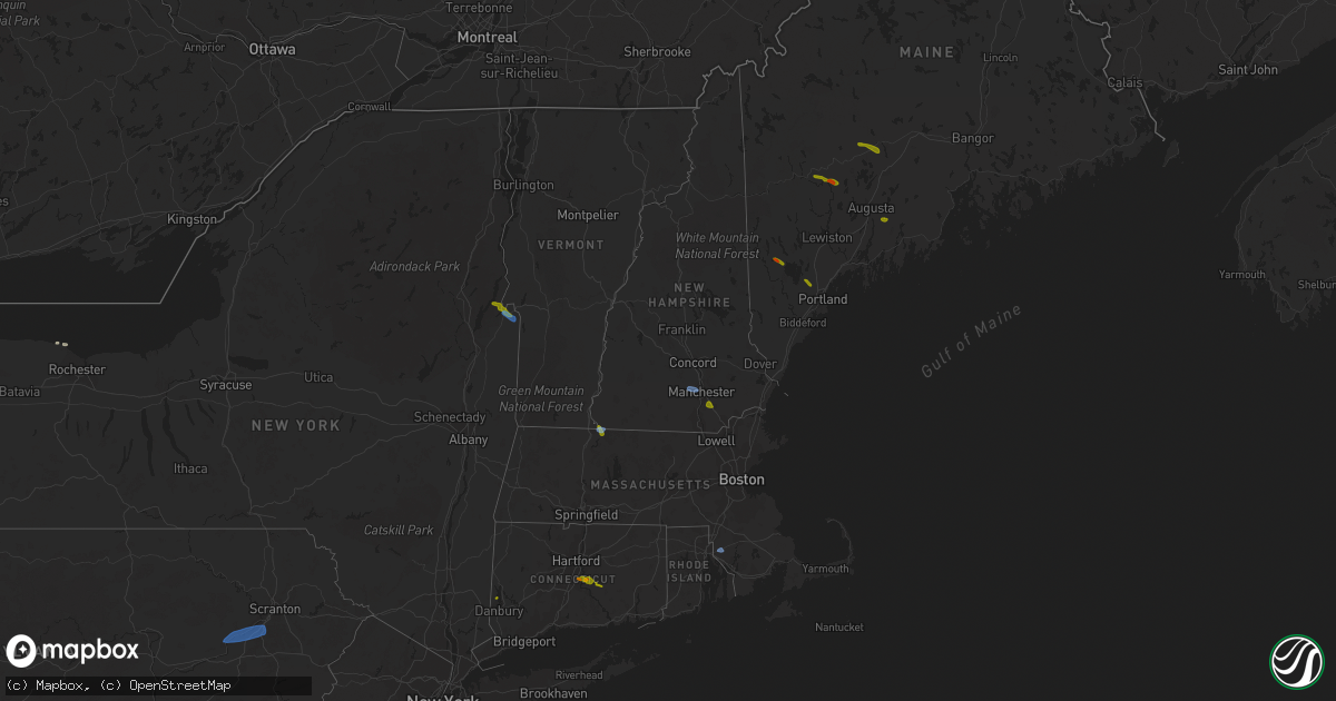
Hail Map in New Hampshire on August 24, 2020
Get this storm
August 24 map
$229
one time, instant access
Download today. No call, no setup
Keep the $229
Bought the map and want the full workflow? Apply the entire $229 to a subscription within 7 days. None of it is wasted.
Every map, not just this one
This buys you this map. Subscription and you get every map we run, in the markets you choose from a few cities to whole states to nationwide. Plus real-time alerts the moment a storm fires.
Contact data
Name, contact info, occupancy, even credit band for addresses in the footprint. You go from where it hit to who to call.
Become the source they trust
Unlimited branding weather history reports on demand. You already have the documented answer ready for the property owner, and you are the one who showed up with it.
Property data and RoofTrace estimates
Pull up any address you have got, its value and the exact code rules for that jurisdiction, straight from One Click Code. Then RoofTrace estimates the squares, pitch, and roof value, priced the way you price.
Storm reports in New Hampshire
New Hampshire
| Date | Description |
|---|---|
| 08/24/20203:18 PM CDT | A local report indicates 1.00 inch wind near DERRY |
| 08/24/20203:10 PM CDT | A local report indicates 1.25 inch wind near 1 NW DERRY |
| 08/24/20203:04 PM CDT | A local report indicates 1.25 inch wind near 3 S AUBURN |
| 08/24/20203:00 PM CDT | A local report indicates 1.00 inch wind near 2 N HUDSON |
| 08/24/20203:00 PM CDT | Trees down. |
| 08/24/20202:40 PM CDT | Trees down. |
| 08/24/20201:50 PM CDT | Trees down at burt hill rd. |
| 08/24/20201:29 AM CDT | At 629 PM EDT, a severe thunderstorm was located near Hooksett, or near Concord, moving east at 20 mph. HAZARD...60 mph wind gusts and quarter size hail. SOURCE...Radar indicated. IMPACT...Hail damage to vehicles is expected. Expect wind damage to roofs, siding, and trees. Locations impacted include... Concord, Hooksett, Hopkinton, Epsom, Bow, Allenstown, Deerfield, Candia, Dunbarton, Chichester and Pembroke.This includes the following highways... Interstate 293 near mile marker 11. Interstate 89 between mile markers 0 and 6. Interstate 93 between mile markers 25 and 39. |
All States Impacted by Hail Map on August 24, 2020
Cities Impacted by Hail Map on August 24, 2020
- Greenwood, WI
- Stoughton, WI
- Janesville, WI
- Edgerton, WI
- Sharon, WI
- Milton, WI
- Darien, WI
- Avalon, WI
- Cambridge, WI
- Clinton, WI
- Fort Atkinson, WI
- Augusta, WI
- Osseo, WI
- Fairchild, WI
- Markesan, WI
- Cambria, WI
- Fox Lake, WI
- Randolph, WI
- Columbus, WI
- Sun Prairie, WI
- Marshall, WI
- Deforest, WI
- Arlington, WI
- Rio, WI
- Poynette, WI
- Spencer, WI
- Chili, WI
- Pittsville, WI
- Necedah, WI
- Nekoosa, WI
- Arkdale, WI
- Willard, WI
- Franklin, MN
- Fairfax, MN
- Westfield, WI
- Oxford, WI
- Gibbon, MN
- Hector, MN
- Grand Marsh, WI
- Wisconsin Dells, WI
- Delavan, WI
- Butler, WI
- Brookfield, WI
- Milwaukee, WI
- Walworth, WI
- Burlington, WI
- Springfield, WI
- Lake Geneva, WI
- Elkhorn, WI
- Whitewater, WI
- Palmyra, WI
- Westfield, NY
- Eau Claire, WI
- Wisconsin Rapids, WI
- Stanley, WI
- Alma Center, WI
- Wautoma, WI
- Neshkoro, WI
- Lake Mills, WI
- Waterloo, WI
- Neillsville, WI
- Deerfield, WI
- Stratford, WI
- Waupun, WI
- Beaver Dam, WI
- Friendship, WI
- Coloma, WI
- Chippewa Falls, WI
- Elk Mound, WI
- Colfax, WI
- Olivia, MN
- Bird Island, MN
- Hebron, IL
- Woodstock, IL
- Wonder Lake, IL
- Babcock, WI
- Ripley, NY
- North East, PA
- Iron Ridge, WI
- Hartford, WI
- Rubicon, WI
- Horicon, WI
- Lodi, WI
- Dane, WI
- Adams, WI
- Montello, WI
- Marshfield, WI
- Auburndale, WI
- Hubertus, WI
- Colgate, WI
- Fall River, WI
- Pardeeville, WI
- Portage, WI
- Granton, WI
- Mosinee, WI
- Endeavor, WI
- Packwaukee, WI
- Hancock, WI
- Watertown, WI
- Dalton, WI
- Bancroft, WI
- Mchenry, IL
- Crystal Lake, IL
- Wyocena, WI
- Burnett, WI
- Harvard, IL
- Humbird, WI
- Fall Creek, WI
- Merrillan, WI
- Madison, WI
- Berlin, WI
- Hilton, NY
- Jefferson, WI
- Loyal, WI
- Cadott, WI
- Vesper, WI
- Arpin, WI
- Buffalo Lake, MN
- Lowell, WI
- Hustisford, WI
- Eleva, WI
- Neosho, WI
- Black River Falls, WI
- Port Edwards, WI
- Williams Bay, WI
- Lake In The Hills, IL
- Algonquin, IL
- Cottage Grove, WI
- Sussex, WI
- Barrington, IL
- Cary, IL
- Fox River Grove, IL
- Hoffman Estates, IL
- Richmond, IL
- Reeseville, WI
- Richfield, WI
- Fontana, WI
- Strum, WI
- Juneau, WI
- Palatine, IL
- Doylestown, WI
- Ringwood, IL
- Kingston, WI
- Brandon, WI
- New Lisbon, WI
- Tomah, WI
- Theresa, WI
- Allenton, WI
- Mayville, WI
- Owen, WI
- Brownsville, WI
- Lomira, WI
- Fond Du Lac, WI
- Oakfield, WI
- Menomonee Falls, WI
- West Bend, WI
- Lebanon, WI
- Ripon, WI
- Hewitt, WI
- Princeton, WI
- Carpentersville, IL
- Londonderry, NH
- Derry, NH
- Northfield, MA
- Winchester, NH
- Vernon, VT
- Hinsdale, NH
- East Hampton, CT
- Colchester, CT
- Portland, CT
- Cromwell, CT
- South Glastonbury, CT
- New Fairfield, CT
- Starksboro, VT
- Whitehall, NY
- Fair Haven, VT
- Huletts Landing, NY
- Clemons, NY
- Goffstown, NH
- Manchester, NH
- Rehoboth, MA
- Kents Hill, ME
- Canton, ME
- Livermore Falls, ME
- Jay, ME
- Skowhegan, ME
- Anson, ME
- Norridgewock, ME
- Naples, ME
- Sebago, ME
- Gardiner, ME
- Whitefield, ME
- Windham, ME
- Bristol, VT
- Poultney, VT
- Fredericksburg, VA
- Shickshinny, PA
- Plymouth, PA
- Wilkes Barre, PA
- Nanticoke, PA
- Wapwallopen, PA
- Hunlock Creek, PA
- Glen Lyon, PA
- Kingston, PA
- Mountain Top, PA
- Altoona, WI


