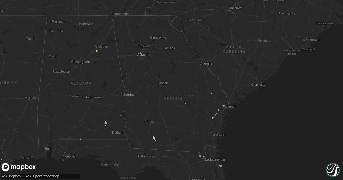
Hail Map in Georgia on August 21, 2025
Get this storm
August 21 map
$229
one time, instant access
Download today. No call, no setup
Keep the $229
Bought the map and want the full workflow? Apply the entire $229 to a subscription within 7 days. None of it is wasted.
Every map, not just this one
This buys you this map. Subscription and you get every map we run, in the markets you choose from a few cities to whole states to nationwide. Plus real-time alerts the moment a storm fires.
Contact data
Name, contact info, occupancy, even credit band for addresses in the footprint. You go from where it hit to who to call.
Become the source they trust
Unlimited branding weather history reports on demand. You already have the documented answer ready for the property owner, and you are the one who showed up with it.
Property data and RoofTrace estimates
Pull up any address you have got, its value and the exact code rules for that jurisdiction, straight from One Click Code. Then RoofTrace estimates the squares, pitch, and roof value, priced the way you price.
Storm reports in Georgia
Georgia
| Date | Description |
|---|---|
| 08/21/20256:39 PM CDT | Mping report: tree limbs and tree uprooted near ga 202. |
| 08/21/20256:30 PM CDT | Corrects previous tstm wnd dmg report from 2 w chastain. Mping report: tree limbs and tree uprooted near ga 202. Time adjusted after confirmation from trained spotter. |
| 08/21/20255:49 PM CDT | Emergency manager reported several trees down east southeast of ludowici along old macon darien road... Hill street... Prince road and stafford dairy road. A few trees |
| 08/21/20255:15 PM CDT | Corrects previous t |
| 08/21/20255:15 PM CDT | Corrects previous tstm wnd dmg report from little five points. Large tree limbs downed near the intersection of moreland ave and austin ave due to thunderstorm winds. |
| 08/21/20254:58 PM CDT | A photo on social media shows a large tree limb blown down near the hamilton e. Holmes marta station. |
All States Impacted by Hail Map on August 21, 2025
Cities Impacted by Hail Map on August 21, 2025
- Salol, MN
- Roseau, MN
- Warroad, MN
- Pompano Beach, FL
- Belle Glade, FL
- Georgetown, TX
- Ponchatoula, LA
- Reagan, TX
- Kosse, TX
- Ashville, AL
- Gadsden, AL
- Jewett, TX
- Flomaton, AL
- Rainbow City, AL
- Bremond, TX
- Marlin, TX
- Wing, AL
- Calvert, TX
- Saint George, GA
- Franklin, TX
- Rosebud, TX
- Slidell, LA
- Glen Saint Mary, FL
- Sanderson, FL
- Geismar, LA
- Darrow, LA
- Gonzales, LA
- Prairieville, LA
- Cameron, TX
- Buckholts, TX
- Statesboro, GA
- Davilla, TX
- Waco, TX
- Brundidge, AL
- Ariton, AL
- Enterprise, AL
- Three Rivers, TX
- Fellsmere, FL
- Milano, TX
- Jack, AL
- Vero Beach, FL
- Donaldsonville, LA
- New Brockton, AL
- Ponte Vedra, FL
- Eufaula, AL
- Ponte Vedra Beach, FL
- Lake City, FL
- Melbourne, FL
- Elm Mott, TX
- Indialantic, FL
- Henderson, TX
- Carthage, TX
- Mount Enterprise, TX
- Long Branch, TX
- Rockledge, FL
- Orlando, FL
- Merritt Island, FL
- Atlanta, GA
- Sinton, TX
- Clifton, AZ
- Alice, TX
- Pontotoc, TX
- Mason, TX
- Blakely, GA
- Pooler, GA
- Bloomingdale, GA
- Mableton, GA
- Laneville, TX
- Savannah, GA
- Robstown, TX
- Art, TX
- Fort Stewart, GA
- Needville, TX
- Damon, TX
- Hinesville, GA
- Palacios, TX
- Bay City, TX
- Reklaw, TX
- Ludowici, GA
- Fairmount, ND
- Pitkin, LA
- Rosholt, SD
- Wheaton, MN
- Rosharon, TX
- Allenhurst, GA
- Mittie, LA
- Alamo, GA
- Hankinson, ND
- Jesup, GA
- Thomasville, GA
- Coolidge, GA
- Tintah, MN
- Pinehurst, TX
- Magnolia, TX
- Dumont, MN
- Ochlocknee, GA
- Wahpeton, ND
- Sugar Land, TX
- Richmond, TX
- Beardsley, MN
- Mitchell, NE
- Meigs, GA
- Hockley, TX
- Houston, TX
- Barry, MN
- Graceville, MN
- Ten Sleep, WY
- Kaycee, WY
- Clinton, MN
- Ortonville, MN
- Chokio, MN
- Corona, SD
- Sulphur, LA
- Big Stone City, SD
- Correll, MN
- Peever, SD
- Viking, MN
- Warren, MN
- Crown King, AZ
- Wilmot, SD
- Fort Mcdowell, AZ
- Odessa, MN
- Thief River Falls, MN
- Appleton, MN
- Roma, TX
- Twin Brooks, SD
- Milbank, SD
- South Shore, SD
- Rio Grande City, TX
- Bellingham, MN
- Holloway, MN
- Clark, SD
- Madison, MN
- Argyle, MN
- Stockholm, SD
- Willow Lake, SD
- Huron, SD
- Strandburg, SD
- Watertown, SD
- Yale, SD
- Superior, AZ
- Goodwin, SD
- Hitchcock, SD
- Iroquois, SD
- Carpenter, SD
- Phoenix, AZ
- Tempe, AZ
- Doland, SD
- Canby, MN
- Hardin, MT
- Cavour, SD
- Miller, SD
- Ree Heights, SD
- Forsyth, MT
- Carthage, SD
- De Smet, SD
- Saint Lawrence, SD
- Redfield, SD
- Rockham, SD
- Howard, SD
- Tulare, SD
- Canova, SD
- Winfred, SD
- Salem, SD
- Wessington, SD
- Kadoka, SD
- Wolsey, SD
- Milesville, SD
- Montrose, SD
- Artesian, SD
- Fedora, SD
- Fort Pierre, SD
- Pierre, SD
- Presho, SD
- Blunt, SD
- Lower Brule, SD
- Harrold, SD
- Spencer, SD
- Kennebec, SD


