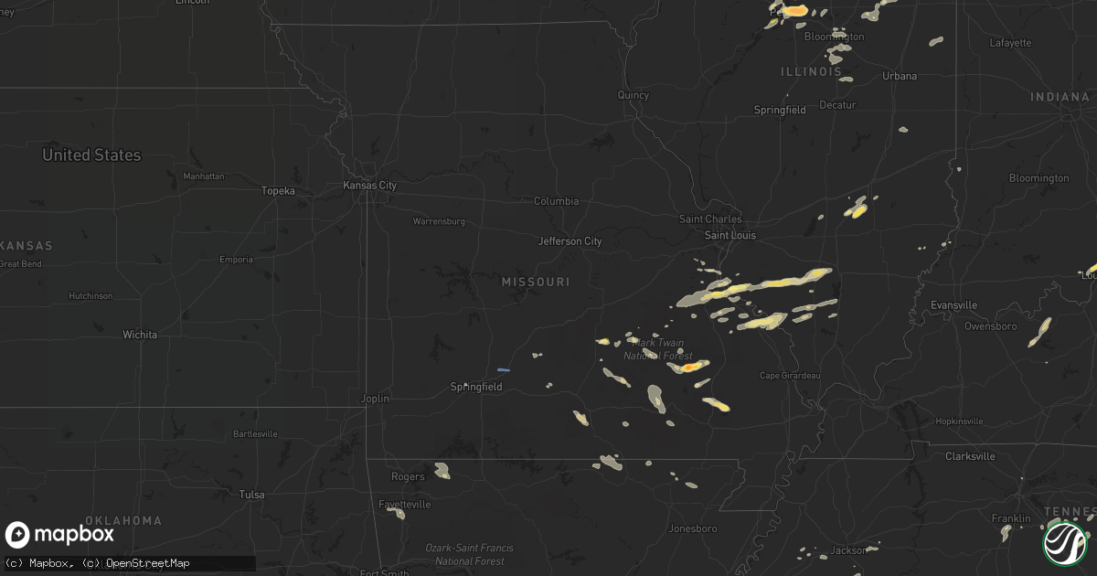
Hail Map in Missouri on August 20, 2022
Get this storm
August 20 map
$229
one time, instant access
Download today. No call, no setup
Keep the $229
Bought the map and want the full workflow? Apply the entire $229 to a subscription within 7 days. None of it is wasted.
Every map, not just this one
This buys you this map. Subscription and you get every map we run, in the markets you choose from a few cities to whole states to nationwide. Plus real-time alerts the moment a storm fires.
Contact data
Name, contact info, occupancy, even credit band for addresses in the footprint. You go from where it hit to who to call.
Become the source they trust
Unlimited branding weather history reports on demand. You already have the documented answer ready for the property owner, and you are the one who showed up with it.
Property data and RoofTrace estimates
Pull up any address you have got, its value and the exact code rules for that jurisdiction, straight from One Click Code. Then RoofTrace estimates the squares, pitch, and roof value, priced the way you price.
Storm reports in Missouri
Missouri
| Date | Description |
|---|---|
| 08/20/20224:01 PM CDT | A local report indicates 1.00 inch wind near 5 W SALEM |
| 08/20/20221:40 PM CDT | Report of a tree that fell onto a powerline on highway a near chrisco cemetery. Time estimated from radar. |
| 08/20/20221:40 PM CDT | A large tree was reported down on highway 19 blocking the road. |
| 08/20/20226:02 AM CDT | At 1101 PM CDT, a severe thunderstorm was located near Bloomsdale, moving east at 40 mph. HAZARD...60 mph wind gusts and quarter size hail. SOURCE...Radar indicated. IMPACT...Hail damage to vehicles is expected. Expect wind damage to roofs, siding, and trees. This severe thunderstorm will be near... Red Bud around 1115 PM CDT. Evansville around 1120 PM CDT. Baldwin around 1130 PM CDT. Sparta around 1140 PM CDT. Coulterville and Tilden around 1145 PM CDT.Other locations impacted by this severe thunderstorm include Ruma,Walsh, Renault, Preston, Ames, Modoc, Prairie, Eden, Prairie DuRocher and Kidd. |
| 08/20/20225:39 AM CDT | At 1038 PM CDT, a severe thunderstorm was located near Valles Mill, moving east at 30 mph. HAZARD...60 mph wind gusts and quarter size hail. SOURCE...Radar indicated. IMPACT...Hail damage to vehicles is expected. Expect wind damage to roofs, siding, and trees. Locations impacted include... Olympian Village, Bloomsdale and Valles Mill. This includes Interstate 55 in Missouri near exit 162. |
| 08/20/20224:59 AM CDT | At 959 PM CDT, a severe thunderstorm was located 8 miles south of Willow Springs, moving southeast at 30 mph. HAZARD...60 mph wind gusts and penny size hail. SOURCE...Radar indicated. IMPACT...Expect damage to roofs, siding, and trees. This severe thunderstorm will be near... West Plains around 1020 PM CDT.Other locations impacted by this severe thunderstorm include Pomonaand White Church. |
| 08/20/20224:15 AM CDT | At 915 PM CDT, a severe thunderstorm was located over Annapolis, moving northeast at 30 mph. HAZARD...60 mph wind gusts and quarter size hail. SOURCE...Radar indicated. IMPACT...Hail damage to vehicles is expected. Expect wind damage to roofs, siding, and trees. Locations impacted include... Annapolis, Sabula and Chloride. |
| 08/20/20223:53 AM CDT | At 853 PM CDT, a severe thunderstorm was located 9 miles east of Salem, moving east at 35 mph. HAZARD...60 mph wind gusts and quarter size hail. SOURCE...Radar indicated. IMPACT...Hail damage to vehicles is expected. Expect wind damage to roofs, siding, and trees. Locations impacted include... Howes Mill... Stone Hill... Boss... |
| 08/20/20223:15 AM CDT | At 815 PM CDT, a severe thunderstorm was located near Eminence, or 20 miles northeast of Mountain View, moving southeast at 10 mph. HAZARD...60 mph wind gusts and nickel size hail. SOURCE...Radar indicated. IMPACT...Expect damage to roofs, siding, and trees. Locations impacted include... Ozark National Scenic Riverways... Eminence... West Eminence... Alley Spring... |
| 08/20/20223:04 AM CDT | At 804 PM CDT, a severe thunderstorm was located 11 miles north of Hartville, or 19 miles southeast of Lebanon, moving east at 25 mph. HAZARD...60 mph wind gusts and penny size hail. SOURCE...Radar indicated. IMPACT...Expect damage to roofs, siding, and trees. Locations impacted include... Plato... Competition... Manes... Lynchburg... |
| 08/20/20222:42 AM CDT | At 742 PM CDT, a severe thunderstorm was located 9 miles northeast of Summersville, or 20 miles northeast of Mountain View, moving east at 15 mph. HAZARD...60 mph wind gusts and nickel size hail. SOURCE...Radar indicated. IMPACT...Expect damage to roofs, siding, and trees. Locations impacted include... Echo Bluff State Park... Current River State Park... Ozark National Scenic Riverways... Eminence... Alley Spring... Round Spring... West Eminence... |
| 08/20/20222:20 AM CDT | At 720 PM CDT, a severe thunderstorm was located near Marshfield, moving east at 20 mph. HAZARD...60 mph wind gusts. SOURCE...Radar indicated. IMPACT...Expect damage to roofs, siding, and trees. Locations impacted include... Marshfield... Niangua... This includes Interstate 44 between mile markers 93 and 105. |
| 08/20/20222:01 AM CDT | At 701 PM CDT, a severe thunderstorm was located 7 miles east of Raymondville, or 14 miles east of Houston, moving east at 15 mph. HAZARD...60 mph wind gusts and quarter size hail. SOURCE...Radar indicated. IMPACT...Hail damage to vehicles is expected. Expect wind damage to roofs, siding, and trees. Locations impacted include... Current River State Park... Ozark National Scenic Riverways... Round Spring... Akers... Hartshorn... |
| 08/20/202212:12 AM CDT | At 512 PM CDT, a severe thunderstorm was located near Shook, or near Lake Wappapello State Park, moving east at 25 mph. HAZARD...60 mph wind gusts and quarter size hail. SOURCE...Radar indicated. IMPACT...Hail damage to vehicles is expected. Expect wind damage to roofs, siding, and trees. This severe thunderstorm will be near... Puxico around 530 PM CDT. |
| 08/19/202211:43 PM CDT | At 442 PM CDT, a severe thunderstorm was located near Greenville, moving east at 25 mph. HAZARD...60 mph wind gusts and quarter size hail. SOURCE...Radar indicated. IMPACT...Hail damage to vehicles is expected. Expect wind damage to roofs, siding, and trees. Locations impacted include... Shook. |
| 08/19/202210:47 PM CDT | Verified with photo. |
| 08/19/202210:30 PM CDT | At 330 PM CDT, a severe thunderstorm was located 9 miles northeast of Licking, or 13 miles west of Salem, moving east at 25 mph. HAZARD...60 mph wind gusts and penny size hail. SOURCE...Radar indicated. IMPACT...Expect damage to roofs, siding, and trees. Locations impacted include... Salem... Lenox... Turtle... Boss... Howes... Howes Mill... Darien... Stone Hill... Sligo... Anutt... |
| 08/19/20229:19 PM CDT | Hail up to golfball size... Though most were one inch in diameter. |
| 08/19/20228:17 PM CDT | At 116 PM CDT, a severe thunderstorm was located 14 miles northeast of Summersville, or near Akers, moving southeast at 20 mph. HAZARD...60 mph wind gusts and penny size hail. SOURCE...Radar indicated. IMPACT...Expect damage to roofs, siding, and trees. Locations impacted include... Echo Bluff State Park... Current River State Park... Ozark National Scenic Riverways... Round Spring... Akers... Midridge... |
| 08/19/20227:53 PM CDT | Report of wind damage to an outbuilding in grovespring. Ti |
| 08/19/20227:53 PM CDT | Report of wind damage to an outbu |
| 08/19/20227:53 PM CDT | Report of wind damage to an outbuilding in grovespring. Time estimated from radar. |
| 08/19/20227:24 PM CDT | Report of a tree through the roof of a home on north pine street. Time estimated from radar. |
| 08/19/20227:24 PM CDT | Report of a tree through the roof of a home on north pine |
| 08/19/20227:10 PM CDT | Eight inch limb down. Reported by off duty nws employee. |
| 08/19/20227:07 PM CDT | Sgf asos measured a 51 knot peak wind gust. |
All States Impacted by Hail Map on August 20, 2022
Cities Impacted by Hail Map on August 20, 2022
- Goshen, OH
- Florence, IN
- Vevay, IN
- Earlville, NY
- Smyrna, NY
- Clyde, OH
- Fremont, OH
- Yorkshire, OH
- Metamora, IL
- Mount Carmel, IL
- West Salem, IL
- Centerburg, OH
- Croton, OH
- Belgrade, MO
- Potosi, MO
- Marlette, MI
- Kingston, MI
- Snover, MI
- Towanda, IL
- Normal, IL
- Sainte Genevieve, MO
- Kingston, OH
- South Bloomingville, OH
- Laurelville, OH
- Salem, MO
- Norwood, MO
- Cygnet, OH
- Bloomdale, OH
- North Baltimore, OH
- Augusta, KY
- Germantown, KY
- Maynard, AR
- Pocahontas, AR
- Cardington, OH
- Marengo, OH
- Fulton, OH
- Mount Gilead, OH
- Fredericktown, OH
- Chesterville, OH
- Bellville, OH
- Auburntown, TN
- Woodbury, TN
- Rockvale, TN
- Murfreesboro, TN
- Convoy, OH
- Monroeville, IN
- Land O'Lakes, FL
- Lutz, FL
- Odessa, FL
- Mountain Grove, MO
- Hartville, MO
- Hillsboro, OH
- Boonville, NY
- Hawthorne, FL
- Orient, OH
- Ashville, OH
- Mount Sterling, OH
- Milton, TN
- Brownsville, TN
- Patterson, MO
- Lithia, FL
- Prairie Du Rocher, IL
- Edwards, IL
- Hanna City, IL
- Peoria, IL
- Bonne Terre, MO
- Harrod, OH
- Forrest, IL
- Chatsworth, IL
- Congress, AZ
- Wittmann, AZ
- Ransom, IL
- Streator, IL
- Tuskegee, AL
- Union Springs, AL
- Luverne, AL
- Russia, OH
- Versailles, OH
- Littlefield, AZ
- Verona, IL
- Kinsman, IL
- Dunlap, IL
- McNabb, IL
- Varna, IL
- Hennepin, IL
- Magnolia, IL
- Putnam, IL
- Lacon, IL
- Chillicothe, IL
- Henry, IL
- Washburn, IL
- Edelstein, IL
- Sparland, IL
- McLean, IL
- Marion, OH
- Pleasant Plain, OH
- Cable, OH
- North Lewisburg, OH
- Mechanicsburg, OH
- Woodstock, OH
- Mount Orab, OH
- Blanchester, OH
- New Vienna, OH
- Martinsville, OH
- Lynchburg, OH
- Williamsburg, OH
- Fayetteville, OH
- Midland, OH
- Defiance, OH
- Dunkirk, IN
- Albany, IN
- Redkey, IN
- Rankin, IL
- Rossville, IL
- Hoopeston, IL
- Grove City, OH
- Columbus, OH
- Speer, IL
- Bradford, IL
- Paragonah, UT
- Grovespring, MO
- Lebanon, MO
- Mineral Point, MO
- Irondale, MO
- Bolivar, NY
- Little Genesee, NY
- Seaman, OH
- Sardinia, OH
- Winchester, OH
- Craigville, IN
- Bluffton, IN
- Decatur, IN
- Waynesville, IL
- Heyworth, IL
- Downs, IL
- Le Roy, IL
- Shirley, IL
- Wapella, IL
- Bloomington, IL
- Vanzant, MO
- Pomona, MO
- Willow Springs, MO
- Richfield, UT
- New Paris, OH
- Dalton, GA
- Chatsworth, GA
- Congerville, IL
- Eureka, IL
- Charleston, IL
- Arcadia, MO
- Vulcan, MO
- Centerville, MO
- Ellington, MO
- Lesterville, MO
- Redford, MO
- Annapolis, MO
- Elkville, IL
- Ava, IL
- De Soto, IL
- Vergennes, IL
- Murphysboro, IL
- Peebles, OH
- Lodi, MO
- Colorado City, AZ
- Farmington, MO
- Hillsboro, MO
- Oakdale, IL
- Woodlawn, IL
- Tamaroa, IL
- Du Bois, IL
- Pinckneyville, IL
- Baldwin, IL
- Coulterville, IL
- Nashville, IL
- Ashley, IL
- Sparta, IL
- Decker, MI
- Cass City, MI
- Deford, MI
- London, OH
- Charleston, WV
- Poca, WV
- Kenna, WV
- Bloomsdale, MO
- Georgetown, IN
- Corydon, IN
- Colfax, IL
- Chenoa, IL
- Cropsey, IL
- Fairbury, IL
- Patoka, IL
- Vandalia, IL
- Vernon, IL
- Leesburg, OH
- Phelps, NY
- Standish, MI
- Maybee, MI
- Monroe, MI
- Glasford, IL
- Manito, IL
- Mapleton, IL
- Kingston Mines, IL
- Springfield, OH
- Modoc, IL
- Surprise, AZ
- Red Bud, IL
- Blackwell, MO
- Cadet, MO
- French Village, MO
- Valles Mines, MO
- Evansville, IL
- Festus, MO
- Fults, IL
- Valmeyer, IL
- De Soto, MO
- Mount Vernon, IL
- Waltonville, IL
- Gordon, WV
- Bob White, WV
- Van, WV
- Twilight, WV
- Madison, WV
- Claypool, IN
- Pierceton, IN
- Silver Lake, IN
- Port Allegany, PA
- Turtlepoint, PA
- Scott, OH
- Van Wert, OH
- Galion, OH
- Longmont, CO
- Mead, CO
- Logan, OH
- Calamus, IA
- Wheatland, IA
- Dixon, IA
- New Liberty, IA
- Williamsport, OH
- Circleville, OH
- Morton, IL
- Deer Creek, IL
- Tremont, IL
- Mackinaw, IL
- Creve Coeur, IL
- Peoria Heights, IL
- East Peoria, IL
- Washington, IL
- El Paso, IL
- Secor, IL
- Wapakoneta, OH
- Lima, OH
- Boss, MO
- Bixby, MO
- Thurston, OH
- Millersport, OH
- Baltimore, OH
- Lancaster, OH
- Pleasantville, OH
- Sidney, OH
- Quincy, OH
- Pekin, IL
- Van Buren, MO
- Bennett, IA
- McGuffey, OH
- Alger, OH
- Ada, OH
- Georgetown, OH
- Lachine, MI
- Hanksville, UT
- Dowell, IL
- Benton, IL
- Christopher, IL
- Mulkeytown, IL
- Buckner, IL
- Du Quoin, IL
- Malinta, OH
- Deshler, OH
- Hamler, OH
- Roseville, OH
- New Bavaria, OH
- Napoleon, OH
- Continental, OH
- Holgate, OH
- Oakwood, OH
- Grand Ridge, IL
- Ottawa, IL
- Marseilles, IL
- Armada, MI
- Ava, NY
- Lee Center, NY
- House Springs, MO
- Cambridge, OH
- Dieterich, IL
- Saint Elmo, IL
- Eminence, MO
- Hartshorn, MO
- Raymondville, MO
- Grand Marais, MI
- Farmersburg, IN
- Licking, MO
- Thomaston, GA
- Thompsons Station, TN
- Franklin, TN
- Lenox, MO
- Lascassas, TN
- Gainesville, FL
- Brooker, FL
- Meadview, AZ
- Fort Payne, AL
- Valley Head, AL
- Mentone, AL
- Bradyville, TN
- Windermere, FL
- Winter Garden, FL
- Orlando, FL
- Hopewell, OH
- Mount Perry, OH
- Zanesville, OH
- Heath, OH
- Somerset, OH
- Glennville, GA
- Frazeysburg, OH
- Dresden, OH
- Nashport, OH
- Kingman, AZ
- Saint Mary, MO
- Campbell Hill, IL
- Chester, IL
- Perryville, MO
- Rockwood, IL
- Wappapello, MO
- Greenville, MO
- Williamsville, MO
- Bedford, KY
- Morrison, TN
- Koshkonong, MO
- Mammoth Spring, AR
- Salem, AR
- Camp, AR
- Thayer, MO
- West Plains, MO
- Fitzpatrick, AL
- Pevely, MO
- Barnhart, MO
- Saint Peter, IL
- Berryville, AR
- Eureka Springs, AR
- Iowa Park, TX
- Quanah, TX
- Welch, TX
- Clarksville, IN
- New Albany, IN
- Sellersburg, IN
- Floyds Knobs, IN
- Charlestown, IN
- Jeffersonville, IN
- West Fork, AR
- Fayetteville, AR
- Farina, IL
- Fordsville, KY
- Hardinsburg, KY
- Falls Of Rough, KY
- Harned, KY
- Saint Petersburg, FL
- Aguila, AZ
- Wickenburg, AZ
- Lake Park, GA
- Valdosta, GA
- Bunker, MO
- Herculaneum, MO
- Ocala, FL
- Odum, GA
- Pinson, TN
- Ray City, GA
- Hahira, GA
- Henderson, TN
- Hornsby, TN
- Piper City, IL
- Williamsville, IL
- Kimbolton, OH
- Milton, KY
- Edgewood, IL
- Springfield, MO
- Dowelltown, TN
- Smithville, TN
- Liberty, TN
- Kinmundy, IL
- Herrin, IL
- West Frankfort, IL
- Edgar Springs, MO
- Peach Orchard, AR
- Delaplaine, AR
- Paragould, AR
- Conifer, CO
- Birch Tree, MO
- Vincennes, IN
- Columbia, TN
- Spring Hill, TN
- Seligman, AZ
- Sturkie, AR
- Beechgrove, TN
- Mcminnville, TN
- Manchester, TN
- Columbia, AL
- Abbeville, AL
- Waterloo, IL
- Fredericktown, MO
- Frohna, MO
- Liberty, IN
- West College Corner, IN
- Bristol, FL
- Saint George, UT
- Winona, MO
- Fremont, MO
- Allendale, IL
- Auburn, AL
- Waverly, AL
- Alachua, FL
- Beech Bluff, TN
- Huron, TN
- Lexington, TN
- Maroa, IL
- Clinton, IL
- Weldon, IL
- South Vienna, OH
- Stoutsville, OH
- Floral City, FL
- Macon, MS
- Sulligent, AL
- Detroit, AL
- Prairie Grove, AR
- Farmington, AR
- Chiefland, FL
- Bronson, FL
- Lanesville, IN
- New Lexington, OH
- Batavia, OH
- Owensville, OH
- Mason, IL
- Nabb, IN
- Marysville, IN
- Bethlehem, IN
- New Washington, IN
- Carrollton, KY
- Caneyville, KY
- Mill Spring, MO
- Colcord, OK
- Bagdad, AZ
- Lake Butler, FL
- College Grove, TN
- Folkston, GA
- Reform, AL
- Fargo, GA
- Lake City, FL
- Cisco, GA
- Washington Court House, OH
- Bolivar, TN
- Finger, TN
- Seagrove, NC
- Brownfield, TX
- Morrison, CO
- Goodlettsville, TN
- Warsaw, OH
- Fresno, OH
- Coshocton, OH
- Galena, OH
- Lovington, NM
- Gordo, AL
- Menlo, GA
- Summerville, GA
- Littleton, CO
- Cadiz, OH
- Hopedale, OH
- Freeport, OH
- Quaker City, OH
- Piedmont, OH
- Kipling, OH
- Flushing, OH
- Saint Clairsville, OH
- Lore City, OH
- Barnesville, OH
- Salesville, OH
- Jewett, OH
- Cumberland, OH
- Byesville, OH
- Old Washington, OH
- New Concord, OH
- Marshfield, MO


