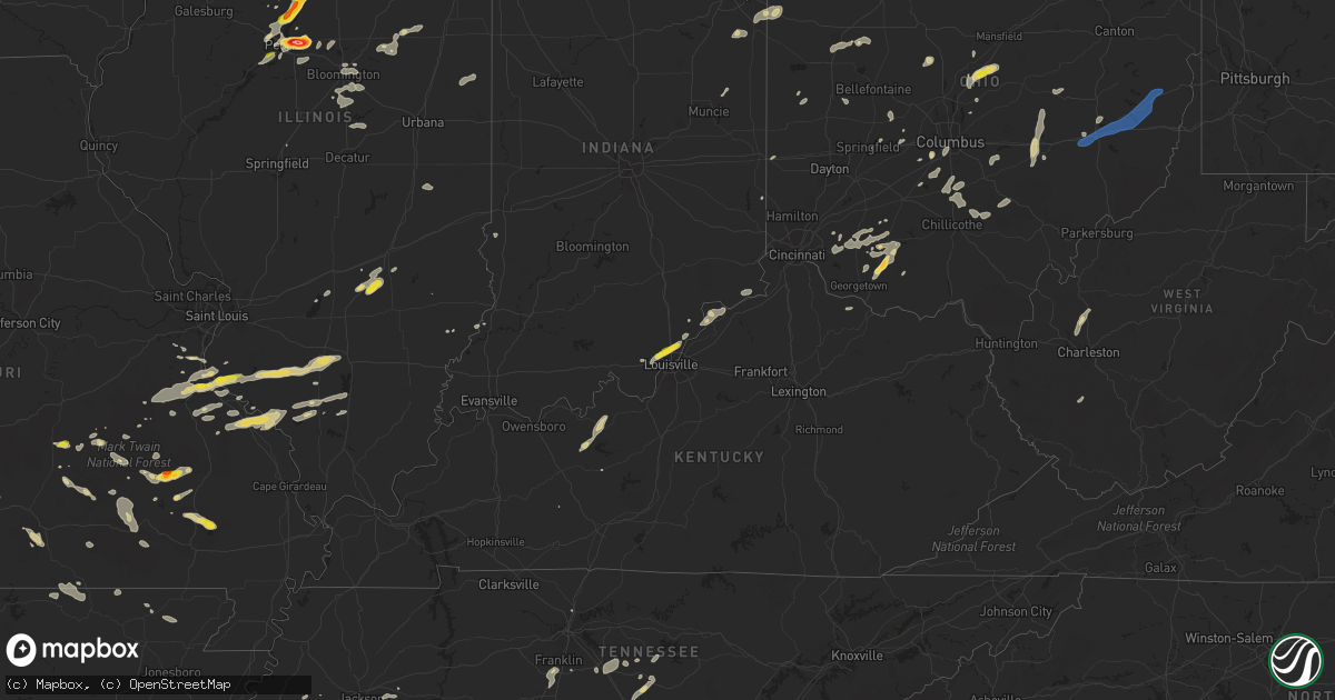
Hail Map on August 20, 2022
Get this storm
August 20 map
$229
one time, instant access
Download today. No call, no setup
Keep the $229
Bought the map and want the full workflow? Apply the entire $229 to a subscription within 7 days. None of it is wasted.
Every map, not just this one
This buys you this map. Subscription and you get every map we run, in the markets you choose from a few cities to whole states to nationwide. Plus real-time alerts the moment a storm fires.
Contact data
Name, contact info, occupancy, even credit band for addresses in the footprint. You go from where it hit to who to call.
Become the source they trust
Unlimited branding weather history reports on demand. You already have the documented answer ready for the property owner, and you are the one who showed up with it.
Property data and RoofTrace estimates
Pull up any address you have got, its value and the exact code rules for that jurisdiction, straight from One Click Code. Then RoofTrace estimates the squares, pitch, and roof value, priced the way you price.
States Impacted by Hail Map on August 20, 2022
Storm reports
West Virginia
| Date | Description |
|---|---|
| 08/20/20224:26 AM CDT | At 926 PM EDT, severe thunderstorms were located along a line extending from 6 miles south of Dennison to near Barnesville to 11 miles northeast of Caldwell, moving east at 50 mph. HAZARD...60 mph wind gusts and quarter size hail. SOURCE...Radar indicated. IMPACT...Minor hail damage to vehicles is possible. Expect wind damage to trees and power lines, resulting in some power outages. Locations impacted include... Steubenville, Moundsville, Martins Ferry, St. Clairsville, Bellaire, Barnesville, Cadiz, Freeport, Wintersville, Shadyside, Powhatan Point, and Glen Dale. |
| 08/20/20223:30 AM CDT | Tree down at wv-39 and whitewater rd. Time estimated from radar. |
| 08/20/20223:27 AM CDT | Trees down along turnpike rd. Time estimated from radar. |
| 08/20/20223:03 AM CDT | Trees down along kentuck rd. |
Kentucky
| Date | Description |
|---|---|
| 08/20/20221:07 AM CDT | At 607 PM EDT, a severe thunderstorm was located near Bedford, moving northeast at 20 mph. HAZARD...60 mph wind gusts and quarter size hail. SOURCE...Radar indicated. IMPACT...Hail damage to vehicles is expected. Expect wind damage to roofs, siding, and trees. This severe thunderstorm will be near... Bedford around 625 PM EDT. |
| 08/20/202212:33 AM CDT | At 533 PM EDT, a severe thunderstorm was located near New Albany, moving northeast at 40 mph. HAZARD...60 mph wind gusts and half dollar size hail. SOURCE...Radar indicated. IMPACT...Hail damage to vehicles is expected. Expect wind damage to roofs, siding, and trees. This severe thunderstorm will remain over mainly rural areas of central Clark, northeastern Floyd and west central Oldham Counties, including the following locations... Speed, Saint Joseph, Sellersburg, Clark Siding, Prather, Harmony Village, Clark Regional Airport, Cementville, Floyds Knobs and Owen. |
Utah
| Date | Description |
|---|---|
| 08/19/202211:59 PM CDT | At 458 PM MDT, a severe thunderstorm was located 8 miles southeast of Hanksville, moving northeast at 15 mph. HAZARD...60 mph wind gusts and quarter size hail. SOURCE...Radar indicated. IMPACT...Hail damage to vehicles is expected. Expect wind damage to roofs, siding, and trees. This severe thunderstorm will remain over mainly rural areas of northeastern Garfield and eastern Wayne Counties.This includes Utah Route 95 between mile markers 3 and 17. |
| 08/19/202211:52 PM CDT | At 451 PM MDT, a severe thunderstorm was located 19 miles west of Green River, moving southeast at 10 mph. HAZARD...60 mph wind gusts and quarter size hail. SOURCE...Radar indicated. IMPACT...Hail damage to vehicles is expected. Expect wind damage to roofs, siding, and trees. Locations impacted include... Green River and Elgin. This includes the following highways... Interstate 70 between mile markers 142 and 163. US Route 6 between mile markers 289 and 300. Utah Route 24 between mile markers 157 and 160. |
| 08/19/20228:53 PM CDT | At 153 PM MDT, a severe thunderstorm was located 32 miles southwest of Milford, moving east at 5 mph. HAZARD...Half dollar size hail. SOURCE...Radar indicated. IMPACT...Damage to vehicles is expected. This severe thunderstorm will remain over mainly rural areas of south central Beaver and north central Iron Counties. |
California
| Date | Description |
|---|---|
| 08/19/202210:44 PM CDT | At 344 PM PDT, a severe thunderstorm was located 7 miles southeast of Joshua Tree, or 9 miles southwest of Twentynine Palms, moving southeast at 5 mph. HAZARD...60 mph wind gusts and quarter size hail. SOURCE...Radar indicated. IMPACT...Hail damage to vehicles is expected. Expect wind damage to roofs, siding, and trees. Locations impacted include... Lost Horse-Keys Village. |
| 08/19/202210:15 PM CDT | At 315 PM PDT, a severe thunderstorm was located over Joshua Tree Lake Campground, or 13 miles west of Twentynine Palms, moving northeast at 15 mph. HAZARD...60 mph wind gusts. SOURCE...Radar indicated. IMPACT...Expect damage to roofs and trees. Locations impacted include... Twentynine Palms, Twentynine Palms Base, Joshua Tree Lake Campground and Joshua Tree. |
Michigan
| Date | Description |
|---|---|
| 08/20/20224:16 AM CDT | At 916 PM EDT, a severe thunderstorm was located near Centreville, or near Three Rivers, moving north at 20 mph. HAZARD...60 mph wind gusts. SOURCE...Radar indicated. IMPACT...Expect damage to roofs, siding, and trees. This severe thunderstorm will be near... Three Rivers and Centreville around 925 PM EDT. |
Kansas
| Date | Description |
|---|---|
| 08/19/20229:36 PM CDT | At 236 AM CDT, a severe thunderstorm was located near Iola, moving east at 40 mph. HAZARD...60 mph wind gusts and quarter size hail. SOURCE...Radar indicated. IMPACT...Hail damage to vehicles is expected. Expect wind damage to roofs, siding, and trees. Locations impacted include... Iola, Humboldt, La Harpe, Gas, Moran, Savonburg, Elsmore, Bassett and Iola Airport. |
Tennessee
| Date | Description |
|---|---|
| 08/20/20224:08 PM CDT | Tree and power line down on highway 70 at dunn lane. |
| 08/20/20221:21 AM CDT | At 621 PM EDT, a severe thunderstorm was located over Sumac, or near Chatsworth, moving east at 15 mph. HAZARD...60 mph wind gusts and quarter size hail. SOURCE...Radar indicated. IMPACT...Hail damage to vehicles is expected. Expect wind damage to roofs, siding, and trees. Locations impacted include... Dalton, Chatsworth, Eton, Crandall, Sumac, Jones Mill, Gregory, Cohutta Wilderness, Conasauga Lake, Tennga, Beaverdale, Dawnville, Cisco and Colwell. |
| 08/19/202210:09 PM CDT | At 309 PM CDT, a severe thunderstorm was located near Walterhill, or near Murfreesboro, moving northeast at 20 mph. HAZARD...60 mph wind gusts and nickel size hail. SOURCE...Radar indicated. IMPACT...Expect damage to roofs, siding, and trees. Locations impacted include... Murfreesboro, Watertown, Walterhill, Auburntown, Cedars Of Lebanon State Park, Lascassas and Milton.This includes Interstate 840 near mile marker 56. |
Nevada
| Date | Description |
|---|---|
| 08/19/202211:52 PM CDT | At 452 PM PDT, a severe thunderstorm was located near Black Mountain, or just south of Anthem, moving east at 10 mph. HAZARD...60 mph wind gusts and quarter size hail. SOURCE...Radar indicated. IMPACT...Hail damage to vehicles is expected. Expect wind damage to roofs and trees. Locations impacted include... Henderson, Boulder City, Anthem, Lake Las Vegas, Green Valley, Sam Boyd Stadium, Southern Highlands, Enterprise, Paradise, East Las Vegas, Railroad Pass, Seven Hills, Silverado Ranch, Black Mtn and Henderson Executive Airport.This includes Interstate 15 in Nevada near mile marker 25. |
Iowa
| Date | Description |
|---|---|
| 08/20/202212:20 PM CDT | Corrects previous tstm wnd dmg report from 1 nnw scotch grove. Jones county em reported that county law enforcement personnel were following a mini supercell that had p |
| 08/20/202212:20 PM CDT | Em relayed possible tornado touchdown... Damage to crops. Will investigate further. |
| 08/19/20229:34 PM CDT | At 234 PM CDT, severe thunderstorms were located along a line extending from Fishermans Corner to Carbon Cliff to near Indian Bluff Golf Course, moving east at 20 mph. HAZARD...60 mph wind gusts and quarter size hail. SOURCE...Radar indicated. IMPACT...Hail damage to vehicles is expected. Expect wind damage to roofs, siding, and trees. Severe thunderstorms will be near... Colona, Hampton, Carbon Cliff, Barstow, Fishermans Corner and Illiniwek Forest Preserve around 240 PM CDT. Le Claire, Rapids City, Cleveland and Dayton around 245 PM CDT. Port Byron around 250 PM CDT.Other locations in the path of these severe thunderstorms includeOsborn, Osco, Shady Beach, Joslin, Green River, Morristown, Geneseoand Hillsdale. |
North Carolina
| Date | Description |
|---|---|
| 08/20/20225:53 AM CDT | A tree fell on a house near the intersection of cheek ln and mount carmel rd. Time estimated by radar. |
| 08/20/20225:15 AM CDT | One tree in roadway at parkdale dr and keener blvd. |
| 08/20/20224:30 AM CDT | Spotter reports brick chimney blown off side of house on cathey rd. |
Colorado
| Date | Description |
|---|---|
| 08/20/20224:59 PM CDT | Accumulating hail. Hail depths up to 3 inches were noted. Photos of hail just over an inch in diameter taken 45 minutes after hail fell. |
| 08/19/202211:02 PM CDT | At 402 PM MDT, a severe thunderstorm was located near Conifer, or 21 miles southwest of Denver, and is nearly stationary. HAZARD...Half dollar size hail. SOURCE...Public. At 359 PM, the public reported quarter size hail in eastern Conifer. IMPACT...Damage to vehicles is expected. This severe thunderstorm will remain over mainly rural areas of central Jefferson County. |
Florida
| Date | Description |
|---|---|
| 08/20/20225:47 PM CDT | Broadcast media relayed picture of damaged manufactured home along 83rd ave n in the village green community... Consisting of partial roof removal... A collapsed carpor |
| 08/20/20224:20 AM CDT | At 920 PM EDT, a severe thunderstorm was located near New River, or 7 miles south of Lake Butler, moving north at 15 mph. HAZARD...60 mph wind gusts and penny size hail. SOURCE...Radar indicated. IMPACT...Expect damage to roofs, siding, and trees. Locations impacted include... Lake Butler, Raiford, Worthington Spring, Worthington Springs, Groves, Beasley, New River, La Crosse, Brooker and Johnstown. |
| 08/20/20221:18 AM CDT | At 618 PM EDT, a severe thunderstorm was located over Windermere, moving southwest at 10 mph. HAZARD...60 mph wind gusts and penny size hail. SOURCE...Radar indicated. IMPACT...Expect damage to roofs, siding, and trees. Locations impacted include... Orlando, Ocoee, Winter Garden, Windermere and Bay Lake. |
| 08/19/202210:42 PM CDT | At 342 PM EDT, a severe thunderstorm was located near Greensboro, or 14 miles southwest of Quincy, moving northeast at 10 mph. HAZARD...60 mph wind gusts and penny size hail. SOURCE...Radar indicated. IMPACT...Expect damage to roofs, siding, and trees. Locations impacted include... Quincy, Greensboro, Rock Bluff, Juniper, Sycamore, Lowry, Sawdust and Roy. |
| 08/19/20229:02 PM CDT | At 202 PM EDT, a severe thunderstorm was located 15 miles north of Eastpoint, moving northwest at 5 mph. HAZARD...60 mph wind gusts and penny size hail. SOURCE...Radar indicated. IMPACT...Expect damage to roofs, siding, and trees. Locations impacted include... Twin Pole, Sumatra and Owens Bridge. |
| 08/19/20228:25 PM CDT | Delayed report. Tree down across the road on nw cr 236 near n sr 121. |
Indiana
| Date | Description |
|---|---|
| 08/20/20224:53 PM CDT | Report from mping: quarter |
| 08/20/20224:38 PM CDT | Report from mping: quarter |
| 08/20/20224:38 PM CDT | Nws employee measured one inch hail at his house. |
| 08/20/20224:36 PM CDT | Restaurant employee reported quarter sized hail. |
| 08/20/20224:36 PM CDT | Significant tree damage that also caused damage to a roof and a car windshield from fallen trees and branches. Time estimated from radar. |
| 08/20/20224:35 PM CDT | A local report indicates 1.00 inch wind near 2 S SAINT JOSEPH |
| 08/20/20224:35 PM CDT | Several 3 inch diameter branches broken. One short rooted mature tree down. |
| 08/20/20224:25 PM CDT | Several large trees down in a floyds knobs subdivision. Pictured relayed via nws employee. |
| 08/20/20222:30 PM CDT | Corrects previous tstm wnd dmg report from 4 nnw winchester. Confirmed brief ef0 landspout tornado. Damage to the roofing structure of an outbuilding. |
| 08/20/20222:30 PM CDT | Possible tornado. Damage to outbuilding. Time is estimated from radar. |
| 08/20/20224:28 AM CDT | At 928 PM EDT, a severe thunderstorm was located near Akron, or 8 miles northwest of North Manchester, moving north at 20 mph. HAZARD...60 mph wind gusts. SOURCE...Radar indicated. IMPACT...Expect damage to roofs, siding, and trees. Locations impacted include... Warsaw, Winona Lake and Pierceton. |
| 08/20/20222:49 AM CDT | At 748 PM CDT/848 PM EDT/, a severe thunderstorm was located over Hoopeston, or 11 miles south of Milford, moving northeast at 20 mph. HAZARD...60 mph wind gusts and quarter size hail. SOURCE...Radar indicated. IMPACT...Hail damage to vehicles is expected. Expect wind damage to roofs, siding, and trees. Locations impacted include... Wellington, Ambia and Dunnington. |
Alabama
| Date | Description |
|---|---|
| 08/20/20224:18 PM CDT | Tree down on highway 53. |
| 08/19/202210:59 PM CDT | At 359 PM CDT, a severe thunderstorm was located 7 miles north of Columbia, or 11 miles west of Blakely, moving northwest at 15 mph. HAZARD...60 mph wind gusts and penny size hail. SOURCE...Radar indicated. IMPACT...Expect damage to roofs, siding, and trees. Locations impacted include... Haleburg, Barnes, Tumbleton, Dancey, Miller, Hardwickburg, Hayes and Balkum. |
Ohio
| Date | Description |
|---|---|
| 08/20/20226:58 PM CDT | Perry county 911 center has a report of a tree down on township rd 106 in madison township. |
| 08/20/20226:58 PM CDT | Perry county 911 center had a report of a tree down on township road 122. Time estimated by radar. |
| 08/20/20226:58 PM CDT | Perry county 911 center has a report of a tree down in junction city. Time estimated by radar. |
| 08/20/20225:30 PM CDT | Trees down on state route 60. |
| 08/20/20225:30 PM CDT | Trees down on state route 60. |
| 08/20/20225:26 PM CDT | Small shed displaced on county road 3. |
| 08/20/20225:10 PM CDT | Numerous trees down in bainbridge area. Time estimated from radar. |
| 08/20/20225:00 PM CDT | Wind damage reported in frazeysburg |
| 08/20/20224:44 PM CDT | Trees on power line on small road. Time estimated from radar. |
| 08/20/20224:40 PM CDT | Photo sent to broadcast media... Relayed to us. Time estimated from radar. |
| 08/20/20224:39 PM CDT | Tree down on wildcat road. Time estimated from radar. |
| 08/20/20224:06 PM CDT | Two trees down on snowhill road. Time estimated from radar. |
| 08/20/20224:03 PM CDT | Numerous trees damaged in green lawn cemetery including uprooted and snapped trunks as well as downed large branches. |
| 08/20/20224:00 PM CDT | Quarter inch hail a couple up to the size of a half dollar. |
| 08/20/20223:41 PM CDT | Tree down reported on monnett chapel road/ time estimated via radar. |
| 08/20/20223:41 PM CDT | Multiple trees reported down that also destroyed a couple fences. Time estimated via radar. |
| 08/20/20222:33 PM CDT | Tree downed into a house. Time estimated via radar. |
| 08/20/20222:20 PM CDT | Asos station kaoh lima. |
| 08/20/20222:18 PM CDT | Tree down. |
| 08/20/20222:01 PM CDT | Tree downed across larue-green camp road. Time estimated via radar. |
| 08/20/20223:41 AM CDT | At 841 PM EDT, a severe thunderstorm was located near New Concord, or 7 miles southwest of Cambridge, moving east at 40 mph. HAZARD...60 mph wind gusts. SOURCE...Radar indicated. IMPACT...Expect damage to trees and power lines, resulting in some power outages. Locations impacted include... Cambridge, Barnesville, Byesville, Bethesda, Antrim, Flushing, Quaker City, Senecaville, Pleasant City, Cumberland, Holloway, and Lore City. |
| 08/20/20223:40 AM CDT | At 840 PM EDT, a severe thunderstorm was located over New Philadelphia, moving east at 30 mph. HAZARD...60 mph wind gusts. SOURCE...Radar indicated. IMPACT...Expect damage to trees and power lines, resulting in some power outages. Locations impacted include... New Philadelphia, Dover, Uhrichsville, Carrollton, Dennison, Strasburg, Sugarcreek, Gnadenhutten, Malvern, Tuscarawas, Scio, and Midvale. |
| 08/20/20223:25 AM CDT | At 824 PM EDT, a severe thunderstorm was located near Berlin, or near Millersburg, moving northeast at 15 mph. HAZARD...60 mph wind gusts. SOURCE...Radar indicated. IMPACT...Expect damage to trees and power lines. Locations impacted include... Millersburg, Berlin, Walnut Creek, Sugarcreek, Winesburg, Farmerstown, Baltic, Mount Hope and Charm. |
| 08/20/20223:02 AM CDT | At 802 PM EDT, a severe thunderstorm was located near South Zanesville, or near Zanesville, moving east at 40 mph. HAZARD...60 mph wind gusts and quarter size hail. SOURCE...Radar indicated. IMPACT...Minor hail damage to vehicles is possible. Expect wind damage to trees and power lines, resulting in some power outages. Locations impacted include... Zanesville, New Concord, South Zanesville, North Zanesville, Philo, Pleasant Grove, Fultonham, Norwich, Cannelville, High Hill, Chandlersville, and Bridgeville. |
| 08/20/20223:01 AM CDT | At 801 PM EDT, a severe thunderstorm was located near Coshocton, moving east at 55 mph. HAZARD...60 mph wind gusts and quarter size hail. SOURCE...Radar indicated. IMPACT...Minor hail damage to vehicles is possible. Expect wind damage to trees and power lines, resulting in some power outages. Locations impacted include... New Philadelphia, Dover, Coshocton, Uhrichsville, Newcomerstown, Dennison, Strasburg, West Lafayette, Sugarcreek, Gnadenhutten, Tuscarawas, and Baltic. |
| 08/20/20222:58 AM CDT | At 758 PM EDT, a severe thunderstorm was located over New Lexington, moving east at 15 mph. HAZARD...60 mph wind gusts and nickel size hail. SOURCE...Radar indicated. IMPACT...Expect damage to roofs, siding, and trees. Locations impacted include... New Lexington, Perry State Forest, Crooksville and Junction City. |
| 08/20/202212:58 AM CDT | At 558 PM EDT, a severe thunderstorm was located over Frazeysburg, or 12 miles north of Zanesville, moving north at 30 mph. HAZARD...60 mph wind gusts and quarter size hail. SOURCE...Radar indicated. IMPACT...Minor hail damage to vehicles is possible. Expect wind damage to trees and power lines, resulting in some power outages. Locations impacted include... Coshocton, Dresden, Frazeysburg, Warsaw, Conesville, Nellie, Drake, Walhonding, Layland, Blissfield, New Guilford, and Cooperdale. |
| 08/20/202212:57 AM CDT | At 557 PM EDT, a severe thunderstorm was located over Marshall, moving northeast at 30 mph. HAZARD...60 mph wind gusts and quarter size hail. SOURCE...Radar indicated. IMPACT...Minor hail damage to vehicles is possible. Expect wind damage to trees and power lines. Locations impacted include... Marshall, Bainbridge, Belfast, Rocky Fork Point, Cynthiana, Highland Holiday, Rocky Fork Lake, Rainsboro, Berrysville and Paint Creek State Park. |
| 08/20/202212:36 AM CDT | At 535 PM EDT, a severe thunderstorm was located near Winchester, moving northeast at 25 mph. HAZARD...60 mph wind gusts and quarter size hail. SOURCE...Radar indicated. IMPACT...Minor hail damage to vehicles is possible. Expect wind damage to trees and power lines. Locations impacted include... Hillsboro, Winchester, Marshall, Belfast, Rocky Fork Point, Highland Holiday, New Market, Emerald, Rocky Fork Lake, Fincastle, Berrysville, State Route 136 at US Route 62, Highland County Airport and State Route 32 at US Route 62. |
| 08/20/202212:26 AM CDT | At 526 PM EDT, a severe thunderstorm was located near South Zanesville, or 7 miles southwest of Zanesville, moving north at 30 mph. HAZARD...60 mph wind gusts. SOURCE...Radar indicated. IMPACT...Expect damage to trees and power lines, resulting in some power outages. Locations impacted include... Zanesville, South Zanesville, North Zanesville, Dresden, Frazeysburg, Pleasant Grove, Conesville, Gratiot, Fultonham, East Fultonham, Drake, and Dillon State Park. |
| 08/20/202212:25 AM CDT | At 524 PM EDT, a severe thunderstorm was located near Fredericktown, or 11 miles north of Mount Vernon, moving northeast at 20 mph. HAZARD...60 mph wind gusts and quarter size hail. SOURCE...Radar indicated. IMPACT...Minor damage to vehicles is possible. Expect damage to trees and power lines. One inch hail has been reported with this storm with a few hailstones one and one quarter inches by a storm spotter. Locations impacted include... Mansfield, Ashland, Lexington, Loudonville, Bellville, Hayesville, Butler, Perrysville, Lucas, Jeromesville, Mifflin, Gann, North Liberty, Rowsburg and Mohicanville. |
| 08/20/202212:12 AM CDT | At 512 PM EDT, severe thunderstorms were located along a line extending from near Shelby to 8 miles north of Ontario to near Mansfield, moving northeast at 35 mph. HAZARD...60 mph wind gusts and nickel size hail. SOURCE...Radar indicated. IMPACT...Expect damage to trees and power lines. Locations impacted include... Mansfield, Ashland, Shelby, New London, Plymouth, Savannah, Polk, Sullivan, Greenwich, North Fairfield, Bailey Lakes, Tiro, Nova, Nankin, Shenandoah and Olivesburg. |
| 08/19/202211:51 PM CDT | At 450 PM EDT, a severe thunderstorm was located near Chesterville, or 8 miles southeast of Mount Gilead, moving northeast at 20 mph. HAZARD...70 mph wind gusts and quarter size hail. SOURCE...Radar indicated. IMPACT...Minor damage to vehicles is possible. Expect considerable tree damage. Wind damage is also likely to mobile homes, roofs, and outbuildings. Locations impacted include... Fredericktown, Chesterville, Sparta, Waterford and Shauck. |
| 08/19/202210:29 PM CDT | At 328 PM EDT, a severe thunderstorm was located over Ada, moving northeast at 50 mph. HAZARD...70 mph wind gusts. SOURCE...Radar indicated. IMPACT...Expect considerable tree damage. Damage is likely to mobile homes, roofs, and outbuildings. Locations impacted include... Bluffton and Harrod. This includes Interstate 75 between mile markers 138 and 141. |
| 08/19/202210:21 PM CDT | At 320 PM EDT, a severe thunderstorm was located near Marion, moving northeast at 10 mph. HAZARD...60 mph wind gusts and quarter size hail. SOURCE...Radar indicated. IMPACT...Minor damage to vehicles is possible. Expect damage to trees and power lines. Locations impacted include... Marion, Morral and Green Camp. |
| 08/19/20228:07 PM CDT | Tree down on putney ridge road. |
| 08/19/20227:53 PM CDT | Trees down in downtown dover... Oh |
| 08/19/20227:40 PM CDT | Lines down in the town of dundee... Oh |
| 08/19/20227:10 PM CDT | Trees down along state route 40. |
| 08/19/20227:08 PM CDT | Perry county 911 center advised there is a tree down in roseville town limits. Time estimated by radar. |
| 08/19/20227:02 PM CDT | Perry county 911 center advised there is a tree down at township road 29 and butcher knife rd. Time estimated by radar. |
| 08/19/20227:00 PM CDT | Perry county sheriffs office advised there is a tree that has fallen on tunnel hill rd in new lexington. |
New Jersey
| Date | Description |
|---|---|
| 08/20/20225:00 PM CDT | Multiple trees down in kinnelon. Report relayed from county 911. Time estimated by radar. |
Arizona
| Date | Description |
|---|---|
| 08/20/20226:29 AM CDT | At 1129 PM MST, a severe thunderstorm was located near Gladden, or 31 miles southeast of Alamo Lake, moving southwest at 15 mph. HAZARD...60 mph wind gusts. SOURCE...Radar indicated. IMPACT...Expect damage to roofs, siding, and trees. Locations impacted include... Wenden, Gladden and Salome. This includes US Highway 60 between mile markers 58 and 79. |
| 08/20/20225:58 AM CDT | At 1058 PM MST, a severe thunderstorm was located over Aguila, or 24 miles west of Wickenburg, moving southwest at 10 mph. HAZARD...60 mph wind gusts. SOURCE...Radar indicated. IMPACT...Expect damage to roofs, siding, and trees. Locations impacted include... Gladden and Aguila. This includes US Highway 60 between mile markers 70 and 92. |
| 08/20/20224:14 AM CDT | At 913 PM MST, severe thunderstorms were located along a line extending from 6 miles northwest of Buckeye to Tolleson to near Scottsdale Airport, moving south at 15 mph. HAZARD...60 mph wind gusts. SOURCE...Radar indicated. IMPACT...Expect damage to roofs, siding, and trees. Locations impacted include... Phoenix, Mesa, Chandler, Glendale, Scottsdale, Gilbert, Tempe, Surprise, Avondale, Goodyear, Buckeye, El Mirage, Paradise Valley, Tolleson and Youngtown.This includes the following highways...AZ Interstate 10 between mile markers 100 and 162.AZ Interstate 17 between mile markers 195 and 213.AZ Route 51 between mile markers 1 and 15. |
| 08/20/20223:42 AM CDT | At 842 PM MST, a severe thunderstorm was located near Lake Pleasant, or 8 miles southwest of New River, moving south at 20 mph. HAZARD...60 mph wind gusts. SOURCE...Radar indicated. IMPACT...Expect damage to roofs, siding, and trees. Locations impacted include... Phoenix, Glendale, Scottsdale, Peoria, Surprise, El Mirage, Fountain Hills, Paradise Valley, Youngtown, New River, Sun City West, Sun City, Cave Creek, Carefree and Piestewa Peak Park.This includes the following highways...AZ Interstate 17 between mile markers 203 and 241.AZ Route 51 between mile markers 3 and 15.US Highway 60 between mile markers 135 and 159. |
| 08/20/20223:35 AM CDT | At 835 PM MST, a severe thunderstorm was located near White Tank Mountain Park, or near Waddell, moving south at 10 mph. HAZARD...60 mph wind gusts. SOURCE...Radar indicated. IMPACT...Expect damage to roofs, siding, and trees. Locations impacted include... Phoenix, Glendale, Peoria, Surprise, Avondale, Goodyear, Buckeye, El Mirage, Tolleson, Youngtown, Sun City West, Waddell, Cashion, Sun City and Litchfield Park.This includes the following highways...AZ Interstate 10 between mile markers 100 and 140.US Highway 60 between mile markers 139 and 156.AZ Route 101 between mile markers 2 and 17. |
| 08/20/20223:18 AM CDT | At 817 PM MST, a severe thunderstorm was located near Lake Pleasant, or 7 miles northwest of New River, moving south at 10 mph. HAZARD...60 mph wind gusts. SOURCE...Radar indicated. IMPACT...Expect damage to roofs, siding, and trees. Locations impacted include... Phoenix, Glendale, Scottsdale, Peoria, New River, Cave Creek, Carefree, Deer Valley Airport, Lake Pleasant, Desert Mountain, Desert Ridge Marketplace, Anthem and Seven Springs.This includes the following highways...AZ Interstate 17 between mile markers 215 and 241.AZ Route 101 between mile markers 17 and 32.AZ Route 74 between mile markers 19 and 30. |
| 08/20/20222:53 AM CDT | At 752 PM MST, a severe thunderstorm was located 7 miles northeast of Wittmann, moving south at 5 mph. HAZARD...60 mph wind gusts. SOURCE...Radar indicated. IMPACT...Expect damage to roofs, siding, and trees. Locations impacted include... Peoria, Surprise, Wittmann, Sun City West, Circle City, Sun City, Surprise Stadium, White Tank Mountain Park, Morristown, Beardsley and Vistancia.This includes the following highways...US Highway 60 between mile markers 110 and 144.AZ Route 74 between mile markers 1 and 21.AZ Route 303 between mile markers 112 and 132. |
| 08/20/202212:17 AM CDT | At 516 PM MST, a severe thunderstorm was located over Iron Springs, or west of Prescott, moving east at 5 to 10 mph. HAZARD...Quarter size hail, winds up to 45 mph, and heavy rainfall. SOURCE...Radar indicated. IMPACT...Damage to vehicles is expected. Locations impacted include... Prescott, Yavapai Campground, Downtown Prescott, Ponderosa Park, Indian Hill West Prescott, Iron Springs and White Spar Campground. |
| 08/19/202211:39 PM CDT | At 438 PM MST, a severe thunderstorm was located 12 miles northwest of Valentine, or 21 miles northeast of Kingman, moving southeast at 5 mph. HAZARD...60 mph wind gusts and quarter size hail. SOURCE...Radar indicated. IMPACT...Hail damage to vehicles is expected. Expect wind damage to roofs and trees. Locations impacted include... Valentine. |
| 08/19/202210:30 PM CDT | ***delayed report*** multiple trees uprooted or broken. Some trees fell toward property and onto walls. |
Arkansas
| Date | Description |
|---|---|
| 08/20/20223:50 AM CDT | Several large tree limbs down. Report relayed by local broadcast media via social media. Time estimated by radar. |
Georgia
| Date | Description |
|---|---|
| 08/20/20226:05 PM CDT | Medium sized trees down on power lines near 1523 old valdosta road. |
| 08/20/20224:57 PM CDT | Tree down on highway 37 about 3 miles outside of newton. |
| 08/20/20224:47 PM CDT | Tree down along highway 10 east. |
| 08/20/20224:29 AM CDT | At 929 PM EDT, a severe thunderstorm was located over Crest, or 9 miles west of Thomaston, moving north at 20 mph. HAZARD...60 mph wind gusts. SOURCE...Radar indicated. IMPACT...Expect damage to roofs, siding, and trees. Locations impacted include... Thomaston, Zebulon, Molena, Meansville, Sunset Village, Lincoln Park, Concord, Atwater, Hilltop, Lifsey Springs, Sprewell Bluff State Park, Crest, Sunnyside and Hannahs Mill. |
| 08/20/20223:09 AM CDT | At 809 PM EDT, severe thunderstorms were located along a line extending from 6 miles west of Glennville to near Donald, moving northeast at 15 mph. HAZARD...60 mph wind gusts and penny size hail. SOURCE...Radar indicated. IMPACT...Expect damage to trees and powerlines. Locations impacted include: Reidsville, Glennville, Claxton, Hagan, Collins, Daisy, Bellville, Manassas, Gordonia Altamaha State Park, Mendes and Donald. |
| 08/20/20222:32 AM CDT | At 732 PM EDT, a severe thunderstorm was located near Race Pond, or 9 miles northwest of Folkston, moving southeast at 10 mph. HAZARD...60 mph wind gusts and penny size hail. SOURCE...Radar indicated. IMPACT...Expect damage to roofs, siding, and trees. Locations impacted include... Homeland and Race Pond. |
| 08/20/20222:04 AM CDT | At 704 PM EDT, a severe thunderstorm was located 7 miles southwest of Race Pond, or 10 miles northeast of Stephen Foster State Park, and is nearly stationary. HAZARD...60 mph wind gusts and quarter size hail. SOURCE...Radar indicated. IMPACT...Hail damage to vehicles is expected. Expect wind damage to roofs, siding, and trees. Locations impacted include... Race Pond. |
| 08/20/20222:00 AM CDT | At 659 PM EDT, a severe thunderstorm was located near Fort Mountain State Park, or 7 miles east of Chatsworth, moving east at 35 mph. HAZARD...60 mph wind gusts and quarter size hail. SOURCE...Radar indicated. IMPACT...Hail damage to vehicles is expected. Expect wind damage to roofs, siding, and trees. Locations impacted include... Ellijay, East Ellijay, Conasauga Lake, Cherry Log, Mountaintown, Higdon and Fort Mountain State Park. |
| 08/20/20221:58 AM CDT | At 658 PM EDT, a severe thunderstorm was located near Ray City, or 11 miles north of Valdosta, moving north at 10 mph. HAZARD...60 mph wind gusts. SOURCE...Radar indicated. IMPACT...Expect damage to roofs, siding, and trees. Locations impacted include... Nashville, Adel, Hahira, Sparks, Ray City, Cecil, Cottle, Berrien Co A/P, Barretts, New Lois, Massee, I-75 At Exit 29, Allenville, Weber and Laconte. |
| 08/20/202212:46 AM CDT | At 546 PM EDT/446 PM CDT/, a severe thunderstorm was located over Fort Gaines, moving northeast at 10 mph. HAZARD...60 mph wind gusts. SOURCE...Radar indicated. IMPACT...Expect damage to roofs, siding, and trees. Locations impacted include... Fort Gaines, Days Crossroads, Shorterville, Walter F. George Lock And Dam, Walter F George Lake, Standleys Store, Otho, Watson Crossroads, Moores Crossroads, Ricks Place, Pecan, Garnersville, Bagby State Park, Coleman, Hatcher, Jones Crossing, Bethel, Cotton Hill and Fort Gaines-Clay Airport. |
| 08/20/202212:16 AM CDT | At 516 PM EDT, a severe thunderstorm was located 8 miles southwest of Pelham, moving north at 20 mph. HAZARD...60 mph wind gusts. SOURCE...Radar indicated. IMPACT...Expect damage to roofs, siding, and trees. Locations impacted include... Newton, Pelham, Camilla, Hawkinstown, Flint, Hopeful, Mitchell Co A/P, Branchville and Greenough. |
| 08/19/202211:55 PM CDT | At 455 PM EDT, a severe thunderstorm was located over Cairo, moving north at 10 mph. HAZARD...60 mph wind gusts. SOURCE...Radar indicated. IMPACT...Expect damage to roofs, siding, and trees. Locations impacted include... Cairo, Whigham, Akridge, Peoples Still, Spence, Capel, Elpino and Harrells Still. |
| 08/19/20228:44 PM CDT | Trees were downed on power lines on vickery road. |
| 08/19/20228:40 PM CDT | A power pole with electical lines and a tree down |
| 08/19/20228:37 PM CDT | Power lines were downed on smyrna church road near weems road. |
| 08/19/20228:32 PM CDT | A tree was downed on lawrence road. |
| 08/19/20228:31 PM CDT | A tree was downed onto ga-36 near west jefferson street... Blocking both lanes. |
| 08/19/20228:30 PM CDT | Hendricks church road is closed due to multiple downed trees and utility poles. |
| 08/19/20227:30 PM CDT | Numerous trees and large branches down near ga-53 and christian ave in tate. |
Illinois
| Date | Description |
|---|---|
| 08/20/20222:55 PM CDT | Siding damaged. |
| 08/20/20222:45 PM CDT | Report of estimated penny to quarter size hail. |
| 08/20/20222:45 PM CDT | A local report indicates 2.00 inch wind near 1 NW WASHINGTON |
| 08/20/20222:43 PM CDT | Report from mping: golf ball |
| 08/20/20222:40 PM CDT | A local report indicates 3.00 inch wind near WASHINGTON |
| 08/20/20222:39 PM CDT | A local report indicates 1.00 inch wind near 3 W WASHINGTON |
| 08/20/20222:35 PM CDT | A local report indicates 1.50 inch wind near 4 ENE EAST PEORIA |
| 08/20/20222:33 PM CDT | Estimated 60 mph. |
| 08/20/20222:32 PM CDT | Report from mping: 1-inch tree limbs broken; shingles blown off. |
| 08/20/20222:30 PM CDT | Large windows broken and metal roofing damaged. Time estimated. |
| 08/20/20222:30 PM CDT | A local report indicates 1.00 inch wind near 4 SE PEORIA HEIGHTS |
| 08/20/20222:30 PM CDT | 12 inch tree limb broke off and damaged roof. |
| 08/20/20222:20 PM CDT | A local report indicates 1.25 inch wind near LACON |
| 08/20/20222:20 PM CDT | Estimated from picture. |
| 08/20/20222:20 PM CDT | Report from mping: 3-inch tree limbs broken; power poles broken. |
| 08/20/20222:20 PM CDT | A local report indicates 1.75 inch wind near SPARLAND |
| 08/20/20222:05 PM CDT | Corrects previous tornado report from 3 se gingle corners. Trained spotter reported multi vortex tornado in corn field kicking up some debris. Started to become rain wr |
| 08/20/20222:05 PM CDT | Trained spotter reported multi vortex tornado in corn field kicking up some debris. Started to become rain wrapped again at end of report. |
| 08/20/20222:00 PM CDT | Quarter size hail mixed with smaller hail. |
| 08/20/20221:55 PM CDT | Storm chasers reported a brief touchdown near aledo... But quickly got rain wrapped. No damage reported at this time. |
| 08/20/20221:17 PM CDT | Corrects previous funnel cloud report from 3 sse mannon. Chaser reported that funnel cloud lasted 2 minutes at this location and eventually touched down briefly. Photo |
| 08/20/20226:57 AM CDT | At 1156 PM CDT, a severe thunderstorm was located over Coulterville, moving east at 45 mph. HAZARD...60 mph wind gusts and quarter size hail. SOURCE...Radar indicated. IMPACT...Hail damage to vehicles is expected. Expect wind damage to roofs, siding, and trees. Locations impacted include... Oakdale, Posen, Radom, Ashley and Du Bois. |
| 08/20/20226:53 AM CDT | At 1153 PM CDT, a severe thunderstorm was located over Coulterville, or 7 miles east of Sparta, moving east at 35 mph. HAZARD...60 mph wind gusts and quarter size hail. SOURCE...Radar indicated. IMPACT...Hail damage to vehicles is expected. Expect wind damage to roofs, siding, and trees. Locations impacted include... Tamaroa. |
| 08/20/20226:46 AM CDT | At 1146 PM CDT, a severe thunderstorm was located over Tilden, moving east at 40 mph. HAZARD...60 mph wind gusts and quarter size hail. SOURCE...Radar indicated. IMPACT...Hail damage to vehicles is expected. Expect wind damage to roofs, siding, and trees. Locations impacted include... Sparta, Coulterville, Tilden, Eden and Houston. |
| 08/20/20222:29 AM CDT | At 729 PM CDT, a severe thunderstorm was located near Hoopeston, or 13 miles south of Milford, moving northeast at 30 mph. HAZARD...60 mph wind gusts and quarter size hail. SOURCE...Radar indicated. IMPACT...Hail damage to vehicles is expected. Expect wind damage to roofs, siding, and trees. This severe thunderstorm will be near... Rossville around 735 PM CDT. Hoopeston around 745 PM CDT. |
| 08/20/20221:00 AM CDT | Several large trees down. One tree snapped near base. Several others lost large limbs. Late report. |
| 08/20/202212:52 AM CDT | At 551 PM CDT, a severe thunderstorm was located over Iola, or 16 miles northwest of Flora, moving northeast at 25 mph. HAZARD...60 mph wind gusts and quarter size hail. SOURCE...Radar indicated. IMPACT...Hail damage to vehicles is expected. Expect wind damage to roofs, siding, and trees. This severe thunderstorm will be near... Edgewood around 555 PM CDT. Bible Grove around 610 PM CDT. Watson around 620 PM CDT. Dieterich around 630 PM CDT.Other locations impacted by this severe thunderstorm include Hord,Mason, Effingham County Airport, Heartville and Elliotstown.This includes the following highways... Interstate 57 between mile markers 142 and 163. Interstate 70 between mile markers 91 and 98. |
| 08/19/202210:26 PM CDT | At 326 PM CDT, a severe thunderstorm was located near Grand Ridge, or 7 miles northeast of Streator, moving northeast at 15 mph. HAZARD...60 mph wind gusts and quarter size hail. SOURCE...Radar indicated. IMPACT...Hail damage to vehicles is expected. Expect wind damage to roofs, siding, and trees. Locations impacted include... Marseilles, Seneca, Mazon, Grand Ridge, Ransom, Verona and Kinsman.Including the following interstates... I-55 near mile marker 222. I-80 between mile markers 106 and 107. |
| 08/19/202210:25 PM CDT | Corrects previous tstm wnd dmg report from 1 ne valier. Several large trees down. One tree snapped near base. Several others lost large limbs. Late report. Corrected ti |
| 08/19/20229:33 PM CDT | At 233 PM CDT, a severe thunderstorm was located over Washington, or 8 miles east of Peoria, moving east at 25 mph. HAZARD...60 mph wind gusts and quarter size hail. SOURCE...Radar indicated. IMPACT...Hail damage to vehicles is expected. Expect wind damage to roofs, siding, and trees. This severe thunderstorm will be near... Metamora around 245 PM CDT. Eureka around 255 PM CDT. Goodfield around 300 PM CDT. Roanoke around 310 PM CDT. Secor around 315 PM CDT. |
| 08/19/20229:30 PM CDT | At 230 PM CDT, severe thunderstorms were located along a line extending from Swedona to near New Windsor to Eleanor, moving east at 20 mph. HAZARD...60 mph wind gusts and quarter size hail. SOURCE...Radar indicated. IMPACT...Hail damage to vehicles is expected. Expect wind damage to roofs, siding, and trees. Severe thunderstorms will be near... New Windsor, North Henderson, New Windsor, Cable, Swedona and Griffin around 235 PM CDT. Orion and Ophiem around 240 PM CDT. Alpha and Lynn Center around 245 PM CDT.Other locations in the path of these severe thunderstorms includeWoodhull, Andover, Cambridge, Henry County Fairgrounds, Ulah andNekoma. |
| 08/19/20229:26 PM CDT | At 226 PM CDT, a severe thunderstorm was located over Marshall County Airport, or near Lacon, moving northeast at 35 mph. HAZARD...60 mph wind gusts and quarter size hail. SOURCE...Trained weather spotters. IMPACT...Hail damage to vehicles is expected. Expect wind damage to roofs, siding, and trees. This severe thunderstorm will be near... Magnolia around 240 PM CDT.Other locations in the path of this severe thunderstorm includeMcNabb, Florid, Hennepin, Granville, Mark and Standard. |
| 08/19/20228:53 PM CDT | At 153 PM CDT, a severe thunderstorm was located over Rome, or 8 miles north of Peoria, moving northeast at 35 mph. HAZARD...60 mph wind gusts and quarter size hail. SOURCE...Radar indicated. IMPACT...Hail damage to vehicles is expected. Expect wind damage to roofs, siding, and trees. This severe thunderstorm will be near... Chillicothe around 205 PM CDT. Lacon, Washburn and Sparland around 215 PM CDT. Henry around 225 PM CDT. Varna around 230 PM CDT. Toluca around 235 PM CDT.Other locations impacted by this severe thunderstorm includeMossville, La Rose, Lake Wildwood, Marshall-Putnam CountyFairgrounds, Hopewell, Pattonsburg, Low Point, Marshall CountyAirport, Cazenovia and Peoria Heights. |
New York
| Date | Description |
|---|---|
| 08/20/20225:54 PM CDT | Tree down on wire along county route 8. Lines arcing. |
| 08/20/20225:42 PM CDT | Trees and lines down in lyonsdale. |
| 08/20/20225:40 PM CDT | Multiple trees down. |
| 08/20/20225:36 PM CDT | Trees down. |
| 08/20/20224:50 PM CDT | Tree down blocking weaver road... Via dispatch feed. Radar estimated time. |
| 08/20/20223:50 PM CDT | A few trees down. |
| 08/20/20223:23 PM CDT | A few trees down on river road. |
| 08/20/20222:27 AM CDT | At 726 PM EDT, a severe thunderstorm was located near Alfred, or 10 miles west of Hornell, moving northeast at 35 mph. HAZARD...60 mph wind gusts and quarter size hail. SOURCE...Radar indicated. IMPACT...Minor damage to vehicles is possible. Expect wind damage to trees and power lines. Locations impacted include... Dansville, Alfred, Ossian, Canaseraga, Almond, West Almond, Birdsall, Ossian Center and Swain.This includes the following highways... Interstate 390 between exits 4 and 5. Interstate 86 between exits 32 and 33. |
| 08/20/20221:16 AM CDT | At 615 PM EDT, a severe thunderstorm was located over Boonville, moving northeast at 20 mph. HAZARD...60 mph wind gusts and quarter size hail. SOURCE...Radar indicated. IMPACT...Hail damage to vehicles is expected. Expect wind damage to roofs, siding, and trees. Locations impacted include... Boonville. |
| 08/20/202212:56 AM CDT | At 556 PM EDT, a severe thunderstorm was located 7 miles southwest of Boonville, moving north at 20 mph. HAZARD...60 mph wind gusts and penny size hail. SOURCE...Radar indicated. IMPACT...Expect damage to trees and power lines. Locations impacted include... Highmarket, Lyonsdale, Port Leyden, Lyons Falls, Constableville, Turin, Mohawk Hill, Swancott Mill, West Leyden and Talcottville. |
| 08/20/202212:44 AM CDT | At 544 PM EDT, a severe thunderstorm was located near Delta Lake, or 8 miles north of Rome, moving northeast at 20 mph. HAZARD...60 mph wind gusts and quarter size hail. SOURCE...Radar indicated. IMPACT...Hail damage to vehicles is expected. Expect wind damage to roofs, siding, and trees. Locations impacted include... Boonville, Ava, Point Rock, Hawkinsville and Pixley Falls State Park. |
| 08/20/202212:36 AM CDT | At 536 PM EDT, a severe thunderstorm was located over Preston Hollow, or 14 miles north of Hunter, moving northeast at 10 mph. HAZARD...60 mph wind gusts. SOURCE...Radar indicated. IMPACT...Expect damage to roofs, siding, and trees. Locations impacted include... Westerlo, Preston-Potter Hollow, Preston Hollow, Durham, Rensselaerville, Shoefelt Corners, Norton Hill, South Westerlo, Cooksburg, West Durham, Dormansville, Smith Corner, Medusa, Cornwallville, Potter Hollow, Lambs Corner, Oak Hill and East Windham. |
| 08/19/202211:23 PM CDT | At 423 PM EDT, a severe thunderstorm was located over Earlville, or near Hamilton, moving northeast at 15 mph. HAZARD...60 mph wind gusts and quarter size hail. SOURCE...Radar indicated. IMPACT...Hail damage to vehicles is expected. Expect wind damage to roofs, siding, and trees. Locations impacted include... Hamilton, Lebanon, Earlville, Madison, Poolville, Pecksport, Solsville and Hubbardsville. |
Pennsylvania
| Date | Description |
|---|---|
| 08/20/20221:37 AM CDT | At 637 PM EDT, a severe thunderstorm was located near Shinglehouse, or 11 miles west of Wellsville, moving northeast at 25 mph. HAZARD...60 mph wind gusts and quarter size hail. SOURCE...Radar indicated. IMPACT...Minor damage to vehicles is possible. Expect wind damage to trees and power lines. Locations impacted include... Wellsville, Friendship, Scio, Bolivar, Belmont, Angelica, Alma, Richburg, Little Genesee and Knight Creek.This includes Interstate 86 between exits 30 and 31. |
| 08/19/20229:54 PM CDT | Numerous trees reported down around edinboro... Some blocking roads and a large section of one hit a house. Power lines were also reported down across the area. Time es |
Missouri
| Date | Description |
|---|---|
| 08/20/20224:01 PM CDT | A local report indicates 1.00 inch wind near 5 W SALEM |
| 08/20/20221:40 PM CDT | A large tree was reported down on highway 19 blocking the road. |
| 08/20/20221:40 PM CDT | Report of a tree that fell onto a powerline on highway a near chrisco cemetery. Time estimated from radar. |
| 08/20/20226:02 AM CDT | At 1101 PM CDT, a severe thunderstorm was located near Bloomsdale, moving east at 40 mph. HAZARD...60 mph wind gusts and quarter size hail. SOURCE...Radar indicated. IMPACT...Hail damage to vehicles is expected. Expect wind damage to roofs, siding, and trees. This severe thunderstorm will be near... Red Bud around 1115 PM CDT. Evansville around 1120 PM CDT. Baldwin around 1130 PM CDT. Sparta around 1140 PM CDT. Coulterville and Tilden around 1145 PM CDT.Other locations impacted by this severe thunderstorm include Ruma,Walsh, Renault, Preston, Ames, Modoc, Prairie, Eden, Prairie DuRocher and Kidd. |
| 08/20/20225:39 AM CDT | At 1038 PM CDT, a severe thunderstorm was located near Valles Mill, moving east at 30 mph. HAZARD...60 mph wind gusts and quarter size hail. SOURCE...Radar indicated. IMPACT...Hail damage to vehicles is expected. Expect wind damage to roofs, siding, and trees. Locations impacted include... Olympian Village, Bloomsdale and Valles Mill. This includes Interstate 55 in Missouri near exit 162. |
| 08/20/20224:59 AM CDT | At 959 PM CDT, a severe thunderstorm was located 8 miles south of Willow Springs, moving southeast at 30 mph. HAZARD...60 mph wind gusts and penny size hail. SOURCE...Radar indicated. IMPACT...Expect damage to roofs, siding, and trees. This severe thunderstorm will be near... West Plains around 1020 PM CDT.Other locations impacted by this severe thunderstorm include Pomonaand White Church. |
| 08/20/20224:15 AM CDT | At 915 PM CDT, a severe thunderstorm was located over Annapolis, moving northeast at 30 mph. HAZARD...60 mph wind gusts and quarter size hail. SOURCE...Radar indicated. IMPACT...Hail damage to vehicles is expected. Expect wind damage to roofs, siding, and trees. Locations impacted include... Annapolis, Sabula and Chloride. |
| 08/20/20223:53 AM CDT | At 853 PM CDT, a severe thunderstorm was located 9 miles east of Salem, moving east at 35 mph. HAZARD...60 mph wind gusts and quarter size hail. SOURCE...Radar indicated. IMPACT...Hail damage to vehicles is expected. Expect wind damage to roofs, siding, and trees. Locations impacted include... Howes Mill... Stone Hill... Boss... |
| 08/20/20223:15 AM CDT | At 815 PM CDT, a severe thunderstorm was located near Eminence, or 20 miles northeast of Mountain View, moving southeast at 10 mph. HAZARD...60 mph wind gusts and nickel size hail. SOURCE...Radar indicated. IMPACT...Expect damage to roofs, siding, and trees. Locations impacted include... Ozark National Scenic Riverways... Eminence... West Eminence... Alley Spring... |
| 08/20/20223:04 AM CDT | At 804 PM CDT, a severe thunderstorm was located 11 miles north of Hartville, or 19 miles southeast of Lebanon, moving east at 25 mph. HAZARD...60 mph wind gusts and penny size hail. SOURCE...Radar indicated. IMPACT...Expect damage to roofs, siding, and trees. Locations impacted include... Plato... Competition... Manes... Lynchburg... |
| 08/20/20222:42 AM CDT | At 742 PM CDT, a severe thunderstorm was located 9 miles northeast of Summersville, or 20 miles northeast of Mountain View, moving east at 15 mph. HAZARD...60 mph wind gusts and nickel size hail. SOURCE...Radar indicated. IMPACT...Expect damage to roofs, siding, and trees. Locations impacted include... Echo Bluff State Park... Current River State Park... Ozark National Scenic Riverways... Eminence... Alley Spring... Round Spring... West Eminence... |
| 08/20/20222:20 AM CDT | At 720 PM CDT, a severe thunderstorm was located near Marshfield, moving east at 20 mph. HAZARD...60 mph wind gusts. SOURCE...Radar indicated. IMPACT...Expect damage to roofs, siding, and trees. Locations impacted include... Marshfield... Niangua... This includes Interstate 44 between mile markers 93 and 105. |
| 08/20/20222:01 AM CDT | At 701 PM CDT, a severe thunderstorm was located 7 miles east of Raymondville, or 14 miles east of Houston, moving east at 15 mph. HAZARD...60 mph wind gusts and quarter size hail. SOURCE...Radar indicated. IMPACT...Hail damage to vehicles is expected. Expect wind damage to roofs, siding, and trees. Locations impacted include... Current River State Park... Ozark National Scenic Riverways... Round Spring... Akers... Hartshorn... |
| 08/20/202212:12 AM CDT | At 512 PM CDT, a severe thunderstorm was located near Shook, or near Lake Wappapello State Park, moving east at 25 mph. HAZARD...60 mph wind gusts and quarter size hail. SOURCE...Radar indicated. IMPACT...Hail damage to vehicles is expected. Expect wind damage to roofs, siding, and trees. This severe thunderstorm will be near... Puxico around 530 PM CDT. |
| 08/19/202211:43 PM CDT | At 442 PM CDT, a severe thunderstorm was located near Greenville, moving east at 25 mph. HAZARD...60 mph wind gusts and quarter size hail. SOURCE...Radar indicated. IMPACT...Hail damage to vehicles is expected. Expect wind damage to roofs, siding, and trees. Locations impacted include... Shook. |
| 08/19/202210:47 PM CDT | Verified with photo. |
| 08/19/202210:30 PM CDT | At 330 PM CDT, a severe thunderstorm was located 9 miles northeast of Licking, or 13 miles west of Salem, moving east at 25 mph. HAZARD...60 mph wind gusts and penny size hail. SOURCE...Radar indicated. IMPACT...Expect damage to roofs, siding, and trees. Locations impacted include... Salem... Lenox... Turtle... Boss... Howes... Howes Mill... Darien... Stone Hill... Sligo... Anutt... |
| 08/19/20229:19 PM CDT | Hail up to golfball size... Though most were one inch in diameter. |
| 08/19/20228:17 PM CDT | At 116 PM CDT, a severe thunderstorm was located 14 miles northeast of Summersville, or near Akers, moving southeast at 20 mph. HAZARD...60 mph wind gusts and penny size hail. SOURCE...Radar indicated. IMPACT...Expect damage to roofs, siding, and trees. Locations impacted include... Echo Bluff State Park... Current River State Park... Ozark National Scenic Riverways... Round Spring... Akers... Midridge... |
| 08/19/20227:53 PM CDT | Report of wind damage to an outbuilding in grovespring. Ti |
| 08/19/20227:53 PM CDT | Report of wind damage to an outbu |
| 08/19/20227:53 PM CDT | Report of wind damage to an outbuilding in grovespring. Time estimated from radar. |
| 08/19/20227:24 PM CDT | Report of a tree through the roof of a home on north pine street. Time estimated from radar. |
| 08/19/20227:24 PM CDT | Report of a tree through the roof of a home on north pine |
| 08/19/20227:10 PM CDT | Eight inch limb down. Reported by off duty nws employee. |
| 08/19/20227:07 PM CDT | Sgf asos measured a 51 knot peak wind gust. |
Cities Impacted by Hail Map on August 20, 2022
- Goshen, OH
- Florence, IN
- Vevay, IN
- Earlville, NY
- Smyrna, NY
- Clyde, OH
- Fremont, OH
- Yorkshire, OH
- Metamora, IL
- Mount Carmel, IL
- West Salem, IL
- Centerburg, OH
- Croton, OH
- Belgrade, MO
- Potosi, MO
- Marlette, MI
- Kingston, MI
- Snover, MI
- Towanda, IL
- Normal, IL
- Sainte Genevieve, MO
- Kingston, OH
- South Bloomingville, OH
- Laurelville, OH
- Salem, MO
- Norwood, MO
- Cygnet, OH
- Bloomdale, OH
- North Baltimore, OH
- Augusta, KY
- Germantown, KY
- Maynard, AR
- Pocahontas, AR
- Cardington, OH
- Marengo, OH
- Fulton, OH
- Mount Gilead, OH
- Fredericktown, OH
- Chesterville, OH
- Bellville, OH
- Auburntown, TN
- Woodbury, TN
- Rockvale, TN
- Murfreesboro, TN
- Convoy, OH
- Monroeville, IN
- Land O'Lakes, FL
- Lutz, FL
- Odessa, FL
- Mountain Grove, MO
- Hartville, MO
- Hillsboro, OH
- Boonville, NY
- Hawthorne, FL
- Orient, OH
- Ashville, OH
- Mount Sterling, OH
- Milton, TN
- Brownsville, TN
- Patterson, MO
- Lithia, FL
- Prairie Du Rocher, IL
- Edwards, IL
- Hanna City, IL
- Peoria, IL
- Bonne Terre, MO
- Harrod, OH
- Forrest, IL
- Chatsworth, IL
- Congress, AZ
- Wittmann, AZ
- Ransom, IL
- Streator, IL
- Tuskegee, AL
- Union Springs, AL
- Luverne, AL
- Russia, OH
- Versailles, OH
- Littlefield, AZ
- Verona, IL
- Kinsman, IL
- Dunlap, IL
- McNabb, IL
- Varna, IL
- Hennepin, IL
- Magnolia, IL
- Putnam, IL
- Lacon, IL
- Chillicothe, IL
- Henry, IL
- Washburn, IL
- Edelstein, IL
- Sparland, IL
- McLean, IL
- Marion, OH
- Pleasant Plain, OH
- Cable, OH
- North Lewisburg, OH
- Mechanicsburg, OH
- Woodstock, OH
- Mount Orab, OH
- Blanchester, OH
- New Vienna, OH
- Martinsville, OH
- Lynchburg, OH
- Williamsburg, OH
- Fayetteville, OH
- Midland, OH
- Defiance, OH
- Dunkirk, IN
- Albany, IN
- Redkey, IN
- Rankin, IL
- Rossville, IL
- Hoopeston, IL
- Grove City, OH
- Columbus, OH
- Speer, IL
- Bradford, IL
- Paragonah, UT
- Grovespring, MO
- Lebanon, MO
- Mineral Point, MO
- Irondale, MO
- Bolivar, NY
- Little Genesee, NY
- Seaman, OH
- Sardinia, OH
- Winchester, OH
- Craigville, IN
- Bluffton, IN
- Decatur, IN
- Waynesville, IL
- Heyworth, IL
- Downs, IL
- Le Roy, IL
- Shirley, IL
- Wapella, IL
- Bloomington, IL
- Vanzant, MO
- Pomona, MO
- Willow Springs, MO
- Richfield, UT
- New Paris, OH
- Dalton, GA
- Chatsworth, GA
- Congerville, IL
- Eureka, IL
- Charleston, IL
- Arcadia, MO
- Vulcan, MO
- Centerville, MO
- Ellington, MO
- Lesterville, MO
- Redford, MO
- Annapolis, MO
- Elkville, IL
- Ava, IL
- De Soto, IL
- Vergennes, IL
- Murphysboro, IL
- Peebles, OH
- Lodi, MO
- Colorado City, AZ
- Farmington, MO
- Hillsboro, MO
- Oakdale, IL
- Woodlawn, IL
- Tamaroa, IL
- Du Bois, IL
- Pinckneyville, IL
- Baldwin, IL
- Coulterville, IL
- Nashville, IL
- Ashley, IL
- Sparta, IL
- Decker, MI
- Cass City, MI
- Deford, MI
- London, OH
- Charleston, WV
- Poca, WV
- Kenna, WV
- Bloomsdale, MO
- Georgetown, IN
- Corydon, IN
- Colfax, IL
- Chenoa, IL
- Cropsey, IL
- Fairbury, IL
- Patoka, IL
- Vandalia, IL
- Vernon, IL
- Leesburg, OH
- Phelps, NY
- Standish, MI
- Maybee, MI
- Monroe, MI
- Glasford, IL
- Manito, IL
- Mapleton, IL
- Kingston Mines, IL
- Springfield, OH
- Modoc, IL
- Surprise, AZ
- Red Bud, IL
- Blackwell, MO
- Cadet, MO
- French Village, MO
- Valles Mines, MO
- Evansville, IL
- Festus, MO
- Fults, IL
- Valmeyer, IL
- De Soto, MO
- Mount Vernon, IL
- Waltonville, IL
- Gordon, WV
- Bob White, WV
- Van, WV
- Twilight, WV
- Madison, WV
- Claypool, IN
- Pierceton, IN
- Silver Lake, IN
- Port Allegany, PA
- Turtlepoint, PA
- Scott, OH
- Van Wert, OH
- Galion, OH
- Longmont, CO
- Mead, CO
- Logan, OH
- Calamus, IA
- Wheatland, IA
- Dixon, IA
- New Liberty, IA
- Williamsport, OH
- Circleville, OH
- Morton, IL
- Deer Creek, IL
- Tremont, IL
- Mackinaw, IL
- Creve Coeur, IL
- Peoria Heights, IL
- East Peoria, IL
- Washington, IL
- El Paso, IL
- Secor, IL
- Wapakoneta, OH
- Lima, OH
- Boss, MO
- Bixby, MO
- Thurston, OH
- Millersport, OH
- Baltimore, OH
- Lancaster, OH
- Pleasantville, OH
- Sidney, OH
- Quincy, OH
- Pekin, IL
- Van Buren, MO
- Bennett, IA
- McGuffey, OH
- Alger, OH
- Ada, OH
- Georgetown, OH
- Lachine, MI
- Hanksville, UT
- Dowell, IL
- Benton, IL
- Christopher, IL
- Mulkeytown, IL
- Buckner, IL
- Du Quoin, IL
- Malinta, OH
- Deshler, OH
- Hamler, OH
- Roseville, OH
- New Bavaria, OH
- Napoleon, OH
- Continental, OH
- Holgate, OH
- Oakwood, OH
- Grand Ridge, IL
- Ottawa, IL
- Marseilles, IL
- Armada, MI
- Ava, NY
- Lee Center, NY
- House Springs, MO
- Cambridge, OH
- Dieterich, IL
- Saint Elmo, IL
- Eminence, MO
- Hartshorn, MO
- Raymondville, MO
- Grand Marais, MI
- Farmersburg, IN
- Licking, MO
- Thomaston, GA
- Thompsons Station, TN
- Franklin, TN
- Lenox, MO
- Lascassas, TN
- Gainesville, FL
- Brooker, FL
- Meadview, AZ
- Fort Payne, AL
- Valley Head, AL
- Mentone, AL
- Bradyville, TN
- Windermere, FL
- Winter Garden, FL
- Orlando, FL
- Hopewell, OH
- Mount Perry, OH
- Zanesville, OH
- Heath, OH
- Somerset, OH
- Glennville, GA
- Frazeysburg, OH
- Dresden, OH
- Nashport, OH
- Kingman, AZ
- Saint Mary, MO
- Campbell Hill, IL
- Chester, IL
- Perryville, MO
- Rockwood, IL
- Wappapello, MO
- Greenville, MO
- Williamsville, MO
- Bedford, KY
- Morrison, TN
- Koshkonong, MO
- Mammoth Spring, AR
- Salem, AR
- Camp, AR
- Thayer, MO
- West Plains, MO
- Fitzpatrick, AL
- Pevely, MO
- Barnhart, MO
- Saint Peter, IL
- Berryville, AR
- Eureka Springs, AR
- Iowa Park, TX
- Quanah, TX
- Welch, TX
- Clarksville, IN
- New Albany, IN
- Sellersburg, IN
- Floyds Knobs, IN
- Charlestown, IN
- Jeffersonville, IN
- West Fork, AR
- Fayetteville, AR
- Farina, IL
- Fordsville, KY
- Hardinsburg, KY
- Falls Of Rough, KY
- Harned, KY
- Saint Petersburg, FL
- Aguila, AZ
- Wickenburg, AZ
- Lake Park, GA
- Valdosta, GA
- Bunker, MO
- Herculaneum, MO
- Ocala, FL
- Odum, GA
- Pinson, TN
- Ray City, GA
- Hahira, GA
- Henderson, TN
- Hornsby, TN
- Piper City, IL
- Williamsville, IL
- Kimbolton, OH
- Milton, KY
- Edgewood, IL
- Springfield, MO
- Dowelltown, TN
- Smithville, TN
- Liberty, TN
- Kinmundy, IL
- Herrin, IL
- West Frankfort, IL
- Edgar Springs, MO
- Peach Orchard, AR
- Delaplaine, AR
- Paragould, AR
- Conifer, CO
- Birch Tree, MO
- Vincennes, IN
- Columbia, TN
- Spring Hill, TN
- Seligman, AZ
- Sturkie, AR
- Beechgrove, TN
- Mcminnville, TN
- Manchester, TN
- Columbia, AL
- Abbeville, AL
- Waterloo, IL
- Fredericktown, MO
- Frohna, MO
- Liberty, IN
- West College Corner, IN
- Bristol, FL
- Saint George, UT
- Winona, MO
- Fremont, MO
- Allendale, IL
- Auburn, AL
- Waverly, AL
- Alachua, FL
- Beech Bluff, TN
- Huron, TN
- Lexington, TN
- Maroa, IL
- Clinton, IL
- Weldon, IL
- South Vienna, OH
- Stoutsville, OH
- Floral City, FL
- Macon, MS
- Sulligent, AL
- Detroit, AL
- Prairie Grove, AR
- Farmington, AR
- Chiefland, FL
- Bronson, FL
- Lanesville, IN
- New Lexington, OH
- Batavia, OH
- Owensville, OH
- Mason, IL
- Nabb, IN
- Marysville, IN
- Bethlehem, IN
- New Washington, IN
- Carrollton, KY
- Caneyville, KY
- Mill Spring, MO
- Colcord, OK
- Bagdad, AZ
- Lake Butler, FL
- College Grove, TN
- Folkston, GA
- Reform, AL
- Fargo, GA
- Lake City, FL
- Cisco, GA
- Washington Court House, OH
- Bolivar, TN
- Finger, TN
- Seagrove, NC
- Brownfield, TX
- Morrison, CO
- Goodlettsville, TN
- Warsaw, OH
- Fresno, OH
- Coshocton, OH
- Galena, OH
- Lovington, NM
- Gordo, AL
- Menlo, GA
- Summerville, GA
- Littleton, CO
- Cadiz, OH
- Hopedale, OH
- Freeport, OH
- Quaker City, OH
- Piedmont, OH
- Kipling, OH
- Flushing, OH
- Saint Clairsville, OH
- Lore City, OH
- Barnesville, OH
- Salesville, OH
- Jewett, OH
- Cumberland, OH
- Byesville, OH
- Old Washington, OH
- New Concord, OH
- Marshfield, MO