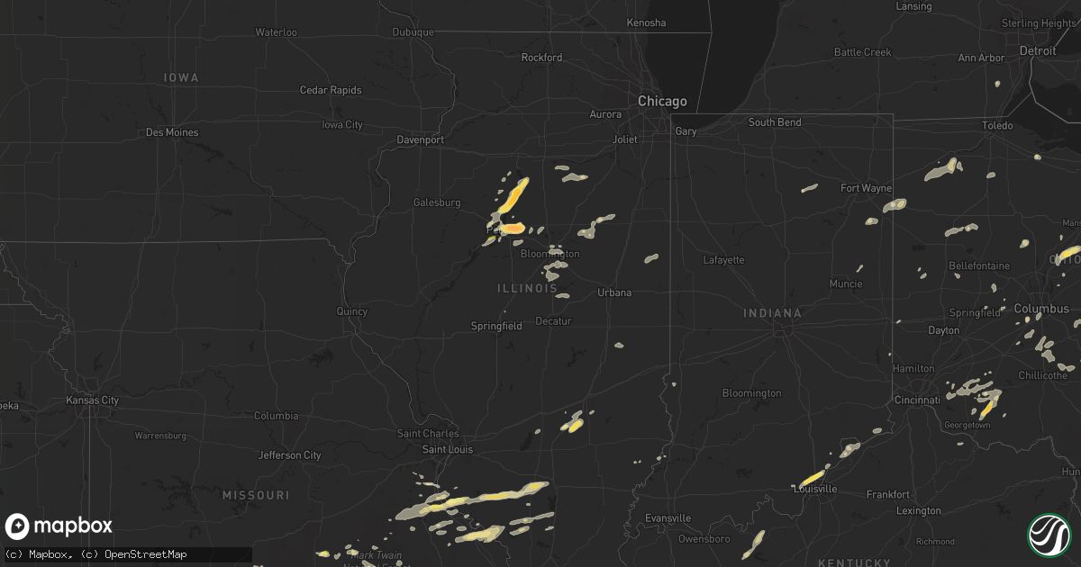
Hail Map in Illinois on August 20, 2022
Get this storm
August 20 map
$229
one time, instant access
Download today. No call, no setup
Keep the $229
Bought the map and want the full workflow? Apply the entire $229 to a subscription within 7 days. None of it is wasted.
Every map, not just this one
This buys you this map. Subscription and you get every map we run, in the markets you choose from a few cities to whole states to nationwide. Plus real-time alerts the moment a storm fires.
Contact data
Name, contact info, occupancy, even credit band for addresses in the footprint. You go from where it hit to who to call.
Become the source they trust
Unlimited branding weather history reports on demand. You already have the documented answer ready for the property owner, and you are the one who showed up with it.
Property data and RoofTrace estimates
Pull up any address you have got, its value and the exact code rules for that jurisdiction, straight from One Click Code. Then RoofTrace estimates the squares, pitch, and roof value, priced the way you price.
Storm reports in Illinois
Illinois
| Date | Description |
|---|---|
| 08/20/20222:55 PM CDT | Siding damaged. |
| 08/20/20222:45 PM CDT | A local report indicates 2.00 inch wind near 1 NW WASHINGTON |
| 08/20/20222:45 PM CDT | Report of estimated penny to quarter size hail. |
| 08/20/20222:43 PM CDT | Report from mping: golf ball |
| 08/20/20222:40 PM CDT | A local report indicates 3.00 inch wind near WASHINGTON |
| 08/20/20222:39 PM CDT | A local report indicates 1.00 inch wind near 3 W WASHINGTON |
| 08/20/20222:35 PM CDT | A local report indicates 1.50 inch wind near 4 ENE EAST PEORIA |
| 08/20/20222:33 PM CDT | Estimated 60 mph. |
| 08/20/20222:32 PM CDT | Report from mping: 1-inch tree limbs broken; shingles blown off. |
| 08/20/20222:30 PM CDT | Large windows broken and metal roofing damaged. Time estimated. |
| 08/20/20222:30 PM CDT | 12 inch tree limb broke off and damaged roof. |
| 08/20/20222:30 PM CDT | A local report indicates 1.00 inch wind near 4 SE PEORIA HEIGHTS |
| 08/20/20222:20 PM CDT | Estimated from picture. |
| 08/20/20222:20 PM CDT | Report from mping: 3-inch tree limbs broken; power poles broken. |
| 08/20/20222:20 PM CDT | A local report indicates 1.75 inch wind near SPARLAND |
| 08/20/20222:20 PM CDT | A local report indicates 1.25 inch wind near LACON |
| 08/20/20222:05 PM CDT | Trained spotter reported multi vortex tornado in corn field kicking up some debris. Started to become rain wrapped again at end of report. |
| 08/20/20222:05 PM CDT | Corrects previous tornado report from 3 se gingle corners. Trained spotter reported multi vortex tornado in corn field kicking up some debris. Started to become rain wr |
| 08/20/20222:00 PM CDT | Quarter size hail mixed with smaller hail. |
| 08/20/20221:55 PM CDT | Storm chasers reported a brief touchdown near aledo... But quickly got rain wrapped. No damage reported at this time. |
| 08/20/20221:17 PM CDT | Corrects previous funnel cloud report from 3 sse mannon. Chaser reported that funnel cloud lasted 2 minutes at this location and eventually touched down briefly. Photo |
| 08/20/20226:57 AM CDT | At 1156 PM CDT, a severe thunderstorm was located over Coulterville, moving east at 45 mph. HAZARD...60 mph wind gusts and quarter size hail. SOURCE...Radar indicated. IMPACT...Hail damage to vehicles is expected. Expect wind damage to roofs, siding, and trees. Locations impacted include... Oakdale, Posen, Radom, Ashley and Du Bois. |
| 08/20/20226:53 AM CDT | At 1153 PM CDT, a severe thunderstorm was located over Coulterville, or 7 miles east of Sparta, moving east at 35 mph. HAZARD...60 mph wind gusts and quarter size hail. SOURCE...Radar indicated. IMPACT...Hail damage to vehicles is expected. Expect wind damage to roofs, siding, and trees. Locations impacted include... Tamaroa. |
| 08/20/20226:46 AM CDT | At 1146 PM CDT, a severe thunderstorm was located over Tilden, moving east at 40 mph. HAZARD...60 mph wind gusts and quarter size hail. SOURCE...Radar indicated. IMPACT...Hail damage to vehicles is expected. Expect wind damage to roofs, siding, and trees. Locations impacted include... Sparta, Coulterville, Tilden, Eden and Houston. |
| 08/20/20222:29 AM CDT | At 729 PM CDT, a severe thunderstorm was located near Hoopeston, or 13 miles south of Milford, moving northeast at 30 mph. HAZARD...60 mph wind gusts and quarter size hail. SOURCE...Radar indicated. IMPACT...Hail damage to vehicles is expected. Expect wind damage to roofs, siding, and trees. This severe thunderstorm will be near... Rossville around 735 PM CDT. Hoopeston around 745 PM CDT. |
| 08/20/20221:00 AM CDT | Several large trees down. One tree snapped near base. Several others lost large limbs. Late report. |
| 08/20/202212:52 AM CDT | At 551 PM CDT, a severe thunderstorm was located over Iola, or 16 miles northwest of Flora, moving northeast at 25 mph. HAZARD...60 mph wind gusts and quarter size hail. SOURCE...Radar indicated. IMPACT...Hail damage to vehicles is expected. Expect wind damage to roofs, siding, and trees. This severe thunderstorm will be near... Edgewood around 555 PM CDT. Bible Grove around 610 PM CDT. Watson around 620 PM CDT. Dieterich around 630 PM CDT.Other locations impacted by this severe thunderstorm include Hord,Mason, Effingham County Airport, Heartville and Elliotstown.This includes the following highways... Interstate 57 between mile markers 142 and 163. Interstate 70 between mile markers 91 and 98. |
| 08/19/202210:26 PM CDT | At 326 PM CDT, a severe thunderstorm was located near Grand Ridge, or 7 miles northeast of Streator, moving northeast at 15 mph. HAZARD...60 mph wind gusts and quarter size hail. SOURCE...Radar indicated. IMPACT...Hail damage to vehicles is expected. Expect wind damage to roofs, siding, and trees. Locations impacted include... Marseilles, Seneca, Mazon, Grand Ridge, Ransom, Verona and Kinsman.Including the following interstates... I-55 near mile marker 222. I-80 between mile markers 106 and 107. |
| 08/19/202210:25 PM CDT | Corrects previous tstm wnd dmg report from 1 ne valier. Several large trees down. One tree snapped near base. Several others lost large limbs. Late report. Corrected ti |
| 08/19/20229:33 PM CDT | At 233 PM CDT, a severe thunderstorm was located over Washington, or 8 miles east of Peoria, moving east at 25 mph. HAZARD...60 mph wind gusts and quarter size hail. SOURCE...Radar indicated. IMPACT...Hail damage to vehicles is expected. Expect wind damage to roofs, siding, and trees. This severe thunderstorm will be near... Metamora around 245 PM CDT. Eureka around 255 PM CDT. Goodfield around 300 PM CDT. Roanoke around 310 PM CDT. Secor around 315 PM CDT. |
| 08/19/20229:30 PM CDT | At 230 PM CDT, severe thunderstorms were located along a line extending from Swedona to near New Windsor to Eleanor, moving east at 20 mph. HAZARD...60 mph wind gusts and quarter size hail. SOURCE...Radar indicated. IMPACT...Hail damage to vehicles is expected. Expect wind damage to roofs, siding, and trees. Severe thunderstorms will be near... New Windsor, North Henderson, New Windsor, Cable, Swedona and Griffin around 235 PM CDT. Orion and Ophiem around 240 PM CDT. Alpha and Lynn Center around 245 PM CDT.Other locations in the path of these severe thunderstorms includeWoodhull, Andover, Cambridge, Henry County Fairgrounds, Ulah andNekoma. |
| 08/19/20229:26 PM CDT | At 226 PM CDT, a severe thunderstorm was located over Marshall County Airport, or near Lacon, moving northeast at 35 mph. HAZARD...60 mph wind gusts and quarter size hail. SOURCE...Trained weather spotters. IMPACT...Hail damage to vehicles is expected. Expect wind damage to roofs, siding, and trees. This severe thunderstorm will be near... Magnolia around 240 PM CDT.Other locations in the path of this severe thunderstorm includeMcNabb, Florid, Hennepin, Granville, Mark and Standard. |
| 08/19/20228:53 PM CDT | At 153 PM CDT, a severe thunderstorm was located over Rome, or 8 miles north of Peoria, moving northeast at 35 mph. HAZARD...60 mph wind gusts and quarter size hail. SOURCE...Radar indicated. IMPACT...Hail damage to vehicles is expected. Expect wind damage to roofs, siding, and trees. This severe thunderstorm will be near... Chillicothe around 205 PM CDT. Lacon, Washburn and Sparland around 215 PM CDT. Henry around 225 PM CDT. Varna around 230 PM CDT. Toluca around 235 PM CDT.Other locations impacted by this severe thunderstorm includeMossville, La Rose, Lake Wildwood, Marshall-Putnam CountyFairgrounds, Hopewell, Pattonsburg, Low Point, Marshall CountyAirport, Cazenovia and Peoria Heights. |
All States Impacted by Hail Map on August 20, 2022
Cities Impacted by Hail Map on August 20, 2022
- Goshen, OH
- Florence, IN
- Vevay, IN
- Earlville, NY
- Smyrna, NY
- Clyde, OH
- Fremont, OH
- Yorkshire, OH
- Metamora, IL
- Mount Carmel, IL
- West Salem, IL
- Centerburg, OH
- Croton, OH
- Belgrade, MO
- Potosi, MO
- Marlette, MI
- Kingston, MI
- Snover, MI
- Towanda, IL
- Normal, IL
- Sainte Genevieve, MO
- Kingston, OH
- South Bloomingville, OH
- Laurelville, OH
- Salem, MO
- Norwood, MO
- Cygnet, OH
- Bloomdale, OH
- North Baltimore, OH
- Augusta, KY
- Germantown, KY
- Maynard, AR
- Pocahontas, AR
- Cardington, OH
- Marengo, OH
- Fulton, OH
- Mount Gilead, OH
- Fredericktown, OH
- Chesterville, OH
- Bellville, OH
- Auburntown, TN
- Woodbury, TN
- Rockvale, TN
- Murfreesboro, TN
- Convoy, OH
- Monroeville, IN
- Land O'Lakes, FL
- Lutz, FL
- Odessa, FL
- Mountain Grove, MO
- Hartville, MO
- Hillsboro, OH
- Boonville, NY
- Hawthorne, FL
- Orient, OH
- Ashville, OH
- Mount Sterling, OH
- Milton, TN
- Brownsville, TN
- Patterson, MO
- Lithia, FL
- Prairie Du Rocher, IL
- Edwards, IL
- Hanna City, IL
- Peoria, IL
- Bonne Terre, MO
- Harrod, OH
- Forrest, IL
- Chatsworth, IL
- Congress, AZ
- Wittmann, AZ
- Ransom, IL
- Streator, IL
- Tuskegee, AL
- Union Springs, AL
- Luverne, AL
- Russia, OH
- Versailles, OH
- Littlefield, AZ
- Verona, IL
- Kinsman, IL
- Dunlap, IL
- McNabb, IL
- Varna, IL
- Hennepin, IL
- Magnolia, IL
- Putnam, IL
- Lacon, IL
- Chillicothe, IL
- Henry, IL
- Washburn, IL
- Edelstein, IL
- Sparland, IL
- McLean, IL
- Marion, OH
- Pleasant Plain, OH
- Cable, OH
- North Lewisburg, OH
- Mechanicsburg, OH
- Woodstock, OH
- Mount Orab, OH
- Blanchester, OH
- New Vienna, OH
- Martinsville, OH
- Lynchburg, OH
- Williamsburg, OH
- Fayetteville, OH
- Midland, OH
- Defiance, OH
- Dunkirk, IN
- Albany, IN
- Redkey, IN
- Rankin, IL
- Rossville, IL
- Hoopeston, IL
- Grove City, OH
- Columbus, OH
- Speer, IL
- Bradford, IL
- Paragonah, UT
- Grovespring, MO
- Lebanon, MO
- Mineral Point, MO
- Irondale, MO
- Bolivar, NY
- Little Genesee, NY
- Seaman, OH
- Sardinia, OH
- Winchester, OH
- Craigville, IN
- Bluffton, IN
- Decatur, IN
- Waynesville, IL
- Heyworth, IL
- Downs, IL
- Le Roy, IL
- Shirley, IL
- Wapella, IL
- Bloomington, IL
- Vanzant, MO
- Pomona, MO
- Willow Springs, MO
- Richfield, UT
- New Paris, OH
- Dalton, GA
- Chatsworth, GA
- Congerville, IL
- Eureka, IL
- Charleston, IL
- Arcadia, MO
- Vulcan, MO
- Centerville, MO
- Ellington, MO
- Lesterville, MO
- Redford, MO
- Annapolis, MO
- Elkville, IL
- Ava, IL
- De Soto, IL
- Vergennes, IL
- Murphysboro, IL
- Peebles, OH
- Lodi, MO
- Colorado City, AZ
- Farmington, MO
- Hillsboro, MO
- Oakdale, IL
- Woodlawn, IL
- Tamaroa, IL
- Du Bois, IL
- Pinckneyville, IL
- Baldwin, IL
- Coulterville, IL
- Nashville, IL
- Ashley, IL
- Sparta, IL
- Decker, MI
- Cass City, MI
- Deford, MI
- London, OH
- Charleston, WV
- Poca, WV
- Kenna, WV
- Bloomsdale, MO
- Georgetown, IN
- Corydon, IN
- Colfax, IL
- Chenoa, IL
- Cropsey, IL
- Fairbury, IL
- Patoka, IL
- Vandalia, IL
- Vernon, IL
- Leesburg, OH
- Phelps, NY
- Standish, MI
- Maybee, MI
- Monroe, MI
- Glasford, IL
- Manito, IL
- Mapleton, IL
- Kingston Mines, IL
- Springfield, OH
- Modoc, IL
- Surprise, AZ
- Red Bud, IL
- Blackwell, MO
- Cadet, MO
- French Village, MO
- Valles Mines, MO
- Evansville, IL
- Festus, MO
- Fults, IL
- Valmeyer, IL
- De Soto, MO
- Mount Vernon, IL
- Waltonville, IL
- Gordon, WV
- Bob White, WV
- Van, WV
- Twilight, WV
- Madison, WV
- Claypool, IN
- Pierceton, IN
- Silver Lake, IN
- Port Allegany, PA
- Turtlepoint, PA
- Scott, OH
- Van Wert, OH
- Galion, OH
- Longmont, CO
- Mead, CO
- Logan, OH
- Calamus, IA
- Wheatland, IA
- Dixon, IA
- New Liberty, IA
- Williamsport, OH
- Circleville, OH
- Morton, IL
- Deer Creek, IL
- Tremont, IL
- Mackinaw, IL
- Creve Coeur, IL
- Peoria Heights, IL
- East Peoria, IL
- Washington, IL
- El Paso, IL
- Secor, IL
- Wapakoneta, OH
- Lima, OH
- Boss, MO
- Bixby, MO
- Thurston, OH
- Millersport, OH
- Baltimore, OH
- Lancaster, OH
- Pleasantville, OH
- Sidney, OH
- Quincy, OH
- Pekin, IL
- Van Buren, MO
- Bennett, IA
- McGuffey, OH
- Alger, OH
- Ada, OH
- Georgetown, OH
- Lachine, MI
- Hanksville, UT
- Dowell, IL
- Benton, IL
- Christopher, IL
- Mulkeytown, IL
- Buckner, IL
- Du Quoin, IL
- Malinta, OH
- Deshler, OH
- Hamler, OH
- Roseville, OH
- New Bavaria, OH
- Napoleon, OH
- Continental, OH
- Holgate, OH
- Oakwood, OH
- Grand Ridge, IL
- Ottawa, IL
- Marseilles, IL
- Armada, MI
- Ava, NY
- Lee Center, NY
- House Springs, MO
- Cambridge, OH
- Dieterich, IL
- Saint Elmo, IL
- Eminence, MO
- Hartshorn, MO
- Raymondville, MO
- Grand Marais, MI
- Farmersburg, IN
- Licking, MO
- Thomaston, GA
- Thompsons Station, TN
- Franklin, TN
- Lenox, MO
- Lascassas, TN
- Gainesville, FL
- Brooker, FL
- Meadview, AZ
- Fort Payne, AL
- Valley Head, AL
- Mentone, AL
- Bradyville, TN
- Windermere, FL
- Winter Garden, FL
- Orlando, FL
- Hopewell, OH
- Mount Perry, OH
- Zanesville, OH
- Heath, OH
- Somerset, OH
- Glennville, GA
- Frazeysburg, OH
- Dresden, OH
- Nashport, OH
- Kingman, AZ
- Saint Mary, MO
- Campbell Hill, IL
- Chester, IL
- Perryville, MO
- Rockwood, IL
- Wappapello, MO
- Greenville, MO
- Williamsville, MO
- Bedford, KY
- Morrison, TN
- Koshkonong, MO
- Mammoth Spring, AR
- Salem, AR
- Camp, AR
- Thayer, MO
- West Plains, MO
- Fitzpatrick, AL
- Pevely, MO
- Barnhart, MO
- Saint Peter, IL
- Berryville, AR
- Eureka Springs, AR
- Iowa Park, TX
- Quanah, TX
- Welch, TX
- Clarksville, IN
- New Albany, IN
- Sellersburg, IN
- Floyds Knobs, IN
- Charlestown, IN
- Jeffersonville, IN
- West Fork, AR
- Fayetteville, AR
- Farina, IL
- Fordsville, KY
- Hardinsburg, KY
- Falls Of Rough, KY
- Harned, KY
- Saint Petersburg, FL
- Aguila, AZ
- Wickenburg, AZ
- Lake Park, GA
- Valdosta, GA
- Bunker, MO
- Herculaneum, MO
- Ocala, FL
- Odum, GA
- Pinson, TN
- Ray City, GA
- Hahira, GA
- Henderson, TN
- Hornsby, TN
- Piper City, IL
- Williamsville, IL
- Kimbolton, OH
- Milton, KY
- Edgewood, IL
- Springfield, MO
- Dowelltown, TN
- Smithville, TN
- Liberty, TN
- Kinmundy, IL
- Herrin, IL
- West Frankfort, IL
- Edgar Springs, MO
- Peach Orchard, AR
- Delaplaine, AR
- Paragould, AR
- Conifer, CO
- Birch Tree, MO
- Vincennes, IN
- Columbia, TN
- Spring Hill, TN
- Seligman, AZ
- Sturkie, AR
- Beechgrove, TN
- Mcminnville, TN
- Manchester, TN
- Columbia, AL
- Abbeville, AL
- Waterloo, IL
- Fredericktown, MO
- Frohna, MO
- Liberty, IN
- West College Corner, IN
- Bristol, FL
- Saint George, UT
- Winona, MO
- Fremont, MO
- Allendale, IL
- Auburn, AL
- Waverly, AL
- Alachua, FL
- Beech Bluff, TN
- Huron, TN
- Lexington, TN
- Maroa, IL
- Clinton, IL
- Weldon, IL
- South Vienna, OH
- Stoutsville, OH
- Floral City, FL
- Macon, MS
- Sulligent, AL
- Detroit, AL
- Prairie Grove, AR
- Farmington, AR
- Chiefland, FL
- Bronson, FL
- Lanesville, IN
- New Lexington, OH
- Batavia, OH
- Owensville, OH
- Mason, IL
- Nabb, IN
- Marysville, IN
- Bethlehem, IN
- New Washington, IN
- Carrollton, KY
- Caneyville, KY
- Mill Spring, MO
- Colcord, OK
- Bagdad, AZ
- Lake Butler, FL
- College Grove, TN
- Folkston, GA
- Reform, AL
- Fargo, GA
- Lake City, FL
- Cisco, GA
- Washington Court House, OH
- Bolivar, TN
- Finger, TN
- Seagrove, NC
- Brownfield, TX
- Morrison, CO
- Goodlettsville, TN
- Warsaw, OH
- Fresno, OH
- Coshocton, OH
- Galena, OH
- Lovington, NM
- Gordo, AL
- Menlo, GA
- Summerville, GA
- Littleton, CO
- Cadiz, OH
- Hopedale, OH
- Freeport, OH
- Quaker City, OH
- Piedmont, OH
- Kipling, OH
- Flushing, OH
- Saint Clairsville, OH
- Lore City, OH
- Barnesville, OH
- Salesville, OH
- Jewett, OH
- Cumberland, OH
- Byesville, OH
- Old Washington, OH
- New Concord, OH
- Marshfield, MO


