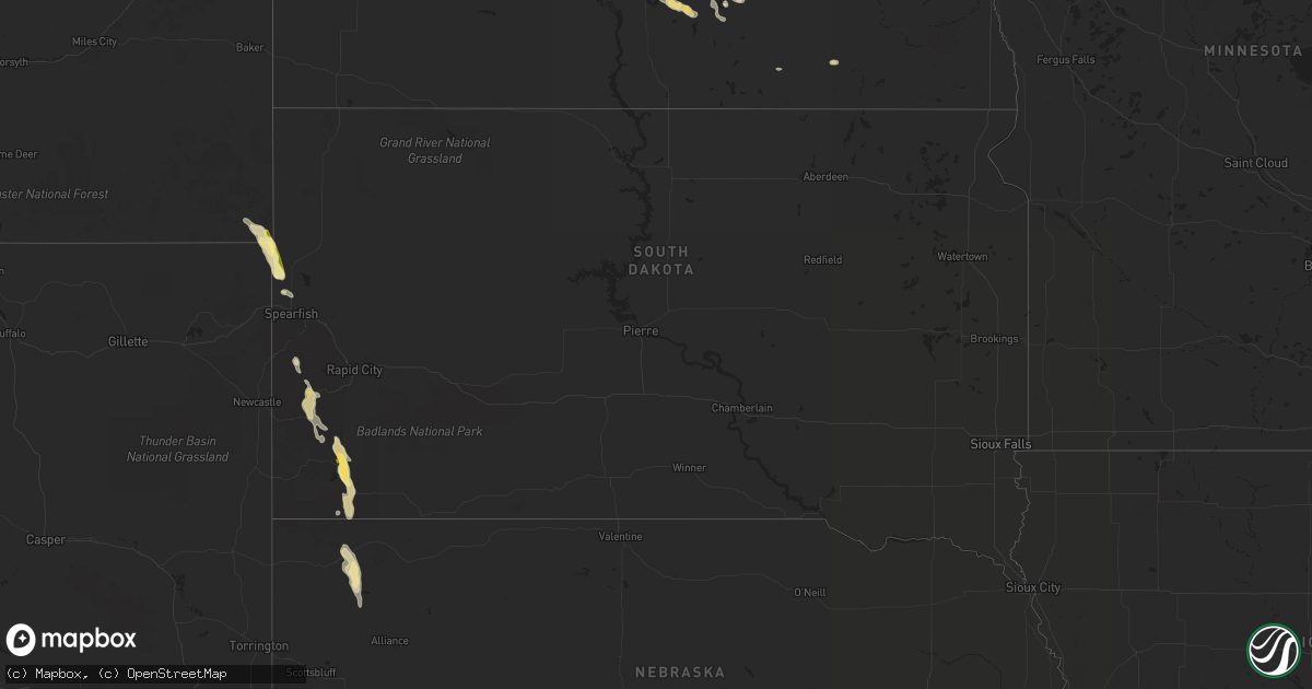
Hail Map in South Dakota on August 17, 2022
Get this storm
August 17 map
$229
one time, instant access
Download today. No call, no setup
Keep the $229
Bought the map and want the full workflow? Apply the entire $229 to a subscription within 7 days. None of it is wasted.
Every map, not just this one
This buys you this map. Subscription and you get every map we run, in the markets you choose from a few cities to whole states to nationwide. Plus real-time alerts the moment a storm fires.
Contact data
Name, contact info, occupancy, even credit band for addresses in the footprint. You go from where it hit to who to call.
Become the source they trust
Unlimited branding weather history reports on demand. You already have the documented answer ready for the property owner, and you are the one who showed up with it.
Property data and RoofTrace estimates
Pull up any address you have got, its value and the exact code rules for that jurisdiction, straight from One Click Code. Then RoofTrace estimates the squares, pitch, and roof value, priced the way you price.
Storm reports in South Dakota
South Dakota
| Date | Description |
|---|---|
| 08/17/20226:19 PM CDT | A local report indicates 60 MPH wind near 3 NW WASTA |
| 08/17/20225:28 PM CDT | A local report indicates 60 MPH wind near 1 NNE FAITH |
| 08/17/20223:55 PM CDT | A local report indicates 62 MPH wind near 7 WSW HOOVER |
| 08/17/20223:49 PM CDT | A local report indicates 68 MPH wind near 13 NW BELLE FOURCHE |
| 08/17/20223:44 PM CDT | A local report indicates 62 MPH wind near 13 NW BELLE FOURCHE |
| 08/17/20223:30 PM CDT | A local report indicates 60 MPH wind near 13 NW BELLE FOURCHE RES |
| 08/16/20229:44 PM CDT | At 244 PM MDT, a severe thunderstorm was located 10 miles east of Colony, or 12 miles northwest of Belle Fourche, moving southeast at 30 mph. HAZARD...70 mph wind gusts and half dollar size hail. SOURCE...Radar indicated. IMPACT...Hail damage to vehicles is expected. Expect considerable tree damage. Wind damage is also likely to mobile homes, roofs, and outbuildings. Locations impacted include... Spearfish, Belle Fourche, Whitewood, Saint Onge, Fruitdale, Belle Fourche Reservoir, Bridal Veil Falls and northern Spearfish Canyon.This includes Interstate 90 in South Dakota between Mile Markers 6and 24. |
All States Impacted by Hail Map on August 17, 2022
Cities Impacted by Hail Map on August 17, 2022
- Williston, ND
- Grenora, ND
- Edgemont, SD
- Akron, NY
- Corfu, NY
- Towner, ND
- Isanti, MN
- Northome, MN
- Voltaire, ND
- Livonia, NY
- Fullerton, ND
- Squaw Lake, MN
- Penn Yan, NY
- Dundee, NY
- Dateland, AZ
- Buckeye, AZ
- Gila Bend, AZ
- Bradford, PA
- Waxahachie, TX
- Wright, MN
- Cromwell, MN
- Minot, ND
- Orange City, FL
- Meridian, TX
- Clifton, TX
- Moscow, TX
- Oral, SD
- Hot Springs, SD
- Buffalo Gap, SD
- Oelrichs, SD
- Fort Worth, TX
- Ajo, AZ
- Cleburne, TX
- Alvarado, TX
- Bell, FL
- Streeter, ND
- Ferris, TX
- Tyler, TX
- Andalusia, AL
- Wing, AL
- Daphne, AL
- Mobile, AL
- Ocala, FL
- Larue, TX
- Randolph, NY
- Stanley, NY
- Huntington, TX
- Grygla, MN
- Waterloo, NY
- Kettle River, MN
- Rush, CO
- Cambridge, MN
- Calvin, ND
- Rocklake, ND
- Munich, ND
- Egeland, ND
- Rugby, ND
- Wellsville, NY
- Rosemount, MN
- Inver Grove Heights, MN
- Newport, MN
- South Saint Paul, MN
- Farmington, MN
- Saint Paul, MN
- Whitesville, NY
- Rexville, NY
- Andover, NY
- Millsap, TX
- Weatherford, TX
- Santo, TX
- Vancleave, MS
- Esmond, ND
- Sturgeon Lake, MN
- Summerfield, FL
- Belleview, FL
- Barnum, MN
- Dagmar, MT
- Froid, MT
- Bainville, MT
- Crockett, TX
- Kennard, TX
- Belle Fourche, SD
- Conchas Dam, NM
- Avoca, NY
- Bath, NY
- Ennis, TX
- Palmer, TX
- Jena, LA
- Heidelberg, MS
- Vossburg, MS
- Branford, FL
- Alden, NY
- Lancaster, NY
- Batavia, NY
- Alexander, NY
- Mount Joy, PA
- Manheim, PA
- Kaycee, WY
- Cave Creek, AZ
- Dry Prong, LA
- Colfax, LA
- Bentley, LA
- Rusk, TX
- Godley, TX
- Joshua, TX
- Westby, MT
- Lead, SD
- Harleton, TX
- Mineola, TX
- Winnsboro, TX
- Quitman, TX
- Lufkin, TX
- Jacksonville, TX
- Crawford, NE
- Whitney, NE
- Grandy, MN
- Stanchfield, MN
- Union Church, MS
- McCall Creek, MS
- Douglass, TX
- Cushing, TX
- Grand Cane, LA
- Trenton, FL
- Saint Johns, FL
- Saint Augustine, FL
- Steele, ND
- Kintyre, ND
- Napoleon, ND
- Alzada, MT
- Culbertson, MT
- Dunseith, ND
- Mcgregor, MN
- Tamarack, MN
- Carrabelle, FL
- Jacksonville, FL
- Moose Lake, MN
- Spearfish, SD
- Saint Onge, SD
- Hill City, SD
- Custer, SD
- Grand Prairie, TX
- Cedar Hill, TX
- Dallas, TX
- Braddock, ND
- Bisbee, ND
- Austin, PA
- Frisco City, AL
- Atmore, AL
- Fairview, MT
- Wibaux, MT
- Pringle, SD
- Desoto, TX
- Red Oak, TX
- Hawkins, TX
- Tappen, ND
- Midlothian, TX
- Scroggins, TX
- Venus, TX
- Sells, AZ
- Livingston, TX
- Uriah, AL
- Winona, TX
- Clarence, NY
- Sacramento, PA
- Lykens, PA
- Klingerstown, PA
- Watford City, ND
- Medina, ND
- Mexia, TX
- Moss Point, MS
- Clayton, LA
- Oil City, LA
- Mooringsport, LA
- Lancaster, TX
- Mayo, FL
- Braham, MN
- Grasston, MN
- Belcourt, ND
- Geneva, NY
- Zavalla, TX
- Prattsburgh, NY
- Cloquet, MN
- Jasper, TX
- Theodore, AL
- Grand Bay, AL
- Marsland, NE
- Mylo, ND
- Rolette, ND
- Wolf Creek, OR
- Palatka, FL
- Kulm, ND
- Wirt, MN
- Sawyer, MN
- Eight Mile, AL
- Killdeer, ND
- Antelope, MT
- Plentywood, MT
- Reserve, MT
- Medicine Lake, MT
- Grandview, TX
- Sturgis, SD
- Piedmont, SD
- Hemingford, NE
- Silverhill, AL
- Natchez, MS
- Fayette, MS
- Niceville, FL
- Freeport, FL


