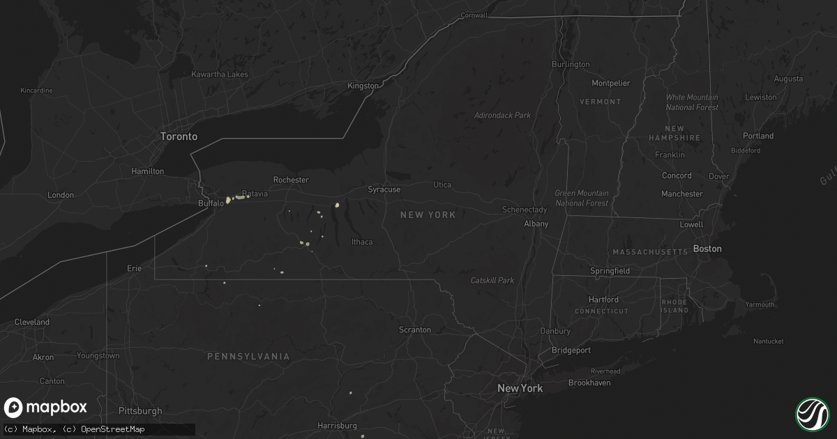
Hail Map in New York on August 17, 2022
Get this storm
August 17 map
$229
one time, instant access
Download today. No call, no setup
Keep the $229
Bought the map and want the full workflow? Apply the entire $229 to a subscription within 7 days. None of it is wasted.
Every map, not just this one
This buys you this map. Subscription and you get every map we run, in the markets you choose from a few cities to whole states to nationwide. Plus real-time alerts the moment a storm fires.
Contact data
Name, contact info, occupancy, even credit band for addresses in the footprint. You go from where it hit to who to call.
Become the source they trust
Unlimited branding weather history reports on demand. You already have the documented answer ready for the property owner, and you are the one who showed up with it.
Property data and RoofTrace estimates
Pull up any address you have got, its value and the exact code rules for that jurisdiction, straight from One Click Code. Then RoofTrace estimates the squares, pitch, and roof value, priced the way you price.
Storm reports in New York
New York
| Date | Description |
|---|---|
| 08/17/20224:15 PM CDT | Large tree snapped on green st between ferry and rensselaer ave. Radar time estimated. |
| 08/17/20224:12 PM CDT | Several trees and power lines down on columbia street on the lower end of the city. |
| 08/17/20224:00 PM CDT | Trees and wires down. |
| 08/17/202212:23 AM CDT | At 523 PM EDT, a severe thunderstorm was located over Waterloo, and is nearly stationary. HAZARD...60 mph wind gusts and quarter size hail. SOURCE...Radar indicated. IMPACT...Hail damage to vehicles is expected. Expect wind damage to roofs, siding, and trees. Locations impacted include... Seneca Falls, Waterloo, Packwood Corners and Rose Hill. |
| 08/17/202212:11 AM CDT | At 511 PM EDT, a severe thunderstorm was located over Caywood, or 9 miles east of Dundee, moving west at 10 mph. HAZARD...60 mph wind gusts and quarter size hail. SOURCE...Radar indicated. IMPACT...Hail damage to vehicles is expected. Expect wind damage to roofs, siding, and trees. Locations impacted include... Lodi, Caywood, Townsendville, Lodi Station, Lodi Point State Park and East Steamburg. |
| 08/17/202212:10 AM CDT | At 509 PM EDT, a severe thunderstorm was located over Menands, or over Watervliet, moving south at 20 mph. HAZARD...60 mph wind gusts and quarter size hail. SOURCE...Radar indicated. IMPACT...Hail damage to vehicles is expected. Expect wind damage to roofs, siding, and trees. Locations impacted include... Albany, Troy, East Greenbush, Cohoes, Watervliet, Rensselaer, Colonie, Nassau, Latham, Delmar, Menands, Ravena, Green Island, Castleton-On-Hudson, Loudonville, West Sand Lake, Center Brunswick, Wyantskill, Selkirk and Wynantskill. |
| 08/17/202212:00 AM CDT | At 500 PM EDT, a severe thunderstorm was located over Pembroke, or near Darien Lakes State Park, moving southwest at 10 mph. HAZARD...60 mph wind gusts and quarter size hail. SOURCE...Radar indicated. IMPACT...Minor damage to vehicles is possible. Expect wind damage to trees and power lines. Locations impacted include... Darien Lakes State Park, Pembroke, Akron, Alden, Corfu and East Pembroke.This includes Interstate 90 near exit 48A. |
| 08/16/202211:17 PM CDT | At 417 PM EDT, a severe thunderstorm was located near Batavia, moving southwest at 10 mph. HAZARD...60 mph wind gusts and quarter size hail. SOURCE...Radar indicated. IMPACT...Minor damage to vehicles is possible. Expect wind damage to trees and power lines. Locations impacted include... Darien Lakes State Park, Attica, Corfu, Alexander and East Pembroke. |
All States Impacted by Hail Map on August 17, 2022
Cities Impacted by Hail Map on August 17, 2022
- Williston, ND
- Grenora, ND
- Edgemont, SD
- Akron, NY
- Corfu, NY
- Towner, ND
- Isanti, MN
- Northome, MN
- Voltaire, ND
- Livonia, NY
- Fullerton, ND
- Squaw Lake, MN
- Penn Yan, NY
- Dundee, NY
- Dateland, AZ
- Buckeye, AZ
- Gila Bend, AZ
- Bradford, PA
- Waxahachie, TX
- Wright, MN
- Cromwell, MN
- Minot, ND
- Orange City, FL
- Meridian, TX
- Clifton, TX
- Moscow, TX
- Oral, SD
- Hot Springs, SD
- Buffalo Gap, SD
- Oelrichs, SD
- Fort Worth, TX
- Ajo, AZ
- Cleburne, TX
- Alvarado, TX
- Bell, FL
- Streeter, ND
- Ferris, TX
- Tyler, TX
- Andalusia, AL
- Wing, AL
- Daphne, AL
- Mobile, AL
- Ocala, FL
- Larue, TX
- Randolph, NY
- Stanley, NY
- Huntington, TX
- Grygla, MN
- Waterloo, NY
- Kettle River, MN
- Rush, CO
- Cambridge, MN
- Calvin, ND
- Rocklake, ND
- Munich, ND
- Egeland, ND
- Rugby, ND
- Wellsville, NY
- Rosemount, MN
- Inver Grove Heights, MN
- Newport, MN
- South Saint Paul, MN
- Farmington, MN
- Saint Paul, MN
- Whitesville, NY
- Rexville, NY
- Andover, NY
- Millsap, TX
- Weatherford, TX
- Santo, TX
- Vancleave, MS
- Esmond, ND
- Sturgeon Lake, MN
- Summerfield, FL
- Belleview, FL
- Barnum, MN
- Dagmar, MT
- Froid, MT
- Bainville, MT
- Crockett, TX
- Kennard, TX
- Belle Fourche, SD
- Conchas Dam, NM
- Avoca, NY
- Bath, NY
- Ennis, TX
- Palmer, TX
- Jena, LA
- Heidelberg, MS
- Vossburg, MS
- Branford, FL
- Alden, NY
- Lancaster, NY
- Batavia, NY
- Alexander, NY
- Mount Joy, PA
- Manheim, PA
- Kaycee, WY
- Cave Creek, AZ
- Dry Prong, LA
- Colfax, LA
- Bentley, LA
- Rusk, TX
- Godley, TX
- Joshua, TX
- Westby, MT
- Lead, SD
- Harleton, TX
- Mineola, TX
- Winnsboro, TX
- Quitman, TX
- Lufkin, TX
- Jacksonville, TX
- Crawford, NE
- Whitney, NE
- Grandy, MN
- Stanchfield, MN
- Union Church, MS
- McCall Creek, MS
- Douglass, TX
- Cushing, TX
- Grand Cane, LA
- Trenton, FL
- Saint Johns, FL
- Saint Augustine, FL
- Steele, ND
- Kintyre, ND
- Napoleon, ND
- Alzada, MT
- Culbertson, MT
- Dunseith, ND
- Mcgregor, MN
- Tamarack, MN
- Carrabelle, FL
- Jacksonville, FL
- Moose Lake, MN
- Spearfish, SD
- Saint Onge, SD
- Hill City, SD
- Custer, SD
- Grand Prairie, TX
- Cedar Hill, TX
- Dallas, TX
- Braddock, ND
- Bisbee, ND
- Austin, PA
- Frisco City, AL
- Atmore, AL
- Fairview, MT
- Wibaux, MT
- Pringle, SD
- Desoto, TX
- Red Oak, TX
- Hawkins, TX
- Tappen, ND
- Midlothian, TX
- Scroggins, TX
- Venus, TX
- Sells, AZ
- Livingston, TX
- Uriah, AL
- Winona, TX
- Clarence, NY
- Sacramento, PA
- Lykens, PA
- Klingerstown, PA
- Watford City, ND
- Medina, ND
- Mexia, TX
- Moss Point, MS
- Clayton, LA
- Oil City, LA
- Mooringsport, LA
- Lancaster, TX
- Mayo, FL
- Braham, MN
- Grasston, MN
- Belcourt, ND
- Geneva, NY
- Zavalla, TX
- Prattsburgh, NY
- Cloquet, MN
- Jasper, TX
- Theodore, AL
- Grand Bay, AL
- Marsland, NE
- Mylo, ND
- Rolette, ND
- Wolf Creek, OR
- Palatka, FL
- Kulm, ND
- Wirt, MN
- Sawyer, MN
- Eight Mile, AL
- Killdeer, ND
- Antelope, MT
- Plentywood, MT
- Reserve, MT
- Medicine Lake, MT
- Grandview, TX
- Sturgis, SD
- Piedmont, SD
- Hemingford, NE
- Silverhill, AL
- Natchez, MS
- Fayette, MS
- Niceville, FL
- Freeport, FL


