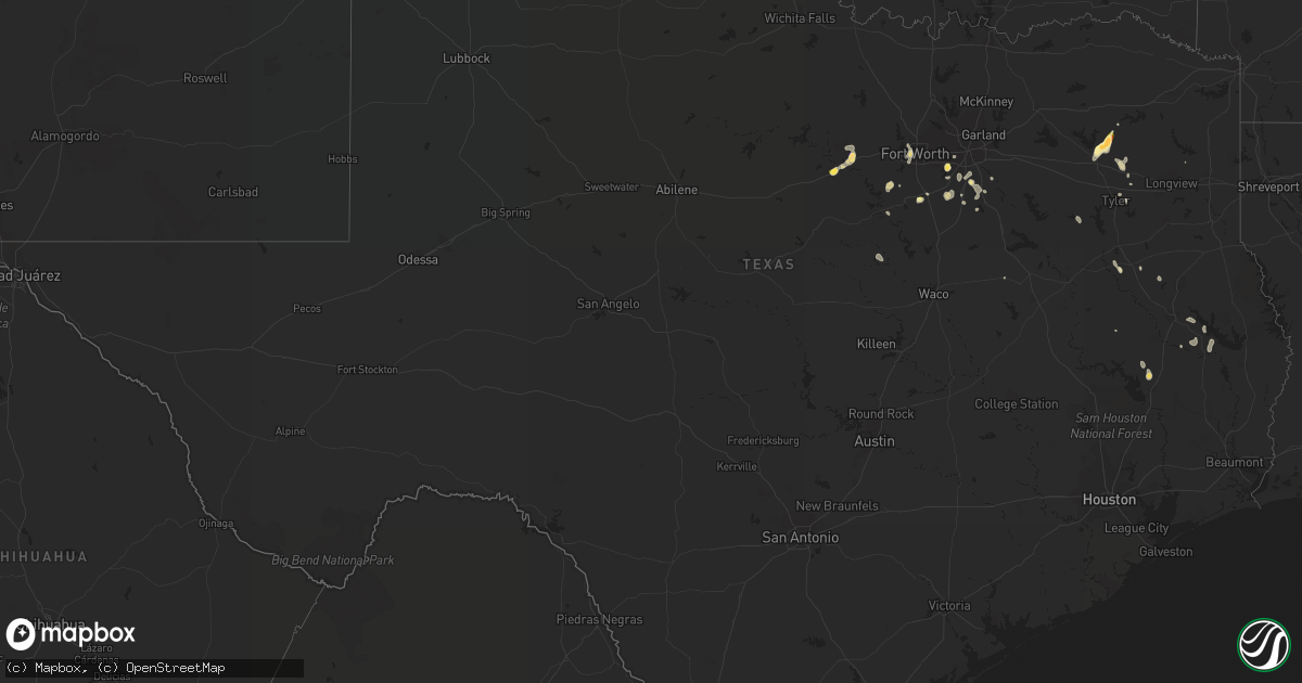
Hail Map in Texas on August 17, 2022
Get this storm
August 17 map
$229
one time, instant access
Download today. No call, no setup
Keep the $229
Bought the map and want the full workflow? Apply the entire $229 to a subscription within 7 days. None of it is wasted.
Every map, not just this one
This buys you this map. Subscription and you get every map we run, in the markets you choose from a few cities to whole states to nationwide. Plus real-time alerts the moment a storm fires.
Contact data
Name, contact info, occupancy, even credit band for addresses in the footprint. You go from where it hit to who to call.
Become the source they trust
Unlimited branding weather history reports on demand. You already have the documented answer ready for the property owner, and you are the one who showed up with it.
Property data and RoofTrace estimates
Pull up any address you have got, its value and the exact code rules for that jurisdiction, straight from One Click Code. Then RoofTrace estimates the squares, pitch, and roof value, priced the way you price.
Storm reports in Texas
Texas
| Date | Description |
|---|---|
| 08/17/20226:42 PM CDT | Gust estimated up to 40 mph blew over greenhouse and large limbs down. |
| 08/17/20226:42 PM CDT | Hail dimes to quarter size. |
| 08/17/20226:24 PM CDT | 1nw castolon bbnp. |
| 08/17/20226:12 PM CDT | Large tree down in tolar. |
| 08/17/20226:12 PM CDT | Corrects previous tstm wnd dmg report from tolar. Large tree limbs and trunks were snapped... And several large trees were uprooted in tolar. Damage to structures... In |
| 08/17/20226:08 PM CDT | Mesonet station 123 1nw castolon... Bbnp big bend np/brewster. |
| 08/17/20226:00 PM CDT | Delayed report. A large tree was uprooted and a small shed was overturned in west. Most damage was reported along reagan street. |
| 08/17/20225:44 PM CDT | 1 inch hail reported quitman. |
| 08/17/20225:44 PM CDT | A local report indicates 60 MPH wind near QUITMAN |
| 08/17/20225:35 PM CDT | Corrects previous hail report from 7 ssw winnsboro. Fm 14 and hwy 37 sw of winnsboro. |
| 08/17/20225:30 PM CDT | Fm 14 and hwy 37 sw of winnsboro. |
| 08/17/20225:12 PM CDT | 18 wheeler box trailer flipped on hwy 14 and cr 983. Large tree branches down. |
| 08/17/20223:50 AM CDT | At 849 PM CDT, a severe thunderstorm was located over Cedar Hill State Park, or near Grand Prairie, and is nearly stationary. HAZARD...60 mph wind gusts and quarter size hail. SOURCE...Radar indicated. IMPACT...Hail damage to vehicles is expected. Expect wind damage to roofs, siding, and trees. Locations impacted include... Dallas, Arlington, Grand Prairie, Mansfield, Desoto, Cedar Hill, Duncanville, Lancaster, Glenn Heights, Cockrell Hill, Ovilla and Cedar Hill State Park.This includes the following highways... Interstate 35E between mile markers 412 and 425. Interstate 20 between mile markers 450 and 469. |
| 08/17/20223:44 AM CDT | At 844 PM CDT, a severe thunderstorm was located 8 miles northwest of Lipan, or 15 miles south of Mineral Wells, moving southwest at 10 mph. HAZARD...60 mph wind gusts and quarter size hail. SOURCE...Radar indicated. IMPACT...Hail damage to vehicles is expected. Expect wind damage to roofs, siding, and trees. Locations impacted include... Gordon.This includes Interstate 20 between mile markers 368 and 389. |
| 08/17/20222:45 AM CDT | At 745 PM CDT, severe thunderstorms were located along a line extending from 11 miles southeast of Etoile to 8 miles north of Chester, moving southeast at 15 mph. HAZARD...60 mph wind gusts and quarter size hail. SOURCE...Radar indicated. IMPACT...Hail damage to vehicles is expected. Expect wind damage to roofs, siding, and trees. Locations impacted include... Zavalla, Broaddus and Dolan. |
| 08/17/20222:18 AM CDT | At 718 PM CDT, a severe thunderstorm was located near Cool, or 9 miles southeast of Mineral Wells, moving south at 10 mph. HAZARD...60 mph wind gusts and quarter size hail. SOURCE...Radar indicated. IMPACT...Hail damage to vehicles is expected. Expect wind damage to roofs, siding, and trees. Locations impacted include... Weatherford, Cool and Millsap. This includes Interstate 20 between mile markers 390 and 405. |
| 08/17/20222:07 AM CDT | At 706 PM CDT, a severe thunderstorm was located near Lajitas, moving northwest at 10 mph. HAZARD...60 mph wind gusts and quarter size hail. SOURCE...Radar indicated. IMPACT...Hail damage to vehicles is expected. Expect wind damage to roofs, siding, and trees. Locations impacted include... Lajitas and Barton Warnock Environmental Educational Center. |
| 08/17/20221:39 AM CDT | At 638 PM CDT, a severe thunderstorm was located over Hawkins, or 14 miles west of Gladewater, moving southeast at 20 mph. HAZARD...60 mph wind gusts and quarter size hail. SOURCE...Radar indicated. IMPACT...Hail damage to vehicles is expected. Expect wind damage to roofs, siding, and trees. Locations impacted include... Big Sandy, Hawkins, Winona and Red Springs. |
| 08/17/20221:25 AM CDT | At 625 PM CDT, a severe thunderstorm was located over Castolon, or 18 miles east of Lajitas, and is nearly stationary. HAZARD...60 mph wind gusts and quarter size hail. SOURCE...Radar indicated. IMPACT...Hail damage to vehicles is expected. Expect wind damage to roofs, siding, and trees. Locations impacted include... Castolon and Study Butte. |
| 08/17/202212:26 AM CDT | At 525 PM CDT, a severe thunderstorm was located near Pleasant Grove, or 7 miles south of Winnsboro, moving southwest at 20 mph. HAZARD...60 mph wind gusts and quarter size hail. SOURCE...Radar indicated. IMPACT...Hail damage to vehicles is expected. Expect wind damage to roofs, siding, and trees. Locations impacted include... Mineola, Lindale, Quitman, Pleasant Grove, Hainesville and Hoard. |
| 08/16/202211:40 PM CDT | At 439 PM CDT, severe thunderstorms were located along a line extending from near Trawick to near Maydelle, moving southeast at 15 mph. HAZARD...60 mph wind gusts and quarter size hail. SOURCE...Radar indicated. IMPACT...Hail damage to vehicles is expected. Expect wind damage to roofs, siding, and trees. Locations impacted include... Nacogdoches, Rusk, Alto, Morrill, Sacul, Forest, Douglass, Trawick, Cushing, Appleby, Linwood, Lilbert and Looneyville. |
| 08/16/20229:15 PM CDT | Delayed report. An 18 wheeler was rolled over at a truck stop... And a fireworks stand nearby was blown over. Report was received via social media. |
| 08/16/20228:55 PM CDT | At 154 PM CDT, a severe thunderstorm was located 10 miles north of Logansport, or 14 miles west of Mansfield, moving southeast at 15 mph. HAZARD...60 mph wind gusts. SOURCE...Radar indicated. IMPACT...Expect damage to roofs, siding, and trees. Locations impacted include... Mansfield, Logansport, South Mansfield, Keachi, Grand Cane, Longstreet, Stanley and Keat Chie. |
| 08/16/20228:34 PM CDT | At 134 PM CDT, a severe thunderstorm was located near Marshall, moving southeast at 15 mph. HAZARD...60 mph wind gusts. SOURCE...Radar indicated. IMPACT...Expect damage to roofs, siding, and trees. Locations impacted include... Marshall, Scottsville and Nesbitt. |
| 08/16/20228:00 PM CDT | Delayed report. Downed trees and miscellaneous damage to trailer homes were reported on curtis ray drive in midlothian. Time estimated via radar. |
| 08/16/20227:55 PM CDT | Delayed report. Sheet metal and portions of the wooden patio structure were ripped off the side and roof of a house in palmer. The retractable door of the metal outbuil |
All States Impacted by Hail Map on August 17, 2022
Cities Impacted by Hail Map on August 17, 2022
- Williston, ND
- Grenora, ND
- Edgemont, SD
- Akron, NY
- Corfu, NY
- Towner, ND
- Isanti, MN
- Northome, MN
- Voltaire, ND
- Livonia, NY
- Fullerton, ND
- Squaw Lake, MN
- Penn Yan, NY
- Dundee, NY
- Dateland, AZ
- Buckeye, AZ
- Gila Bend, AZ
- Bradford, PA
- Waxahachie, TX
- Wright, MN
- Cromwell, MN
- Minot, ND
- Orange City, FL
- Meridian, TX
- Clifton, TX
- Moscow, TX
- Oral, SD
- Hot Springs, SD
- Buffalo Gap, SD
- Oelrichs, SD
- Fort Worth, TX
- Ajo, AZ
- Cleburne, TX
- Alvarado, TX
- Bell, FL
- Streeter, ND
- Ferris, TX
- Tyler, TX
- Andalusia, AL
- Wing, AL
- Daphne, AL
- Mobile, AL
- Ocala, FL
- Larue, TX
- Randolph, NY
- Stanley, NY
- Huntington, TX
- Grygla, MN
- Waterloo, NY
- Kettle River, MN
- Rush, CO
- Cambridge, MN
- Calvin, ND
- Rocklake, ND
- Munich, ND
- Egeland, ND
- Rugby, ND
- Wellsville, NY
- Rosemount, MN
- Inver Grove Heights, MN
- Newport, MN
- South Saint Paul, MN
- Farmington, MN
- Saint Paul, MN
- Whitesville, NY
- Rexville, NY
- Andover, NY
- Millsap, TX
- Weatherford, TX
- Santo, TX
- Vancleave, MS
- Esmond, ND
- Sturgeon Lake, MN
- Summerfield, FL
- Belleview, FL
- Barnum, MN
- Dagmar, MT
- Froid, MT
- Bainville, MT
- Crockett, TX
- Kennard, TX
- Belle Fourche, SD
- Conchas Dam, NM
- Avoca, NY
- Bath, NY
- Ennis, TX
- Palmer, TX
- Jena, LA
- Heidelberg, MS
- Vossburg, MS
- Branford, FL
- Alden, NY
- Lancaster, NY
- Batavia, NY
- Alexander, NY
- Mount Joy, PA
- Manheim, PA
- Kaycee, WY
- Cave Creek, AZ
- Dry Prong, LA
- Colfax, LA
- Bentley, LA
- Rusk, TX
- Godley, TX
- Joshua, TX
- Westby, MT
- Lead, SD
- Harleton, TX
- Mineola, TX
- Winnsboro, TX
- Quitman, TX
- Lufkin, TX
- Jacksonville, TX
- Crawford, NE
- Whitney, NE
- Grandy, MN
- Stanchfield, MN
- Union Church, MS
- McCall Creek, MS
- Douglass, TX
- Cushing, TX
- Grand Cane, LA
- Trenton, FL
- Saint Johns, FL
- Saint Augustine, FL
- Steele, ND
- Kintyre, ND
- Napoleon, ND
- Alzada, MT
- Culbertson, MT
- Dunseith, ND
- Mcgregor, MN
- Tamarack, MN
- Carrabelle, FL
- Jacksonville, FL
- Moose Lake, MN
- Spearfish, SD
- Saint Onge, SD
- Hill City, SD
- Custer, SD
- Grand Prairie, TX
- Cedar Hill, TX
- Dallas, TX
- Braddock, ND
- Bisbee, ND
- Austin, PA
- Frisco City, AL
- Atmore, AL
- Fairview, MT
- Wibaux, MT
- Pringle, SD
- Desoto, TX
- Red Oak, TX
- Hawkins, TX
- Tappen, ND
- Midlothian, TX
- Scroggins, TX
- Venus, TX
- Sells, AZ
- Livingston, TX
- Uriah, AL
- Winona, TX
- Clarence, NY
- Sacramento, PA
- Lykens, PA
- Klingerstown, PA
- Watford City, ND
- Medina, ND
- Mexia, TX
- Moss Point, MS
- Clayton, LA
- Oil City, LA
- Mooringsport, LA
- Lancaster, TX
- Mayo, FL
- Braham, MN
- Grasston, MN
- Belcourt, ND
- Geneva, NY
- Zavalla, TX
- Prattsburgh, NY
- Cloquet, MN
- Jasper, TX
- Theodore, AL
- Grand Bay, AL
- Marsland, NE
- Mylo, ND
- Rolette, ND
- Wolf Creek, OR
- Palatka, FL
- Kulm, ND
- Wirt, MN
- Sawyer, MN
- Eight Mile, AL
- Killdeer, ND
- Antelope, MT
- Plentywood, MT
- Reserve, MT
- Medicine Lake, MT
- Grandview, TX
- Sturgis, SD
- Piedmont, SD
- Hemingford, NE
- Silverhill, AL
- Natchez, MS
- Fayette, MS
- Niceville, FL
- Freeport, FL


