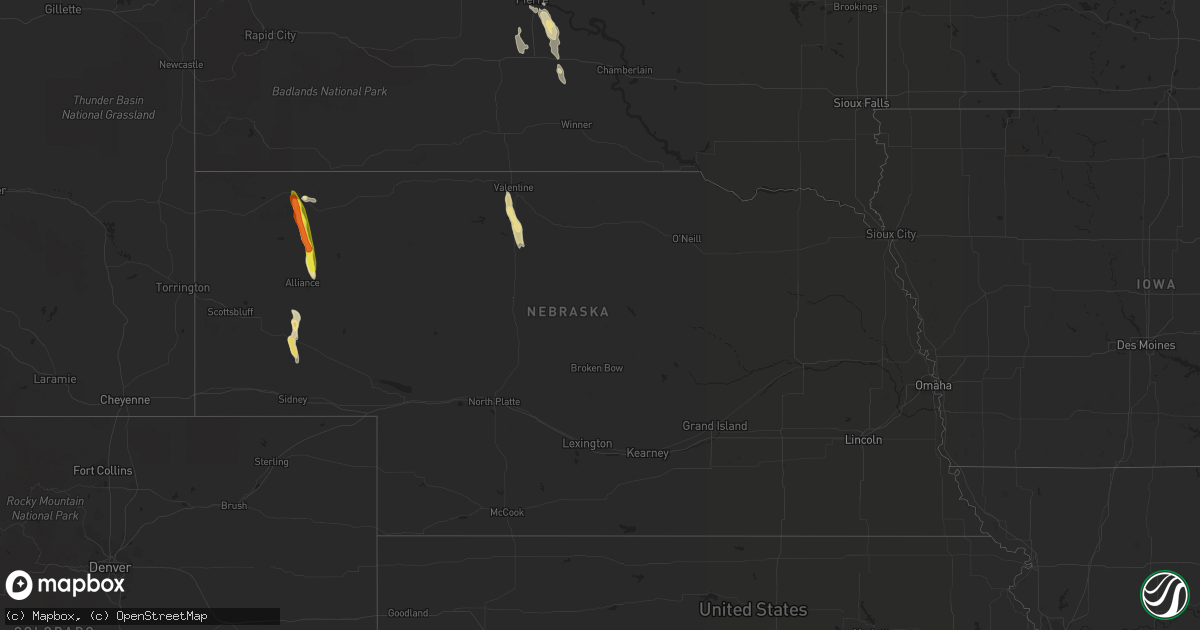
Hail Map in Nebraska on August 17, 2020
Get this storm
August 17 map
$229
one time, instant access
Download today. No call, no setup
Keep the $229
Bought the map and want the full workflow? Apply the entire $229 to a subscription within 7 days. None of it is wasted.
Every map, not just this one
This buys you this map. Subscription and you get every map we run, in the markets you choose from a few cities to whole states to nationwide. Plus real-time alerts the moment a storm fires.
Contact data
Name, contact info, occupancy, even credit band for addresses in the footprint. You go from where it hit to who to call.
Become the source they trust
Unlimited branding weather history reports on demand. You already have the documented answer ready for the property owner, and you are the one who showed up with it.
Property data and RoofTrace estimates
Pull up any address you have got, its value and the exact code rules for that jurisdiction, straight from One Click Code. Then RoofTrace estimates the squares, pitch, and roof value, priced the way you price.
Storm reports in Nebraska
Nebraska
| Date | Description |
|---|---|
| 08/17/20206:24 PM CDT | A local report indicates 1.00 inch wind near 5 SE CHADRON |
| 08/17/20205:40 PM CDT | Chadrad radio reporting power outages to 450 customers from nebraska public power district in southwest part of chadron. |
| 08/17/20205:35 PM CDT | Corrects previous hail report from 5 se chadron. |
| 08/17/20205:15 PM CDT | Public reports estimated winds of 60mph and hail up to the size of ping pongs. Damage to property crop also noted. |
| 08/17/20201:00 AM CDT | At 600 PM MDT, a severe thunderstorm was located 12 miles northeast of Northport, or 21 miles south of Alliance, moving southeast at 25 mph. HAZARD...60 mph wind gusts and quarter size hail. SOURCE...Radar indicated. IMPACT...Hail damage to vehicles is expected. Expect wind damage to roofs, siding, and trees. Locations impacted include... Broadwater. |
| 08/17/202012:35 AM CDT | At 535 PM MDT, a severe thunderstorm was located 13 miles north of Wild Horse Butte, or 17 miles south of Hay Springs, moving southeast at 20 mph. HAZARD...Ping pong ball size hail and 60 mph wind gusts. SOURCE...Radar indicated. IMPACT...People and animals outdoors will be injured. Expect hail damage to roofs, siding, windows, and vehicles. Expect wind damage to roofs, siding, and trees. Locations impacted include... Wild Horse Butte. |
| 08/17/202012:10 AM CDT | At 510 PM MDT, a severe thunderstorm was located 8 miles southwest of Hay Springs, moving southeast at 25 mph. HAZARD...Two inch hail and 60 mph wind gusts. SOURCE...Radar indicated. IMPACT...People and animals outdoors will be injured. Expect hail damage to roofs, siding, windows, and vehicles. Expect wind damage to roofs, siding, and trees. This severe thunderstorm will remain over mainly rural areas of southeastern Dawes County. |
| 08/16/202011:38 PM CDT | At 437 PM MDT, a severe thunderstorm was located near Red Cloud Campground, or 9 miles west of Hay Springs, moving southeast at 25 mph. HAZARD...Golf ball size hail and 60 mph wind gusts. SOURCE...Radar indicated. IMPACT...People and animals outdoors will be injured. Expect hail damage to roofs, siding, windows, and vehicles. Expect wind damage to roofs, siding, and trees. Locations impacted include... Chadron, Red Cloud Campground, Chadron Campground and Chadron St Park. |
| 08/16/202011:13 PM CDT | At 413 PM MDT, a severe thunderstorm was located 9 miles southeast of Chadron, moving southeast at 30 mph. HAZARD...Ping pong ball size hail and 60 mph wind gusts. SOURCE...Radar indicated. IMPACT...People and animals outdoors will be injured. Expect hail damage to roofs, siding, windows, and vehicles. Expect wind damage to roofs, siding, and trees. Locations impacted include... Chadron. |
All States Impacted by Hail Map on August 17, 2020
Cities Impacted by Hail Map on August 17, 2020
- Commerce, GA
- Homer, GA
- Waurika, OK
- Hastings, OK
- Honesdale, PA
- Equinunk, PA
- Pleasant Mount, PA
- Stuart, FL
- Palm Coast, FL
- Bunnell, FL
- Valentine, NE
- Melbourne Beach, FL
- Agar, SD
- Pierre, SD
- Eagle Butte, SD
- Onida, SD
- Randlett, OK
- Angora, NE
- Bridgeport, NE
- Belle Glade, FL
- Alliance, NE
- Geneva, FL
- Wilmer, AL
- Mcdonough, GA
- Fort Pierre, SD
- Presho, SD
- Maupin, OR
- Warm Springs, OR
- Jefferson, GA
- Hay Springs, NE
- Chadron, NE
- Alamogordo, NM
- Tunkhannock, PA
- Broadwater, NE
- Crooksville, OH
- Roseville, OH
- Blue Rock, OH
- Mcconnelsville, OH
- Lucedale, MS
- Shelby, NC
- Kings Mountain, NC
- Cherryville, NC
- Calliham, TX
- Elkton, FL
- Thedford, NE
- Hemingford, NE
- Fort Yates, ND
- Washoe Valley, NV
- Meshoppen, PA
- Mehoopany, PA
- Dunnellon, FL
- Titusville, FL
- Clarks Summit, PA
- Dalton, PA
- Reno, NV
- Okeechobee, FL
- Mountain Top, PA
- Blunt, SD
- Loxahatchee, FL
- Lower Brule, SD
- Perry, FL
- Whitsett, TX
- Marietta, OK
- Prescott, AZ
- Three Rivers, TX
- Hialeah, FL
- Fort Pierce, FL
- Draper, SD
- Wind Gap, PA
- Bath, PA
- Laceyville, PA
- Eunice, NM
- Cloudcroft, NM
- Wichita Falls, TX
- Sells, AZ
- Oswego, NY
- Madras, OR
- Citronelle, AL
- Culver, OR
- Lake Harmony, PA
- Genoa, NV
- Prattville, AL
- Pollock, SD
- Rocksprings, TX
- Windermere, FL
- Winter Garden, FL
- Malta, OH


