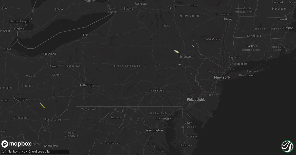
Hail Map in Pennsylvania on August 17, 2020
Get this storm
August 17 map
$229
one time, instant access
Download today. No call, no setup
Keep the $229
Bought the map and want the full workflow? Apply the entire $229 to a subscription within 7 days. None of it is wasted.
Every map, not just this one
This buys you this map. Subscription and you get every map we run, in the markets you choose from a few cities to whole states to nationwide. Plus real-time alerts the moment a storm fires.
Contact data
Name, contact info, occupancy, even credit band for addresses in the footprint. You go from where it hit to who to call.
Become the source they trust
Unlimited branding weather history reports on demand. You already have the documented answer ready for the property owner, and you are the one who showed up with it.
Property data and RoofTrace estimates
Pull up any address you have got, its value and the exact code rules for that jurisdiction, straight from One Click Code. Then RoofTrace estimates the squares, pitch, and roof value, priced the way you price.
Storm reports in Pennsylvania
Pennsylvania
| Date | Description |
|---|---|
| 08/17/20206:59 AM CDT | At 1159 PM EDT, a severe thunderstorm was located over Blakeslee, or 13 miles west of Mount Pocono, moving east at 25 mph. HAZARD...60 mph wind gusts and quarter size hail. SOURCE...Radar indicated. IMPACT...Minor damage to vehicles is possible. Wind damage to roofs, siding, trees, and power lines is possible. Locations impacted include... Mount Pocono, Tobyhanna, Brodheadsville, Pocono Pines, Gilbert, Pocono Raceway, Lake Harmony, Skytop, Tannersville, Mountainhome, Rossland, Long Pond, Albrightsville, Kresgeville, Sun Valley, Arrowhead Lake, Jonas, Meckesville, Reeders and McMichael.This includes the following highways... Northeast Extension between mile markers 83 and 97. Interstate 80 in Pennsylvania between mile markers 277 and 304. Interstate 380 in Pennsylvania between mile markers 0 and 13. |
| 08/17/20206:57 AM CDT | At 1157 PM EDT, a severe thunderstorm was located over Rutledgedale, or 10 miles northeast of Honesdale, moving southeast at 25 mph. HAZARD...60 mph wind gusts and quarter size hail. SOURCE...Radar indicated. IMPACT...Hail damage to vehicles is expected. Expect wind damage to roofs, siding, and trees. Locations impacted include... Bethel, Damascus, Callicoon, Tusten, Cochecton, Narrowsburg, Mongaup Valley, Smallwood, White Lake and Rutledgedale. |
| 08/17/20206:39 AM CDT | At 1139 PM EDT, a severe thunderstorm was located over Penobscot, or 7 miles south of Wilkes-Barre, moving southeast at 25 mph. HAZARD...60 mph wind gusts and quarter size hail. SOURCE...Radar indicated. IMPACT...Hail damage to vehicles is expected. Expect wind damage to roofs, siding, and trees. Locations impacted include... Wilkes-Barre, Ashley, Bear Creek, White Haven, Preston, Sugar Notch, Nuangola, Warrior Run, Laurel Run and Penn Lake Park. |
| 08/17/20206:37 AM CDT | At 1137 PM EDT, a severe thunderstorm was located near Rutledgedale, or 12 miles north of Honesdale, moving east at 35 mph. HAZARD...60 mph wind gusts and quarter size hail. SOURCE...Radar indicated. IMPACT...Hail damage to vehicles is expected. Expect wind damage to roofs, siding, and trees. Locations impacted include... Bethel, Damascus, Callicoon, Cochecton, Jeffersonville, Narrowsburg, Stalker, Equinunk, Rutledgedale and Hankins. |
| 08/17/20205:39 AM CDT | At 1039 PM EDT, a severe thunderstorm was located over Osterhout, or near Tunkhannock, moving southeast at 25 mph. HAZARD...60 mph wind gusts and nickel size hail. SOURCE...Radar indicated. IMPACT...Expect damage to roofs, siding, and trees. Locations impacted include... Scranton, Falls, Dunmore, Old Forge, Archbald, Blakely, Taylor, Dickson City, Moosic and Olyphant. |
| 08/17/202012:17 AM CDT | Downed trees and wires near hartzell ferry road. Time estimated from radar. |
| 08/17/202012:10 AM CDT | Trees and wires down in lower saucon twp. Time estimated by radar. |
| 08/17/202012:00 AM CDT | Trees and wires down in bethlehem twp. Time estimated by radar. |
| 08/16/202011:59 PM CDT | Downed trees and wires near twilight trail. Time estimated from radar. |
| 08/16/202011:48 PM CDT | Downed trees and power lines on paradise trail near wooddale road. Time estimated from radar. |
| 08/16/202011:44 PM CDT | Downed tree blocking reish road in stroud township. Time estimated from radar. |
| 08/16/202011:34 PM CDT | Downed tree on camelback road near resort drive in tannersville. Time estimated from radar. |
| 08/16/202011:33 PM CDT | Downed trees and wires near mountain spring lake. Time estimated from radar. |
| 08/16/202011:22 PM CDT | Downed tree and wires near steckel road in jonas. Time estimated from radar. |
| 08/16/202011:20 PM CDT | Downed tree on timber lane in tobyhanna twp. Time estimated from radar. |
| 08/16/202011:16 PM CDT | Tree down on roadway in pocono pines. Time estimated by radar. |
| 08/16/202011:13 PM CDT | Downed tree on stoney hollow road in tobyhanna twp. Time estimated from radar. |
| 08/16/202011:11 PM CDT | Downed tree on locust ridge road near spur road in tobyhanna twp. Time estimated from radar. |
| 08/16/20209:30 PM CDT | Tree fell down in the yard of a house. Time estimated from radar. |
| 08/16/20209:30 PM CDT | Large pine tree fell onto a garage causing significant damage. Time is estimated by radar. |
| 08/16/20208:35 PM CDT | Tree down across roadway near route 6 and route 409. Time estimated from radar. |
All States Impacted by Hail Map on August 17, 2020
Cities Impacted by Hail Map on August 17, 2020
- Commerce, GA
- Homer, GA
- Waurika, OK
- Hastings, OK
- Honesdale, PA
- Equinunk, PA
- Pleasant Mount, PA
- Stuart, FL
- Palm Coast, FL
- Bunnell, FL
- Valentine, NE
- Melbourne Beach, FL
- Agar, SD
- Pierre, SD
- Eagle Butte, SD
- Onida, SD
- Randlett, OK
- Angora, NE
- Bridgeport, NE
- Belle Glade, FL
- Alliance, NE
- Geneva, FL
- Wilmer, AL
- Mcdonough, GA
- Fort Pierre, SD
- Presho, SD
- Maupin, OR
- Warm Springs, OR
- Jefferson, GA
- Hay Springs, NE
- Chadron, NE
- Alamogordo, NM
- Tunkhannock, PA
- Broadwater, NE
- Crooksville, OH
- Roseville, OH
- Blue Rock, OH
- Mcconnelsville, OH
- Lucedale, MS
- Shelby, NC
- Kings Mountain, NC
- Cherryville, NC
- Calliham, TX
- Elkton, FL
- Thedford, NE
- Hemingford, NE
- Fort Yates, ND
- Washoe Valley, NV
- Meshoppen, PA
- Mehoopany, PA
- Dunnellon, FL
- Titusville, FL
- Clarks Summit, PA
- Dalton, PA
- Reno, NV
- Okeechobee, FL
- Mountain Top, PA
- Blunt, SD
- Loxahatchee, FL
- Lower Brule, SD
- Perry, FL
- Whitsett, TX
- Marietta, OK
- Prescott, AZ
- Three Rivers, TX
- Hialeah, FL
- Fort Pierce, FL
- Draper, SD
- Wind Gap, PA
- Bath, PA
- Laceyville, PA
- Eunice, NM
- Cloudcroft, NM
- Wichita Falls, TX
- Sells, AZ
- Oswego, NY
- Madras, OR
- Citronelle, AL
- Culver, OR
- Lake Harmony, PA
- Genoa, NV
- Prattville, AL
- Pollock, SD
- Rocksprings, TX
- Windermere, FL
- Winter Garden, FL
- Malta, OH


