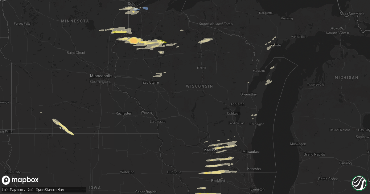
Hail Map in Wisconsin on August 16, 2023
Get this storm
August 16 map
$229
one time, instant access
Download today. No call, no setup
Keep the $229
Bought the map and want the full workflow? Apply the entire $229 to a subscription within 7 days. None of it is wasted.
Every map, not just this one
This buys you this map. Subscription and you get every map we run, in the markets you choose from a few cities to whole states to nationwide. Plus real-time alerts the moment a storm fires.
Contact data
Name, contact info, occupancy, even credit band for addresses in the footprint. You go from where it hit to who to call.
Become the source they trust
Unlimited branding weather history reports on demand. You already have the documented answer ready for the property owner, and you are the one who showed up with it.
Property data and RoofTrace estimates
Pull up any address you have got, its value and the exact code rules for that jurisdiction, straight from One Click Code. Then RoofTrace estimates the squares, pitch, and roof value, priced the way you price.
Storm reports in Wisconsin
Wisconsin
| Date | Description |
|---|---|
| 08/16/20236:40 PM CDT | Report via social media with photo. Multiple mature poplar trees snapped 10 to 20 feet off ground. Time estimated from radar. |
| 08/16/20236:40 PM CDT | Report from mping: trees uprooted or snapped; roof blown off. Time estimated from radar. |
| 08/16/20236:36 PM CDT | Report of tree down on powerline. Time estimated from radar. |
| 08/16/20236:36 PM CDT | 12-13 inch tree snapped at the base. |
| 08/16/20236:30 PM CDT | Fence panels were broken and blown into a window due to thunderstorm winds. Location approximate. Report received via facebook. Time estimated by radar. |
| 08/15/20239:29 PM CDT | Corrects previous tstm wnd dmg report from 4 ene stone lake. This corrects the time that was previously incorrect. A branch from a tree was knocked down due to thunders |
| 08/15/20239:00 PM CDT | Tree down across post avenue. Time estimated from radar. |
| 08/15/20238:48 PM CDT | Photo with hail next to a quarter. |
| 08/15/20238:41 PM CDT | Tree down across highway k. Time estimated from radar. |
| 08/15/20238:36 PM CDT | Report from mping: tennis ball |
| 08/15/20238:36 PM CDT | Tree down blocking three quarters of roadway on county highway e. Time estimated from radar. |
| 08/15/20238:36 PM CDT | Tree down partially across road. Time estimated from radar. |
| 08/15/20238:36 PM CDT | Large dead pine across roadway with bumper in middle of road from car having hit it. Time estimated from radar. |
| 08/15/20238:28 PM CDT | 4 to 5 small to medium trees down on greenwood lane. Time estimated from radar. |
| 08/15/20238:15 PM CDT | Report from mping: quarter |
| 08/15/20238:00 PM CDT | Tree fell over the road on county road h north of highway 70 near hertel. Location approximate. |
| 08/15/20237:42 PM CDT | Numerous trees 8 to 12 inches in diameter down and powerline down. Time estimated from radar. |
| 08/15/20237:15 PM CDT | Pictures of three large and healthy trees uprooted and possibly snapped. A trailer was blown over on its side. Several pictures shared via facebook. Location approximat |
All States Impacted by Hail Map on August 16, 2023
Cities Impacted by Hail Map on August 16, 2023
- Chadbourn, NC
- Zolfo Springs, FL
- Odem, TX
- Sanderson, FL
- Boston, GA
- Thomasville, GA
- Whigham, GA
- Lithia, FL
- Millwood, GA
- Nicholls, GA
- Waycross, GA
- Cairo, GA
- Chinquapin, NC
- Richlands, NC
- Sinton, TX
- Mathis, TX
- Titusville, FL
- Cerro Gordo, NC
- Elkton, FL
- Whiteville, NC
- Saint Cloud, FL
- Manor, GA
- Flagstaff, AZ
- Clarendon, NC
- Sebring, FL
- Alachua, FL
- High Springs, FL
- South Range, WI
- Poplar, WI
- Maple, WI
- Brule, WI
- Superior, WI
- Hinckley, MN
- Sandstone, MN
- Webster, WI
- Danbury, WI
- Trimont, MN
- Sherburn, MN
- Welcome, MN
- Spooner, WI
- Stone Lake, WI
- Sarona, WI
- Springbrook, WI
- Ojibwa, WI
- Winter, WI
- Fairmont, MN
- Granada, MN
- Ledyard, IA
- Elmore, MN
- Swea City, IA
- Birchwood, WI
- Couderay, WI
- Sandia, TX
- Mora, MN
- Isle, MN
- Varnville, SC
- Carlton, MN
- Duluth, MN
- Esko, MN
- Wrenshall, MN
- Askov, MN
- Bruno, MN
- Finlayson, MN
- Belhaven, NC
- Santee, SC
- Concepcion, TX
- Mountain Lake, MN
- Baxley, GA
- Gordon, WI
- Foxboro, WI
- Barnum, MN
- Happy Jack, AZ
- Sedona, AZ
- Hertel, WI
- Siren, WI
- Shell Lake, WI
- Grantsburg, WI
- Westbrook, MN
- Alpha, MN
- Jackson, MN
- Bingham Lake, MN
- Odin, MN
- Robstown, TX
- Alma, GA
- Mershon, GA
- Jesup, GA
- Cadott, WI
- Ladysmith, WI
- Blue Earth, MN
- Ceylon, MN
- Windom, MN
- Stanley, WI
- Boyd, WI
- Exeland, WI
- Radisson, WI
- Trego, WI
- Eagle River, WI
- Lake Tomahawk, WI
- Woodruff, WI
- Hayward, WI
- Abrams, WI
- Phillips, WI
- Park Falls, WI
- Butternut, WI
- Minocqua, WI
- Hazelhurst, WI
- Saint Germain, WI
- Chippewa Falls, WI
- Cornell, WI
- Jim Falls, WI
- New Boston, IL
- Joy, IL
- Durand, IL
- Rockton, IL
- South Beloit, IL
- Clinton, WI
- Roscoe, IL
- Aledo, IL
- Viola, IL
- Janesville, WI
- Brodhead, WI
- Orfordville, WI
- Deerfield, WI
- Wilson, MI
- Bark River, MI
- Escanaba, MI
- Sturgeon Bay, WI
- Cambridge, WI
- Lake Mills, WI
- Jefferson, WI
- Ixonia, WI
- Juneau, WI
- Milton, WI
- Fort Atkinson, WI
- Gladstone, MI
- Lake Geneva, WI
- Oconomowoc, WI
- Watertown, WI
- Marshall, WI
- Waterloo, WI
- Sun Prairie, WI
- Delavan, WI
- Whitewater, WI
- Elkhorn, WI
- Avalon, WI
- Palmyra, WI
- Harvard, IL
- Walworth, WI
- Stoughton, WI
- Cottage Grove, WI
- Columbus, WI
- Waunakee, WI
- Newton, WI
- Cleveland, WI
- Wells, MI
- Johnson Creek, WI
- Valders, WI
- Kiel, WI
- Elkhart Lake, WI
- Caledonia, IL
- Rockford, IL
- Belvidere, IL
- Ashippun, WI
- Neosho, WI
- Lebanon, WI
- Rubicon, WI
- Evansville, WI
- Brooklyn, WI
- Albany, WI
- Edgerton, WI
- Eagle, WI
- Reeseville, WI
- Windsor, WI
- Deforest, WI
- Madison, WI
- Beloit, WI
- Footville, WI
- Rapid River, MI
- Rock, MI
- Egg Harbor, WI
- Rock City, IL
- Dakota, IL
- Davis, IL
- Poplar Grove, IL
- Freeport, IL
- Orangeville, IL
- Fish Creek, WI
- Sister Bay, WI
- Baileys Harbor, WI
- Ephraim, WI
- Monroe, WI
- Sharon, WI
- Capron, IL
- Barronett, WI
- Ohio, IL
- Walnut, IL
- East Moline, IL
- Colona, IL
- Carbon Cliff, IL
- Geneseo, IL
- Silvis, IL
- New Windsor, IL
- Sherrard, IL
- Lynn Center, IL
- Mayville, WI
- Iron Ridge, WI
- Sheffield, IL
- Atkinson, IL
- Mineral, IL
- Annawan, IL
- Loves Park, IL
- Little York, IL
- Alexis, IL
- Seaton, IL
- Sterling, IL
- Burlington, IA
- Morrison, IL
- Franklin Grove, IL
- Chana, IL
- Milledgeville, IL
- Polo, IL
- Rochelle, IL
- Woosung, IL
- Chadwick, IL
- Ashton, IL
- Oregon, IL
- Dixon, IL
- Moline, IL
- Belleville, WI
- Amboy, IL
- Harmon, IL
- Shirland, IL
- Wapello, IA
- Cambridge, IL
- Lanark, IL
- Forreston, IL
- Prophetstown, IL
- Hartford, WI
- Sperry, IA
- Erie, IL
- Juda, WI
- Winslow, IL
- Hebron, IL
- McConnell, IL
- Davis Junction, IL
- Dane, WI
- Lodi, WI
- Columbus Junction, IA
- Darien, WI
- North Henderson, IL
- Hillsdale, IL


