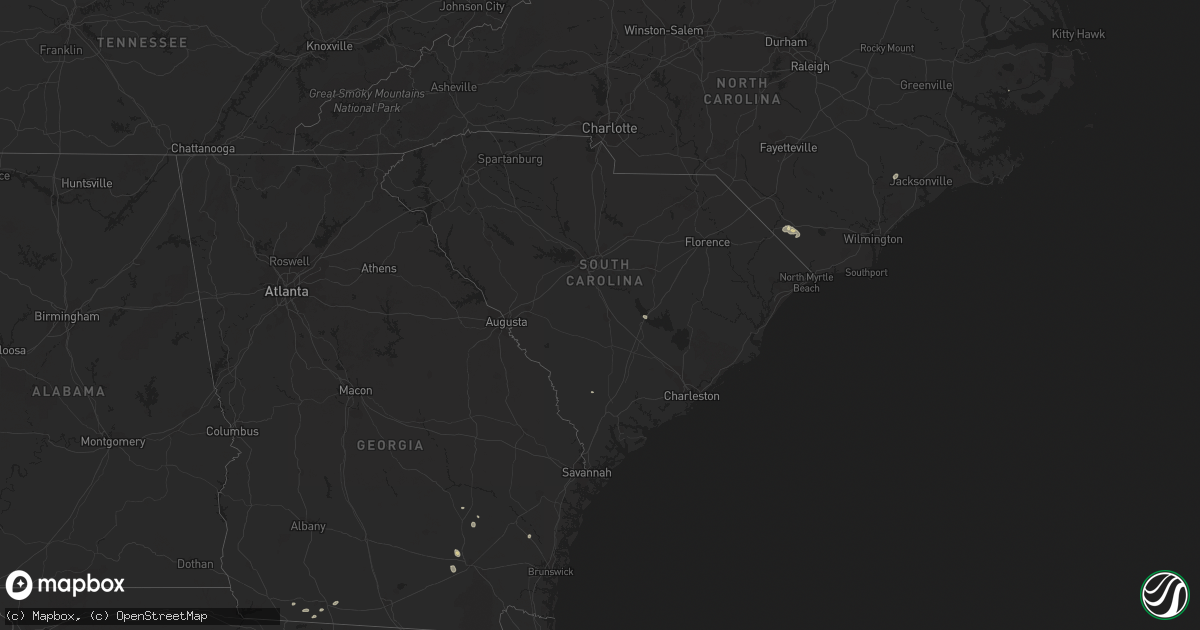
Hail Map in South Carolina on August 16, 2023
Get this storm
August 16 map
$229
one time, instant access
Download today. No call, no setup
Keep the $229
Bought the map and want the full workflow? Apply the entire $229 to a subscription within 7 days. None of it is wasted.
Every map, not just this one
This buys you this map. Subscription and you get every map we run, in the markets you choose from a few cities to whole states to nationwide. Plus real-time alerts the moment a storm fires.
Contact data
Name, contact info, occupancy, even credit band for addresses in the footprint. You go from where it hit to who to call.
Become the source they trust
Unlimited branding weather history reports on demand. You already have the documented answer ready for the property owner, and you are the one who showed up with it.
Property data and RoofTrace estimates
Pull up any address you have got, its value and the exact code rules for that jurisdiction, straight from One Click Code. Then RoofTrace estimates the squares, pitch, and roof value, priced the way you price.
Storm reports in South Carolina
South Carolina
| Date | Description |
|---|---|
| 08/16/20233:09 PM CDT | Santee electric reported a tree on powerlines on dozier mallett rd at mallett rd. Time estimated by radar. |
| 08/16/20232:45 PM CDT | Santee electric reported a tree on powerlines on malibu dr. At hwy 260. Time estimated by radar. |
| 08/16/20232:40 PM CDT | Santee electric coop reported a tree on powerlines on bayview dr. Time estimated by radar. |
| 08/15/20238:48 PM CDT | A beaufort county emergency manager reported a tree down due to thunderstorm outflow near the intersection of harvey road and ivy lane. |
| 08/15/20238:32 PM CDT | A colleton county emergency manager reported a tree down due to thunderstorm outflow near 4000 bonnie doon road. |
| 08/15/20238:32 PM CDT | A beaufort county emergency manager reported a tree down due to thunderstorm outflow along the 100 block of broad river road. |
| 08/15/20237:59 PM CDT | A colleton county emergency manager reported a tree down due to thunderstorm outflow near 7000 bennetts point road. |
| 08/15/20237:56 PM CDT | A colleton county emergency manager reported a tree down due to thunderstorm outflow near 3000 clatty farm road. |
| 08/15/20237:39 PM CDT | A beaufort county emergency manager reported a tree down due to thunderstorm outflow along the 600 block of river road. |
All States Impacted by Hail Map on August 16, 2023
Cities Impacted by Hail Map on August 16, 2023
- Chadbourn, NC
- Zolfo Springs, FL
- Odem, TX
- Sanderson, FL
- Boston, GA
- Thomasville, GA
- Whigham, GA
- Lithia, FL
- Millwood, GA
- Nicholls, GA
- Waycross, GA
- Cairo, GA
- Chinquapin, NC
- Richlands, NC
- Sinton, TX
- Mathis, TX
- Titusville, FL
- Cerro Gordo, NC
- Elkton, FL
- Whiteville, NC
- Saint Cloud, FL
- Manor, GA
- Flagstaff, AZ
- Clarendon, NC
- Sebring, FL
- Alachua, FL
- High Springs, FL
- South Range, WI
- Poplar, WI
- Maple, WI
- Brule, WI
- Superior, WI
- Hinckley, MN
- Sandstone, MN
- Webster, WI
- Danbury, WI
- Trimont, MN
- Sherburn, MN
- Welcome, MN
- Spooner, WI
- Stone Lake, WI
- Sarona, WI
- Springbrook, WI
- Ojibwa, WI
- Winter, WI
- Fairmont, MN
- Granada, MN
- Ledyard, IA
- Elmore, MN
- Swea City, IA
- Birchwood, WI
- Couderay, WI
- Sandia, TX
- Mora, MN
- Isle, MN
- Varnville, SC
- Carlton, MN
- Duluth, MN
- Esko, MN
- Wrenshall, MN
- Askov, MN
- Bruno, MN
- Finlayson, MN
- Belhaven, NC
- Santee, SC
- Concepcion, TX
- Mountain Lake, MN
- Baxley, GA
- Gordon, WI
- Foxboro, WI
- Barnum, MN
- Happy Jack, AZ
- Sedona, AZ
- Hertel, WI
- Siren, WI
- Shell Lake, WI
- Grantsburg, WI
- Westbrook, MN
- Alpha, MN
- Jackson, MN
- Bingham Lake, MN
- Odin, MN
- Robstown, TX
- Alma, GA
- Mershon, GA
- Jesup, GA
- Cadott, WI
- Ladysmith, WI
- Blue Earth, MN
- Ceylon, MN
- Windom, MN
- Stanley, WI
- Boyd, WI
- Exeland, WI
- Radisson, WI
- Trego, WI
- Eagle River, WI
- Lake Tomahawk, WI
- Woodruff, WI
- Hayward, WI
- Abrams, WI
- Phillips, WI
- Park Falls, WI
- Butternut, WI
- Minocqua, WI
- Hazelhurst, WI
- Saint Germain, WI
- Chippewa Falls, WI
- Cornell, WI
- Jim Falls, WI
- New Boston, IL
- Joy, IL
- Durand, IL
- Rockton, IL
- South Beloit, IL
- Clinton, WI
- Roscoe, IL
- Aledo, IL
- Viola, IL
- Janesville, WI
- Brodhead, WI
- Orfordville, WI
- Deerfield, WI
- Wilson, MI
- Bark River, MI
- Escanaba, MI
- Sturgeon Bay, WI
- Cambridge, WI
- Lake Mills, WI
- Jefferson, WI
- Ixonia, WI
- Juneau, WI
- Milton, WI
- Fort Atkinson, WI
- Gladstone, MI
- Lake Geneva, WI
- Oconomowoc, WI
- Watertown, WI
- Marshall, WI
- Waterloo, WI
- Sun Prairie, WI
- Delavan, WI
- Whitewater, WI
- Elkhorn, WI
- Avalon, WI
- Palmyra, WI
- Harvard, IL
- Walworth, WI
- Stoughton, WI
- Cottage Grove, WI
- Columbus, WI
- Waunakee, WI
- Newton, WI
- Cleveland, WI
- Wells, MI
- Johnson Creek, WI
- Valders, WI
- Kiel, WI
- Elkhart Lake, WI
- Caledonia, IL
- Rockford, IL
- Belvidere, IL
- Ashippun, WI
- Neosho, WI
- Lebanon, WI
- Rubicon, WI
- Evansville, WI
- Brooklyn, WI
- Albany, WI
- Edgerton, WI
- Eagle, WI
- Reeseville, WI
- Windsor, WI
- Deforest, WI
- Madison, WI
- Beloit, WI
- Footville, WI
- Rapid River, MI
- Rock, MI
- Egg Harbor, WI
- Rock City, IL
- Dakota, IL
- Davis, IL
- Poplar Grove, IL
- Freeport, IL
- Orangeville, IL
- Fish Creek, WI
- Sister Bay, WI
- Baileys Harbor, WI
- Ephraim, WI
- Monroe, WI
- Sharon, WI
- Capron, IL
- Barronett, WI
- Ohio, IL
- Walnut, IL
- East Moline, IL
- Colona, IL
- Carbon Cliff, IL
- Geneseo, IL
- Silvis, IL
- New Windsor, IL
- Sherrard, IL
- Lynn Center, IL
- Mayville, WI
- Iron Ridge, WI
- Sheffield, IL
- Atkinson, IL
- Mineral, IL
- Annawan, IL
- Loves Park, IL
- Little York, IL
- Alexis, IL
- Seaton, IL
- Sterling, IL
- Burlington, IA
- Morrison, IL
- Franklin Grove, IL
- Chana, IL
- Milledgeville, IL
- Polo, IL
- Rochelle, IL
- Woosung, IL
- Chadwick, IL
- Ashton, IL
- Oregon, IL
- Dixon, IL
- Moline, IL
- Belleville, WI
- Amboy, IL
- Harmon, IL
- Shirland, IL
- Wapello, IA
- Cambridge, IL
- Lanark, IL
- Forreston, IL
- Prophetstown, IL
- Hartford, WI
- Sperry, IA
- Erie, IL
- Juda, WI
- Winslow, IL
- Hebron, IL
- McConnell, IL
- Davis Junction, IL
- Dane, WI
- Lodi, WI
- Columbus Junction, IA
- Darien, WI
- North Henderson, IL
- Hillsdale, IL


