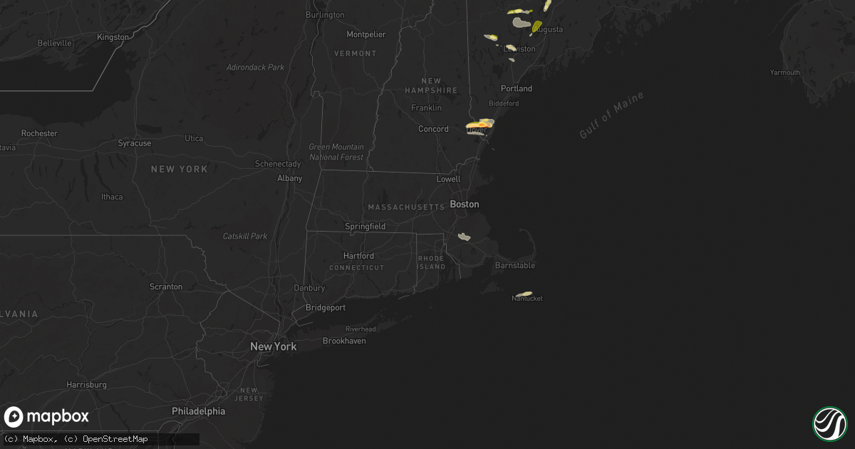
Hail Map in Massachusetts on August 13, 2023
Get this storm
August 13 map
$229
one time, instant access
Download today. No call, no setup
Keep the $229
Bought the map and want the full workflow? Apply the entire $229 to a subscription within 7 days. None of it is wasted.
Every map, not just this one
This buys you this map. Subscription and you get every map we run, in the markets you choose from a few cities to whole states to nationwide. Plus real-time alerts the moment a storm fires.
Contact data
Name, contact info, occupancy, even credit band for addresses in the footprint. You go from where it hit to who to call.
Become the source they trust
Unlimited branding weather history reports on demand. You already have the documented answer ready for the property owner, and you are the one who showed up with it.
Property data and RoofTrace estimates
Pull up any address you have got, its value and the exact code rules for that jurisdiction, straight from One Click Code. Then RoofTrace estimates the squares, pitch, and roof value, priced the way you price.
Storm reports in Massachusetts
Massachusetts
| Date | Description |
|---|---|
| 08/13/20233:55 PM CDT | Tree downed partially blocking part of vernon st in middleborough. Relayed by amateur radio. |
| 08/13/20233:48 PM CDT | Tree down on howard st in south easton. Relayed by amateur radio. |
| 08/13/20233:45 PM CDT | Powerline wires downed in vicinity of broadway in raynham. Relayed by amateur radio. |
| 08/13/20233:20 PM CDT | Powerlines downed on old farm rd in easton. Relayed by amateur radio. |
| 08/13/20233:20 PM CDT | Large tree branch downed on powerlines near prospect st in easton. Relayed by amateur radio. |
| 08/13/20233:20 PM CDT | In south easton... A large pine tree was snapped near its base... Two smaller trees were downed... And power lines were downed at the intersection of olde farm road and |
| 08/13/20233:15 PM CDT | Tree down in vicinity of burt st in norton. Relayed by amateur radio. |
All States Impacted by Hail Map on August 13, 2023
Cities Impacted by Hail Map on August 13, 2023
- Milan, TN
- Atwood, TN
- Mora, MO
- Sedalia, MO
- Friendship, TN
- Halls, TN
- Dyersburg, TN
- Smithton, MO
- Florence, MO
- Ionia, MO
- Cole Camp, MO
- Humboldt, TN
- Greenfield, TN
- Ripley, TN
- Gates, TN
- Barrington, NH
- Rochester, NH
- Berwick, ME
- Dover, NH
- Somersworth, NH
- Rollinsford, NH
- South Berwick, ME
- North Berwick, ME
- Cape Neddick, ME
- Wells, ME
- Bingham, ME
- Kingman, AZ
- Harmony, ME
- Athens, ME
- Guilford, ME
- Jay, ME
- Dixfield, ME
- Canton, ME
- Belgrade, ME
- Oakland, ME
- Smithfield, ME
- Farmington, ME
- Vienna, ME
- Norway, ME
- Dover Foxcroft, ME
- Garland, ME
- Carmel, ME
- Bangor, ME
- Levant, ME
- Ashland City, TN
- Charlotte, TN
- Cumberland Furnace, TN
- Vanleer, TN
- Dickson, TN
- White Bluff, TN
- Chapmansboro, TN
- Nashville, TN
- Pegram, TN
- Joelton, TN
- Whites Creek, TN
- Cunningham, TN
- Cumberland City, TN
- Erin, TN
- Charleston, ME
- Bradford, ME
- Milo, ME
- Winthrop, ME
- Readfield, ME
- Manchester, ME
- Stratford, TX
- Dalhart, TX
- Sunray, TX
- Gruver, TX
- Perryton, TX
- Wheeler, TX
- Mobeetie, TX
- Clarendon, TX
- Briscoe, TX
- Shamrock, TX
- Stinnett, TX
- Lincolnville, KS
- Burdick, KS
- Canadian, TX
- Strong City, KS
- Wilsey, KS
- Booker, TX
- Higgins, TX
- Emporia, KS
- Durham, OK
- Crawford, OK
- Arnett, OK
- Olpe, KS
- Clinton, ME
- Saint Albans, ME
- Monmouth, ME
- Oxford, ME
- Ardmore, TN
- Hedley, TX
- Waterford, ME
- Hope, KS
- Tampa, KS
- Ramona, KS
- Minot, ME
- Mechanic Falls, ME
- Nantucket, MA
- Wayne, ME
- Kents Hill, ME
- Leeds, ME
- Livermore, ME
- Turner, ME
- Livermore Falls, ME
- Buckfield, ME
- Poland, ME
- Auburn, ME
- Kittery, ME
- Beaverton, AL
- Sulligent, AL
- Blue Mountain, MS
- Ripley, MS
- New Portland, ME
- Solon, ME
- Cambridge, ME
- Sangerville, ME
- Eliot, ME
- Madbury, NH
- Durham, NH
- Lee, NH
- Fairfield, ME
- Corinth, ME
- Exeter, ME
- Tishomingo, MS
- Booneville, MS
- Gadsden, AL
- Iuka, MS
- Burnsville, MS
- Tiplersville, MS
- Falkner, MS
- Peru, ME
- Amarillo, TX
- Ashland, MS
- New Albany, MS
- Mclean, TX
- Dexter, ME
- Toney, AL
- Norton, MA
- South Easton, MA
- Raynham, MA
- Taunton, MA
- West Bridgewater, MA
- Bridgewater, MA
- Herington, KS
- Lost Springs, KS
- Ogunquit, ME
- Crossville, AL
- Collinsville, AL
- Lelia Lake, TX
- Pittsburg, NH
- Florence, AL
- Medina, TN
- Ashville, AL
- Pampa, TX
- Dolan Springs, AZ
- Gaylesville, AL
- Kenduskeag, ME
- Stetson, ME
- Hartford, KS
- Burlington, KS
- Tunnel Hill, GA
- Rocky Face, GA
- Dalton, GA
- Kansas City, MO
- Le Roy, KS
- Fort Supply, OK
- Wilmore, KS
- Lake City, KS
- Woodward, OK
- Neosho Falls, KS
- Colony, KS
- Buffalo, OK
- May, OK
- Fargo, OK
- Medicine Lodge, KS
- Sharon, KS
- Attica, KS
- Gridley, KS
- Piqua, KS
- Iola, KS
- Sayre, OK
- Hardtner, KS
- Elk City, OK
- Freedom, OK
- Kiowa, KS
- Neosho, MO
- Erie, KS
- Saint Paul, KS
- Miami, OK
- Quapaw, OK
- Pierce City, MO
- Monett, MO
- Custer City, OK
- Arapaho, OK
- Thomas, OK
- Weatherford, OK
- Geary, OK
- Hydro, OK
- Hinton, OK
- Watonga, OK
- Greenfield, OK
- Caldwell, KS
- Calumet, OK
- South Haven, KS
- El Reno, OK
- Okarche, OK
- Yukon, OK
- Piedmont, OK
- Bethany, OK
- Oklahoma City, OK
- Edmond, OK
- Jet, OK
- Nash, OK
- Enid, OK
- Kingfisher, OK
- Loyal, OK
- Dover, OK
- Hennessey, OK
- Galena, MO
- Cape Fair, MO
- Reeds Spring, MO
- Branson, MO
- Forsyth, MO
- Taneyville, MO
- Kissee Mills, MO
- Bradleyville, MO
- Rueter, MO
- Falcon, MO
- Lebanon, MO
- Richland, MO
- Crescent, OK
- Marshall, OK
- Mulhall, OK
- Coyle, OK
- Guthrie, OK
- Orlando, OK
- Stillwater, OK
- Kremlin, OK
- Pond Creek, OK
- Hunter, OK
- Garber, OK
- Lamont, OK
- Medford, OK
- Billings, OK
- Perry, OK
- Covington, OK
- Fairmont, OK
- Lucien, OK
- Drumright, OK
- Mannford, OK
- Jennings, OK
- Sapulpa, OK
- Bristow, OK
- Kellyville, OK
- Yale, OK
- Ripley, OK
- Cushing, OK
- Perkins, OK
- Agra, OK
- Sand Springs, OK
- Red Rock, OK
- Tonkawa, OK
- Theodosia, MO
- Thornfield, MO
- Ava, MO
- Rockaway Beach, MO
- Kirbyville, MO
- Powersite, MO
- Hollister, MO
- Laquey, MO
- Macks Creek, MO
- Camdenton, MO
- Eldridge, MO
- Roach, MO
- Montreal, MO
- Tulsa, OK
- Skiatook, OK
- Sperry, OK
- Morrison, OK
- Marland, OK
- Glencoe, OK
- Ralston, OK
- Pawnee, OK
- Fairfax, OK
- Maramec, OK
- Cedarcreek, MO
- Lead Hill, AR
- Protem, MO
- Isabella, MO
- Wasola, MO
- Glenwood, AL
- Strafford, MO
- Granby, MO
- Stark City, MO
- Miami, TX
- New Gloucester, ME
- Marshfield, MO
- Logan, NM
- Cheyenne, OK
- Bluff City, KS
- Milan, KS
- Aurora, MO
- Boaz, AL
- Laverne, OK
- Sarcoxie, MO
- Wentworth, MO
- Rock Spring, GA
- Crossville, IL
- Galesburg, KS
- Chanute, KS
- Alpine, TX
- Chelsea, OK
- Masterson, TX
- Rosston, OK
- Shattuck, OK
- Gage, OK
- Reydon, OK
- Skipperville, AL
- Ozark, AL
- Americus, KS
- Ash Grove, MO
- Miller, MO
- Mount Vernon, MO
- Everton, MO
- Texico, IL
- Iuka, IL
- Kell, IL
- Guntersville, AL
- Horton, AL
- Wellington, TX
- Resaca, GA
- Admire, KS
- Reading, KS
- Allen, KS
- Council Grove, KS
- Stotts City, MO
- Yates Center, KS
- Benedict, KS
- Fredonia, KS
- Toronto, KS
- Buffalo, KS
- Thayer, KS
- Vinita, OK
- Keenes, IL
- Bluford, IL
- La Harpe, KS
- Moran, KS
- Diamond, MO
- Sun City, KS
- Bruce, MS
- Arab, AL
- Ringgold, GA
- Bluejacket, OK
- Tuskegee, AL
- Woodville, AL
- Farley, MO
- Platte City, MO
- Verona, MO
- Crane, MO
- Follett, TX
- Stella, MO
- Sweetwater, OK
- Forest Home, AL
- Georgiana, AL
- Calhoun, GA
- Groom, TX
- Frankewing, TN
- Pulaski, TN
- Jones, OK
- Spencer, OK
- Afton, OK
- Dellrose, TN
- Oxford, KS
- Belle Plaine, KS
- Wellington, KS
- Winfield, KS
- Udall, KS
- Fairland, OK
- Nowata, OK
- Adrian, TX
- Cartersville, GA
- White, GA
- Seneca, MO
- Arcadia, OK
- Meridian, OK
- Elba, AL
- Goshen, AL
- Raymond, ME
- Burnt Prairie, IL
- Mooreland, OK
- Carmi, IL
- La Fayette, GA
- McCune, KS
- Girard, KS
- Walnut, KS
- Coldwater, KS
- Alva, OK
- Carter, OK
- Butler, OK
- Hatchechubbee, AL
- Hurtsboro, AL
- Johnsonville, IL
- Dix, IL
- Sims, IL
- Wayne City, IL
- Wyandotte, OK
- Pontotoc, MS
- Darrouzett, TX
- Holly Pond, AL
- Blountsville, AL
- Walnut Shade, MO
- Golden Gate, IL
- Fairfield, IL
- Barnhill, IL
- Mill Shoals, IL
- Tallassee, AL
- Cleveland, OK
- Owasso, OK
- Catoosa, OK
- Hominy, OK
- Gainesville, MO
- Yellville, AR
- Peel, AR
- Wynona, OK
- Terlton, OK
- Osage, OK
- Claremore, OK
- Wagoner, OK
- Inola, OK
- Broken Arrow, OK
- Chouteau, OK
- Pryor, OK
- Prue, OK
- Barnsdall, OK
- Collinsville, OK
- Vera, OK
- Ramona, OK
- Tahlequah, OK
- Peggs, OK
- Locust Grove, OK
- Hulbert, OK
- Salina, OK
- Rose, OK
- Proctor, OK
- Talala, OK
- Oologah, OK
- Kansas, OK
- Westville, OK
- Watts, OK
- Joplin, MO
- Noble, MO
- Adair, OK
- Niangua, MO
- Grove, OK
- Zalma, MO
- Gipsy, MO
- Bloomfield, MO
- Puxico, MO
- Big Cabin, OK
- Goodman, MO
- Parsons, KS
- Geuda Springs, KS
- Oran, MO
- Advance, MO
- Bell City, MO
- Okeene, OK
- Benton, MO
- Bertrand, MO
- Sikeston, MO
- Dexter, MO
- Dudley, MO
- Climax Springs, MO
- McGee, MO
- Waynesville, MO
- Morse, TX
- Wickliffe, KY
- Arkansas City, KS
- Luther, OK
- Wappapello, MO
- Barlow, KY
- Corinna, ME
- Wingo, KY
- Fulton, KY
- Clinton, KY
- Albertville, AL
- Dill City, OK
- Chaffee, MO
- La Center, KY
- Bardwell, KY
- Cunningham, KY
- Kevil, KY
- Paducah, KY
- West Paducah, KY
- Lebo, KS
- Bowling Green, KY
- Morgantown, KY
- Fancy Farm, KY


