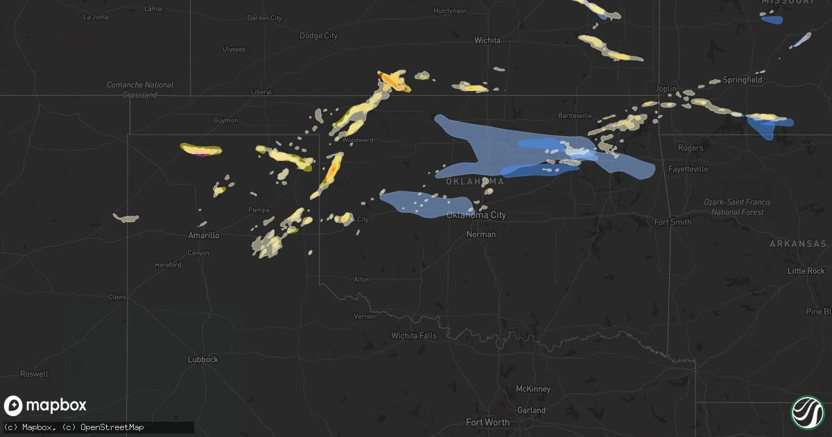
Hail Map in Oklahoma on August 13, 2023
Get this storm
August 13 map
$229
one time, instant access
Download today. No call, no setup
Keep the $229
Bought the map and want the full workflow? Apply the entire $229 to a subscription within 7 days. None of it is wasted.
Every map, not just this one
This buys you this map. Subscription and you get every map we run, in the markets you choose from a few cities to whole states to nationwide. Plus real-time alerts the moment a storm fires.
Contact data
Name, contact info, occupancy, even credit band for addresses in the footprint. You go from where it hit to who to call.
Become the source they trust
Unlimited branding weather history reports on demand. You already have the documented answer ready for the property owner, and you are the one who showed up with it.
Property data and RoofTrace estimates
Pull up any address you have got, its value and the exact code rules for that jurisdiction, straight from One Click Code. Then RoofTrace estimates the squares, pitch, and roof value, priced the way you price.
Storm reports in Oklahoma
Oklahoma
| Date | Description |
|---|---|
| 08/13/20236:27 PM CDT | A local report indicates 1.75 inch wind near 5 SSE Arnett |
| 08/13/20236:27 PM CDT | Time estimated from radar. |
| 08/13/202310:50 AM CDT | At least a dozen buildings damaged from thunderstorm winds. Trees are also reported on cars and several power poles have been damaged. |
| 08/13/20231:08 AM CDT | Large branches down. |
| 08/13/202312:59 AM CDT | Corrects previous tstm wnd dmg report from locust grove with corrected time. Roof taken off a shop building with block wall partially collapsed. Several large trees lea |
| 08/13/202312:46 AM CDT | Roof taken off a shop building with block wall partially collapsed. Several large trees leaning or uprooted. |
| 08/13/202312:45 AM CDT | A local report indicates 60 MPH wind near 1 S Chouteau |
| 08/13/202312:35 AM CDT | A local report indicates 70 MPH wind near 1 SW Tiawah |
| 08/13/202312:35 AM CDT | Pics of tree damage sent in from viewers; time estimated by radar. |
| 08/13/202312:35 AM CDT | Mesonet station wyno wynona. |
| 08/13/202312:30 AM CDT | Numerous large tree limbs down with power outages. Winds estimated 60 to 70 mph. |
| 08/13/202312:23 AM CDT | A local report indicates 95 MPH wind near 3 NW Catoosa |
| 08/13/202312:23 AM CDT | Tree debris in roadway. |
| 08/13/202312:23 AM CDT | Tree debris in roadway. |
| 08/13/202312:23 AM CDT | Tree in the road. |
| 08/13/202312:22 AM CDT | Tree debris in roadway. |
| 08/13/202312:21 AM CDT | Tree debris in roadway. |
| 08/13/202312:20 AM CDT | A local report indicates 75 MPH wind near 2 E Owasso |
| 08/13/202312:20 AM CDT | Large tree blocking the road. Many large trees down in the area. |
| 08/13/202312:20 AM CDT | Asos station ktul tulsa. |
| 08/13/202312:20 AM CDT | Several power poles down. |
| 08/13/202312:20 AM CDT | Trees uprooted. |
| 08/13/202312:20 AM CDT | Hangar damaged at gundys airport. Considerable tree damage and power lines down in the vicinity. Time estimated from radar. |
| 08/13/202312:19 AM CDT | Power lines down. |
| 08/13/202312:18 AM CDT | Very large tree limb down on the ne corner of 56th and 169 in the large field. Tons of large limbs down along 76th street between county line and hwy 169 - biggest ones |
| 08/13/202312:17 AM CDT | Power lines down. |
| 08/13/202312:09 AM CDT | Power line down. |
| 08/13/202312:01 AM CDT | A local report indicates 65 MPH wind near 2 SSW Sand Springs |
| 08/12/202311:50 PM CDT | A local report indicates 59 MPH wind near 2 NNW Perkins |
| 08/12/202311:45 PM CDT | A local report indicates 59 MPH wind near 7 N Coyle |
| 08/12/202311:40 PM CDT | A local report indicates 67 MPH wind near 7 N Coyle |
| 08/12/202311:38 PM CDT | A local report indicates 70 MPH wind near 4 SSW Lake Carl Blackwe |
| 08/12/202311:35 PM CDT | Mesonet station oilt oilton. |
| 08/12/202311:30 PM CDT | A local report indicates 89 MPH wind near 4 SSE Marshall |
| 08/12/202311:28 PM CDT | A local report indicates 70 MPH wind near Langston |
| 08/12/202311:27 PM CDT | A local report indicates 70 MPH wind near Kremlin |
| 08/12/202311:20 PM CDT | A local report indicates 74 MPH wind near 4 SSE Marshall |
| 08/12/202310:50 PM CDT | Pole knocked over and leaning against power pole. |
| 08/12/202310:50 PM CDT | Power outage and tree damage. |
| 08/12/20239:49 PM CDT | A local report indicates 65 MPH wind near 7 W Hinton |
| 08/12/20239:45 PM CDT | A local report indicates 58 MPH wind near 7 W Hinton |
| 08/12/20239:44 PM CDT | 3-inch tree limbs broken. |
| 08/12/20238:53 PM CDT | Asos station kcsm clinton. |
| 08/12/20238:06 PM CDT | A local report indicates 1.00 inch wind near 8 N Fort Supply |
All States Impacted by Hail Map on August 13, 2023
Cities Impacted by Hail Map on August 13, 2023
- Milan, TN
- Atwood, TN
- Mora, MO
- Sedalia, MO
- Friendship, TN
- Halls, TN
- Dyersburg, TN
- Smithton, MO
- Florence, MO
- Ionia, MO
- Cole Camp, MO
- Humboldt, TN
- Greenfield, TN
- Ripley, TN
- Gates, TN
- Barrington, NH
- Rochester, NH
- Berwick, ME
- Dover, NH
- Somersworth, NH
- Rollinsford, NH
- South Berwick, ME
- North Berwick, ME
- Cape Neddick, ME
- Wells, ME
- Bingham, ME
- Kingman, AZ
- Harmony, ME
- Athens, ME
- Guilford, ME
- Jay, ME
- Dixfield, ME
- Canton, ME
- Belgrade, ME
- Oakland, ME
- Smithfield, ME
- Farmington, ME
- Vienna, ME
- Norway, ME
- Dover Foxcroft, ME
- Garland, ME
- Carmel, ME
- Bangor, ME
- Levant, ME
- Ashland City, TN
- Charlotte, TN
- Cumberland Furnace, TN
- Vanleer, TN
- Dickson, TN
- White Bluff, TN
- Chapmansboro, TN
- Nashville, TN
- Pegram, TN
- Joelton, TN
- Whites Creek, TN
- Cunningham, TN
- Cumberland City, TN
- Erin, TN
- Charleston, ME
- Bradford, ME
- Milo, ME
- Winthrop, ME
- Readfield, ME
- Manchester, ME
- Stratford, TX
- Dalhart, TX
- Sunray, TX
- Gruver, TX
- Perryton, TX
- Wheeler, TX
- Mobeetie, TX
- Clarendon, TX
- Briscoe, TX
- Shamrock, TX
- Stinnett, TX
- Lincolnville, KS
- Burdick, KS
- Canadian, TX
- Strong City, KS
- Wilsey, KS
- Booker, TX
- Higgins, TX
- Emporia, KS
- Durham, OK
- Crawford, OK
- Arnett, OK
- Olpe, KS
- Clinton, ME
- Saint Albans, ME
- Monmouth, ME
- Oxford, ME
- Ardmore, TN
- Hedley, TX
- Waterford, ME
- Hope, KS
- Tampa, KS
- Ramona, KS
- Minot, ME
- Mechanic Falls, ME
- Nantucket, MA
- Wayne, ME
- Kents Hill, ME
- Leeds, ME
- Livermore, ME
- Turner, ME
- Livermore Falls, ME
- Buckfield, ME
- Poland, ME
- Auburn, ME
- Kittery, ME
- Beaverton, AL
- Sulligent, AL
- Blue Mountain, MS
- Ripley, MS
- New Portland, ME
- Solon, ME
- Cambridge, ME
- Sangerville, ME
- Eliot, ME
- Madbury, NH
- Durham, NH
- Lee, NH
- Fairfield, ME
- Corinth, ME
- Exeter, ME
- Tishomingo, MS
- Booneville, MS
- Gadsden, AL
- Iuka, MS
- Burnsville, MS
- Tiplersville, MS
- Falkner, MS
- Peru, ME
- Amarillo, TX
- Ashland, MS
- New Albany, MS
- Mclean, TX
- Dexter, ME
- Toney, AL
- Norton, MA
- South Easton, MA
- Raynham, MA
- Taunton, MA
- West Bridgewater, MA
- Bridgewater, MA
- Herington, KS
- Lost Springs, KS
- Ogunquit, ME
- Crossville, AL
- Collinsville, AL
- Lelia Lake, TX
- Pittsburg, NH
- Florence, AL
- Medina, TN
- Ashville, AL
- Pampa, TX
- Dolan Springs, AZ
- Gaylesville, AL
- Kenduskeag, ME
- Stetson, ME
- Hartford, KS
- Burlington, KS
- Tunnel Hill, GA
- Rocky Face, GA
- Dalton, GA
- Kansas City, MO
- Le Roy, KS
- Fort Supply, OK
- Wilmore, KS
- Lake City, KS
- Woodward, OK
- Neosho Falls, KS
- Colony, KS
- Buffalo, OK
- May, OK
- Fargo, OK
- Medicine Lodge, KS
- Sharon, KS
- Attica, KS
- Gridley, KS
- Piqua, KS
- Iola, KS
- Sayre, OK
- Hardtner, KS
- Elk City, OK
- Freedom, OK
- Kiowa, KS
- Neosho, MO
- Erie, KS
- Saint Paul, KS
- Miami, OK
- Quapaw, OK
- Pierce City, MO
- Monett, MO
- Custer City, OK
- Arapaho, OK
- Thomas, OK
- Weatherford, OK
- Geary, OK
- Hydro, OK
- Hinton, OK
- Watonga, OK
- Greenfield, OK
- Caldwell, KS
- Calumet, OK
- South Haven, KS
- El Reno, OK
- Okarche, OK
- Yukon, OK
- Piedmont, OK
- Bethany, OK
- Oklahoma City, OK
- Edmond, OK
- Jet, OK
- Nash, OK
- Enid, OK
- Kingfisher, OK
- Loyal, OK
- Dover, OK
- Hennessey, OK
- Galena, MO
- Cape Fair, MO
- Reeds Spring, MO
- Branson, MO
- Forsyth, MO
- Taneyville, MO
- Kissee Mills, MO
- Bradleyville, MO
- Rueter, MO
- Falcon, MO
- Lebanon, MO
- Richland, MO
- Crescent, OK
- Marshall, OK
- Mulhall, OK
- Coyle, OK
- Guthrie, OK
- Orlando, OK
- Stillwater, OK
- Kremlin, OK
- Pond Creek, OK
- Hunter, OK
- Garber, OK
- Lamont, OK
- Medford, OK
- Billings, OK
- Perry, OK
- Covington, OK
- Fairmont, OK
- Lucien, OK
- Drumright, OK
- Mannford, OK
- Jennings, OK
- Sapulpa, OK
- Bristow, OK
- Kellyville, OK
- Yale, OK
- Ripley, OK
- Cushing, OK
- Perkins, OK
- Agra, OK
- Sand Springs, OK
- Red Rock, OK
- Tonkawa, OK
- Theodosia, MO
- Thornfield, MO
- Ava, MO
- Rockaway Beach, MO
- Kirbyville, MO
- Powersite, MO
- Hollister, MO
- Laquey, MO
- Macks Creek, MO
- Camdenton, MO
- Eldridge, MO
- Roach, MO
- Montreal, MO
- Tulsa, OK
- Skiatook, OK
- Sperry, OK
- Morrison, OK
- Marland, OK
- Glencoe, OK
- Ralston, OK
- Pawnee, OK
- Fairfax, OK
- Maramec, OK
- Cedarcreek, MO
- Lead Hill, AR
- Protem, MO
- Isabella, MO
- Wasola, MO
- Glenwood, AL
- Strafford, MO
- Granby, MO
- Stark City, MO
- Miami, TX
- New Gloucester, ME
- Marshfield, MO
- Logan, NM
- Cheyenne, OK
- Bluff City, KS
- Milan, KS
- Aurora, MO
- Boaz, AL
- Laverne, OK
- Sarcoxie, MO
- Wentworth, MO
- Rock Spring, GA
- Crossville, IL
- Galesburg, KS
- Chanute, KS
- Alpine, TX
- Chelsea, OK
- Masterson, TX
- Rosston, OK
- Shattuck, OK
- Gage, OK
- Reydon, OK
- Skipperville, AL
- Ozark, AL
- Americus, KS
- Ash Grove, MO
- Miller, MO
- Mount Vernon, MO
- Everton, MO
- Texico, IL
- Iuka, IL
- Kell, IL
- Guntersville, AL
- Horton, AL
- Wellington, TX
- Resaca, GA
- Admire, KS
- Reading, KS
- Allen, KS
- Council Grove, KS
- Stotts City, MO
- Yates Center, KS
- Benedict, KS
- Fredonia, KS
- Toronto, KS
- Buffalo, KS
- Thayer, KS
- Vinita, OK
- Keenes, IL
- Bluford, IL
- La Harpe, KS
- Moran, KS
- Diamond, MO
- Sun City, KS
- Bruce, MS
- Arab, AL
- Ringgold, GA
- Bluejacket, OK
- Tuskegee, AL
- Woodville, AL
- Farley, MO
- Platte City, MO
- Verona, MO
- Crane, MO
- Follett, TX
- Stella, MO
- Sweetwater, OK
- Forest Home, AL
- Georgiana, AL
- Calhoun, GA
- Groom, TX
- Frankewing, TN
- Pulaski, TN
- Jones, OK
- Spencer, OK
- Afton, OK
- Dellrose, TN
- Oxford, KS
- Belle Plaine, KS
- Wellington, KS
- Winfield, KS
- Udall, KS
- Fairland, OK
- Nowata, OK
- Adrian, TX
- Cartersville, GA
- White, GA
- Seneca, MO
- Arcadia, OK
- Meridian, OK
- Elba, AL
- Goshen, AL
- Raymond, ME
- Burnt Prairie, IL
- Mooreland, OK
- Carmi, IL
- La Fayette, GA
- McCune, KS
- Girard, KS
- Walnut, KS
- Coldwater, KS
- Alva, OK
- Carter, OK
- Butler, OK
- Hatchechubbee, AL
- Hurtsboro, AL
- Johnsonville, IL
- Dix, IL
- Sims, IL
- Wayne City, IL
- Wyandotte, OK
- Pontotoc, MS
- Darrouzett, TX
- Holly Pond, AL
- Blountsville, AL
- Walnut Shade, MO
- Golden Gate, IL
- Fairfield, IL
- Barnhill, IL
- Mill Shoals, IL
- Tallassee, AL
- Cleveland, OK
- Owasso, OK
- Catoosa, OK
- Hominy, OK
- Gainesville, MO
- Yellville, AR
- Peel, AR
- Wynona, OK
- Terlton, OK
- Osage, OK
- Claremore, OK
- Wagoner, OK
- Inola, OK
- Broken Arrow, OK
- Chouteau, OK
- Pryor, OK
- Prue, OK
- Barnsdall, OK
- Collinsville, OK
- Vera, OK
- Ramona, OK
- Tahlequah, OK
- Peggs, OK
- Locust Grove, OK
- Hulbert, OK
- Salina, OK
- Rose, OK
- Proctor, OK
- Talala, OK
- Oologah, OK
- Kansas, OK
- Westville, OK
- Watts, OK
- Joplin, MO
- Noble, MO
- Adair, OK
- Niangua, MO
- Grove, OK
- Zalma, MO
- Gipsy, MO
- Bloomfield, MO
- Puxico, MO
- Big Cabin, OK
- Goodman, MO
- Parsons, KS
- Geuda Springs, KS
- Oran, MO
- Advance, MO
- Bell City, MO
- Okeene, OK
- Benton, MO
- Bertrand, MO
- Sikeston, MO
- Dexter, MO
- Dudley, MO
- Climax Springs, MO
- McGee, MO
- Waynesville, MO
- Morse, TX
- Wickliffe, KY
- Arkansas City, KS
- Luther, OK
- Wappapello, MO
- Barlow, KY
- Corinna, ME
- Wingo, KY
- Fulton, KY
- Clinton, KY
- Albertville, AL
- Dill City, OK
- Chaffee, MO
- La Center, KY
- Bardwell, KY
- Cunningham, KY
- Kevil, KY
- Paducah, KY
- West Paducah, KY
- Lebo, KS
- Bowling Green, KY
- Morgantown, KY
- Fancy Farm, KY


