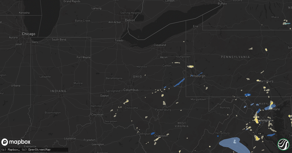
Hail Map in Ohio on August 13, 2021
Get this storm
August 13 map
$229
one time, instant access
Download today. No call, no setup
Keep the $229
Bought the map and want the full workflow? Apply the entire $229 to a subscription within 7 days. None of it is wasted.
Every map, not just this one
This buys you this map. Subscription and you get every map we run, in the markets you choose from a few cities to whole states to nationwide. Plus real-time alerts the moment a storm fires.
Contact data
Name, contact info, occupancy, even credit band for addresses in the footprint. You go from where it hit to who to call.
Become the source they trust
Unlimited branding weather history reports on demand. You already have the documented answer ready for the property owner, and you are the one who showed up with it.
Property data and RoofTrace estimates
Pull up any address you have got, its value and the exact code rules for that jurisdiction, straight from One Click Code. Then RoofTrace estimates the squares, pitch, and roof value, priced the way you price.
Storm reports in Ohio
Ohio
| Date | Description |
|---|---|
| 08/13/20216:36 PM CDT | Gas station canopy blown over. Time estimated via radar. |
| 08/13/20216:01 PM CDT | Multiple reports of trees down across the county. Location and time estimated based on radar. |
| 08/13/20215:48 PM CDT | Multiple reports of trees down across the county. Location and time estimated based on radar. |
| 08/13/20215:45 PM CDT | Photo of a large tree limb down in hopedale. |
| 08/13/20215:37 PM CDT | Multiple reports of trees down across the county. Location and time estimated based on radar. |
| 08/13/20215:34 PM CDT | Report of numerous trees down in the area. Time estimated based on radar. |
| 08/13/20215:16 PM CDT | 911 center reporting numerous trees down in flushing township. Time estimated based on radar. |
| 08/13/20215:00 PM CDT | 911 center reporting numerous reports of trees and power lines down throughout county. Time estimated based on radar. |
| 08/13/20214:57 PM CDT | 911 center reporting numerous reports of trees and power lines down throughout county. Time estimated based on radar. |
| 08/13/20214:34 PM CDT | 911 center reporting numerous trees down in county. Time estimated based on radar. |
| 08/13/20214:30 PM CDT | Photos of large broken tree limbs in salem. Time estimated based on radar. |
| 08/13/20214:29 PM CDT | Trees down along route 14 just outside of town. |
| 08/13/20214:28 PM CDT | 911 center reporting numerous trees down in county. Time estimated based on radar. |
| 08/13/20214:25 PM CDT | 911 center reporting numerous trees and power lines down in county. Time estimated based on radar |
| 08/13/20214:15 PM CDT | Numerous trees down from barlow to lower salem. |
| 08/13/20214:12 PM CDT | Small tree branches down |
| 08/13/20214:00 PM CDT | Trees down across the county including in new lexington... Crooksville... Shawnee... And monday creek. |
| 08/13/20213:20 PM CDT | Trees down. Time estimated from radar. |
| 08/13/20213:17 PM CDT | One tree down. Time estimated from radar. |
| 08/13/20213:10 PM CDT | Trees down in salem township and dexter. |
| 08/13/20213:10 PM CDT | Trees down on north concord road. |
| 08/13/20213:09 PM CDT | Trees down. Time estimated from radar. |
| 08/13/20213:06 PM CDT | Multiple trees downed on thrifton rd. Time estimated from radar. |
| 08/13/20213:01 PM CDT | Multiple trees down on dogtown rd. Time estimated from radar. |
| 08/13/20212:57 PM CDT | A local report indicates 61 MPH wind near 6 NE OAK HILL |
| 08/13/20212:55 PM CDT | One tree down. Time estimated from radar. |
| 08/13/20212:55 PM CDT | Trees down in columbia township. |
| 08/13/20212:46 PM CDT | Large tree branch downed near lynchburg. Time estimated from radar. |
| 08/13/20212:31 PM CDT | Large tree down and multiple large limbs down from nearby tree. Time estimated from radar. |
| 08/13/20212:30 PM CDT | Trees down on cr 61 in lawrence township... State route 93 in decatur township and township road 208 between ironton and kitts hill. |
| 08/13/20212:18 PM CDT | Trees down. Time estimated from radar. |
| 08/13/20212:13 PM CDT | Trees down. Time estimated from radar. |
| 08/13/20211:55 PM CDT | Fallen tree partially on a residence. |
| 08/13/20211:50 PM CDT | One tree down near the intersection of smith bridge rd and chillicothe pike. Home weather station reported a gust of 80 mph. |
| 08/13/20213:38 AM CDT | At 838 PM EDT, a severe thunderstorm was located over Niles, or near Warren, moving east at 30 mph. HAZARD...60 mph wind gusts. SOURCE...Radar indicated. IMPACT...Expect damage to trees and power lines. Locations impacted include... Youngstown, Warren, Boardman, Niles, Campbell, Hubbard, Lordstown, Vienna Center, Hilltop, Maplewood Park, Leavittsburg, Austintown, Struthers, Girard, Vienna, McDonald, Orangeville, Yankee Lake, Brookfield Center and Churchill. |
| 08/13/20213:05 AM CDT | At 804 PM EDT, a severe thunderstorm was located near Dalton, or 14 miles east of Wooster, moving east at 20 mph. HAZARD...60 mph wind gusts. SOURCE...Radar indicated. IMPACT...Expect damage to trees and power lines. Locations impacted include... Canton, Massillon, Green, North Canton, Louisville, Orrville, Hartville, Brewster, Navarre, Dalton, Waynesburg, East Sparta, New Franklin, Canal Fulton, East Canton, Clinton, Marshallville, Meyers Lake, Hills And Dales and Greentown. |
| 08/13/20211:13 AM CDT | At 612 PM EDT, severe thunderstorms were located along a line extending from Cambridge to near Barnesville, moving east at 20 mph. HAZARD...60 mph wind gusts and quarter size hail. SOURCE...Radar indicated. IMPACT...Minor hail damage to vehicles is possible. Expect wind damage to trees and power lines, resulting in some power outages. Locations impacted include... Cambridge, St. Clairsville, Barnesville, Freeport, Byesville, Bethesda, Antrim, Flushing, Dillonvale, Quaker City, Mount Pleasant, and Belmont. |
| 08/13/202112:56 AM CDT | At 555 PM EDT, a severe thunderstorm was located near Barnesville, moving northeast at 25 mph. HAZARD...60 mph wind gusts and quarter size hail. SOURCE...Radar indicated. IMPACT...Minor hail damage to vehicles is possible. Expect wind damage to trees and power lines, resulting in some power outages. Locations impacted include... Barnesville, Bethesda, Antrim, Quaker City, Senecaville, Belmont, Holloway, Lore City, Morristown, Old Washington, Salesville, and Fairview. |
| 08/13/202112:45 AM CDT | At 544 PM EDT, a severe thunderstorm was located near New Concord, or 11 miles east of Zanesville, moving northeast at 25 mph. HAZARD...60 mph wind gusts and quarter size hail. SOURCE...Radar indicated. IMPACT...Minor hail damage to vehicles is possible. Expect wind damage to trees and power lines, resulting in some power outages. Locations impacted include... Cambridge, New Concord, Byesville, Senecaville, Pleasant City, Lore City, Old Washington, Norwich, Boden, Salt Fork State Park, and Kimbolton. |
| 08/13/202112:29 AM CDT | At 529 PM EDT, a severe thunderstorm was located over Caldwell, moving northeast at 25 mph. HAZARD...60 mph wind gusts and quarter size hail. SOURCE...Radar indicated. IMPACT...Minor hail damage to vehicles is possible. Expect wind damage to trees and power lines, resulting in some power outages. Locations impacted include... Caldwell, Dudley, Summerfield, Belle Valley, Sarahsville, Seneca Lake Park, and Wolf Run State Park. |
| 08/13/202112:24 AM CDT | At 524 PM EDT, a severe thunderstorm was located near Salem, moving east at 30 mph. HAZARD...60 mph wind gusts and quarter size hail. SOURCE...Radar indicated. IMPACT...Minor hail damage to vehicles is possible. Expect wind damage to trees and power lines, resulting in some power outages. Locations impacted include... Salem, Columbiana, Leetonia, New Waterford, Rogers, North Georgetown, and Winona. |
| 08/13/202112:13 AM CDT | At 513 PM EDT, a severe thunderstorm was located 10 miles north of Marietta, moving northeast at 30 mph. HAZARD...60 mph wind gusts and quarter size hail. SOURCE...Radar indicated. IMPACT...Minor hail damage to vehicles is possible. Expect wind damage to trees and power lines, resulting in some power outages. Locations impacted include... Dudley, Summerfield, Lewisville, Dexter City, Antioch, Stafford, Graysville, Harriettsville, and Rinard Mills. |
| 08/12/202111:18 PM CDT | At 418 PM EDT, a severe thunderstorm was located near Belfast, moving east at 15 mph. HAZARD...60 mph wind gusts and quarter size hail. SOURCE...Radar indicated. IMPACT...Minor hail damage to vehicles is possible. Expect wind damage to trees and power lines. Locations impacted include... Hillsboro, Peebles, Marshall, Sardinia, Kincaid Springs, Belfast, Rocky Fork Point, Cynthiana, Highland Holiday, New Market, Emerald, Mowrystown, Sinking Spring, Rocky Fork Lake, Poplar Grove, May Hill, Serpent Mound, Locust Grove, Fincastle and Berrysville. |
| 08/12/202111:07 PM CDT | At 406 PM EDT, severe thunderstorms were located along a line extending from near Grosse Ile to Petersburg to near Fayette, moving east at 20 mph. HAZARD...60 mph wind gusts. SOURCE...Radar indicated. IMPACT...Expect damage to roofs, siding, and trees. Severe thunderstorms will be near... Flat Rock, Dundee and Petersburg around 410 PM EDT. Ida around 425 PM EDT. Lambertville around 430 PM EDT. Temperance around 435 PM EDT. Monroe around 450 PM EDT. Luna Pier around 455 PM EDT.Other locations impacted by these severe thunderstorms includeNewport, Seneca, Lime Creek, Estral Beach, Munson, Ogden Center,Canandaigua, Toledo Beach, Erie and South Rockwood. |
| 08/12/202111:03 PM CDT | At 403 PM EDT, a severe thunderstorm was located over Williamsport, moving northeast at 20 mph. HAZARD...60 mph wind gusts and quarter size hail. SOURCE...Radar indicated. IMPACT...Minor hail damage to vehicles is possible. Expect wind damage to trees and power lines. Locations impacted include... Circleville, Ashville, South Bloomfield, Williamsport, Logan Elm Village, Fox, Aw Marion State Park, State Route 207 at US Route 22 and State Route 138 at US Route 22. |
| 08/12/202110:54 PM CDT | At 354 PM EDT, severe thunderstorms were located along a line extending from near New Holland to near Hillsboro, moving east at 25 mph. HAZARD...60 mph wind gusts. SOURCE...Radar indicated. IMPACT...Expect damage to trees and power lines. Locations impacted include... Chillicothe, Hillsboro, Greenfield, Kingston, Bainbridge, New Holland, Kincaid Springs, Rocky Fork Point, Highland Holiday, Cynthiana, North Folk Village, Good Hope, Frankfort, Clarksburg, South Salem, East Monroe, Austin, Knockemstiff, Rock Mills and New Martinsburg. |
| 08/12/202110:20 PM CDT | At 320 PM EDT, a severe thunderstorm was located near Lake Vesuvius, moving northeast at 20 mph. HAZARD...60 mph wind gusts. SOURCE...Radar indicated. IMPACT...Expect damage to roofs, siding, and trees. Locations impacted include... Ironton, Lake Vesuvius, Gallia, Vernon, Waterloo, Aid and Pedro. |
| 08/12/202110:19 PM CDT | At 319 PM EDT, a severe thunderstorm was located near Clarktown, moving east at 40 mph. HAZARD...60 mph wind gusts. SOURCE...Radar indicated. IMPACT...Expect damage to trees and power lines. Locations impacted include... Clarktown, Stockdale, Portsmouth Regional Airport, Minford and State Route 335 at State Route 776. |
| 08/12/20218:00 PM CDT | Numerous trees down across southern half of the county. |
| 08/12/20217:21 PM CDT | Tree down and telephone pole down. |
All States Impacted by Hail Map on August 13, 2021
Cities Impacted by Hail Map on August 13, 2021
- Glen Aubrey, NY
- Whitney Point, NY
- Lisle, NY
- Dill City, OK
- Yellville, AR
- Lead Hill, AR
- Fort Mcdowell, AZ
- Pottsboro, TX
- Oakland, KY
- Chantilly, VA
- Centreville, VA
- Butler, OK
- Paden, OK
- Williamsport, OH
- New Holland, OH
- Prince Frederick, MD
- Catlett, VA
- Reston, VA
- Humboldt, TN
- Bells, TN
- Oklahoma City, OK
- Checotah, OK
- Pine Valley, UT
- New Harmony, UT
- Chandlersville, OH
- Willcox, AZ
- Foss, OK
- Cordell, OK
- Bessie, OK
- Corn, OK
- Rogers, AR
- Garfield, AR
- Cord, AR
- Windsor, NY
- Sweetwater, OK
- Booneville, AR
- Greensboro, MD
- Howard, OH
- Danville, OH
- Ash Fork, AZ
- Falls Church, VA
- China Grove, NC
- Mount Ulla, NC
- Sedona, AZ
- Stuttgart, AR
- Gould, OK
- Middlebourne, WV
- Sistersville, WV
- Pine, AZ
- Tappahannock, VA
- Saint Stephens Church, VA
- Phoenix, AZ
- Globe, AZ
- Miami, AZ
- Slingerlands, NY
- Voorheesville, NY
- South Charleston, WV
- Alum Creek, WV
- Chesapeake, OH
- Ballston Lake, NY
- Ballston Spa, NY
- Galway, NY
- McConnellsburg, PA
- Muskogee, OK
- Webbers Falls, OK
- Georgetown, DE
- Searchlight, NV
- New Blaine, AR
- Scranton, AR
- East Meredith, NY
- Davenport, NY
- Davenport Center, NY
- Oneonta, NY
- Crawfordsville, AR
- Proctor, AR
- Prescott, AR
- Covington, VA
- Hancock, MD
- Warfordsburg, PA
- Bedford, VA
- Great Falls, VA
- Fombell, PA
- New Brighton, PA
- Owings, MD
- Friendship, MD
- Dunkirk, MD
- Okmulgee, OK
- Haskell, OK
- Boynton, OK
- Morris, OK
- Colony, OK
- Valley Springs, AR
- Baltimore, MD
- Henderson, MD
- Goldsboro, MD
- Colorado City, AZ
- Wellsville, PA
- Dover, PA
- Bentonville, AR
- Zanesville, OH
- Peridot, AZ
- Mount Pleasant, NC
- Shermans Dale, PA
- Landisburg, PA
- Carlisle, PA
- Vinton, OH
- Bidwell, OH
- Langsville, OH
- Saint Johnsville, NY
- Congress, AZ
- Alderson, WV
- Meadow Bridge, WV
- Green Sulphur Springs, WV
- Salisbury, NC
- Dolgeville, NY
- Burnt Hills, NY
- Barnsdall, OK
- Black Canyon City, AZ
- Pine Bluff, AR
- Bowie, MD
- New Freedom, PA
- Glen Rock, PA
- Freeland, MD
- Witter, AR
- Eufaula, OK
- Barboursville, VA
- Gordonsville, VA
- Sod, WV
- Sumerco, WV
- Sayre, OK
- Elk City, OK
- Ogallala, NE
- Mountain Home, AR
- Vian, OK
- Mena, AR
- Rose, OK
- King George, VA
- Harrington, DE
- East Waterford, PA
- Blairs Mills, PA
- Orbisonia, PA
- Colonial Beach, VA
- Dillsburg, PA
- Covington, TN
- Eureka Springs, AR
- Mooresville, NC
- Keswick, VA
- Corning, NY
- Supai, AZ
- Williams, AZ
- Montoursville, PA
- Williamsport, PA
- Coalgate, OK
- Kingsport, TN
- Saint David, AZ
- Federalsburg, MD
- Denton, MD
- Greenwood, DE
- Paris, AR
- Subiaco, AR
- Grandin, MO
- Poplar Bluff, MO
- Bon Aqua, TN
- Burns, TN
- Arapaho, OK
- Gold Hill, NC
- Feura Bush, NY
- Selkirk, NY
- Coeymans Hollow, NY
- Rochester, PA
- Beaver Falls, PA
- Connellsville, PA
- Dunbar, PA
- Granite, OK
- Willow, OK
- Waverly, TN
- Hurricane Mills, TN
- Edmond, OK
- Lothian, MD
- Brandywine, MD
- Upper Marlboro, MD
- Centerville, TN
- Nunnelly, TN
- Lobelville, TN
- Central, UT
- Stigler, OK
- Mayer, AZ
- Mcalester, OK
- Decatur, AR
- Gravette, AR
- Franklin, TN
- Greencastle, PA
- Port Royal, VA
- Woodford, VA
- Rappahannock Academy, VA
- Fredericksburg, VA
- Potomac, MD
- Doniphan, MO
- Lascassas, TN
- Lebanon, TN
- Lutherville Timonium, MD
- Pikesville, MD
- Stevenson, MD
- Salem, OH
- Beloit, OH
- Washingtonville, OH
- Alliance, OH
- Damascus, OH
- Leetonia, OH
- Arlington, TN
- Eads, TN
- Sapulpa, OK
- Kiefer, OK
- Fairfax, VA
- Oakton, VA
- Vienna, VA
- Hillsboro, OH
- Herndon, VA
- Jenks, OK
- Glenpool, OK
- Newport, AR
- Newark Valley, NY
- Binghamton, NY
- Endicott, NY
- Johnson City, NY
- Maine, NY
- Leesburg, OH
- Willisburg, KY
- Lawrenceburg, KY
- Smiths Grove, KY
- Colcord, OK
- Gentry, AR
- Fisher, AR
- White Hall, AR
- Clinton, NY
- Nipton, CA
- York, PA
- Thomasville, PA
- Charleston, WV
- Golden, MO
- Eagle Rock, MO
- Seaford, DE
- Bridgeville, DE
- Cumberland, OH
- Belle Valley, OH
- Caldwell, OH
- Paulden, AZ
- Reydon, OK
- Peel, AR
- Marietta, OH
- Lowell, OH
- Whipple, OH
- Nanjemoy, MD
- Rockbridge Baths, VA
- Goshen, VA
- Bunch, OK
- Waynesboro, PA
- Glenwood, MD
- Dayton, MD
- Glenelg, MD
- Ravena, NY
- Andover, OH
- Weiner, AR
- Fountain Hills, AZ
- Gladstone, VA
- Wingina, VA
- Sheffield, AL
- Kirkwood, NY
- Conklin, NY
- Paris, KY
- Warner, OK
- Gore, OK
- Gwynn Oak, MD
- Phoenix, MD
- Cockeysville, MD
- Sparks Glencoe, MD
- Hunt Valley, MD
- Sterling, VA
- Boyds, MD
- Springfield, VA
- Poolesville, MD
- Fairfax Station, VA
- Ashburn, VA
- Germantown, MD
- Burke, VA
- Annandale, VA
- Clarksburg, MD
- Seminole, TX
- Payson, AZ
- Hope, AR
- Harrison, AR
- New Cumberland, PA
- Harrisburg, PA
- Marydel, DE
- Camden Wyoming, DE
- Felton, DE
- Carter, OK
- Sentinel, OK
- Bardstown, KY
- Garrett, WY
- Greenfield, OH
- Clarksburg, OH
- New Concord, OH
- Norwich, OH
- Albany, NY
- Delmar, NY
- East Berne, NY
- Clarksville, NY
- Blue Rock, OH
- Duncan Falls, OH
- Laurel, MD
- Glenn Dale, MD
- Quaker City, OH
- Adamsville, TN
- Cedar City, UT
- Keystone, NE
- Gaithersburg, MD
- Gainesville, VA
- Haymarket, VA
- Ripley, MS
- Blue Mountain, MS
- Palmyra, VA
- Scottsville, VA
- Wardensville, WV
- Midland, VA
- Nokesville, VA
- Warrenton, VA
- Bealeton, VA
- Brownsville, TN
- Brighton, TN
- Little Falls, NY
- Gambrills, MD
- Davidsonville, MD
- Trout Run, PA
- Wynne, AR
- Cherry Valley, AR
- Mercersburg, PA
- Stephens City, VA
- Saint Joe, AR
- Linden, TN
- Mangum, OK
- Spring Grove, PA
- East Berlin, PA
- Rosedale, MS
- Bella Vista, AR
- Hiwasse, AR
- Peach Springs, AZ
- Choctaw, OK
- Harrah, OK
- Bethany, OK
- Jones, OK
- Spencer, OK
- Ashford, WV
- Columbia, VA
- Cartersville, VA
- Dickson, TN
- Hazen, AR
- Cammal, PA
- Lock Haven, PA
- North Bend, PA
- Belmont, OH
- Flushing, OH
- Salina, OK
- Everton, AR
- Cheyenne, OK
- Ranger, WV
- Branchland, WV
- Cambridge, OH
- Clinton, OK
- Dahlgren, VA
- Windsor Mill, MD
- Towson, MD
- Catonsville, MD
- Monkton, MD
- Town Creek, AL
- Buckingham, VA
- Depew, OK
- Erick, OK
- Mesa, AZ
- Clendenin, WV
- Lebanon Junction, KY
- Boston, KY
- Monroe, MI
- Ashland, VA
- Berkeley Springs, WV
- Great Cacapon, WV
- Church Hill, TN
- Wheeler, TX
- Shamrock, TX
- McRae, AR
- Locust Grove, OK
- Rimrock, AZ
- Pleasant City, OH
- Millerstown, PA
- Liverpool, PA
- Scottdale, PA
- Dawson, PA
- Mounds, OK
- Poland, NY
- Newport, NY
- Fort Plain, NY
- Jeffersonton, VA
- Remington, VA
- Harrisonburg, VA
- Broad Run, VA
- White Bluff, TN
- Falkner, MS
- Ashland, MS
- Richwood, WV
- Claypool, AZ
- Mount Sterling, OH
- Washington Court House, OH
- Norfork, AR
- Vernon, TX
- Cave Springs, AR
- Charles Town, WV
- Ranson, WV
- Kearneysville, WV
- Denmark, TN
- Jackson, TN
- Stafford, VA
- Kitts Hill, OH
- Ironton, OH
- Lawrenceburg, TN
- Leoma, TN
- Artemas, PA
- Clarksville, TX
- Tulsa, OK
- San Carlos, AZ
- Sardinia, OH
- Winchester, OH
- Zelienople, PA
- Beaver, PA
- Darlington, PA
- Berryville, AR
- Roosevelt, AZ
- Lyles, TN
- Lore City, OH
- Byesville, OH
- Salesville, OH
- Senecaville, OH
- Port Republic, MD
- Aquasco, MD
- Huntingtown, MD
- Porum, OK
- Murphy, NC
- Lorton, VA
- Meridianville, AL
- Huntsville, AL
- Selmer, TN
- Bethel Springs, TN
- Altus Afb, OK
- Altus, OK
- Kansas, OK
- Jasper, AR
- Crowell, TX
- Junction City, OH
- Sevierville, TN
- Bosler, WY
- Edgewater, MD
- Harwood, MD
- Seven Valleys, PA
- Idabel, OK
- Denison, TX
- Dawson, GA
- Charlottesville, VA
- Rattan, OK
- Lone Wolf, OK
- Delmar, MD
- Delmar, DE
- Decatur, AL
- Trinity, AL
- Humphrey, AR
- Arnett, OK
- Sugar Tree, TN
- Harts, WV
- Julian, WV
- Danville, WV
- Huntsville, AR
- Waldorf, MD
- Ruther Glen, VA
- Cedarcreek, MO
- Smyrna, TN
- Murfreesboro, TN
- Rio Rico, AZ
- Painted Post, NY
- Deposit, NY
- Christiansburg, VA
- Riner, VA
- Lucasville, OH
- Burbank, OK
- Alexandria, VA
- Fort Belvoir, VA
- Brandy Station, VA
- Rixeyville, VA
- Lowell, AR
- Wellston, OK
- Mcloud, OK
- Meeker, OK
- Broken Arrow, OK
- Lemoyne, NE
- Lebanon, KY
- Roseville, OH
- Pedro, OH
- Macon, GA
- Atwood, TN
- Hillsboro, AL
- Manchester, MD
- Watertown, TN
- Concord, NC
- Griffithsville, WV
- Alkol, WV
- Yawkey, WV
- Fayetteville, OH
- Lynchburg, OH
- Midland, OH
- Blanchester, OH
- Bixby, OK
- Camp Verde, AZ
- Pawnee, OK
- Mason, TN
- Prague, OK
- Laurel, DE
- Sandstone, WV
- Ashland, KY
- Mount Judea, AR
- Savanna, OK
- Laveen, AZ
- Kiahsville, WV
- West Union, WV
- New Milton, WV
- Mount Solon, VA
- Bridgewater, VA
- Aroda, VA
- Kents Store, VA
- Rochelle, VA
- Mineral, VA
- North Garden, VA
- Grottoes, VA
- Greenwood, VA
- Staunton, VA
- Maidens, VA
- Henrico, VA
- Crimora, VA
- Ruckersville, VA
- Fork Union, VA
- Stanardsville, VA
- Bumpass, VA
- Sandy Hook, VA
- Earlysville, VA
- Dyke, VA
- Glen Allen, VA
- Fishersville, VA
- Rockville, VA
- Oilville, VA
- Crozet, VA
- Powhatan, VA
- Afton, VA
- Free Union, VA
- Stuarts Draft, VA
- Manakin Sabot, VA
- Goochland, VA
- Orange, VA
- Radiant, VA
- Louisa, VA
- Waynesboro, VA
- Crozier, VA
- Lyndhurst, VA
- State Farm, VA
- Somerset, VA
- Troy, VA
- Gum Spring, VA
- Montpelier, VA
- Herkimer, NY
- Round Lake, NY
- Schenectady, NY
- Rexford, NY
- Amsterdam, NY
- Schuylerville, NY
- Fort Hunter, NY
- Mechanicville, NY
- Pattersonville, NY
- Hagaman, NY
- Clifton Park, NY
- Broadalbin, NY
- Saratoga Springs, NY
- Fort Johnson, NY
- Stillwater, NY
- Schaghticoke, NY
- Tribes Hill, NY
- Gloversville, NY
- Johnstown, NY
- Fonda, NY
- Chenango Forks, NY
- Castle Creek, NY
- Port Crane, NY
- Glenmont, NY
- Castleton On Hudson, NY
- Hurricane, WV
- Winfield, WV
- Culloden, WV
- Scott Depot, WV
- Frederick, MD
- Middletown, MD
- Walkersville, MD
- New Market, MD
- Mount Airy, MD
- Union Bridge, MD
- Owings Mills, MD
- Parkville, MD
- Nottingham, MD
- Sykesville, MD
- Glen Arm, MD
- Marriottsville, MD
- Woodstock, MD
- Perry Hall, MD
- Randallstown, MD
- Rosedale, MD
- Ellicott City, MD
- West Friendship, MD
- Damascus, MD
- Montgomery Village, MD
- Loveville, MD
- Saint Leonard, MD
- Leonardtown, MD
- Clements, MD
- Chaptico, MD
- Mechanicsville, MD
- Hollywood, MD
- Broomes Island, MD
- Duke, OK
- Hollis, OK
- Wickenburg, AZ
- Crown King, AZ
- Aguila, AZ
- Morristown, AZ
- Scottsdale, AZ
- Apache Junction, AZ
- Gold Canyon, AZ
- New Hartford, NY
- Sauquoit, NY
- Old Washington, OH
- Follansbee, WV
- Cadiz, OH
- Dillonvale, OH
- Brilliant, OH
- Colliers, WV
- Adena, OH
- Saint Clairsville, OH
- Mount Pleasant, OH
- Rayland, OH
- Mingo Junction, OH
- Chambersburg, PA
- Harpers Ferry, WV
- Shepherdstown, WV
- Shenandoah Junction, WV
- Oakdale, PA
- Coraopolis, PA
- Imperial, PA
- Pittsburgh, PA
- Verona, PA
- Oakmont, PA
- Cheswick, PA
- New Kensington, PA
- Tarentum, PA
- Springdale, PA


