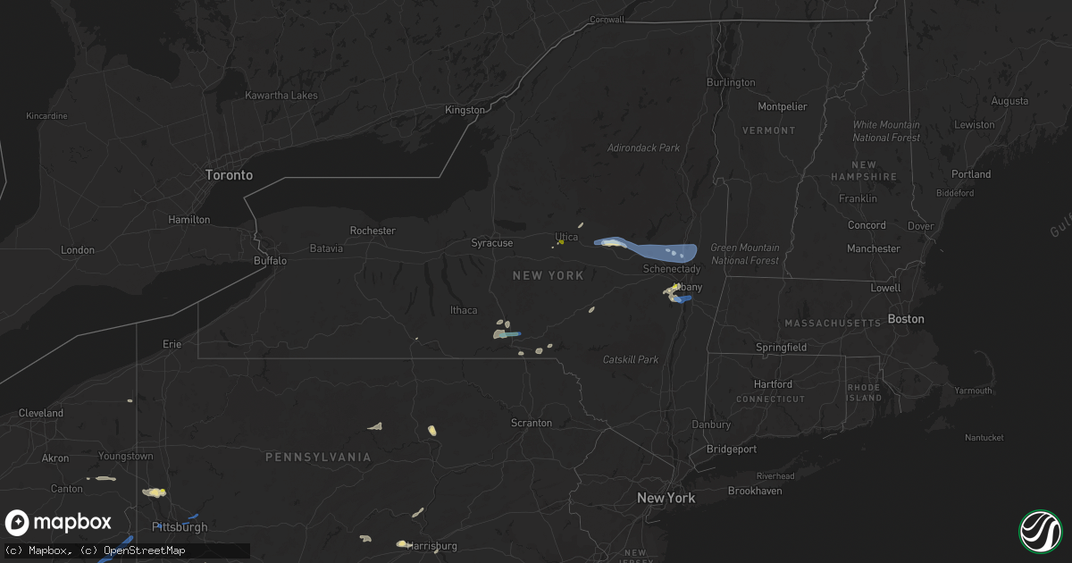
Hail Map in New York on August 13, 2021
Get this storm
August 13 map
$229
one time, instant access
Download today. No call, no setup
Keep the $229
Bought the map and want the full workflow? Apply the entire $229 to a subscription within 7 days. None of it is wasted.
Every map, not just this one
This buys you this map. Subscription and you get every map we run, in the markets you choose from a few cities to whole states to nationwide. Plus real-time alerts the moment a storm fires.
Contact data
Name, contact info, occupancy, even credit band for addresses in the footprint. You go from where it hit to who to call.
Become the source they trust
Unlimited branding weather history reports on demand. You already have the documented answer ready for the property owner, and you are the one who showed up with it.
Property data and RoofTrace estimates
Pull up any address you have got, its value and the exact code rules for that jurisdiction, straight from One Click Code. Then RoofTrace estimates the squares, pitch, and roof value, priced the way you price.
Storm reports in New York
New York
| Date | Description |
|---|---|
| 08/13/20216:46 PM CDT | Tree down on road. |
| 08/13/20216:42 PM CDT | Tree down on scott avenue |
| 08/13/20216:30 PM CDT | Two medium size trees down... One on lines |
| 08/13/20216:26 PM CDT | Trees and wires down. |
| 08/13/20216:21 PM CDT | Tree down on dutch quad at university of albany. |
| 08/13/20216:21 PM CDT | Mulitple large limbs and small trees down on colonial quad on the university at albany campus |
| 08/13/20216:21 PM CDT | Tree blocking road. |
| 08/13/20216:16 PM CDT | Tree down on road. |
| 08/13/20216:10 PM CDT | A local report indicates 1.00 inch wind near VOORHEESVILLE |
| 08/13/20215:45 PM CDT | Corrects previous tstm wnd dmg report from schenevus. Tree down on wires blocking rd. Time estimated from radar. |
| 08/13/20214:35 PM CDT | Large tree down blocking a line on west grand street. |
| 08/13/20214:29 PM CDT | 2 trees down on route 5s near on ramp to nys thruway. |
| 08/13/20214:18 PM CDT | Strong thunderstorm winds knocked down tree and wires. |
| 08/13/20214:11 PM CDT | Strong thunderstorm winds knocked down wires on road. |
| 08/13/20214:07 PM CDT | A local report indicates 1.00 inch wind near NWS BINGHAMTON |
| 08/13/20213:54 PM CDT | Wires down on structure on silver beach rd. |
| 08/13/20213:51 PM CDT | Pine tree snapped. Lots of large branches down. Power out. |
| 08/13/20213:51 PM CDT | Trees on wires. |
| 08/13/20213:51 PM CDT | Multiple trees down and trees on wires on route 50 between middleline and brookline rd. |
| 08/13/20213:48 PM CDT | Tree on car on lake rd. |
| 08/13/20213:47 PM CDT | Wires down on ballston ave. |
| 08/13/20213:45 PM CDT | Tree down on wires on brookline rd. |
| 08/13/20213:40 PM CDT | Tree down on house on lakeside ave. |
| 08/13/20213:34 PM CDT | Wires down. |
| 08/13/20213:31 PM CDT | Power pole down across road. |
| 08/13/20213:15 PM CDT | A large tree down at the intersection of mcdonald dr. And noonan rd. |
| 08/13/20213:11 PM CDT | Tree down across road. |
| 08/13/20213:10 PM CDT | Siding and gutter damage to house... And large limbs down at hagaman rd and cr 107. |
| 08/13/20212:56 PM CDT | Tree snapped on new york 29 and west green st. |
| 08/13/20212:56 PM CDT | Tree snapped on west state st. And hall ave. |
| 08/13/20212:51 PM CDT | Large branches down along with a trampoline blown onto new york highway 29 near earl rd. |
| 08/13/20212:41 PM CDT | Widespread tree damage in caroga. Damage consist of many medium to large size branches along with two trees down. |
| 08/13/20212:36 PM CDT | Trees on wires. |
| 08/13/20212:30 PM CDT | Wires down on n main st. |
| 08/13/20212:28 PM CDT | A local report indicates 65 MPH wind near 2 ESE OPPENHEIM |
| 08/13/20212:16 PM CDT | Trees on wires. |
| 08/13/20212:12 PM CDT | Large oak tree down. |
| 08/13/20212:02 PM CDT | Tree down on wires near north williams street and garden street... Partially blocking road |
| 08/13/20212:01 PM CDT | Large oak tree down. |
| 08/13/20211:40 PM CDT | Trees and wires down blocking road in newport... Ny |
| 08/13/20211:12 PM CDT | A local report indicates 1.00 inch wind near UTICA |
| 08/13/20215:51 AM CDT | At 1050 PM EDT, a severe thunderstorm was located near East Concord, or 17 miles south of East Aurora, moving east at 20 mph. HAZARD...60 mph wind gusts and penny size hail. SOURCE...Radar indicated. IMPACT...Expect damage to trees and power lines. Locations impacted include... Boston, Springville, Colden, Arcade, Houghton, Chaffee, East Concord, Varysburg, Ashford Hollow and Yorkshire. |
| 08/13/20213:47 AM CDT | At 847 PM EDT, a severe thunderstorm was located over Staatsburg, or near Rhinebeck, moving east at 15 mph. HAZARD...60 mph wind gusts and quarter size hail. SOURCE...Radar indicated. IMPACT...Hail damage to vehicles is expected. Expect wind damage to roofs, siding, and trees. Locations impacted include... Rhinebeck, Amenia, Pine Plains, Stanfordville, Staatsburg, Bethel, Milan, Smithfield, Ellerslie, Pachin Mills, Ancramdale, Norrie Heights, Dutchess County Fairgrounds, Lithgow, Rhinecliff, Dewitt Mills, Attlebury, Shunpike, Pleasant Plains and Shekomeko. |
| 08/13/20213:12 AM CDT | At 812 PM EDT, a severe thunderstorm was located near Kerhonkson, or 8 miles north of Ellenville, moving east at 25 mph. HAZARD...60 mph wind gusts and quarter size hail. SOURCE...Radar indicated. IMPACT...Hail damage to vehicles is expected. Expect wind damage to roofs, siding, and trees. Locations impacted include... Kingston, New Paltz, Rhinebeck, Hyde Park, Hurley, Highland, Fairview, High Falls, Kerhonkson, Staatsburg, Tillson, Napanoch, Port Ewen, Wawarsing, Lloyd, Esopus, Rosendale, Marbletown, Cherrytown and Rolling Meadows. |
| 08/13/20212:28 AM CDT | At 728 PM EDT, severe thunderstorms were located along a line extending from Loudonville to near Westerlo, moving east at 15 mph. HAZARD...60 mph wind gusts and quarter size hail. SOURCE...Radar indicated. IMPACT...Hail damage to vehicles is expected. Expect wind damage to roofs, siding, and trees. Locations impacted include... Albany, Troy, East Greenbush, Watervliet, Rensselaer, Colonie, Delmar, Menands, Ravena, Green Island, Grafton, Castleton-On-Hudson, Loudonville, West Sand Lake, Center Brunswick, Wyantskill, Averill Park, Feura Bush, Selkirk and Wynantskill. |
| 08/13/20211:45 AM CDT | At 645 PM EDT, a severe thunderstorm was located near Voorheesville, or near Delmar, moving east at 10 mph. HAZARD...60 mph wind gusts and quarter size hail. SOURCE...Radar indicated. IMPACT...Hail damage to vehicles is expected. Expect wind damage to roofs, siding, and trees. Locations impacted include... Albany, Cohoes, Watervliet, Colonie, Latham, Delmar, Guilderland, Menands, Berne, Voorheesville, Green Island, Loudonville, Feura Bush, New Scotland, Knox, Clarksville, Shakers, Bleecker Stadium, East Berne and Spawn Hollow. |
| 08/13/20211:42 AM CDT | At 642 PM EDT, severe thunderstorms were located along a line extending from Downsville to near East Branch to Peabrook, moving northeast at 30 mph. HAZARD...60 mph wind gusts and penny size hail. SOURCE...Radar indicated. IMPACT...Expect damage to roofs, siding, and trees. Locations impacted include... Rockland, Liberty, Neversink, Walton, Colchester, Hamden, Andes, Hancock, Fremont and Margaretville. |
| 08/13/20211:38 AM CDT | At 638 PM EDT, a severe thunderstorm was located over Davenport, or 10 miles east of Oneonta, moving northeast at 25 mph. HAZARD...60 mph wind gusts and penny size hail. SOURCE...Radar indicated. IMPACT...Expect damage to roofs, siding, and trees. Locations impacted include... Davenport, Worcester, Kortright, Schenevus, East Meredith, Butts Corner, Fergusonville and Davenport Center. |
| 08/13/202112:59 AM CDT | At 559 PM EDT, a severe thunderstorm was located near Deposit, moving east at 15 mph. HAZARD...60 mph wind gusts and quarter size hail. SOURCE...Radar indicated. IMPACT...Hail damage to vehicles is expected. Expect wind damage to roofs, siding, and trees. Locations impacted include... Walton, Colchester, Hamden, Downsville, Stilesville, Trout Creek, Cannonsville, Beerston, Loomis and Shinhopple. |
| 08/13/202112:37 AM CDT | At 536 PM EDT, a severe thunderstorm was located over Kirkwood, or 8 miles east of Binghamton, moving east at 15 mph. HAZARD...60 mph wind gusts and quarter size hail. SOURCE...Radar indicated. IMPACT...Hail damage to vehicles is expected. Expect wind damage to roofs, siding, and trees. Locations impacted include... Sanford, Deposit, Windsor, Afton, Harpursville, Nineveh, Stilesville, Oquaga Creek State Park and East Windsor. |
| 08/13/202112:31 AM CDT | At 531 PM EDT, severe thunderstorms were located along a line extending from near Fort Plain to near Richfield Springs, moving east at 15 mph. HAZARD...60 mph wind gusts and quarter size hail. SOURCE...Trained weather spotters reported downed trees and nickel size hail in Canajoharie. IMPACT...Hail damage to vehicles is expected. Expect wind damage to roofs, siding, and trees. Locations impacted include... Gloversville, Johnstown, Canajoharie, Fonda, Fort Plain, Ephratah, Broadalbin, Sharon Springs, Fort Johnson, Ames, Tribes Hill, Perth, Glen, Berkshire, Fultonville, Palatine Bridge, Nelliston, West Perth, Cook Corners and Church Corners. |
| 08/13/202112:24 AM CDT | At 524 PM EDT, a severe thunderstorm was located near Ridgebury, or near Chemung, moving east at 30 mph. HAZARD...60 mph wind gusts and quarter size hail. SOURCE...Radar indicated. IMPACT...Hail damage to vehicles is expected. Expect wind damage to roofs, siding, and trees. Locations impacted include... Chemung, Barton, Sayre, Waverly, Athens, Ridgebury, Litchfield, South Waverly, Windham and Wellsburg. |
| 08/13/202112:05 AM CDT | At 504 PM EDT, a severe thunderstorm was located over Greater Binghamton Airport, moving east at 30 mph. HAZARD...60 mph wind gusts and quarter size hail. SOURCE...Radar indicated. IMPACT...Hail damage to vehicles is expected. Expect wind damage to roofs, siding, and trees. Locations impacted include... Guilford, Coventry, Greene, Bainbridge, Whitney Point, Afton, Greater Binghamton Airport, South Oxford, Chenango Forks and Chenango Bridge. |
| 08/12/202111:33 PM CDT | At 433 PM EDT, a severe thunderstorm was located near Ballston Spa, or 9 miles southwest of Saratoga Springs, moving east at 35 mph. HAZARD...60 mph wind gusts and penny size hail. SOURCE...Radar indicated. IMPACT...Expect damage to roofs, siding, and trees. Locations impacted include... Saratoga Springs, Mechanicville, Ballston Spa, Round Lake, Galway, Country Knolls, North Ballston Spa, Rock City Falls, Malta, Charlton, Parkis Mills, Deans Corners, Shaw Corners, Barkersville, West Milton, Willow Glen, Coons, Wayville, Wiley Corners and Halls Corner. |
| 08/12/202111:27 PM CDT | At 427 PM EDT, a severe thunderstorm was located near Candor, or 7 miles northwest of Owego, moving east at 30 mph. HAZARD...60 mph wind gusts and quarter size hail. SOURCE...Radar indicated. IMPACT...Hail damage to vehicles is expected. Expect wind damage to roofs, siding, and trees. Locations impacted include... Binghamton, Vestal, Johnson City, Endicott, Maine, Owego, Nanticoke, Port Dickinson, Newark Valley and Whitney Point. |
| 08/12/202111:16 PM CDT | At 416 PM EDT, a severe thunderstorm was located near Bath, or 16 miles east of Hornell, moving east at 25 mph. HAZARD...60 mph wind gusts and quarter size hail. SOURCE...Radar indicated. IMPACT...Hail damage to vehicles is expected. Expect wind damage to roofs, siding, and trees. Locations impacted include... Bath, Campbell, Hornby, Tyrone, Thurston, Bradford, Savona, Meads Creek, Monterey and Sonora. |
| 08/12/202110:51 PM CDT | At 351 PM EDT, a severe thunderstorm was located over Erin, or 9 miles northeast of Elmira, moving east at 25 mph. HAZARD...60 mph wind gusts and quarter size hail. SOURCE...Radar indicated. IMPACT...Hail damage to vehicles is expected. Expect wind damage to roofs, siding, and trees. Locations impacted include... Owego, Erin, Candor, Spencer, Van Etten, Willseyville, North Spencer, West Candor, Swartwood and Catatonk. |
| 08/12/202110:42 PM CDT | At 342 PM EDT, a severe thunderstorm was located near Johnstown, moving east at 30 mph. HAZARD...60 mph wind gusts. SOURCE...Radar indicated. IMPACT...Expect damage to roofs, siding, and trees. Locations impacted include... Amsterdam, Gloversville, Johnstown, Fonda, Broadalbin, Hagaman, Mayfield, Fort Johnson, Tribes Hill, Caroga Lake Public Campground, Caroga Lake, Perth, Berkshire, Fultonville, Bleecker, Meco, West Perth, Munsonville, Church Corners and Broadalbin Junction. |
| 08/12/202110:24 PM CDT | At 324 PM EDT, a severe thunderstorm was located over Horseheads North, or 7 miles south of Odessa, moving east at 20 mph. HAZARD...60 mph wind gusts and quarter size hail. SOURCE...Radar indicated. IMPACT...Hail damage to vehicles is expected. Expect wind damage to roofs, siding, and trees. Locations impacted include... Big Flats, Horseheads, Elmira Heights, Erin, Catharine, Montour Falls, Odessa, Millport, Breesport and Wedgewood. |
| 08/12/202110:10 PM CDT | At 309 PM EDT, a severe thunderstorm was located near Dolgeville, or near Little Falls, moving east at 25 mph. HAZARD...60 mph wind gusts. SOURCE...Radar indicated. IMPACT...Expect damage to roofs, siding, and trees. Locations impacted include... Little Falls, Fort Plain, Dolgeville, St. Johnsville, Ephratah, Oppenheim, Palatine Bridge, Nelliston, Ingham Mills, Cook Corners, Lotville, Rasbach Corner, Mindenville, Davys Corners, Fical Corners, Shedd Corners, McKinley, Phipps Corners, Ingham Mills Station and West Saint Johnsville. |
| 08/12/202110:09 PM CDT | At 309 PM EDT, a severe thunderstorm was located near Big Flats, or 8 miles northeast of Corning, moving east at 20 mph. HAZARD...60 mph wind gusts and quarter size hail. SOURCE...Radar indicated. IMPACT...Hail damage to vehicles is expected. Expect wind damage to roofs, siding, and trees. Locations impacted include... Big Flats, Horseheads, Elmira Heights, Erin, Watkins Glen, Catharine, Montour Falls, Odessa, Millport and Breesport. |
| 08/12/202110:04 PM CDT | At 303 PM EDT, a severe thunderstorm was located 15 miles southwest of Star Lake, or 22 miles northwest of Old Forge, moving northeast at 20 mph. HAZARD...60 mph wind gusts and quarter size hail. SOURCE...Radar indicated. IMPACT...Minor damage to vehicles is possible. Expect wind damage to trees and power lines. Locations impacted include... Indian River, Belfort and Soft Maple Reservoir. |
| 08/12/20219:45 PM CDT | At 245 PM EDT, a severe thunderstorm was located over Corning, moving east at 20 mph. HAZARD...60 mph wind gusts and quarter size hail. SOURCE...Radar indicated. IMPACT...Hail damage to vehicles is expected. Expect wind damage to roofs, siding, and trees. Locations impacted include... Elmira, Corning, Big Flats, Horseheads, Elmira Heights, Watkins Glen, Painted Post, Montour Falls, Hornby and South Corning. |
| 08/12/20219:36 PM CDT | At 235 PM EDT, a severe thunderstorm was located over Poland, or 9 miles northeast of Utica, moving northeast at 15 mph. HAZARD...60 mph wind gusts and quarter size hail. SOURCE...Radar indicated. IMPACT...Hail damage to vehicles is expected. Expect wind damage to roofs, siding, and trees. Locations impacted include... Ohio, Newport, Poland, Cold Brook, Russia, Norway, Old City, Grant, Gray, Black Creek Reservoir, Farrel Corner, Carey Corners, Woodin Corners, Irish Settlement, Martin Corners, Bull Hill, Pardeeville Corners, Wilmurt Corners, Gravesville and Windfall. |
| 08/12/20219:05 PM CDT | At 203 PM EDT, a severe thunderstorm was located over Clinton, or near New Hartford, moving northeast at 25 mph. HAZARD...60 mph wind gusts and quarter size hail. SOURCE...Radar indicated. IMPACT...Hail damage to vehicles is expected. Expect wind damage to roofs, siding, and trees. Locations impacted include... Utica, Kirkland, Paris, Deerfield, Whitesboro, New York Mills, Yorkville, Clinton, New Hartford and Waterville. |
| 08/12/20217:34 PM CDT | Tree and wires down on rest plaus road |
| 08/12/20217:17 PM CDT | Tree and wires down on rochester center road |
| 08/12/20217:15 PM CDT | Tree down on wires on melody lane |
| 08/12/20217:12 PM CDT | Wires down on mettacahonts road |
| 08/12/20217:12 PM CDT | Tree and wires down on weber lane |
All States Impacted by Hail Map on August 13, 2021
Cities Impacted by Hail Map on August 13, 2021
- Glen Aubrey, NY
- Whitney Point, NY
- Lisle, NY
- Dill City, OK
- Yellville, AR
- Lead Hill, AR
- Fort Mcdowell, AZ
- Pottsboro, TX
- Oakland, KY
- Chantilly, VA
- Centreville, VA
- Butler, OK
- Paden, OK
- Williamsport, OH
- New Holland, OH
- Prince Frederick, MD
- Catlett, VA
- Reston, VA
- Humboldt, TN
- Bells, TN
- Oklahoma City, OK
- Checotah, OK
- Pine Valley, UT
- New Harmony, UT
- Chandlersville, OH
- Willcox, AZ
- Foss, OK
- Cordell, OK
- Bessie, OK
- Corn, OK
- Rogers, AR
- Garfield, AR
- Cord, AR
- Windsor, NY
- Sweetwater, OK
- Booneville, AR
- Greensboro, MD
- Howard, OH
- Danville, OH
- Ash Fork, AZ
- Falls Church, VA
- China Grove, NC
- Mount Ulla, NC
- Sedona, AZ
- Stuttgart, AR
- Gould, OK
- Middlebourne, WV
- Sistersville, WV
- Pine, AZ
- Tappahannock, VA
- Saint Stephens Church, VA
- Phoenix, AZ
- Globe, AZ
- Miami, AZ
- Slingerlands, NY
- Voorheesville, NY
- South Charleston, WV
- Alum Creek, WV
- Chesapeake, OH
- Ballston Lake, NY
- Ballston Spa, NY
- Galway, NY
- McConnellsburg, PA
- Muskogee, OK
- Webbers Falls, OK
- Georgetown, DE
- Searchlight, NV
- New Blaine, AR
- Scranton, AR
- East Meredith, NY
- Davenport, NY
- Davenport Center, NY
- Oneonta, NY
- Crawfordsville, AR
- Proctor, AR
- Prescott, AR
- Covington, VA
- Hancock, MD
- Warfordsburg, PA
- Bedford, VA
- Great Falls, VA
- Fombell, PA
- New Brighton, PA
- Owings, MD
- Friendship, MD
- Dunkirk, MD
- Okmulgee, OK
- Haskell, OK
- Boynton, OK
- Morris, OK
- Colony, OK
- Valley Springs, AR
- Baltimore, MD
- Henderson, MD
- Goldsboro, MD
- Colorado City, AZ
- Wellsville, PA
- Dover, PA
- Bentonville, AR
- Zanesville, OH
- Peridot, AZ
- Mount Pleasant, NC
- Shermans Dale, PA
- Landisburg, PA
- Carlisle, PA
- Vinton, OH
- Bidwell, OH
- Langsville, OH
- Saint Johnsville, NY
- Congress, AZ
- Alderson, WV
- Meadow Bridge, WV
- Green Sulphur Springs, WV
- Salisbury, NC
- Dolgeville, NY
- Burnt Hills, NY
- Barnsdall, OK
- Black Canyon City, AZ
- Pine Bluff, AR
- Bowie, MD
- New Freedom, PA
- Glen Rock, PA
- Freeland, MD
- Witter, AR
- Eufaula, OK
- Barboursville, VA
- Gordonsville, VA
- Sod, WV
- Sumerco, WV
- Sayre, OK
- Elk City, OK
- Ogallala, NE
- Mountain Home, AR
- Vian, OK
- Mena, AR
- Rose, OK
- King George, VA
- Harrington, DE
- East Waterford, PA
- Blairs Mills, PA
- Orbisonia, PA
- Colonial Beach, VA
- Dillsburg, PA
- Covington, TN
- Eureka Springs, AR
- Mooresville, NC
- Keswick, VA
- Corning, NY
- Supai, AZ
- Williams, AZ
- Montoursville, PA
- Williamsport, PA
- Coalgate, OK
- Kingsport, TN
- Saint David, AZ
- Federalsburg, MD
- Denton, MD
- Greenwood, DE
- Paris, AR
- Subiaco, AR
- Grandin, MO
- Poplar Bluff, MO
- Bon Aqua, TN
- Burns, TN
- Arapaho, OK
- Gold Hill, NC
- Feura Bush, NY
- Selkirk, NY
- Coeymans Hollow, NY
- Rochester, PA
- Beaver Falls, PA
- Connellsville, PA
- Dunbar, PA
- Granite, OK
- Willow, OK
- Waverly, TN
- Hurricane Mills, TN
- Edmond, OK
- Lothian, MD
- Brandywine, MD
- Upper Marlboro, MD
- Centerville, TN
- Nunnelly, TN
- Lobelville, TN
- Central, UT
- Stigler, OK
- Mayer, AZ
- Mcalester, OK
- Decatur, AR
- Gravette, AR
- Franklin, TN
- Greencastle, PA
- Port Royal, VA
- Woodford, VA
- Rappahannock Academy, VA
- Fredericksburg, VA
- Potomac, MD
- Doniphan, MO
- Lascassas, TN
- Lebanon, TN
- Lutherville Timonium, MD
- Pikesville, MD
- Stevenson, MD
- Salem, OH
- Beloit, OH
- Washingtonville, OH
- Alliance, OH
- Damascus, OH
- Leetonia, OH
- Arlington, TN
- Eads, TN
- Sapulpa, OK
- Kiefer, OK
- Fairfax, VA
- Oakton, VA
- Vienna, VA
- Hillsboro, OH
- Herndon, VA
- Jenks, OK
- Glenpool, OK
- Newport, AR
- Newark Valley, NY
- Binghamton, NY
- Endicott, NY
- Johnson City, NY
- Maine, NY
- Leesburg, OH
- Willisburg, KY
- Lawrenceburg, KY
- Smiths Grove, KY
- Colcord, OK
- Gentry, AR
- Fisher, AR
- White Hall, AR
- Clinton, NY
- Nipton, CA
- York, PA
- Thomasville, PA
- Charleston, WV
- Golden, MO
- Eagle Rock, MO
- Seaford, DE
- Bridgeville, DE
- Cumberland, OH
- Belle Valley, OH
- Caldwell, OH
- Paulden, AZ
- Reydon, OK
- Peel, AR
- Marietta, OH
- Lowell, OH
- Whipple, OH
- Nanjemoy, MD
- Rockbridge Baths, VA
- Goshen, VA
- Bunch, OK
- Waynesboro, PA
- Glenwood, MD
- Dayton, MD
- Glenelg, MD
- Ravena, NY
- Andover, OH
- Weiner, AR
- Fountain Hills, AZ
- Gladstone, VA
- Wingina, VA
- Sheffield, AL
- Kirkwood, NY
- Conklin, NY
- Paris, KY
- Warner, OK
- Gore, OK
- Gwynn Oak, MD
- Phoenix, MD
- Cockeysville, MD
- Sparks Glencoe, MD
- Hunt Valley, MD
- Sterling, VA
- Boyds, MD
- Springfield, VA
- Poolesville, MD
- Fairfax Station, VA
- Ashburn, VA
- Germantown, MD
- Burke, VA
- Annandale, VA
- Clarksburg, MD
- Seminole, TX
- Payson, AZ
- Hope, AR
- Harrison, AR
- New Cumberland, PA
- Harrisburg, PA
- Marydel, DE
- Camden Wyoming, DE
- Felton, DE
- Carter, OK
- Sentinel, OK
- Bardstown, KY
- Garrett, WY
- Greenfield, OH
- Clarksburg, OH
- New Concord, OH
- Norwich, OH
- Albany, NY
- Delmar, NY
- East Berne, NY
- Clarksville, NY
- Blue Rock, OH
- Duncan Falls, OH
- Laurel, MD
- Glenn Dale, MD
- Quaker City, OH
- Adamsville, TN
- Cedar City, UT
- Keystone, NE
- Gaithersburg, MD
- Gainesville, VA
- Haymarket, VA
- Ripley, MS
- Blue Mountain, MS
- Palmyra, VA
- Scottsville, VA
- Wardensville, WV
- Midland, VA
- Nokesville, VA
- Warrenton, VA
- Bealeton, VA
- Brownsville, TN
- Brighton, TN
- Little Falls, NY
- Gambrills, MD
- Davidsonville, MD
- Trout Run, PA
- Wynne, AR
- Cherry Valley, AR
- Mercersburg, PA
- Stephens City, VA
- Saint Joe, AR
- Linden, TN
- Mangum, OK
- Spring Grove, PA
- East Berlin, PA
- Rosedale, MS
- Bella Vista, AR
- Hiwasse, AR
- Peach Springs, AZ
- Choctaw, OK
- Harrah, OK
- Bethany, OK
- Jones, OK
- Spencer, OK
- Ashford, WV
- Columbia, VA
- Cartersville, VA
- Dickson, TN
- Hazen, AR
- Cammal, PA
- Lock Haven, PA
- North Bend, PA
- Belmont, OH
- Flushing, OH
- Salina, OK
- Everton, AR
- Cheyenne, OK
- Ranger, WV
- Branchland, WV
- Cambridge, OH
- Clinton, OK
- Dahlgren, VA
- Windsor Mill, MD
- Towson, MD
- Catonsville, MD
- Monkton, MD
- Town Creek, AL
- Buckingham, VA
- Depew, OK
- Erick, OK
- Mesa, AZ
- Clendenin, WV
- Lebanon Junction, KY
- Boston, KY
- Monroe, MI
- Ashland, VA
- Berkeley Springs, WV
- Great Cacapon, WV
- Church Hill, TN
- Wheeler, TX
- Shamrock, TX
- McRae, AR
- Locust Grove, OK
- Rimrock, AZ
- Pleasant City, OH
- Millerstown, PA
- Liverpool, PA
- Scottdale, PA
- Dawson, PA
- Mounds, OK
- Poland, NY
- Newport, NY
- Fort Plain, NY
- Jeffersonton, VA
- Remington, VA
- Harrisonburg, VA
- Broad Run, VA
- White Bluff, TN
- Falkner, MS
- Ashland, MS
- Richwood, WV
- Claypool, AZ
- Mount Sterling, OH
- Washington Court House, OH
- Norfork, AR
- Vernon, TX
- Cave Springs, AR
- Charles Town, WV
- Ranson, WV
- Kearneysville, WV
- Denmark, TN
- Jackson, TN
- Stafford, VA
- Kitts Hill, OH
- Ironton, OH
- Lawrenceburg, TN
- Leoma, TN
- Artemas, PA
- Clarksville, TX
- Tulsa, OK
- San Carlos, AZ
- Sardinia, OH
- Winchester, OH
- Zelienople, PA
- Beaver, PA
- Darlington, PA
- Berryville, AR
- Roosevelt, AZ
- Lyles, TN
- Lore City, OH
- Byesville, OH
- Salesville, OH
- Senecaville, OH
- Port Republic, MD
- Aquasco, MD
- Huntingtown, MD
- Porum, OK
- Murphy, NC
- Lorton, VA
- Meridianville, AL
- Huntsville, AL
- Selmer, TN
- Bethel Springs, TN
- Altus Afb, OK
- Altus, OK
- Kansas, OK
- Jasper, AR
- Crowell, TX
- Junction City, OH
- Sevierville, TN
- Bosler, WY
- Edgewater, MD
- Harwood, MD
- Seven Valleys, PA
- Idabel, OK
- Denison, TX
- Dawson, GA
- Charlottesville, VA
- Rattan, OK
- Lone Wolf, OK
- Delmar, MD
- Delmar, DE
- Decatur, AL
- Trinity, AL
- Humphrey, AR
- Arnett, OK
- Sugar Tree, TN
- Harts, WV
- Julian, WV
- Danville, WV
- Huntsville, AR
- Waldorf, MD
- Ruther Glen, VA
- Cedarcreek, MO
- Smyrna, TN
- Murfreesboro, TN
- Rio Rico, AZ
- Painted Post, NY
- Deposit, NY
- Christiansburg, VA
- Riner, VA
- Lucasville, OH
- Burbank, OK
- Alexandria, VA
- Fort Belvoir, VA
- Brandy Station, VA
- Rixeyville, VA
- Lowell, AR
- Wellston, OK
- Mcloud, OK
- Meeker, OK
- Broken Arrow, OK
- Lemoyne, NE
- Lebanon, KY
- Roseville, OH
- Pedro, OH
- Macon, GA
- Atwood, TN
- Hillsboro, AL
- Manchester, MD
- Watertown, TN
- Concord, NC
- Griffithsville, WV
- Alkol, WV
- Yawkey, WV
- Fayetteville, OH
- Lynchburg, OH
- Midland, OH
- Blanchester, OH
- Bixby, OK
- Camp Verde, AZ
- Pawnee, OK
- Mason, TN
- Prague, OK
- Laurel, DE
- Sandstone, WV
- Ashland, KY
- Mount Judea, AR
- Savanna, OK
- Laveen, AZ
- Kiahsville, WV
- West Union, WV
- New Milton, WV
- Mount Solon, VA
- Bridgewater, VA
- Aroda, VA
- Kents Store, VA
- Rochelle, VA
- Mineral, VA
- North Garden, VA
- Grottoes, VA
- Greenwood, VA
- Staunton, VA
- Maidens, VA
- Henrico, VA
- Crimora, VA
- Ruckersville, VA
- Fork Union, VA
- Stanardsville, VA
- Bumpass, VA
- Sandy Hook, VA
- Earlysville, VA
- Dyke, VA
- Glen Allen, VA
- Fishersville, VA
- Rockville, VA
- Oilville, VA
- Crozet, VA
- Powhatan, VA
- Afton, VA
- Free Union, VA
- Stuarts Draft, VA
- Manakin Sabot, VA
- Goochland, VA
- Orange, VA
- Radiant, VA
- Louisa, VA
- Waynesboro, VA
- Crozier, VA
- Lyndhurst, VA
- State Farm, VA
- Somerset, VA
- Troy, VA
- Gum Spring, VA
- Montpelier, VA
- Herkimer, NY
- Round Lake, NY
- Schenectady, NY
- Rexford, NY
- Amsterdam, NY
- Schuylerville, NY
- Fort Hunter, NY
- Mechanicville, NY
- Pattersonville, NY
- Hagaman, NY
- Clifton Park, NY
- Broadalbin, NY
- Saratoga Springs, NY
- Fort Johnson, NY
- Stillwater, NY
- Schaghticoke, NY
- Tribes Hill, NY
- Gloversville, NY
- Johnstown, NY
- Fonda, NY
- Chenango Forks, NY
- Castle Creek, NY
- Port Crane, NY
- Glenmont, NY
- Castleton On Hudson, NY
- Hurricane, WV
- Winfield, WV
- Culloden, WV
- Scott Depot, WV
- Frederick, MD
- Middletown, MD
- Walkersville, MD
- New Market, MD
- Mount Airy, MD
- Union Bridge, MD
- Owings Mills, MD
- Parkville, MD
- Nottingham, MD
- Sykesville, MD
- Glen Arm, MD
- Marriottsville, MD
- Woodstock, MD
- Perry Hall, MD
- Randallstown, MD
- Rosedale, MD
- Ellicott City, MD
- West Friendship, MD
- Damascus, MD
- Montgomery Village, MD
- Loveville, MD
- Saint Leonard, MD
- Leonardtown, MD
- Clements, MD
- Chaptico, MD
- Mechanicsville, MD
- Hollywood, MD
- Broomes Island, MD
- Duke, OK
- Hollis, OK
- Wickenburg, AZ
- Crown King, AZ
- Aguila, AZ
- Morristown, AZ
- Scottsdale, AZ
- Apache Junction, AZ
- Gold Canyon, AZ
- New Hartford, NY
- Sauquoit, NY
- Old Washington, OH
- Follansbee, WV
- Cadiz, OH
- Dillonvale, OH
- Brilliant, OH
- Colliers, WV
- Adena, OH
- Saint Clairsville, OH
- Mount Pleasant, OH
- Rayland, OH
- Mingo Junction, OH
- Chambersburg, PA
- Harpers Ferry, WV
- Shepherdstown, WV
- Shenandoah Junction, WV
- Oakdale, PA
- Coraopolis, PA
- Imperial, PA
- Pittsburgh, PA
- Verona, PA
- Oakmont, PA
- Cheswick, PA
- New Kensington, PA
- Tarentum, PA
- Springdale, PA


