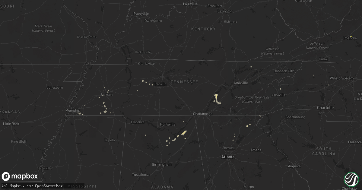
Hail Map in Tennessee on August 9, 2022
Get this storm
August 9 map
$229
one time, instant access
Download today. No call, no setup
Keep the $229
Bought the map and want the full workflow? Apply the entire $229 to a subscription within 7 days. None of it is wasted.
Every map, not just this one
This buys you this map. Subscription and you get every map we run, in the markets you choose from a few cities to whole states to nationwide. Plus real-time alerts the moment a storm fires.
Contact data
Name, contact info, occupancy, even credit band for addresses in the footprint. You go from where it hit to who to call.
Become the source they trust
Unlimited branding weather history reports on demand. You already have the documented answer ready for the property owner, and you are the one who showed up with it.
Property data and RoofTrace estimates
Pull up any address you have got, its value and the exact code rules for that jurisdiction, straight from One Click Code. Then RoofTrace estimates the squares, pitch, and roof value, priced the way you price.
Storm reports in Tennessee
Tennessee
| Date | Description |
|---|---|
| 08/09/20225:48 PM CDT | Trees and stop light down. |
| 08/09/20224:45 PM CDT | Several trees down across jefferson city... Talbott... And new market. |
| 08/09/20224:36 PM CDT | Several trees down. |
| 08/09/20224:10 PM CDT | Several trees down. |
| 08/09/20223:45 PM CDT | Several trees reported blown down between whitesburg... Tn and bulls gap... Tn. |
| 08/09/20223:10 PM CDT | Numerous trees were blown down including the highway 68 and highway 27 intersection... And also tom garrison road in the wolf creek area. |
| 08/09/20221:43 PM CDT | Trees down. |
| 08/09/20221:20 AM CDT | At 619 PM EDT, a severe thunderstorm was located over Tazewell, or 12 miles north of Rutledge, moving north at 10 mph. HAZARD...60 mph wind gusts and penny size hail. SOURCE...Radar indicated. IMPACT...Expect damage to roofs, siding, and trees. Locations impacted include... New Tazewell, Tazewell, Harrogate, Lone Mountain, Howard Quarter, Cumberland Gap, Ewing, Arthur and Powell River Preserve. |
| 08/09/202212:27 AM CDT | At 527 PM EDT, a severe thunderstorm was located over Jefferson City, moving northeast at 5 mph. HAZARD...60 mph wind gusts. SOURCE...Radar indicated. IMPACT...Expect damage to roofs, siding, and trees. Locations impacted include... Morristown, Jefferson City, Dandridge, White Pine, New Market, Panther Creek State Park and Alpha.This includes Interstate 81 in Tennessee between mile markers 5 and7. |
| 08/09/202212:20 AM CDT | At 519 PM EDT, a severe thunderstorm was located near Oak Ridge, moving east at 10 mph. HAZARD...60 mph wind gusts. SOURCE...Radar indicated. IMPACT...Expect damage to roofs, siding, and trees. Locations impacted include... Knoxville, Oak Ridge, Clinton, Lenoir City, Alcoa, Farragut, Louisville, Bearden, Powell and Karns.This includes the following highways... Interstate 40 in Tennessee between mile markers 362 and 387. Interstate 75 in Tennessee between mile markers 83 and 117. |
| 08/08/202211:57 PM CDT | At 457 PM CDT, a severe thunderstorm was located near Lebanon, moving northeast at 20 mph. HAZARD...60 mph wind gusts. SOURCE...Radar indicated. IMPACT...Expect damage to roofs, siding, and trees. Locations impacted include... Lebanon, Mount Juliet, Belinda City, Tuckers Crossroads, Dickerson Chapel Recreation Area and Gladeville.This includes the following highways... Interstate 40 between mile markers 228 and 245. Interstate 840 between mile markers 70 and 76. |
| 08/08/202211:42 PM CDT | At 441 PM CDT, a severe thunderstorm was located over Belinda City, or 8 miles west of Lebanon, moving northeast at 20 mph. HAZARD...60 mph wind gusts. SOURCE...Radar indicated. IMPACT...Expect damage to roofs, siding, and trees. Locations impacted include... Lebanon, Mount Juliet, Belinda City, Rural Hill, Gladeville and Green Hill.This includes the following highways... Interstate 40 between mile markers 224 and 244. Interstate 840 between mile markers 67 and 76. |
| 08/08/202211:29 PM CDT | At 428 PM EDT, a severe thunderstorm was located over Russellville, or 8 miles east of Morristown, moving northeast at 10 mph. HAZARD...60 mph wind gusts and penny size hail. SOURCE...Radar indicated. IMPACT...Expect damage to roofs, siding, and trees. Locations impacted include... Morristown, Russellville, Mosheim, Bulls Gap, St. Clair, Lowland and Romeo.This includes Interstate 81 in Tennessee between mile markers 10 and30. |
| 08/08/202211:25 PM CDT | At 424 PM EDT, severe thunderstorms were located along a line extending from 7 miles southeast of Spring City to 6 miles north of Charleston, moving northeast at 5 mph. HAZARD...60 mph wind gusts and penny size hail. SOURCE...Radar indicated. IMPACT...Expect damage to roofs, siding, and trees. Locations impacted include... Athens, Sweetwater, Decatur, Niota, Riceville, Peakland, Clear Water, Hillsview, Murray Store and Ten Mile.This includes Interstate 75 in Tennessee between mile markers 39 and60. |
| 08/08/202210:57 PM CDT | At 357 PM EDT, severe thunderstorms were located along a line extending from Rockwood to 6 miles south of Spring City to 8 miles northeast of Soddy-Daisy, and are nearly stationary. HAZARD...60 mph wind gusts. SOURCE...Radar indicated. IMPACT...Expect damage to roofs, siding, and trees. Locations impacted include... Dayton, Kingston, Rockwood, Decatur, Soddy-Daisy, Fairview, Spring City, Midtown, Harriman and Graysville.This includes Interstate 40 in Tennessee between mile markers 341 and343, and between mile markers 354 and 355, and near mile marker 357. |
All States Impacted by Hail Map on August 9, 2022
Cities Impacted by Hail Map on August 9, 2022
- Chickasha, OK
- Middleton, TN
- Saulsbury, TN
- Jackson, TN
- Denmark, TN
- Kaw City, OK
- Union City, TN
- Piedmont, OK
- Fargo, OK
- Buffalo, OK
- Fort Supply, OK
- Collierville, TN
- Lawton, OK
- Tryon, OK
- Chandler, OK
- Cushing, OK
- Stroud, OK
- Agra, OK
- Paden, OK
- Carney, OK
- Depew, OK
- Bolivar, TN
- Dawsonville, GA
- Batesville, MS
- Marlow, OK
- Rush Springs, OK
- Okarche, OK
- Many, LA
- Robeline, LA
- Marthaville, LA
- Fyffe, AL
- Groveoak, AL
- Guthrie, OK
- Greenville, FL
- Laverne, OK
- Ponca City, OK
- El Paso, TX
- Hamlin, TX
- Riceville, TN
- Albany, OR
- Lebanon, OR
- Scio, OR
- Thomas, OK
- Edmond, OK
- Stillwater, OK
- Perry, OK
- Lexington, TN
- Dallas, TX
- Sweet Home, OR
- Crabtree, OR
- Foster, OR
- Jefferson, OR
- Hamburg, AR
- Bend, OR
- Sautee Nacoochee, GA
- Tucson, AZ
- Mooreland, OK
- Tazewell, TN
- Cleo Springs, OK
- Clinton, AR
- Portland, AR
- Lake Village, AR
- Rockholds, KY
- Spring City, TN
- Brooksville, FL
- Kirkland, AZ
- Congress, AZ
- Lockney, TX
- Custer City, OK
- Lookeba, OK
- Hinton, OK
- Baxley, GA
- Hornsby, TN
- La Pine, OR
- Ringwood, OK
- Arab, AL
- Decatur, TN
- Apache, OK
- Sardis, MS
- Tiplersville, MS
- Ashland, MS
- Falkner, MS
- Albertville, AL
- Horton, AL
- Guntersville, AL
- Evensville, TN
- Helena, OK
- Arnett, OK
- Perkins, OK
- Ninnekah, OK
- Pineville, KY
- Cement, OK
- Lubbock, TX
- Centerville, TN
- Memphis, TN
- Copeland, KS
- Meno, OK
- Leesville, LA
- Weaverville, NC
- Barnardsville, NC
- Bon Aqua, TN
- Lyles, TN
- Statesville, NC
- Humboldt, TN
- Brownsville, TN
- Cashion, OK
- Greenwood, MS
- Coila, MS
- Sidon, MS
- Blountsville, AL
- Jacksboro, TX
- Tuttle, OK
- Summer Lake, OR
- Clayton, GA
- Germantown, TN
- Arlington, TN
- Booneville, MS
- Goltry, OK
- Moulton, AL
- La Mesa, NM
- Tallahassee, FL
- Stockton, GA
- Pampa, TX
- Mclean, TX
- Roanoke, VA
- Cullman, AL
- Holly Pond, AL
- Elgin, OK
- Fort Sill, OK
- Fort Bidwell, CA
- Lake City, CA
- Crossville, AL
- Sunflower, MS
- Tolar, TX
- Granbury, TX
- Ramer, TN
- Section, AL
- Clarkesville, GA
- Shattuck, OK
- Woodward, OK
- McCool, MS
- Louisville, MS
- Williamsburg, KY
- Milford, UT
- Ten Mile, TN
- Athens, TN
- Calhoun, TN
- Dickson, TN
- Nettleton, MS
- Indianola, MS
- Lillington, NC
- Angier, NC
- Hornbeck, LA
- Medina, TN
- Oakfield, TN
- Allenhurst, GA
- Ludowici, GA
- Cleveland, GA
- Purlear, NC
- Aubrey, TX
- Stephenville, TX
- Rio Rico, AZ
- Lewisburg, KY
- Russellville, KY
- Elkton, KY
- Amber, OK
- Yukon, OK
- Lancaster, TX
- Ralls, TX
- Ainsworth, NE
- Cherry Log, GA
- El Reno, OK
- Anthony, NM
- Anthony, TX
- Sayre, OK
- Likely, CA
- Perry, FL
- Primm Springs, TN
- Franklin, TN
- Calico Rock, AR
- Doddsville, MS
- Geary, OK
- Fay, OK
- Mountain Rest, SC
- Fackler, AL
- Hollywood, AL
- Hermitage, AR
- Post, TX
- Medon, TN
- Toone, TN
- Coffeeville, MS
- Oakland, MS
- Dawson, AL
- Cumming, GA
- Silver Lake, OR
- Eugene, OR


