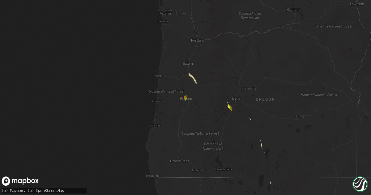
Hail Map on August 9, 2022
Get this storm
August 9 map
$229
one time, instant access
Download today. No call, no setup
Keep the $229
Bought the map and want the full workflow? Apply the entire $229 to a subscription within 7 days. None of it is wasted.
Every map, not just this one
This buys you this map. Subscription and you get every map we run, in the markets you choose from a few cities to whole states to nationwide. Plus real-time alerts the moment a storm fires.
Contact data
Name, contact info, occupancy, even credit band for addresses in the footprint. You go from where it hit to who to call.
Become the source they trust
Unlimited branding weather history reports on demand. You already have the documented answer ready for the property owner, and you are the one who showed up with it.
Property data and RoofTrace estimates
Pull up any address you have got, its value and the exact code rules for that jurisdiction, straight from One Click Code. Then RoofTrace estimates the squares, pitch, and roof value, priced the way you price.
States Impacted by Hail Map on August 9, 2022
Storm reports
Virginia
| Date | Description |
|---|---|
| 08/09/20225:15 PM CDT | Tree fell across road. |
| 08/09/20225:13 PM CDT | Tree fell across powerline and the road. |
| 08/09/20225:10 PM CDT | Nickel to quarter size hail observed at the waning point. Power went out briefly. Frequent lightning also observed. Aep indicates upwards of 2000 customers without powe |
| 08/09/20225:08 PM CDT | Powerlines down. Tree blown against powerline. |
| 08/09/20225:00 PM CDT | Tree across road. |
| 08/09/20221:04 AM CDT | At 603 PM EDT, a severe thunderstorm was located over Cloverdale, or near Vinton, moving east at 10 mph. HAZARD...60 mph wind gusts and quarter size hail. SOURCE...Radar indicated. IMPACT...Hail damage to vehicles is expected. Expect wind damage to roofs, siding, and trees. Locations impacted include... Roanoke... Vinton... Stewartsville... Montvale... Laymantown... Hollins... and Blue Ridge. |
| 08/08/20229:25 PM CDT | At 224 PM EDT, a severe thunderstorm was located over Lambsburg, or near Cana, moving southeast at 5 mph. HAZARD...60 mph wind gusts and quarter size hail. Very heavy rainfall. SOURCE...Radar indicated. IMPACT...Hail damage to vehicles is expected. Expect wind damage to roofs, siding, and trees. Flooding from very heavy rainfall. Locations impacted include... Mount Airy... Flat Rock... Fancy Gap... Bottom... Cana... Pine Ridge... and Toast. |
North Carolina
| Date | Description |
|---|---|
| 08/09/20223:10 PM CDT | Several tree limbs were blown down in the area. |
| 08/09/20223:10 PM CDT | 911 call center reported a tree blocking the roadway on dillingham road. |
| 08/09/20223:00 PM CDT | 911 call center reported a tree blocking roadway on barnardsville hwy. |
| 08/09/20221:24 AM CDT | At 624 PM EDT, a severe thunderstorm was located 11 miles northwest of Spartanburg, or near Lake Bowen, moving northeast at 15 mph. HAZARD...60 mph wind gusts and nickel size hail. SOURCE...Radar indicated. IMPACT...Expect damage to trees and power lines. Locations impacted include... Boiling Springs SC, Inman, Mayo, Chesnee, Cowpens National Battlefield, Lake Bowen, Cliffside, Henrietta, Harris and Green Creek. |
| 08/09/202212:11 AM CDT | At 511 PM EDT, a severe thunderstorm was located near Angier, or near Lillington, moving northeast at 15 mph. HAZARD...60 mph wind gusts. SOURCE...Radar indicated. IMPACT...Expect damage to roofs, siding, and trees. Locations impacted include... Lillington, Angier, Coats and Buies Creek. |
| 08/09/202212:08 AM CDT | At 507 PM EDT, a severe thunderstorm was located near Athens, moving east at 10 mph. HAZARD...60 mph wind gusts and penny size hail. SOURCE...Radar indicated. IMPACT...Expect damage to roofs, siding, and trees. Locations impacted include... Athens, Sweetwater, Madisonville, Etowah, Charleston, Englewood, Niota, Calhoun, Riceville and Clear Water.This includes Interstate 75 in Tennessee between mile markers 30 and57. |
| 08/08/202210:55 PM CDT | At 355 PM EDT, a severe thunderstorm was located 11 miles southwest of Burnsville, or 7 miles north of B.R. Parkway-East Asheville To Craggy Gardens, moving northeast at 20 mph. HAZARD...60 mph wind gusts and penny size hail. SOURCE...Radar indicated. IMPACT...Expect damage to trees and power lines. Locations impacted include... Burnsville, Mount Mitchell State Park, Micaville, Green Mountain, Barnardsville, Celo, B.R. Parkway-East Asheville To Craggy Gardens and B.R. Parkway-Craggy To Little Switzerland. |
Massachusetts
| Date | Description |
|---|---|
| 08/09/20222:57 PM CDT | Corrects previous tstm wnd dmg report from duxbury. Large tree on wires on flint locke drive. Time estimated by radar. |
| 08/09/20222:38 PM CDT | Large tree on wires on flint locke road. |
| 08/09/20222:36 PM CDT | In scituate... A tree and wires were down on beaver dam road. |
| 08/08/202210:43 PM CDT | At 343 PM EDT, a severe thunderstorm was located over Duxbury, or near Marshfield, moving east at 20 mph. HAZARD...60 mph wind gusts. SOURCE...Radar indicated. IMPACT...Expect damage to trees and power lines. Locations impacted include... Plymouth, Weymouth, Bridgewater, Marshfield, Middleborough, Hingham, Scituate, Pembroke, Rockland, Abington, Duxbury, Whitman, Hanover, East Bridgewater, Kingston, Carver, Norwell, Hanson, Halifax and Plympton. |
| 08/08/202210:12 PM CDT | At 311 PM EDT, a severe thunderstorm was located over Marshfield, moving east at 10 mph. HAZARD...60 mph wind gusts. SOURCE...Radar indicated. IMPACT...Expect damage to trees and power lines. Locations impacted include... Marshfield, Scituate, Pembroke, Duxbury, Hanover and Norwell. |
Tennessee
| Date | Description |
|---|---|
| 08/09/20225:48 PM CDT | Trees and stop light down. |
| 08/09/20224:45 PM CDT | Several trees down across jefferson city... Talbott... And new market. |
| 08/09/20224:36 PM CDT | Several trees down. |
| 08/09/20224:10 PM CDT | Several trees down. |
| 08/09/20223:45 PM CDT | Several trees reported blown down between whitesburg... Tn and bulls gap... Tn. |
| 08/09/20223:10 PM CDT | Numerous trees were blown down including the highway 68 and highway 27 intersection... And also tom garrison road in the wolf creek area. |
| 08/09/20221:43 PM CDT | Trees down. |
| 08/09/20221:20 AM CDT | At 619 PM EDT, a severe thunderstorm was located over Tazewell, or 12 miles north of Rutledge, moving north at 10 mph. HAZARD...60 mph wind gusts and penny size hail. SOURCE...Radar indicated. IMPACT...Expect damage to roofs, siding, and trees. Locations impacted include... New Tazewell, Tazewell, Harrogate, Lone Mountain, Howard Quarter, Cumberland Gap, Ewing, Arthur and Powell River Preserve. |
| 08/09/202212:27 AM CDT | At 527 PM EDT, a severe thunderstorm was located over Jefferson City, moving northeast at 5 mph. HAZARD...60 mph wind gusts. SOURCE...Radar indicated. IMPACT...Expect damage to roofs, siding, and trees. Locations impacted include... Morristown, Jefferson City, Dandridge, White Pine, New Market, Panther Creek State Park and Alpha.This includes Interstate 81 in Tennessee between mile markers 5 and7. |
| 08/09/202212:20 AM CDT | At 519 PM EDT, a severe thunderstorm was located near Oak Ridge, moving east at 10 mph. HAZARD...60 mph wind gusts. SOURCE...Radar indicated. IMPACT...Expect damage to roofs, siding, and trees. Locations impacted include... Knoxville, Oak Ridge, Clinton, Lenoir City, Alcoa, Farragut, Louisville, Bearden, Powell and Karns.This includes the following highways... Interstate 40 in Tennessee between mile markers 362 and 387. Interstate 75 in Tennessee between mile markers 83 and 117. |
| 08/08/202211:57 PM CDT | At 457 PM CDT, a severe thunderstorm was located near Lebanon, moving northeast at 20 mph. HAZARD...60 mph wind gusts. SOURCE...Radar indicated. IMPACT...Expect damage to roofs, siding, and trees. Locations impacted include... Lebanon, Mount Juliet, Belinda City, Tuckers Crossroads, Dickerson Chapel Recreation Area and Gladeville.This includes the following highways... Interstate 40 between mile markers 228 and 245. Interstate 840 between mile markers 70 and 76. |
| 08/08/202211:42 PM CDT | At 441 PM CDT, a severe thunderstorm was located over Belinda City, or 8 miles west of Lebanon, moving northeast at 20 mph. HAZARD...60 mph wind gusts. SOURCE...Radar indicated. IMPACT...Expect damage to roofs, siding, and trees. Locations impacted include... Lebanon, Mount Juliet, Belinda City, Rural Hill, Gladeville and Green Hill.This includes the following highways... Interstate 40 between mile markers 224 and 244. Interstate 840 between mile markers 67 and 76. |
| 08/08/202211:29 PM CDT | At 428 PM EDT, a severe thunderstorm was located over Russellville, or 8 miles east of Morristown, moving northeast at 10 mph. HAZARD...60 mph wind gusts and penny size hail. SOURCE...Radar indicated. IMPACT...Expect damage to roofs, siding, and trees. Locations impacted include... Morristown, Russellville, Mosheim, Bulls Gap, St. Clair, Lowland and Romeo.This includes Interstate 81 in Tennessee between mile markers 10 and30. |
| 08/08/202211:25 PM CDT | At 424 PM EDT, severe thunderstorms were located along a line extending from 7 miles southeast of Spring City to 6 miles north of Charleston, moving northeast at 5 mph. HAZARD...60 mph wind gusts and penny size hail. SOURCE...Radar indicated. IMPACT...Expect damage to roofs, siding, and trees. Locations impacted include... Athens, Sweetwater, Decatur, Niota, Riceville, Peakland, Clear Water, Hillsview, Murray Store and Ten Mile.This includes Interstate 75 in Tennessee between mile markers 39 and60. |
| 08/08/202210:57 PM CDT | At 357 PM EDT, severe thunderstorms were located along a line extending from Rockwood to 6 miles south of Spring City to 8 miles northeast of Soddy-Daisy, and are nearly stationary. HAZARD...60 mph wind gusts. SOURCE...Radar indicated. IMPACT...Expect damage to roofs, siding, and trees. Locations impacted include... Dayton, Kingston, Rockwood, Decatur, Soddy-Daisy, Fairview, Spring City, Midtown, Harriman and Graysville.This includes Interstate 40 in Tennessee between mile markers 341 and343, and between mile markers 354 and 355, and near mile marker 357. |
Alabama
| Date | Description |
|---|---|
| 08/09/20224:30 PM CDT | Tree down blocking road along springville blvd near hickory ridge road. Time estimated by radar. Winds likely sub-severe. |
| 08/09/20224:00 PM CDT | Trees blown down along cr 55 north of blountsville. |
| 08/09/20223:34 PM CDT | Corrects time on previous tstm wnd dmg report from 2 nne blountsville. Trees blown down along cr 55 north of blountsville. Time estimated by radar. |
| 08/09/20221:42 PM CDT | Trees reported snapped or uprooted along county road 43 near section. Time estimated by radar. |
| 08/09/20221:24 PM CDT | Trees reported down near geraldine. Time estimated by radar. |
| 08/09/202212:54 PM CDT | Trees snapped or uprooted along county road 162 near pisgah. Time estimated by radar. |
| 08/09/202212:48 PM CDT | Trees reported down in the deans chapel community. Time estimated by radar. |
| 08/08/20229:16 PM CDT | At 216 PM CDT, a severe thunderstorm was located near Guntersville, moving southwest at 10 mph. HAZARD...60 mph wind gusts and penny size hail. SOURCE...Radar indicated. IMPACT...Expect damage to roofs, siding, and trees. Locations impacted include... Albertville, Guntersville, Douglas, Union Grove, High Point, Hustleville, Rabbit Town, Columbus City, Hyatt and Mountain View. |
| 08/08/20228:41 PM CDT | At 141 PM CDT, a severe thunderstorm was located near Geraldine, or 12 miles southwest of Rainsville, moving northeast at 15 mph. HAZARD...60 mph wind gusts and nickel size hail. SOURCE...Radar indicated. IMPACT...Expect damage to roofs, siding, and trees. Locations impacted include... Scottsboro, Rainsville, Sylvania, Fyffe, Powell, Geraldine, Section, Dutton, Langston and Lakeview. |
Nevada
| Date | Description |
|---|---|
| 08/09/20226:39 PM CDT | Mesonet station rbtn2 red butte raws station elevation: 5025 ft. |
| 08/09/202212:51 AM CDT | At 550 PM PDT, a severe thunderstorm was located 8 miles southeast of Silver Springs, or 9 miles south of Lahontan Reservoir, moving north at 25 mph. HAZARD...60 mph wind gusts and half dollar size hail. SOURCE...Radar indicated. IMPACT...Hail damage to vehicles is expected. Expect wind damage to roofs, siding, fencing and trees. Locations impacted include... Lahontan Reservoir, Fernley, Hazen, Silver Springs and Us 50 At Lyon-Churchill Co Line. |
| 08/09/202212:18 AM CDT | At 517 PM PDT/517 PM MST/, a severe thunderstorm was located over South Cove, or 34 miles southeast of Overton, moving northwest at 20 mph. HAZARD...40-50 mph wind gusts on the lake. Hazardous boating conditions. SOURCE...Radar indicated. IMPACT...Expect damage to roofs and trees. Hazardous boating conditions due to enhanced wave activity. Locations impacted include... Echo Bay, Lake Mead National Recreation Area, Temple Bar Campground, Overton Beach, Echo Bay Campground, South Cove, Meadview and Temple Bar. |
| 08/08/20229:12 PM CDT | At 211 PM PDT, a line of severe thunderstorm was located near Pioche through Ursine, moving northwest at 15 mph. HAZARD...60 mph wind gusts and pea size hail. SOURCE...Radar indicated. IMPACT...Expect damage to roofs and trees. Locations impacted include... Ursine, Pioche, Ranch Campground, Horsethief Gulch Campground, Eagle Valley, Meadow Valley Campground, Panaca, Echo Canyon State Park and Cathedral Gorge State Park. |
| 08/08/20227:21 PM CDT | Mesonet station up984 9.7 nw valmy |
Oregon
| Date | Description |
|---|---|
| 08/09/20226:45 PM CDT | Tree fell on home. Time estimated from radar. |
| 08/09/20226:30 PM CDT | Downed trees. Power outages. Time estimated from radar. |
| 08/09/20224:55 PM CDT | Sheriff relayed reports from public regarding a couple of hay barns collapsing from the winds. Time estimated from radar. |
| 08/09/20223:25 AM CDT | At 824 PM PDT, a severe thunderstorm was located near Scio, or 9 miles east of Albany, moving northwest at 35 mph. HAZARD...Quarter size hail. SOURCE...Radar indicated. IMPACT...Damage to vehicles is expected. Locations impacted include... Salem, Albany, Monmouth, Independence, Jefferson, Turner, Scio, Four Corners, Marion, Aumsville, Millersburg, Crabtree and Buena Vista. |
| 08/09/20222:56 AM CDT | At 756 PM PDT, a severe thunderstorm was located near Sweet Home, moving north-northwest at 35 mph. HAZARD...Quarter size hail. SOURCE...Radar indicated. IMPACT...Damage to vehicles is expected. Locations impacted include... Sweet Home, Lebanon, Lacomb, South Lebanon, Sodaville, Waterloo, Holley, Crabtree and Foster Reservoir. |
| 08/09/20222:53 AM CDT | At 752 PM PDT, a severe thunderstorm was located 11 miles northeast of Paisley, or 43 miles north of Lakeview, moving north at 45 mph. HAZARD...60 mph wind gusts and quarter size hail. SOURCE...Radar indicated. IMPACT...Hail damage to vehicles is expected. Expect wind damage to roofs, siding, and trees. This severe thunderstorm will remain over mainly rural areas of central Lake County. |
| 08/09/202212:07 AM CDT | At 505 PM PDT, a severe thunderstorm was located 16 miles south of McKenzie Pass, or 22 miles west of Bend, moving northwest at 40 mph. HAZARD...60 mph wind gusts and quarter size hail. SOURCE...Radar indicated. IMPACT...Hail damage to vehicles is expected. Expect wind damage to roofs, siding, and trees. Locations impacted include... McKenzie Pass, Belknap Springs and the Three Sisters. |
| 08/08/202211:45 PM CDT | In direct comparison to a quarter via social media photo...was clearly wider than the quarter. |
| 08/08/202211:43 PM CDT | At 442 PM PDT, a severe thunderstorm was located near Three Rivers, or 14 miles north of La Pine, moving northwest at 40 mph. HAZARD...60 mph wind gusts and half dollar size hail. SOURCE...Radar indicated. IMPACT...Hail damage to vehicles is expected. Expect wind damage to roofs, siding, and trees. Locations impacted include... Three Rivers and Sunriver. |
| 08/08/202211:40 PM CDT | Spotter found a hailstone that was 1 inch in length. |
| 08/08/202211:30 PM CDT | Average of 2.7 centimeter in diameter. |
Oklahoma
| Date | Description |
|---|---|
| 08/09/20226:20 PM CDT | A local report indicates 1.00 inch wind near 4 S GUTHRIE |
| 08/09/20226:15 PM CDT | A local report indicates 60 MPH wind near 4 NW CHICKASHA |
| 08/09/20226:02 PM CDT | Power pole downed. |
| 08/09/20224:42 PM CDT | Minor wind damage also. |
| 08/09/20224:11 AM CDT | At 911 PM CDT, a severe thunderstorm was located over Stroud, moving east at 20 mph. HAZARD...60 mph wind gusts and half dollar size hail. SOURCE...Radar indicated. IMPACT...Hail damage to vehicles is expected. Expect wind damage to roofs, siding, and trees. Locations in or near the path include... Bristow... Depew... Milfay... This includes Interstate 44 between mile markers 178 and 191. |
| 08/09/20224:02 AM CDT | At 902 PM CDT, a severe thunderstorm was located near Kendrick, moving southeast at 10 mph. HAZARD...60 mph wind gusts and quarter size hail. SOURCE...Radar indicated. IMPACT...Hail damage to vehicles is expected. Expect wind damage to roofs, siding, and trees. Locations impacted include... Chandler, Stroud, Davenport, Kendrick and Avery. |
| 08/09/20221:58 AM CDT | At 658 PM CDT, a severe thunderstorm was located near Alex, and is nearly stationary. HAZARD...60 mph wind gusts and penny size hail. SOURCE...Radar indicated. IMPACT...Expect damage to roofs, siding, and trees. Locations impacted include... Alex, Bradley and Tabler. |
| 08/09/20221:43 AM CDT | At 643 PM CDT, severe thunderstorms were located along a line extending from near Fort Sill to 5 miles west of Geronimo, and are nearly stationary. HAZARD...60 mph wind gusts and quarter size hail. SOURCE...Radar indicated. IMPACT...Hail damage to vehicles is expected. Expect wind damage to roofs, siding, and trees. Locations impacted include... Lawton, Geronimo, Medicine Park, Faxon, eastern Fort Sill and Lake Lawtonka. |
| 08/09/202212:51 AM CDT | At 551 PM CDT, a severe thunderstorm was located 5 miles south of Cedar Valley, moving west at 5 mph. HAZARD...70 mph wind gusts and half dollar size hail. SOURCE...Radar indicated. IMPACT...Hail damage to vehicles is expected. Expect considerable tree damage. Wind damage is also likely to mobile homes, roofs, and outbuildings. Locations impacted include... Cashion, Cedar Valley, Cimarron City and Navina. |
| 08/09/202212:03 AM CDT | At 503 AM CDT, a severe thunderstorm was located over Crowder, and is nearly stationary. HAZARD...60 mph wind gusts and quarter size hail. SOURCE...Radar indicated. IMPACT...Hail damage to vehicles is expected. Expect wind damage to roofs, siding, and trees. Locations in or near the path include... Crowder... Canadian... Arrowhead State Park... |
| 08/08/202211:38 PM CDT | At 438 PM CDT, a severe thunderstorm was located near Ponca City, moving south at 10 mph. HAZARD...60 mph wind gusts and penny size hail. SOURCE...Radar indicated. IMPACT...Expect damage to roofs, siding, and trees. Locations impacted include... Ponca City, Kaw City and southwestern Kaw Lake. |
| 08/08/202211:12 PM CDT | At 412 PM CDT, a severe thunderstorm was located 5 miles southeast of Thomas, moving west at 10 mph. HAZARD...60 mph wind gusts and quarter size hail. SOURCE...Radar indicated. IMPACT...Hail damage to vehicles is expected. Expect wind damage to roofs, siding, and trees. Locations impacted include... Thomas and Custer City. |
| 08/08/20228:05 PM CDT | Acme site. |
| 08/08/20227:15 PM CDT | A local report indicates 1.00 inch wind near 2 SSW FORT SILL |
Arizona
| Date | Description |
|---|---|
| 08/09/20225:42 PM CDT | Trained spotter reports a 20 foot palo verde tree and a mesquite tree fallen over in the neighborhood. Pea size hail fell in the area. |
| 08/09/20225:35 PM CDT | Power poles down on linda vista blvd between bald eagle ave and waterbuck dr. |
| 08/09/20222:59 PM CDT | Reported from wunderground location kazkirkl6. |
| 08/09/20227:46 AM CDT | At 1246 PM MST, a severe thunderstorm was located 7 miles east of Quartzsite, or 35 miles south of Parker, moving north at 5 mph. HAZARD...60 mph wind gusts. SOURCE...Radar indicated. IMPACT...Expect damage to roofs, siding, and trees. Locations impacted include... Quartzsite.This includes the following highways...AZ Interstate 10 between mile markers 18 and 33.US Highway 60 between mile markers 31 and 33.AZ Route 95 between mile markers 99 and 117. |
| 08/09/20227:31 AM CDT | At 1230 PM MST, a severe thunderstorm was located between Kirkland and Peeples Valley, moving north at 15 mph. HAZARD...60 mph wind gusts and quarter size hail. SOURCE...Radar indicated. IMPACT...Hail damage to vehicles is expected. Expect wind damage to roofs, siding, and trees. Locations impacted include... Peeples Valley and Kirkland. |
| 08/09/20221:18 AM CDT | At 617 PM PDT/617 PM MST/, a severe thunderstorm was located 7 miles north of Temple Bar Campground, or 29 miles south of Overton, moving northwest at 5 mph. This warning replaces the previous Severe Thunderstorm Warning for Lake Mead. HAZARD...40-50 mph wind gusts on the lake. Hazardous boating conditions. SOURCE...Radar indicated. IMPACT...Expect damage to roofs and trees. Hazardous boating conditions due to enhanced wave activity. Locations impacted include... Echo Bay, Temple Bar Campground, Overton Beach, Echo Bay Campground, South Cove, Lake Mead National Recreation Area, Valley Of Fire and Temple Bar. |
| 08/09/20221:12 AM CDT | At 612 PM MST, a severe thunderstorm was located near Bowie, or 24 miles east of Willcox, moving west at 15 mph. HAZARD...60 mph wind gusts and quarter size hail. SOURCE...Radar indicated. IMPACT...Hail damage to vehicles is expected. Expect wind damage to roofs, siding, and trees. Locations impacted include... Bowie. |
| 08/08/202210:33 PM CDT | At 333 PM MST, a severe thunderstorm was located near Casas Adobes, or 7 miles southeast of Marana, moving north at 5 mph. HAZARD...60 mph wind gusts and quarter size hail. SOURCE...Radar indicated. IMPACT...Hail damage to vehicles is expected. Expect wind damage to roofs, siding, and trees. Locations impacted include... Tucson, Oro Valley, Marana, Casas Adobes, Flowing Wells, Tortolita, Saguaro National Park West, Catalina Foothills, Tucson Estates, Picture Rocks and Dove Mountain. |
| 08/08/20228:55 PM CDT | At 153 PM MST, a severe thunderstorm was located southeast of Yarnell, near Wagoner, or 16 miles northeast of Wickenburg, moving northwest at 10 mph. HAZARD...60 mph wind gusts, up to penny size hail, and heavy rainfall. SOURCE...Radar indicated. IMPACT...Expect damage to roofs, siding, and trees. Locations impacted include... Walnut Grove, Wagoner, Yarnell, and Peeples Valley. |
| 08/08/20227:25 PM CDT | At 525 pm the pierce ferry hads sensor recorded a gust of 60 mph. |
New Jersey
| Date | Description |
|---|---|
| 08/09/20221:29 AM CDT | At 628 PM EDT, severe thunderstorms were located along a line extending from Ridgewood to Union, moving east at 25 mph. HAZARD...60 mph wind gusts and quarter size hail. SOURCE...Radar indicated. IMPACT...Minor hail damage to vehicles is possible. Expect wind damage to trees and power lines. Locations impacted include... Newark, Jersey City, Paterson, Elizabeth, Passaic, Bayonne, Wayne, Mott Haven, Hoboken, Bloomfield, East Tremont, Hackensack, Orange, Bergenfield and Paramus. |
Maryland
| Date | Description |
|---|---|
| 08/09/20226:47 PM CDT | Numerous trees and wires blew down on the west side of frederick. Several trees and wires blew down knocking over a couple of poles and causing a transformer fire on ho |
| 08/09/20222:35 AM CDT | At 735 PM EDT, a severe thunderstorm was located near Braddock Heights, or 7 miles southwest of Harry Grove Stadium, moving east at 15 mph. HAZARD...60 mph wind gusts. SOURCE...Radar indicated. IMPACT...Damaging winds will cause some trees and large branches to fall. This could injure those outdoors, as well as damage homes and vehicles. Roadways may become blocked by downed trees. Localized power outages are possible. Unsecured light objects may become projectiles. Locations impacted include... Frederick, Harry Grove Stadium, Ballenger Creek, Brunswick, Walkersville, Braddock Heights, New Market, Clover Hill, Discovery-Spring Garden, Point Of Rocks, Linganore-Bartonsville, Adamstown, Jefferson, Myersville, Buckeystown, Libertytown, Monrovia, Rosemont, Burkittsville and Doubs. |
New York
| Date | Description |
|---|---|
| 08/08/202210:55 PM CDT | At 354 PM EDT, severe thunderstorms were located along a line extending from 8 miles north of Rocky Point to Farmingville, moving east at 30 mph. HAZARD...60 mph wind gusts and quarter size hail. SOURCE...Radar indicated. IMPACT...Minor hail damage to vehicles is possible. Expect wind damage to trees and power lines. Locations impacted include... Riverhead, Centereach, Manorville, Stony Brook, Middle Island, Port Jefferson, Wading River, Mattituck, Coram, Smithtown, Rocky Point, Mount Sinai, Calverton, Brookhaven National Laboratory and Selden. |
South Carolina
| Date | Description |
|---|---|
| 08/08/202210:24 PM CDT | At 323 PM EDT, a severe thunderstorm was located 12 miles northeast of Clayton, or 6 miles south of Highlands, moving northeast at 10 mph. HAZARD...60 mph wind gusts and penny size hail. SOURCE...Radar indicated. IMPACT...Expect damage to trees and power lines. Locations impacted include... Highlands, Cashiers, Mountain Rest, Bad Creek, Pine Mountain, Whiteside Mountain, Sapphire, Lake Jocassee and Lake Glenville. |
| 08/08/202210:23 PM CDT | At 322 PM EDT, a severe thunderstorm was located 7 miles northwest of Clarkesville, moving east at 15 mph. HAZARD...60 mph wind gusts and quarter size hail. SOURCE...Radar indicated. IMPACT...Minor hail damage to vehicles is expected. Expect wind damage to trees and power lines. Locations impacted include... Toccoa, Clarkesville, Tallulah Falls, Lake Rabun, Lakemont, Tallulah Gorge State Park, Hollywood, Long Creek, Batesville and Seed Lake. |
| 08/08/20229:43 PM CDT | At 243 PM EDT, a severe thunderstorm was located 13 miles northeast of Clayton, or near Highlands, moving northeast at 15 mph. HAZARD...60 mph wind gusts and quarter size hail. SOURCE...Radar indicated. IMPACT...Minor hail damage to vehicles is expected. Expect wind damage to trees and power lines. Locations impacted include... Highlands, Cashiers, Lake Glenville, Scaly Mountain and Whiteside Mountain. |
Florida
| Date | Description |
|---|---|
| 08/09/20224:20 PM CDT | Tree down on ne raintree ave. |
| 08/09/20223:40 PM CDT | Fallen trees or limbs resulted in a small power outage. |
| 08/09/20223:37 PM CDT | Fallen trees or limbs resulted in a small power outage. |
| 08/09/20222:30 PM CDT | Tree down on a power line partially blocking the road near alan a dale and joe cotton trail. |
| 08/09/20222:30 PM CDT | Large branches were blown down in the area of 3200 shannon lakes n. |
| 08/09/20221:22 AM CDT | At 622 PM EDT, a severe thunderstorm was located 8 miles west of Needmore, or 12 miles northeast of Jasper, moving north at 20 mph. HAZARD...60 mph wind gusts. SOURCE...Radar indicated. IMPACT...Expect damage to roofs, siding, and trees. This severe thunderstorm will remain over mainly rural areas of central Echols and west central Clinch Counties. |
| 08/09/202212:32 AM CDT | At 532 PM EDT, a severe thunderstorm was located 8 miles southwest of Lake Park, moving northeast at 15 mph. HAZARD...60 mph wind gusts. SOURCE...Radar indicated. IMPACT...Expect damage to roofs, siding, and trees. Locations impacted include... Lake Park, Valdosta, Hahira, I-75 At Exit 16, Remerton, Dasher, Twin Lakes, Cherry Lake, Pinetta, Valdosta Regional Airport, Kinderlou, I-75 At Exit 5, Nankin, I-75 At Exit 29, Clyattville, Blue Springs, Hanson, I-75 At Exit 22 and I-75 At Exit 11. |
| 08/08/202211:26 PM CDT | At 426 PM EDT, severe thunderstorms were located along a line extending from 10 miles northeast of Perry to 15 miles northwest of Steinhatchee, moving north at 15 mph. HAZARD...60 mph wind gusts. SOURCE...Radar indicated. IMPACT...Expect damage to roofs, siding, and trees. Locations impacted include... Perry, Pinland, Secotan, Boyd, Adams Beach, Lake Bird, Foley, Blue Springs, Perry-Foley Airport, Bucell Junction, Athena, Hampton Springs, Shady Grove and Fenholloway. |
| 08/08/202211:17 PM CDT | At 417 PM EDT, Doppler radar indicated a severe thunderstorm capable of producing damaging winds in excess of 60 mph. This storm was located 13 miles west of Madison, and moving northeast at 10 mph. Locations impacted include... Greenville, Hamburg and Ebb. |
| 08/08/202210:59 PM CDT | At 359 PM EDT, a severe thunderstorm was located near Pine Island, or 11 miles south of Homosassa Springs, moving northwest at 10 mph. HAZARD...60 mph wind gusts and quarter size hail. SOURCE...Radar indicated. IMPACT...Hail damage to vehicles is expected. Expect wind damage to roofs, siding, and trees. Locations impacted include... Chassahowitzka Refuge, Chassahowitzka and Homosassa. |
| 08/08/202210:28 PM CDT | At 328 PM EDT, a severe thunderstorm was located over New Port Richey East, or near New Port Richey, moving northwest at 35 mph. HAZARD...60 mph wind gusts and nickel size hail. SOURCE...Radar indicated. IMPACT...Expect damage to roofs, siding, and trees. Locations impacted include... Spring Hill, Clearwater, Safety Harbor, New Port Richey, Oldsmar, Palm Harbor, Jasmine Estates, Trinity, New Port Richey East and Shady Hills. |
| 08/08/202210:24 PM CDT | At 324 PM EDT, a severe thunderstorm was located near Tallahassee, moving north at 10 mph. HAZARD...60 mph wind gusts. SOURCE...Radar indicated. IMPACT...Expect damage to roofs, siding, and trees. Locations impacted include... Tallahassee, Moccasin Gap, Killearn Estates, Lake Iamonia, Bradfordville, Maclay State Gardens, Killearn Lakes, Iamonia, Pisgah Church and Miccosukee. |
| 08/08/20229:58 PM CDT | At 258 PM EDT, a severe thunderstorm was located over Greater Northdale, or near Lutz, moving northwest at 35 mph. HAZARD...60 mph wind gusts. SOURCE...Radar indicated. IMPACT...Expect damage to roofs, siding, and trees. Locations impacted include... New Port Richey, Oldsmar, Jasmine Estates, Trinity, Westchase, New Port Richey East, Elfers, Hudson, Citrus Park and Greater Carrollwood. |
Kentucky
| Date | Description |
|---|---|
| 08/09/20226:55 PM CDT | Reports of trees down across ky-36. |
| 08/09/20225:30 PM CDT | Several trees downed in the new concord area... Some of which caused power line damage. |
| 08/09/20221:58 PM CDT | One tree down near the 2700 block of louden-meadow creek road. |
| 08/09/20221:45 PM CDT | Late report. Several large trees uprooted. Large branches down. A few miles north of elkton near town of claymour. |
| 08/08/20229:52 PM CDT | At 252 PM EDT, a severe thunderstorm was located over Perkins, or 7 miles northeast of Williamsburg, moving east at 20 mph. HAZARD...60 mph wind gusts. SOURCE...Radar indicated. IMPACT...Expect damage to roofs, siding, and trees. This severe thunderstorm will be near... Permon around 305 PM EDT. King around 310 PM EDT.Other locations in the path of this severe thunderstorm includeSwanpond, Barbourville and Boone Heights. |
Indiana
| Date | Description |
|---|---|
| 08/08/20227:09 PM CDT | Siding off a building and reports of a couple of trees down. |
Louisiana
| Date | Description |
|---|---|
| 08/09/20221:15 AM CDT | At 614 PM CDT, a severe thunderstorm was located near Slagle, moving southeast at 25 mph. HAZARD...60 mph wind gusts. SOURCE...Radar indicated. IMPACT...Expect damage to roofs, siding, and trees. Locations impacted include... Slagle, Hutton, Lacamp, Leander and Simpson. |
Georgia
| Date | Description |
|---|---|
| 08/09/20226:40 PM CDT | Report of trees down across highway 135 caused by thunderstorm. |
| 08/09/20226:15 PM CDT | Delayed report. A swath of thunderstorm wind damage was reported along axon road in atkinson county ga. Powerlines and trees were downed along with several damaged shed |
| 08/09/20225:55 PM CDT | Trees down along us 221 with a couple of transformers blown in the surrounding area. Time estimated by radar. |
| 08/09/20224:53 PM CDT | Tree down on murphy st. |
| 08/09/20224:50 PM CDT | Power line down on tucker rd. |
| 08/09/20224:50 PM CDT | Tree down on poplar st. |
| 08/09/20224:49 PM CDT | Tree down on sherwood road. |
| 08/09/20224:49 PM CDT | Tree down near intersection of bay ln and fred ln. |
| 08/09/20224:44 PM CDT | Tree down on 4-h club rd. |
| 08/09/20222:55 PM CDT | 911 call center reported tree blocking roadway on brandon mill road. |
| 08/09/20222:55 PM CDT | 911 call center reported trees fell on powerlines and blocking roadway on lake rabun road. |
| 08/09/20222:30 PM CDT | 911 call center reported trees fell on powerlines and blocking roadway on earls ford road. |
| 08/09/20222:15 PM CDT | Trees reported down on top of mt yonah. |
| 08/09/20222:25 AM CDT | At 725 PM EDT, severe thunderstorms were located along a line extending from near Ambrose to 7 miles west of Dixie Union, moving northeast at 35 mph. HAZARD...70 mph wind gusts. SOURCE...Radar indicated. IMPACT...Expect considerable tree damage. Damage is likely to mobile homes, roofs, and outbuildings. Locations impacted include... Douglas, Baxley, Hazlehurst, Alma, Broxton, Ambrose, Graham, Surrency, Plant Hatch and Nicholls. |
| 08/09/20222:02 AM CDT | At 702 PM EDT, severe thunderstorms were located along a line extending from 9 miles northeast of Alapaha to near Cogdell, moving northeast at 40 mph. HAZARD...60 mph wind gusts. SOURCE...Radar indicated. IMPACT...Expect damage to roofs, siding, and trees. Locations impacted include... Douglas, Alma, Pearson, Broxton, Ambrose, Nicholls, Pridgen, Snipesville, West Green and Denton. |
| 08/09/202212:56 AM CDT | At 556 PM EDT, a severe thunderstorm was located near Statenville, moving north at 20 mph. HAZARD...60 mph wind gusts. SOURCE...Radar indicated. IMPACT...Expect damage to roofs, siding, and trees. Locations impacted include... Statenville, Du Pont and Mayday. |
| 08/08/202211:46 PM CDT | At 446 PM EDT, a severe thunderstorm was located 11 miles southwest of Madison, moving north at 15 mph. HAZARD...60 mph wind gusts. SOURCE...Radar indicated. IMPACT...Expect damage to roofs, siding, and trees. Locations impacted include... Madison, Lee, Moseley Hall, Hopewell, Cherry Lake, Hamburg, Hanson and Pinetta. |
| 08/08/202211:04 PM CDT | At 403 PM EDT, a severe thunderstorm was located 7 miles northwest of Walhalla, or 4 miles southwest of Oconee State Park, moving east at 20 mph. HAZARD...60 mph wind gusts and penny size hail. SOURCE...Radar indicated. IMPACT...Expect damage to trees and power lines. Locations impacted include... Walhalla, Salem, Devils Fork State Park, Lake Keowee, Oconee State Park, Mountain Rest, Long Creek and Lake Jocassee. |
| 08/08/202210:10 PM CDT | At 310 PM EDT, a severe thunderstorm was located over Sautee, or near Cleveland, moving northeast at 15 mph. HAZARD...60 mph wind gusts and quarter size hail. SOURCE...Radar indicated. IMPACT...Hail damage to vehicles is expected. Expect wind damage to roofs, siding, and trees. Locations impacted include... Cleveland, Helen, Unicoi State Park, Robertstown, Anna Ruby Falls, Leaf, Smithgall Woods Conservation Are, Sautee and Qualatchee Lake. |
| 08/08/20229:25 PM CDT | At 225 PM EDT, a severe thunderstorm was located over Silver City, or near Dawsonville, moving northeast at 20 mph. HAZARD...60 mph wind gusts and quarter size hail. SOURCE...Radar indicated. IMPACT...Hail damage to vehicles is expected. Expect wind damage to roofs, siding, and trees. Locations impacted include... Cumming, Dawsonville, Dougherty, Matt, Silver City, Chestatee, Hollis Lathem Reservoir, Ducktown, Coal Mountain, Hightower, War Hill Park and McKee. |
| 08/08/20227:37 PM CDT | Trees and powerlines were reported down along old dairy road. |
Mississippi
| Date | Description |
|---|---|
| 08/08/202210:36 PM CDT | At 336 PM CDT, a severe thunderstorm was located near Canton, moving west at 5 mph. HAZARD...60 mph wind gusts and quarter size hail. SOURCE...Radar indicated. IMPACT...Hail damage to vehicles is expected. Expect wind damage to roofs, siding, and trees. This severe thunderstorm will be near... Canton and Gluckstadt around 415 PM CDT. |
Texas
| Date | Description |
|---|---|
| 08/09/20225:52 PM CDT | Time estimated from radar. Report from twitter. |
| 08/09/20225:42 PM CDT | A local report indicates 1.50 inch wind near 2 SSE CANUTILLO |
| 08/09/20225:40 PM CDT | Multiple 4-6 inch tree limbs down. |
| 08/09/20222:45 PM CDT | A local report indicates 61 MPH wind near 1 NE AMHERST |
| 08/08/202211:38 PM CDT | At 438 PM MDT, a severe thunderstorm was located near West El Paso, moving west at 10 mph. HAZARD...60 mph wind gusts and quarter size hail. SOURCE...Radar indicated. IMPACT...Hail damage to vehicles is expected. Expect wind damage to roofs, siding, and trees. Locations impacted include... West El Paso, Santa Teresa, Sunland Park, Canutillo, La Union, Vinton and Union Pacific Intermodal Terminal.This includes Interstate 10 in Texas between mile markers 4 and 12. |
Arkansas
| Date | Description |
|---|---|
| 08/08/20229:26 PM CDT | At 225 PM CDT, a severe thunderstorm was located near Hamburg, moving east at 10 mph. HAZARD...60 mph wind gusts and quarter size hail. SOURCE...Radar indicated. IMPACT...Hail damage to vehicles is expected. Expect wind damage to roofs, siding, and trees. This severe thunderstorm will be near... Snyder around 315 PM CDT. |
Cities Impacted by Hail Map on August 9, 2022
- Chickasha, OK
- Middleton, TN
- Saulsbury, TN
- Jackson, TN
- Denmark, TN
- Kaw City, OK
- Union City, TN
- Piedmont, OK
- Fargo, OK
- Buffalo, OK
- Fort Supply, OK
- Collierville, TN
- Lawton, OK
- Tryon, OK
- Chandler, OK
- Cushing, OK
- Stroud, OK
- Agra, OK
- Paden, OK
- Carney, OK
- Depew, OK
- Bolivar, TN
- Dawsonville, GA
- Batesville, MS
- Marlow, OK
- Rush Springs, OK
- Okarche, OK
- Many, LA
- Robeline, LA
- Marthaville, LA
- Fyffe, AL
- Groveoak, AL
- Guthrie, OK
- Greenville, FL
- Laverne, OK
- Ponca City, OK
- El Paso, TX
- Hamlin, TX
- Riceville, TN
- Albany, OR
- Lebanon, OR
- Scio, OR
- Thomas, OK
- Edmond, OK
- Stillwater, OK
- Perry, OK
- Lexington, TN
- Dallas, TX
- Sweet Home, OR
- Crabtree, OR
- Foster, OR
- Jefferson, OR
- Hamburg, AR
- Bend, OR
- Sautee Nacoochee, GA
- Tucson, AZ
- Mooreland, OK
- Tazewell, TN
- Cleo Springs, OK
- Clinton, AR
- Portland, AR
- Lake Village, AR
- Rockholds, KY
- Spring City, TN
- Brooksville, FL
- Kirkland, AZ
- Congress, AZ
- Lockney, TX
- Custer City, OK
- Lookeba, OK
- Hinton, OK
- Baxley, GA
- Hornsby, TN
- La Pine, OR
- Ringwood, OK
- Arab, AL
- Decatur, TN
- Apache, OK
- Sardis, MS
- Tiplersville, MS
- Ashland, MS
- Falkner, MS
- Albertville, AL
- Horton, AL
- Guntersville, AL
- Evensville, TN
- Helena, OK
- Arnett, OK
- Perkins, OK
- Ninnekah, OK
- Pineville, KY
- Cement, OK
- Lubbock, TX
- Centerville, TN
- Memphis, TN
- Copeland, KS
- Meno, OK
- Leesville, LA
- Weaverville, NC
- Barnardsville, NC
- Bon Aqua, TN
- Lyles, TN
- Statesville, NC
- Humboldt, TN
- Brownsville, TN
- Cashion, OK
- Greenwood, MS
- Coila, MS
- Sidon, MS
- Blountsville, AL
- Jacksboro, TX
- Tuttle, OK
- Summer Lake, OR
- Clayton, GA
- Germantown, TN
- Arlington, TN
- Booneville, MS
- Goltry, OK
- Moulton, AL
- La Mesa, NM
- Tallahassee, FL
- Stockton, GA
- Pampa, TX
- Mclean, TX
- Roanoke, VA
- Cullman, AL
- Holly Pond, AL
- Elgin, OK
- Fort Sill, OK
- Fort Bidwell, CA
- Lake City, CA
- Crossville, AL
- Sunflower, MS
- Tolar, TX
- Granbury, TX
- Ramer, TN
- Section, AL
- Clarkesville, GA
- Shattuck, OK
- Woodward, OK
- McCool, MS
- Louisville, MS
- Williamsburg, KY
- Milford, UT
- Ten Mile, TN
- Athens, TN
- Calhoun, TN
- Dickson, TN
- Nettleton, MS
- Indianola, MS
- Lillington, NC
- Angier, NC
- Hornbeck, LA
- Medina, TN
- Oakfield, TN
- Allenhurst, GA
- Ludowici, GA
- Cleveland, GA
- Purlear, NC
- Aubrey, TX
- Stephenville, TX
- Rio Rico, AZ
- Lewisburg, KY
- Russellville, KY
- Elkton, KY
- Amber, OK
- Yukon, OK
- Lancaster, TX
- Ralls, TX
- Ainsworth, NE
- Cherry Log, GA
- El Reno, OK
- Anthony, NM
- Anthony, TX
- Sayre, OK
- Likely, CA
- Perry, FL
- Primm Springs, TN
- Franklin, TN
- Calico Rock, AR
- Doddsville, MS
- Geary, OK
- Fay, OK
- Mountain Rest, SC
- Fackler, AL
- Hollywood, AL
- Hermitage, AR
- Post, TX
- Medon, TN
- Toone, TN
- Coffeeville, MS
- Oakland, MS
- Dawson, AL
- Cumming, GA
- Silver Lake, OR
- Eugene, OR