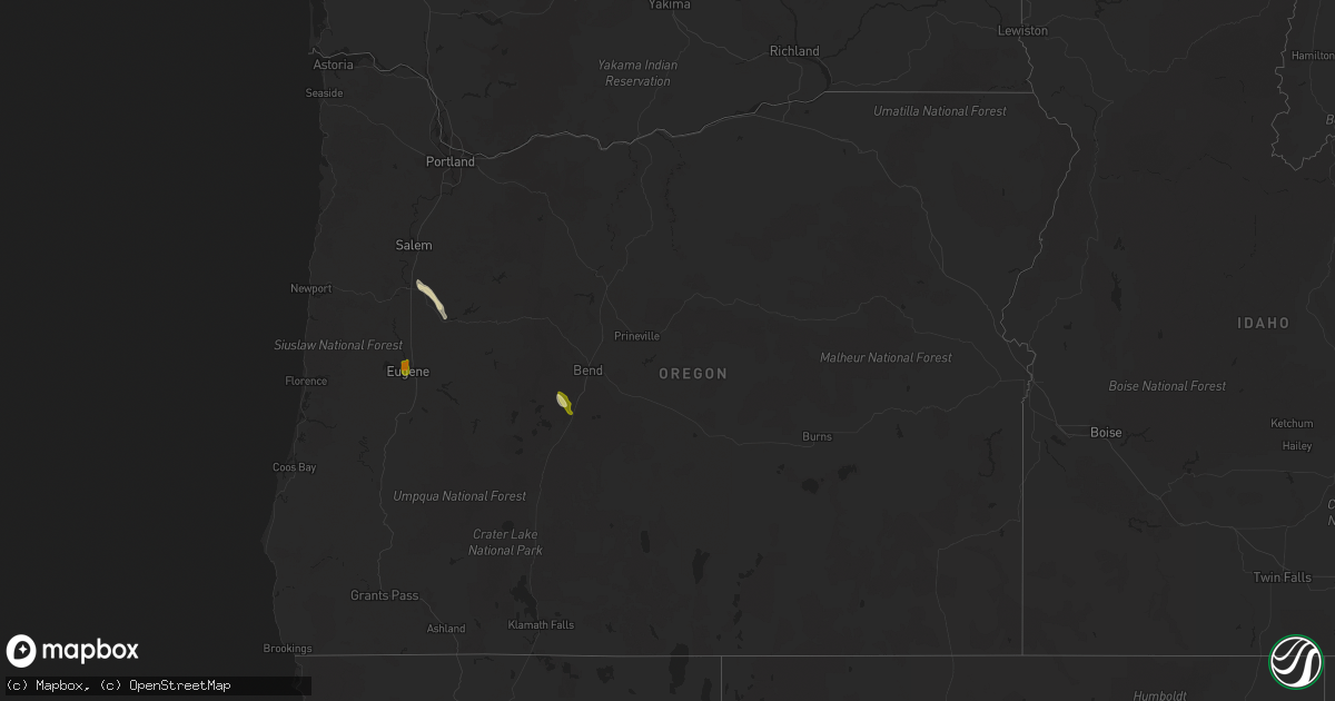
Hail Map in Oregon on August 9, 2022
Get this storm
August 9 map
$229
one time, instant access
Download today. No call, no setup
Keep the $229
Bought the map and want the full workflow? Apply the entire $229 to a subscription within 7 days. None of it is wasted.
Every map, not just this one
This buys you this map. Subscription and you get every map we run, in the markets you choose from a few cities to whole states to nationwide. Plus real-time alerts the moment a storm fires.
Contact data
Name, contact info, occupancy, even credit band for addresses in the footprint. You go from where it hit to who to call.
Become the source they trust
Unlimited branding weather history reports on demand. You already have the documented answer ready for the property owner, and you are the one who showed up with it.
Property data and RoofTrace estimates
Pull up any address you have got, its value and the exact code rules for that jurisdiction, straight from One Click Code. Then RoofTrace estimates the squares, pitch, and roof value, priced the way you price.
Storm reports in Oregon
Oregon
| Date | Description |
|---|---|
| 08/09/20226:45 PM CDT | Tree fell on home. Time estimated from radar. |
| 08/09/20226:30 PM CDT | Downed trees. Power outages. Time estimated from radar. |
| 08/09/20224:55 PM CDT | Sheriff relayed reports from public regarding a couple of hay barns collapsing from the winds. Time estimated from radar. |
| 08/09/20223:25 AM CDT | At 824 PM PDT, a severe thunderstorm was located near Scio, or 9 miles east of Albany, moving northwest at 35 mph. HAZARD...Quarter size hail. SOURCE...Radar indicated. IMPACT...Damage to vehicles is expected. Locations impacted include... Salem, Albany, Monmouth, Independence, Jefferson, Turner, Scio, Four Corners, Marion, Aumsville, Millersburg, Crabtree and Buena Vista. |
| 08/09/20222:56 AM CDT | At 756 PM PDT, a severe thunderstorm was located near Sweet Home, moving north-northwest at 35 mph. HAZARD...Quarter size hail. SOURCE...Radar indicated. IMPACT...Damage to vehicles is expected. Locations impacted include... Sweet Home, Lebanon, Lacomb, South Lebanon, Sodaville, Waterloo, Holley, Crabtree and Foster Reservoir. |
| 08/09/20222:53 AM CDT | At 752 PM PDT, a severe thunderstorm was located 11 miles northeast of Paisley, or 43 miles north of Lakeview, moving north at 45 mph. HAZARD...60 mph wind gusts and quarter size hail. SOURCE...Radar indicated. IMPACT...Hail damage to vehicles is expected. Expect wind damage to roofs, siding, and trees. This severe thunderstorm will remain over mainly rural areas of central Lake County. |
| 08/09/202212:07 AM CDT | At 505 PM PDT, a severe thunderstorm was located 16 miles south of McKenzie Pass, or 22 miles west of Bend, moving northwest at 40 mph. HAZARD...60 mph wind gusts and quarter size hail. SOURCE...Radar indicated. IMPACT...Hail damage to vehicles is expected. Expect wind damage to roofs, siding, and trees. Locations impacted include... McKenzie Pass, Belknap Springs and the Three Sisters. |
| 08/08/202211:45 PM CDT | In direct comparison to a quarter via social media photo...was clearly wider than the quarter. |
| 08/08/202211:43 PM CDT | At 442 PM PDT, a severe thunderstorm was located near Three Rivers, or 14 miles north of La Pine, moving northwest at 40 mph. HAZARD...60 mph wind gusts and half dollar size hail. SOURCE...Radar indicated. IMPACT...Hail damage to vehicles is expected. Expect wind damage to roofs, siding, and trees. Locations impacted include... Three Rivers and Sunriver. |
| 08/08/202211:40 PM CDT | Spotter found a hailstone that was 1 inch in length. |
| 08/08/202211:30 PM CDT | Average of 2.7 centimeter in diameter. |
All States Impacted by Hail Map on August 9, 2022
Cities Impacted by Hail Map on August 9, 2022
- Chickasha, OK
- Middleton, TN
- Saulsbury, TN
- Jackson, TN
- Denmark, TN
- Kaw City, OK
- Union City, TN
- Piedmont, OK
- Fargo, OK
- Buffalo, OK
- Fort Supply, OK
- Collierville, TN
- Lawton, OK
- Tryon, OK
- Chandler, OK
- Cushing, OK
- Stroud, OK
- Agra, OK
- Paden, OK
- Carney, OK
- Depew, OK
- Bolivar, TN
- Dawsonville, GA
- Batesville, MS
- Marlow, OK
- Rush Springs, OK
- Okarche, OK
- Many, LA
- Robeline, LA
- Marthaville, LA
- Fyffe, AL
- Groveoak, AL
- Guthrie, OK
- Greenville, FL
- Laverne, OK
- Ponca City, OK
- El Paso, TX
- Hamlin, TX
- Riceville, TN
- Albany, OR
- Lebanon, OR
- Scio, OR
- Thomas, OK
- Edmond, OK
- Stillwater, OK
- Perry, OK
- Lexington, TN
- Dallas, TX
- Sweet Home, OR
- Crabtree, OR
- Foster, OR
- Jefferson, OR
- Hamburg, AR
- Bend, OR
- Sautee Nacoochee, GA
- Tucson, AZ
- Mooreland, OK
- Tazewell, TN
- Cleo Springs, OK
- Clinton, AR
- Portland, AR
- Lake Village, AR
- Rockholds, KY
- Spring City, TN
- Brooksville, FL
- Kirkland, AZ
- Congress, AZ
- Lockney, TX
- Custer City, OK
- Lookeba, OK
- Hinton, OK
- Baxley, GA
- Hornsby, TN
- La Pine, OR
- Ringwood, OK
- Arab, AL
- Decatur, TN
- Apache, OK
- Sardis, MS
- Tiplersville, MS
- Ashland, MS
- Falkner, MS
- Albertville, AL
- Horton, AL
- Guntersville, AL
- Evensville, TN
- Helena, OK
- Arnett, OK
- Perkins, OK
- Ninnekah, OK
- Pineville, KY
- Cement, OK
- Lubbock, TX
- Centerville, TN
- Memphis, TN
- Copeland, KS
- Meno, OK
- Leesville, LA
- Weaverville, NC
- Barnardsville, NC
- Bon Aqua, TN
- Lyles, TN
- Statesville, NC
- Humboldt, TN
- Brownsville, TN
- Cashion, OK
- Greenwood, MS
- Coila, MS
- Sidon, MS
- Blountsville, AL
- Jacksboro, TX
- Tuttle, OK
- Summer Lake, OR
- Clayton, GA
- Germantown, TN
- Arlington, TN
- Booneville, MS
- Goltry, OK
- Moulton, AL
- La Mesa, NM
- Tallahassee, FL
- Stockton, GA
- Pampa, TX
- Mclean, TX
- Roanoke, VA
- Cullman, AL
- Holly Pond, AL
- Elgin, OK
- Fort Sill, OK
- Fort Bidwell, CA
- Lake City, CA
- Crossville, AL
- Sunflower, MS
- Tolar, TX
- Granbury, TX
- Ramer, TN
- Section, AL
- Clarkesville, GA
- Shattuck, OK
- Woodward, OK
- McCool, MS
- Louisville, MS
- Williamsburg, KY
- Milford, UT
- Ten Mile, TN
- Athens, TN
- Calhoun, TN
- Dickson, TN
- Nettleton, MS
- Indianola, MS
- Lillington, NC
- Angier, NC
- Hornbeck, LA
- Medina, TN
- Oakfield, TN
- Allenhurst, GA
- Ludowici, GA
- Cleveland, GA
- Purlear, NC
- Aubrey, TX
- Stephenville, TX
- Rio Rico, AZ
- Lewisburg, KY
- Russellville, KY
- Elkton, KY
- Amber, OK
- Yukon, OK
- Lancaster, TX
- Ralls, TX
- Ainsworth, NE
- Cherry Log, GA
- El Reno, OK
- Anthony, NM
- Anthony, TX
- Sayre, OK
- Likely, CA
- Perry, FL
- Primm Springs, TN
- Franklin, TN
- Calico Rock, AR
- Doddsville, MS
- Geary, OK
- Fay, OK
- Mountain Rest, SC
- Fackler, AL
- Hollywood, AL
- Hermitage, AR
- Post, TX
- Medon, TN
- Toone, TN
- Coffeeville, MS
- Oakland, MS
- Dawson, AL
- Cumming, GA
- Silver Lake, OR
- Eugene, OR


