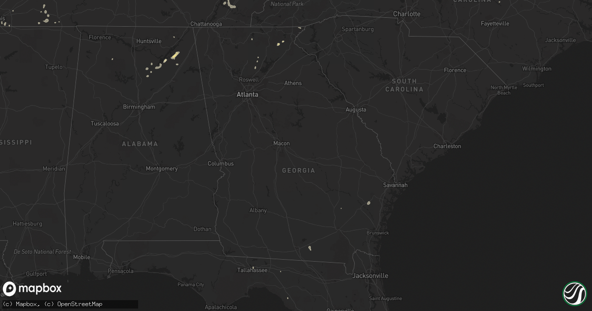
Hail Map in Georgia on August 9, 2022
Get this storm
August 9 map
$229
one time, instant access
Download today. No call, no setup
Keep the $229
Bought the map and want the full workflow? Apply the entire $229 to a subscription within 7 days. None of it is wasted.
Every map, not just this one
This buys you this map. Subscription and you get every map we run, in the markets you choose from a few cities to whole states to nationwide. Plus real-time alerts the moment a storm fires.
Contact data
Name, contact info, occupancy, even credit band for addresses in the footprint. You go from where it hit to who to call.
Become the source they trust
Unlimited branding weather history reports on demand. You already have the documented answer ready for the property owner, and you are the one who showed up with it.
Property data and RoofTrace estimates
Pull up any address you have got, its value and the exact code rules for that jurisdiction, straight from One Click Code. Then RoofTrace estimates the squares, pitch, and roof value, priced the way you price.
Storm reports in Georgia
Georgia
| Date | Description |
|---|---|
| 08/09/20226:40 PM CDT | Report of trees down across highway 135 caused by thunderstorm. |
| 08/09/20226:15 PM CDT | Delayed report. A swath of thunderstorm wind damage was reported along axon road in atkinson county ga. Powerlines and trees were downed along with several damaged shed |
| 08/09/20225:55 PM CDT | Trees down along us 221 with a couple of transformers blown in the surrounding area. Time estimated by radar. |
| 08/09/20224:53 PM CDT | Tree down on murphy st. |
| 08/09/20224:50 PM CDT | Power line down on tucker rd. |
| 08/09/20224:50 PM CDT | Tree down on poplar st. |
| 08/09/20224:49 PM CDT | Tree down on sherwood road. |
| 08/09/20224:49 PM CDT | Tree down near intersection of bay ln and fred ln. |
| 08/09/20224:44 PM CDT | Tree down on 4-h club rd. |
| 08/09/20222:55 PM CDT | 911 call center reported tree blocking roadway on brandon mill road. |
| 08/09/20222:55 PM CDT | 911 call center reported trees fell on powerlines and blocking roadway on lake rabun road. |
| 08/09/20222:30 PM CDT | 911 call center reported trees fell on powerlines and blocking roadway on earls ford road. |
| 08/09/20222:15 PM CDT | Trees reported down on top of mt yonah. |
| 08/09/20222:25 AM CDT | At 725 PM EDT, severe thunderstorms were located along a line extending from near Ambrose to 7 miles west of Dixie Union, moving northeast at 35 mph. HAZARD...70 mph wind gusts. SOURCE...Radar indicated. IMPACT...Expect considerable tree damage. Damage is likely to mobile homes, roofs, and outbuildings. Locations impacted include... Douglas, Baxley, Hazlehurst, Alma, Broxton, Ambrose, Graham, Surrency, Plant Hatch and Nicholls. |
| 08/09/20222:02 AM CDT | At 702 PM EDT, severe thunderstorms were located along a line extending from 9 miles northeast of Alapaha to near Cogdell, moving northeast at 40 mph. HAZARD...60 mph wind gusts. SOURCE...Radar indicated. IMPACT...Expect damage to roofs, siding, and trees. Locations impacted include... Douglas, Alma, Pearson, Broxton, Ambrose, Nicholls, Pridgen, Snipesville, West Green and Denton. |
| 08/09/202212:56 AM CDT | At 556 PM EDT, a severe thunderstorm was located near Statenville, moving north at 20 mph. HAZARD...60 mph wind gusts. SOURCE...Radar indicated. IMPACT...Expect damage to roofs, siding, and trees. Locations impacted include... Statenville, Du Pont and Mayday. |
| 08/08/202211:46 PM CDT | At 446 PM EDT, a severe thunderstorm was located 11 miles southwest of Madison, moving north at 15 mph. HAZARD...60 mph wind gusts. SOURCE...Radar indicated. IMPACT...Expect damage to roofs, siding, and trees. Locations impacted include... Madison, Lee, Moseley Hall, Hopewell, Cherry Lake, Hamburg, Hanson and Pinetta. |
| 08/08/202211:04 PM CDT | At 403 PM EDT, a severe thunderstorm was located 7 miles northwest of Walhalla, or 4 miles southwest of Oconee State Park, moving east at 20 mph. HAZARD...60 mph wind gusts and penny size hail. SOURCE...Radar indicated. IMPACT...Expect damage to trees and power lines. Locations impacted include... Walhalla, Salem, Devils Fork State Park, Lake Keowee, Oconee State Park, Mountain Rest, Long Creek and Lake Jocassee. |
| 08/08/202210:10 PM CDT | At 310 PM EDT, a severe thunderstorm was located over Sautee, or near Cleveland, moving northeast at 15 mph. HAZARD...60 mph wind gusts and quarter size hail. SOURCE...Radar indicated. IMPACT...Hail damage to vehicles is expected. Expect wind damage to roofs, siding, and trees. Locations impacted include... Cleveland, Helen, Unicoi State Park, Robertstown, Anna Ruby Falls, Leaf, Smithgall Woods Conservation Are, Sautee and Qualatchee Lake. |
| 08/08/20229:25 PM CDT | At 225 PM EDT, a severe thunderstorm was located over Silver City, or near Dawsonville, moving northeast at 20 mph. HAZARD...60 mph wind gusts and quarter size hail. SOURCE...Radar indicated. IMPACT...Hail damage to vehicles is expected. Expect wind damage to roofs, siding, and trees. Locations impacted include... Cumming, Dawsonville, Dougherty, Matt, Silver City, Chestatee, Hollis Lathem Reservoir, Ducktown, Coal Mountain, Hightower, War Hill Park and McKee. |
| 08/08/20227:37 PM CDT | Trees and powerlines were reported down along old dairy road. |
All States Impacted by Hail Map on August 9, 2022
Cities Impacted by Hail Map on August 9, 2022
- Chickasha, OK
- Middleton, TN
- Saulsbury, TN
- Jackson, TN
- Denmark, TN
- Kaw City, OK
- Union City, TN
- Piedmont, OK
- Fargo, OK
- Buffalo, OK
- Fort Supply, OK
- Collierville, TN
- Lawton, OK
- Tryon, OK
- Chandler, OK
- Cushing, OK
- Stroud, OK
- Agra, OK
- Paden, OK
- Carney, OK
- Depew, OK
- Bolivar, TN
- Dawsonville, GA
- Batesville, MS
- Marlow, OK
- Rush Springs, OK
- Okarche, OK
- Many, LA
- Robeline, LA
- Marthaville, LA
- Fyffe, AL
- Groveoak, AL
- Guthrie, OK
- Greenville, FL
- Laverne, OK
- Ponca City, OK
- El Paso, TX
- Hamlin, TX
- Riceville, TN
- Albany, OR
- Lebanon, OR
- Scio, OR
- Thomas, OK
- Edmond, OK
- Stillwater, OK
- Perry, OK
- Lexington, TN
- Dallas, TX
- Sweet Home, OR
- Crabtree, OR
- Foster, OR
- Jefferson, OR
- Hamburg, AR
- Bend, OR
- Sautee Nacoochee, GA
- Tucson, AZ
- Mooreland, OK
- Tazewell, TN
- Cleo Springs, OK
- Clinton, AR
- Portland, AR
- Lake Village, AR
- Rockholds, KY
- Spring City, TN
- Brooksville, FL
- Kirkland, AZ
- Congress, AZ
- Lockney, TX
- Custer City, OK
- Lookeba, OK
- Hinton, OK
- Baxley, GA
- Hornsby, TN
- La Pine, OR
- Ringwood, OK
- Arab, AL
- Decatur, TN
- Apache, OK
- Sardis, MS
- Tiplersville, MS
- Ashland, MS
- Falkner, MS
- Albertville, AL
- Horton, AL
- Guntersville, AL
- Evensville, TN
- Helena, OK
- Arnett, OK
- Perkins, OK
- Ninnekah, OK
- Pineville, KY
- Cement, OK
- Lubbock, TX
- Centerville, TN
- Memphis, TN
- Copeland, KS
- Meno, OK
- Leesville, LA
- Weaverville, NC
- Barnardsville, NC
- Bon Aqua, TN
- Lyles, TN
- Statesville, NC
- Humboldt, TN
- Brownsville, TN
- Cashion, OK
- Greenwood, MS
- Coila, MS
- Sidon, MS
- Blountsville, AL
- Jacksboro, TX
- Tuttle, OK
- Summer Lake, OR
- Clayton, GA
- Germantown, TN
- Arlington, TN
- Booneville, MS
- Goltry, OK
- Moulton, AL
- La Mesa, NM
- Tallahassee, FL
- Stockton, GA
- Pampa, TX
- Mclean, TX
- Roanoke, VA
- Cullman, AL
- Holly Pond, AL
- Elgin, OK
- Fort Sill, OK
- Fort Bidwell, CA
- Lake City, CA
- Crossville, AL
- Sunflower, MS
- Tolar, TX
- Granbury, TX
- Ramer, TN
- Section, AL
- Clarkesville, GA
- Shattuck, OK
- Woodward, OK
- McCool, MS
- Louisville, MS
- Williamsburg, KY
- Milford, UT
- Ten Mile, TN
- Athens, TN
- Calhoun, TN
- Dickson, TN
- Nettleton, MS
- Indianola, MS
- Lillington, NC
- Angier, NC
- Hornbeck, LA
- Medina, TN
- Oakfield, TN
- Allenhurst, GA
- Ludowici, GA
- Cleveland, GA
- Purlear, NC
- Aubrey, TX
- Stephenville, TX
- Rio Rico, AZ
- Lewisburg, KY
- Russellville, KY
- Elkton, KY
- Amber, OK
- Yukon, OK
- Lancaster, TX
- Ralls, TX
- Ainsworth, NE
- Cherry Log, GA
- El Reno, OK
- Anthony, NM
- Anthony, TX
- Sayre, OK
- Likely, CA
- Perry, FL
- Primm Springs, TN
- Franklin, TN
- Calico Rock, AR
- Doddsville, MS
- Geary, OK
- Fay, OK
- Mountain Rest, SC
- Fackler, AL
- Hollywood, AL
- Hermitage, AR
- Post, TX
- Medon, TN
- Toone, TN
- Coffeeville, MS
- Oakland, MS
- Dawson, AL
- Cumming, GA
- Silver Lake, OR
- Eugene, OR


