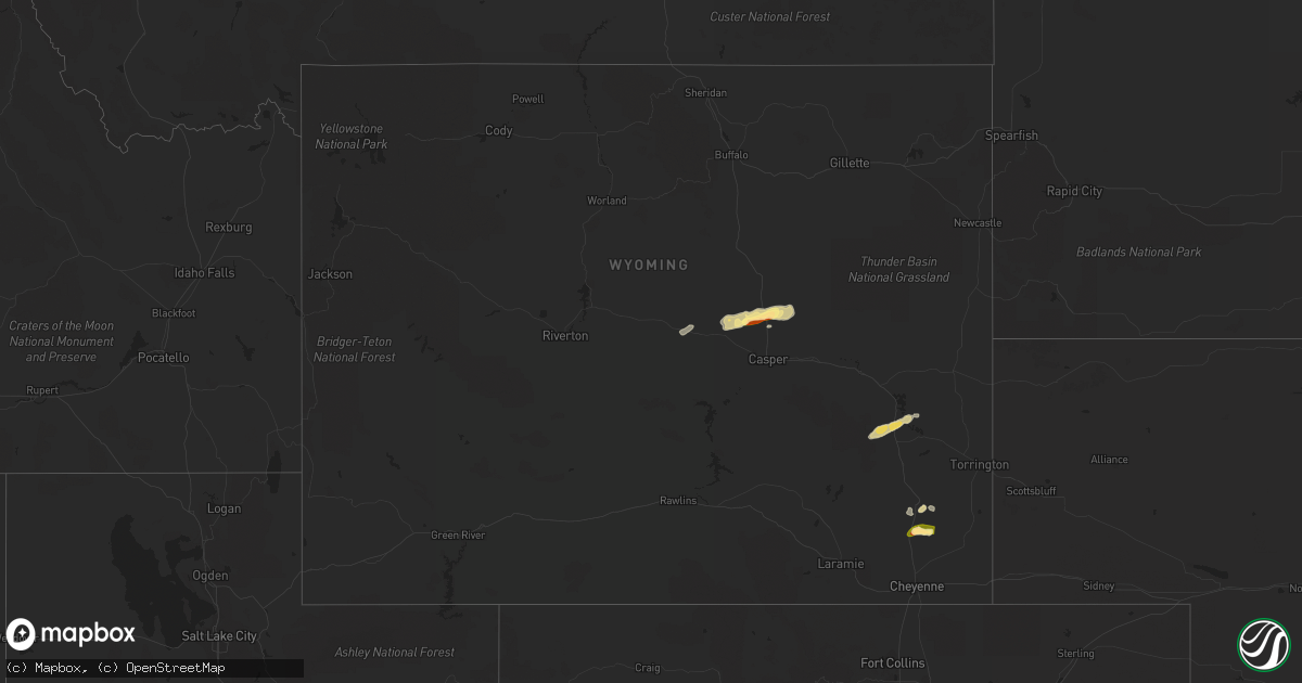
Hail Map in Wyoming on August 6, 2022
Get this storm
August 6 map
$229
one time, instant access
Download today. No call, no setup
Keep the $229
Bought the map and want the full workflow? Apply the entire $229 to a subscription within 7 days. None of it is wasted.
Every map, not just this one
This buys you this map. Subscription and you get every map we run, in the markets you choose from a few cities to whole states to nationwide. Plus real-time alerts the moment a storm fires.
Contact data
Name, contact info, occupancy, even credit band for addresses in the footprint. You go from where it hit to who to call.
Become the source they trust
Unlimited branding weather history reports on demand. You already have the documented answer ready for the property owner, and you are the one who showed up with it.
Property data and RoofTrace estimates
Pull up any address you have got, its value and the exact code rules for that jurisdiction, straight from One Click Code. Then RoofTrace estimates the squares, pitch, and roof value, priced the way you price.
Storm reports in Wyoming
Wyoming
| Date | Description |
|---|---|
| 08/06/20226:40 PM CDT | Severe t-storm wind gust to 66 mph on wy dot mesonet i-80 at french. |
| 08/06/20226:22 PM CDT | Severe t-storm wind gust to 68 mph on wy dot mesonet site at i-80/first divide. |
| 08/06/202212:41 AM CDT | At 539 PM MDT, a severe thunderstorm was located near Mountain View, or 27 miles east of Evanston, moving northeast at 40 mph. HAZARD...60 mph wind gusts and quarter size hail. SOURCE...Radar indicated with winds confirmed by a mesonet observation. IMPACT...Hail damage to vehicles is expected. Expect wind damage to roofs, siding, and trees. Locations impacted include... Lyman, Robertson, Mountain View, Millburne, Church Buttes, Fort Bridger and Carter.This includes Interstate 80 in Wyoming between mile markers 26 and56. |
| 08/06/202212:14 AM CDT | At 513 PM MDT, a severe thunderstorm was located 14 miles northeast of Whitaker, or 28 miles north of Cheyenne, moving east at 10 mph. HAZARD...60 mph wind gusts and quarter size hail. SOURCE...Radar indicated. IMPACT...Hail damage to vehicles is expected. Expect wind damage to roofs, siding, and trees. This severe thunderstorm will remain over mainly rural areas of southwestern Goshen, north central Laramie and southeastern Platte Counties. |
| 08/05/202211:33 PM CDT | At 432 PM MDT, a severe thunderstorm was located 10 miles north of Whitaker, or 28 miles north of Cheyenne, moving northeast at 10 mph. HAZARD...60 mph wind gusts and quarter size hail. SOURCE...Radar indicated. IMPACT...Hail damage to vehicles is expected. Expect wind damage to roofs, siding, and trees. This severe thunderstorm will remain over mainly rural areas of southwestern Goshen, north central Laramie and southeastern Platte Counties.This includes Interstate 25 in Wyoming between mile markers 37 and50. |
| 08/05/202210:50 PM CDT | At 349 PM MDT, a severe thunderstorm was located 12 miles east of Teapot Rock, or 26 miles northeast of Casper, moving east at 40 mph. HAZARD...60 mph wind gusts and half dollar size hail. SOURCE...Radar indicated. IMPACT...Hail damage to vehicles is expected. Expect wind damage to roofs, siding, and trees. This severe thunderstorm will remain over mainly rural areas of northwestern Converse County. |
| 08/05/202210:38 PM CDT | At 337 PM MDT, a severe thunderstorm was located near Teapot Rock, or 25 miles north of Casper, moving east at 40 mph. HAZARD...Ping pong ball size hail and 60 mph wind gusts. SOURCE...Radar indicated. IMPACT...People and animals outdoors will be injured. Expect hail damage to roofs, siding, windows, and vehicles. Expect wind damage to roofs, siding, and trees. This severe thunderstorm will remain over mainly rural areas of east central Natrona County. |
| 08/05/202210:02 PM CDT | At 302 PM MDT, a severe thunderstorm was located 9 miles northeast of Goldeneye Reservoir, or 24 miles northwest of Casper, moving east at 30 mph. HAZARD...60 mph wind gusts and quarter size hail. SOURCE...Radar indicated. IMPACT...Hail damage to vehicles is expected. Expect wind damage to roofs, siding, and trees. Locations impacted include... Antelope Hills and Teapot Rock.This includes Interstate 25 between mile markers 200 and 217. |
| 08/05/20229:19 PM CDT | At 218 PM MDT, a severe thunderstorm was located near Powder River, or 38 miles northwest of Casper, moving east at 40 mph. HAZARD...60 mph wind gusts and quarter size hail. SOURCE...Radar indicated. IMPACT...Hail damage to vehicles is expected. Expect wind damage to roofs, siding, and trees. This severe thunderstorm will remain over mainly rural areas of central Natrona County, including the following locations... Natrona. |
All States Impacted by Hail Map on August 6, 2022
Cities Impacted by Hail Map on August 6, 2022
- West Point, KY
- Bardstown, KY
- Bloomfield, KY
- Taylorsville, KY
- Hanlontown, IA
- Fertile, IA
- Mason City, IA
- Clear Lake, IA
- Garner, IA
- Ventura, IA
- Forest City, IA
- Estherville, IA
- Arapahoe, CO
- Sheridan Lake, CO
- Rockwell, IA
- Lanesville, IN
- Georgetown, IN
- Chugwater, WY
- Las Animas, CO
- Hasty, CO
- McClave, CO
- Murfreesboro, TN
- Christiana, TN
- Denver, CO
- Denver, NC
- Simla, CO
- Calhan, CO
- Ramah, CO
- Limon, CO
- Matheson, CO
- Bowling Green, KY
- Campbellsville, KY
- Hampshire, TN
- Mount Pleasant, TN
- Decatur, GA
- Stone Mountain, GA
- Lithonia, GA
- Wisconsin Rapids, WI
- Olney Springs, CO
- Ordway, CO
- Coxs Creek, KY
- Corydon, IN
- Hodgenville, KY
- Nashville, TN
- Fort Gaines, GA
- Aurora, CO
- Radcliff, KY
- Fort Knox, KY
- Brooks, GA
- Horse Cave, KY
- Horton, AL
- Boaz, AL
- Altoona, AL
- Atlanta, GA
- Rush, CO
- New Haven, KY
- Woolstock, IA
- Blairsburg, IA
- Lu Verne, IA
- Livermore, IA
- Allison, IA
- Greene, IA
- Pine, CO
- Bailey, CO
- Elizabethtown, KY
- Hudson, KY
- Agate, CO
- Crossville, TN
- Athens, AL
- Harvest, AL
- Oneonta, AL
- Greenwood, FL
- Grand Ridge, FL
- Sneads, FL
- Andalusia, AL
- Glendo, WY
- Hartville, WY
- Wheatland, WY
- Kanawha, IA
- Clarion, IA
- Sheffield, IA
- Big Clifty, KY
- Belton, SC
- Freeport, FL
- Casper, WY
- Covington, GA
- Conyers, GA
- Cuthbert, GA
- Rutledge, AL
- Honoraville, AL
- Luverne, AL
- Elfrida, AZ
- Dunnville, KY
- Columbia, KY
- Jemison, AL
- Hawk Springs, WY
- Raywick, KY
- Wallingford, IA
- Buffalo, KY
- Wilder, TN
- Crawford, TN
- Clarkrange, TN
- Monterey, TN
- Round Lake, MN
- New Salisbury, IN
- Joice, IA
- Kensett, IA
- Rocky Ford, CO
- La Junta, CO
- Swink, CO
- Algona, IA
- Britt, IA
- Rockford, IA
- Marble Rock, IA
- Galt, IA
- Eagle Grove, IA
- Brewster, MN
- Worthington, MN
- Benton, WI
- Cuba City, WI
- Lascassas, TN
- Loretto, TN
- Lexington, AL
- Roundhill, KY
- Caryville, TN
- Ottosen, IA
- Bradgate, IA
- Bode, IA
- Humboldt, IA
- Rutland, IA
- Lime Springs, IA
- Elma, IA
- Magnolia, KY
- Cochise, AZ
- New Hope, KY
- Loretto, KY
- Berry, AL
- Hugo, CO
- Dublin, GA
- Kit Carson, CO
- Bethune, CO
- Burlington, CO
- Stratton, CO
- Vincent, IA
- Thor, IA
- Badger, IA
- Fitzgerald, GA
- Calera, AL
- Renwick, IA
- Hardy, IA
- Goldfield, IA
- Orrville, AL
- Glens Fork, KY
- Trenton, GA
- Lebanon, TN
- Troy, AL
- Summersville, KY
- Clanton, AL
- Collinsville, AL
- Lake Mills, IA
- Ider, AL
- Smiths Grove, KY
- Macon, GA
- Alpine, TN
- Ayrshire, IA
- Curlew, IA
- Emmetsburg, IA
- Haswell, CO
- Karval, CO
- Box Springs, GA
- Thornton, IA
- Bisbee, AZ
- Douglas, AZ
- Oakland, KY
- Castalian Springs, TN
- Shorterville, AL
- Leitchfield, KY
- Allred, TN
- Blakely, GA
- Camp Hill, AL
- Waverly, AL
- Goodwater, AL
- Mammoth Cave, KY
- Brownsville, KY
- Park City, KY
- Cave City, KY
- Lenoir City, TN
- Wildwood, GA
- McNeal, AZ
- Cottondale, AL
- Commerce City, CO
- Brighton, CO
- Henderson, CO
- Danville, AL
- Minter, AL
- Elgin, AZ
- Madison, AL
- Huntsville, AL
- Bethpage, TN
- Gallatin, TN
- Cottonwood, AL
- Riverdale, GA
- Fayetteville, GA
- Sumner, IA
- Fredericksburg, IA
- Bainbridge, GA
- Lebanon, KY
- Cheyenne Wells, CO
- Chattanooga, TN
- Edmonton, KY
- Knifley, KY
- Elk Horn, KY
- Hermitage, TN
- Dothan, AL
- Ashford, AL
- Greenville, AL
- Greensburg, KY
- Buena Vista, GA
- Mauk, GA
- Lewisport, KY
- Maceo, KY
- Tucker, GA
- Loudon, TN
- Rogersville, AL
- Killen, AL
- Yoder, CO
- Quitman, GA
- Ruthven, IA
- Whigham, GA
- Cheyenne, WY
- Jetson, KY
- Morgantown, KY
- Tuscaloosa, AL
- Blountstown, FL
- Banks, AL
- Junction City, GA
- Eastpoint, FL
- Avondale Estates, GA
- Auburn, KY
- Rebecca, GA
- Hixson, TN
- Ashburn, GA
- Sycamore, GA
- Fyffe, AL
- Fort Payne, AL
- Dawson, AL
- Moulton, AL
- Spring Hill, TN
- Columbia, TN
- Canmer, KY
- Kanorado, KS
- Abbeville, GA
- Marianna, FL
- Malone, FL
- Castleberry, AL
- Franklin, KY
- Portland, TN
- Cross Plains, TN
- Brewton, AL
- Norman Park, GA
- Moultrie, GA
- Flat Rock, AL
- Rising Fawn, GA
- Calvin, KY
- Pineville, KY
- Meservey, IA
- Klemme, IA
- Rockland, WI
- Bangor, WI
- Sparta, WI
- Cashton, WI
- Westby, WI
- Ontario, WI
- Norwalk, WI
- Trinidad, CO


