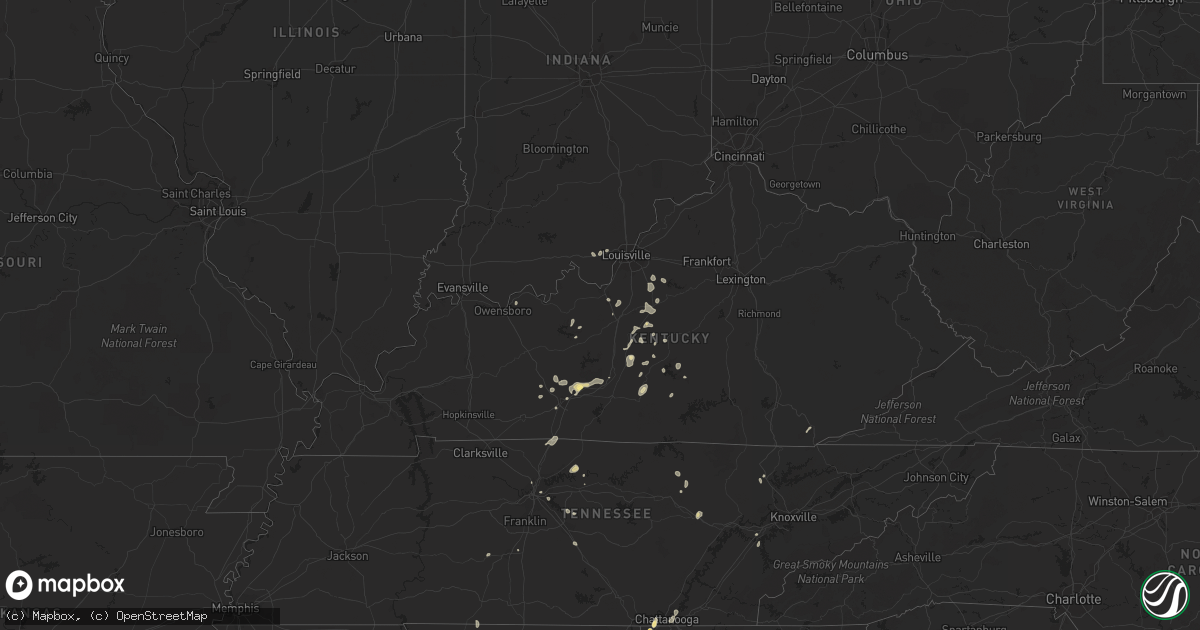
Hail Map in Kentucky on August 6, 2022
Get this storm
August 6 map
$229
one time, instant access
Download today. No call, no setup
Keep the $229
Bought the map and want the full workflow? Apply the entire $229 to a subscription within 7 days. None of it is wasted.
Every map, not just this one
This buys you this map. Subscription and you get every map we run, in the markets you choose from a few cities to whole states to nationwide. Plus real-time alerts the moment a storm fires.
Contact data
Name, contact info, occupancy, even credit band for addresses in the footprint. You go from where it hit to who to call.
Become the source they trust
Unlimited branding weather history reports on demand. You already have the documented answer ready for the property owner, and you are the one who showed up with it.
Property data and RoofTrace estimates
Pull up any address you have got, its value and the exact code rules for that jurisdiction, straight from One Click Code. Then RoofTrace estimates the squares, pitch, and roof value, priced the way you price.
Storm reports in Kentucky
Kentucky
| Date | Description |
|---|---|
| 08/06/20223:01 PM CDT | Couple of trees down. |
| 08/06/20222:23 PM CDT | Reported via mping. |
| 08/05/202211:14 PM CDT | At 414 PM EDT, severe thunderstorms were located along a line extending from near Taylorsville to 6 miles north of Bardstown, moving south at 15 mph. HAZARD...60 mph wind gusts. SOURCE...Radar indicated. IMPACT...Expect damage to roofs, siding, and trees. Locations impacted include... Taylorsville, Bloomfield, Wakefield, Chaplin and Coxs Creek. |
| 08/05/202210:58 PM CDT | At 357 PM EDT, severe thunderstorms were from 8 miles southwest of Taylorsville to 9 miles south of Shepherdsville, moving east at 10 mph. HAZARD...60 mph wind gusts. SOURCE...Radar indicated. IMPACT...Expect damage to roofs, siding, and trees. These severe thunderstorms will affect the following locations... Samuels, Ridgetop, Highgrove, Solitude, Hobbs, Scuffletown, Deatsville, Brownington, Lotus, and Lenore. |
| 08/05/202210:52 PM CDT | At 352 PM EDT, a severe thunderstorm was located near Taylorsville, moving northeast at 15 mph. HAZARD...60 mph wind gusts. SOURCE...Radar indicated. IMPACT...Expect damage to roofs, siding, and trees. Locations impacted include... Taylorsville, Yoder, Normandy, Elk Creek and Waterford. |
| 08/05/20229:39 PM CDT | At 238 PM CDT, severe thunderstorms were from 7 miles southeast of Brownsville to 9 miles north of Glasgow, moving east at 45 mph. HAZARD...60 mph wind gusts and quarter size hail. SOURCE...Radar indicated. IMPACT...Hail damage to vehicles is expected. Expect wind damage to roofs, siding, and trees. Locations impacted include... Brownsville, Horse Cave, Chalybeate, Rowletts, Logsdon Valley, Straw, Mammoth Cave, Northtown, Legrande, and Uno. |
| 08/05/20229:09 PM CDT | At 209 PM CDT, severe thunderstorms were from 8 miles west of Brownsville to 9 miles east of Plum Springs, moving east at 20 mph. HAZARD...60 mph wind gusts and quarter size hail. SOURCE...Radar indicated. IMPACT...Hail damage to vehicles is expected. Expect wind damage to roofs, siding, and trees. Locations impacted include... Brownsville. |
All States Impacted by Hail Map on August 6, 2022
Cities Impacted by Hail Map on August 6, 2022
- West Point, KY
- Bardstown, KY
- Bloomfield, KY
- Taylorsville, KY
- Hanlontown, IA
- Fertile, IA
- Mason City, IA
- Clear Lake, IA
- Garner, IA
- Ventura, IA
- Forest City, IA
- Estherville, IA
- Arapahoe, CO
- Sheridan Lake, CO
- Rockwell, IA
- Lanesville, IN
- Georgetown, IN
- Chugwater, WY
- Las Animas, CO
- Hasty, CO
- McClave, CO
- Murfreesboro, TN
- Christiana, TN
- Denver, CO
- Denver, NC
- Simla, CO
- Calhan, CO
- Ramah, CO
- Limon, CO
- Matheson, CO
- Bowling Green, KY
- Campbellsville, KY
- Hampshire, TN
- Mount Pleasant, TN
- Decatur, GA
- Stone Mountain, GA
- Lithonia, GA
- Wisconsin Rapids, WI
- Olney Springs, CO
- Ordway, CO
- Coxs Creek, KY
- Corydon, IN
- Hodgenville, KY
- Nashville, TN
- Fort Gaines, GA
- Aurora, CO
- Radcliff, KY
- Fort Knox, KY
- Brooks, GA
- Horse Cave, KY
- Horton, AL
- Boaz, AL
- Altoona, AL
- Atlanta, GA
- Rush, CO
- New Haven, KY
- Woolstock, IA
- Blairsburg, IA
- Lu Verne, IA
- Livermore, IA
- Allison, IA
- Greene, IA
- Pine, CO
- Bailey, CO
- Elizabethtown, KY
- Hudson, KY
- Agate, CO
- Crossville, TN
- Athens, AL
- Harvest, AL
- Oneonta, AL
- Greenwood, FL
- Grand Ridge, FL
- Sneads, FL
- Andalusia, AL
- Glendo, WY
- Hartville, WY
- Wheatland, WY
- Kanawha, IA
- Clarion, IA
- Sheffield, IA
- Big Clifty, KY
- Belton, SC
- Freeport, FL
- Casper, WY
- Covington, GA
- Conyers, GA
- Cuthbert, GA
- Rutledge, AL
- Honoraville, AL
- Luverne, AL
- Elfrida, AZ
- Dunnville, KY
- Columbia, KY
- Jemison, AL
- Hawk Springs, WY
- Raywick, KY
- Wallingford, IA
- Buffalo, KY
- Wilder, TN
- Crawford, TN
- Clarkrange, TN
- Monterey, TN
- Round Lake, MN
- New Salisbury, IN
- Joice, IA
- Kensett, IA
- Rocky Ford, CO
- La Junta, CO
- Swink, CO
- Algona, IA
- Britt, IA
- Rockford, IA
- Marble Rock, IA
- Galt, IA
- Eagle Grove, IA
- Brewster, MN
- Worthington, MN
- Benton, WI
- Cuba City, WI
- Lascassas, TN
- Loretto, TN
- Lexington, AL
- Roundhill, KY
- Caryville, TN
- Ottosen, IA
- Bradgate, IA
- Bode, IA
- Humboldt, IA
- Rutland, IA
- Lime Springs, IA
- Elma, IA
- Magnolia, KY
- Cochise, AZ
- New Hope, KY
- Loretto, KY
- Berry, AL
- Hugo, CO
- Dublin, GA
- Kit Carson, CO
- Bethune, CO
- Burlington, CO
- Stratton, CO
- Vincent, IA
- Thor, IA
- Badger, IA
- Fitzgerald, GA
- Calera, AL
- Renwick, IA
- Hardy, IA
- Goldfield, IA
- Orrville, AL
- Glens Fork, KY
- Trenton, GA
- Lebanon, TN
- Troy, AL
- Summersville, KY
- Clanton, AL
- Collinsville, AL
- Lake Mills, IA
- Ider, AL
- Smiths Grove, KY
- Macon, GA
- Alpine, TN
- Ayrshire, IA
- Curlew, IA
- Emmetsburg, IA
- Haswell, CO
- Karval, CO
- Box Springs, GA
- Thornton, IA
- Bisbee, AZ
- Douglas, AZ
- Oakland, KY
- Castalian Springs, TN
- Shorterville, AL
- Leitchfield, KY
- Allred, TN
- Blakely, GA
- Camp Hill, AL
- Waverly, AL
- Goodwater, AL
- Mammoth Cave, KY
- Brownsville, KY
- Park City, KY
- Cave City, KY
- Lenoir City, TN
- Wildwood, GA
- McNeal, AZ
- Cottondale, AL
- Commerce City, CO
- Brighton, CO
- Henderson, CO
- Danville, AL
- Minter, AL
- Elgin, AZ
- Madison, AL
- Huntsville, AL
- Bethpage, TN
- Gallatin, TN
- Cottonwood, AL
- Riverdale, GA
- Fayetteville, GA
- Sumner, IA
- Fredericksburg, IA
- Bainbridge, GA
- Lebanon, KY
- Cheyenne Wells, CO
- Chattanooga, TN
- Edmonton, KY
- Knifley, KY
- Elk Horn, KY
- Hermitage, TN
- Dothan, AL
- Ashford, AL
- Greenville, AL
- Greensburg, KY
- Buena Vista, GA
- Mauk, GA
- Lewisport, KY
- Maceo, KY
- Tucker, GA
- Loudon, TN
- Rogersville, AL
- Killen, AL
- Yoder, CO
- Quitman, GA
- Ruthven, IA
- Whigham, GA
- Cheyenne, WY
- Jetson, KY
- Morgantown, KY
- Tuscaloosa, AL
- Blountstown, FL
- Banks, AL
- Junction City, GA
- Eastpoint, FL
- Avondale Estates, GA
- Auburn, KY
- Rebecca, GA
- Hixson, TN
- Ashburn, GA
- Sycamore, GA
- Fyffe, AL
- Fort Payne, AL
- Dawson, AL
- Moulton, AL
- Spring Hill, TN
- Columbia, TN
- Canmer, KY
- Kanorado, KS
- Abbeville, GA
- Marianna, FL
- Malone, FL
- Castleberry, AL
- Franklin, KY
- Portland, TN
- Cross Plains, TN
- Brewton, AL
- Norman Park, GA
- Moultrie, GA
- Flat Rock, AL
- Rising Fawn, GA
- Calvin, KY
- Pineville, KY
- Meservey, IA
- Klemme, IA
- Rockland, WI
- Bangor, WI
- Sparta, WI
- Cashton, WI
- Westby, WI
- Ontario, WI
- Norwalk, WI
- Trinidad, CO


