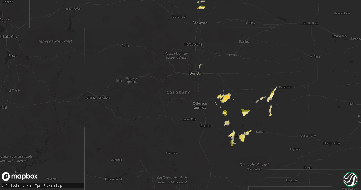
Hail Map in Colorado on August 6, 2022
Get this storm
August 6 map
$229
one time, instant access
Download today. No call, no setup
Keep the $229
Bought the map and want the full workflow? Apply the entire $229 to a subscription within 7 days. None of it is wasted.
Every map, not just this one
This buys you this map. Subscription and you get every map we run, in the markets you choose from a few cities to whole states to nationwide. Plus real-time alerts the moment a storm fires.
Contact data
Name, contact info, occupancy, even credit band for addresses in the footprint. You go from where it hit to who to call.
Become the source they trust
Unlimited branding weather history reports on demand. You already have the documented answer ready for the property owner, and you are the one who showed up with it.
Property data and RoofTrace estimates
Pull up any address you have got, its value and the exact code rules for that jurisdiction, straight from One Click Code. Then RoofTrace estimates the squares, pitch, and roof value, priced the way you price.
Storm reports in Colorado
Colorado
| Date | Description |
|---|---|
| 08/06/20225:06 AM CDT | At 1006 PM MDT, a severe thunderstorm was located 17 miles north of Cheyenne Wells, moving northeast at 10 mph. HAZARD...60 mph wind gusts and quarter size hail. SOURCE...Radar indicated. IMPACT...Hail damage to vehicles is expected. Expect wind damage to roofs, siding, and trees. This severe thunderstorm will remain over mainly rural areas of northeastern Cheyenne and southeastern Kit Carson Counties in east central Colorado, northwestern Wallace County in west central Kansas and southwestern Sherman Counties in northwestern Kansas.This includes the following highways... Interstate 70 in Kansas between mile markers 0 and 4. Interstate 70 in Colorado between mile markers 436 and 450. Highway 385 between mile markers 163 and 190. |
| 08/06/20222:31 AM CDT | At 731 PM MDT, a severe thunderstorm was located 6 miles northwest of Hugo, or 8 miles southeast of Limon, moving east at 15 mph. HAZARD...60 mph wind gusts and penny size hail. SOURCE...Radar indicated. IMPACT...Expect damage to roofs, siding, and trees. Locations impacted include... Hugo and Genoa. |
| 08/06/20222:02 AM CDT | At 701 PM MDT, a severe thunderstorm was located 11 miles south of Limon, moving northeast at 20 mph. HAZARD...70 mph wind gusts and ping pong ball size hail. SOURCE...Radar indicated. IMPACT...Expect considerable tree damage. Damage is likely to mobile homes, roofs, and outbuildings. People and animals outdoors will be injured. Expect hail damage to roofs, siding, windows, and vehicles. Hail may accumulate on roadways causing hazardous travel. Locations impacted include... Limon and Hugo. |
| 08/06/20221:37 AM CDT | At 637 PM MDT, a severe thunderstorm was located 9 miles southeast of Matheson, or 17 miles southwest of Limon, moving northeast at 20 mph. HAZARD...Ping pong ball size hail and 60 mph wind gusts. SOURCE...Radar indicated. IMPACT...Expect damage to roofs, siding, and trees. People and animals outdoors will be injured. Expect hail damage to roofs, siding, windows, and vehicles. Hail may accumulate on roadways causing hazardous travel. This severe thunderstorm will remain over mainly rural areas of southeastern Elbert and central Lincoln Counties between Kutch and Limon. |
| 08/06/20221:27 AM CDT | At 625 PM MDT, severe thunderstorms were located along a line extending from near Blue Lake to 6 miles northwest of John Martin Reservoir to 15 miles south of Las Animas, moving east at 45 mph. HAZARD...70 mph wind gusts and quarter size hail. SOURCE...Radar indicated. These storms have a history of producing severe winds. IMPACT...Hail damage to vehicles is expected. Expect considerable tree damage. Wind damage is also likely to mobile homes, roofs, and outbuildings. Locations impacted include... Las Animas, Haswell, Blue Lake, Hasty, Arlington, John Martin Reservoir, Fort Lyon and Caddoa. |
| 08/06/202212:43 AM CDT | At 542 PM MDT, a severe thunderstorm was located 13 miles west of Forder, or 43 miles northeast of Pueblo, moving west at 5 mph. HAZARD...60 mph wind gusts and half dollar size hail. SOURCE...Radar indicated. IMPACT...Expect damage to roofs, siding, and trees. Hail damage to vehicles is expected. This severe thunderstorm will remain over mainly rural areas of southwestern Lincoln County west of Forder. |
| 08/06/202212:40 AM CDT | At 539 PM MDT, severe thunderstorms were located along a line extending from 12 miles southwest of Wild Horse Point to near Rocky Ford to 7 miles south of North La Junta, moving northeast at 15 mph. HAZARD...60 mph wind gusts and quarter size hail. SOURCE...Radar indicated. IMPACT...Hail damage to vehicles is expected. Expect wind damage to roofs, siding, and trees. Locations impacted include... La Junta, North La Junta, Rocky Ford, Ordway, Swink, Sugar City, Cheraw and Higbee. |
| 08/05/20227:30 PM CDT | Shingles off the roofs of houses. |
| 08/05/20227:11 PM CDT | Corrects time on previous tstm wnd dmg report from la junta. Power pole blown down. |
| 08/05/20227:07 PM CDT | Reported by lhx asos. |
| 08/05/20227:05 PM CDT | 2 power poles blown down. |
| 08/05/20227:05 PM CDT | Power pole blown down. |
All States Impacted by Hail Map on August 6, 2022
Cities Impacted by Hail Map on August 6, 2022
- West Point, KY
- Bardstown, KY
- Bloomfield, KY
- Taylorsville, KY
- Hanlontown, IA
- Fertile, IA
- Mason City, IA
- Clear Lake, IA
- Garner, IA
- Ventura, IA
- Forest City, IA
- Estherville, IA
- Arapahoe, CO
- Sheridan Lake, CO
- Rockwell, IA
- Lanesville, IN
- Georgetown, IN
- Chugwater, WY
- Las Animas, CO
- Hasty, CO
- McClave, CO
- Murfreesboro, TN
- Christiana, TN
- Denver, CO
- Denver, NC
- Simla, CO
- Calhan, CO
- Ramah, CO
- Limon, CO
- Matheson, CO
- Bowling Green, KY
- Campbellsville, KY
- Hampshire, TN
- Mount Pleasant, TN
- Decatur, GA
- Stone Mountain, GA
- Lithonia, GA
- Wisconsin Rapids, WI
- Olney Springs, CO
- Ordway, CO
- Coxs Creek, KY
- Corydon, IN
- Hodgenville, KY
- Nashville, TN
- Fort Gaines, GA
- Aurora, CO
- Radcliff, KY
- Fort Knox, KY
- Brooks, GA
- Horse Cave, KY
- Horton, AL
- Boaz, AL
- Altoona, AL
- Atlanta, GA
- Rush, CO
- New Haven, KY
- Woolstock, IA
- Blairsburg, IA
- Lu Verne, IA
- Livermore, IA
- Allison, IA
- Greene, IA
- Pine, CO
- Bailey, CO
- Elizabethtown, KY
- Hudson, KY
- Agate, CO
- Crossville, TN
- Athens, AL
- Harvest, AL
- Oneonta, AL
- Greenwood, FL
- Grand Ridge, FL
- Sneads, FL
- Andalusia, AL
- Glendo, WY
- Hartville, WY
- Wheatland, WY
- Kanawha, IA
- Clarion, IA
- Sheffield, IA
- Big Clifty, KY
- Belton, SC
- Freeport, FL
- Casper, WY
- Covington, GA
- Conyers, GA
- Cuthbert, GA
- Rutledge, AL
- Honoraville, AL
- Luverne, AL
- Elfrida, AZ
- Dunnville, KY
- Columbia, KY
- Jemison, AL
- Hawk Springs, WY
- Raywick, KY
- Wallingford, IA
- Buffalo, KY
- Wilder, TN
- Crawford, TN
- Clarkrange, TN
- Monterey, TN
- Round Lake, MN
- New Salisbury, IN
- Joice, IA
- Kensett, IA
- Rocky Ford, CO
- La Junta, CO
- Swink, CO
- Algona, IA
- Britt, IA
- Rockford, IA
- Marble Rock, IA
- Galt, IA
- Eagle Grove, IA
- Brewster, MN
- Worthington, MN
- Benton, WI
- Cuba City, WI
- Lascassas, TN
- Loretto, TN
- Lexington, AL
- Roundhill, KY
- Caryville, TN
- Ottosen, IA
- Bradgate, IA
- Bode, IA
- Humboldt, IA
- Rutland, IA
- Lime Springs, IA
- Elma, IA
- Magnolia, KY
- Cochise, AZ
- New Hope, KY
- Loretto, KY
- Berry, AL
- Hugo, CO
- Dublin, GA
- Kit Carson, CO
- Bethune, CO
- Burlington, CO
- Stratton, CO
- Vincent, IA
- Thor, IA
- Badger, IA
- Fitzgerald, GA
- Calera, AL
- Renwick, IA
- Hardy, IA
- Goldfield, IA
- Orrville, AL
- Glens Fork, KY
- Trenton, GA
- Lebanon, TN
- Troy, AL
- Summersville, KY
- Clanton, AL
- Collinsville, AL
- Lake Mills, IA
- Ider, AL
- Smiths Grove, KY
- Macon, GA
- Alpine, TN
- Ayrshire, IA
- Curlew, IA
- Emmetsburg, IA
- Haswell, CO
- Karval, CO
- Box Springs, GA
- Thornton, IA
- Bisbee, AZ
- Douglas, AZ
- Oakland, KY
- Castalian Springs, TN
- Shorterville, AL
- Leitchfield, KY
- Allred, TN
- Blakely, GA
- Camp Hill, AL
- Waverly, AL
- Goodwater, AL
- Mammoth Cave, KY
- Brownsville, KY
- Park City, KY
- Cave City, KY
- Lenoir City, TN
- Wildwood, GA
- McNeal, AZ
- Cottondale, AL
- Commerce City, CO
- Brighton, CO
- Henderson, CO
- Danville, AL
- Minter, AL
- Elgin, AZ
- Madison, AL
- Huntsville, AL
- Bethpage, TN
- Gallatin, TN
- Cottonwood, AL
- Riverdale, GA
- Fayetteville, GA
- Sumner, IA
- Fredericksburg, IA
- Bainbridge, GA
- Lebanon, KY
- Cheyenne Wells, CO
- Chattanooga, TN
- Edmonton, KY
- Knifley, KY
- Elk Horn, KY
- Hermitage, TN
- Dothan, AL
- Ashford, AL
- Greenville, AL
- Greensburg, KY
- Buena Vista, GA
- Mauk, GA
- Lewisport, KY
- Maceo, KY
- Tucker, GA
- Loudon, TN
- Rogersville, AL
- Killen, AL
- Yoder, CO
- Quitman, GA
- Ruthven, IA
- Whigham, GA
- Cheyenne, WY
- Jetson, KY
- Morgantown, KY
- Tuscaloosa, AL
- Blountstown, FL
- Banks, AL
- Junction City, GA
- Eastpoint, FL
- Avondale Estates, GA
- Auburn, KY
- Rebecca, GA
- Hixson, TN
- Ashburn, GA
- Sycamore, GA
- Fyffe, AL
- Fort Payne, AL
- Dawson, AL
- Moulton, AL
- Spring Hill, TN
- Columbia, TN
- Canmer, KY
- Kanorado, KS
- Abbeville, GA
- Marianna, FL
- Malone, FL
- Castleberry, AL
- Franklin, KY
- Portland, TN
- Cross Plains, TN
- Brewton, AL
- Norman Park, GA
- Moultrie, GA
- Flat Rock, AL
- Rising Fawn, GA
- Calvin, KY
- Pineville, KY
- Meservey, IA
- Klemme, IA
- Rockland, WI
- Bangor, WI
- Sparta, WI
- Cashton, WI
- Westby, WI
- Ontario, WI
- Norwalk, WI
- Trinidad, CO


