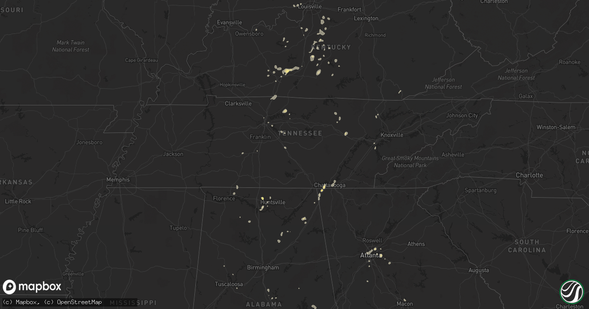
Hail Map in Tennessee on August 6, 2022
Get this storm
August 6 map
$229
one time, instant access
Download today. No call, no setup
Keep the $229
Bought the map and want the full workflow? Apply the entire $229 to a subscription within 7 days. None of it is wasted.
Every map, not just this one
This buys you this map. Subscription and you get every map we run, in the markets you choose from a few cities to whole states to nationwide. Plus real-time alerts the moment a storm fires.
Contact data
Name, contact info, occupancy, even credit band for addresses in the footprint. You go from where it hit to who to call.
Become the source they trust
Unlimited branding weather history reports on demand. You already have the documented answer ready for the property owner, and you are the one who showed up with it.
Property data and RoofTrace estimates
Pull up any address you have got, its value and the exact code rules for that jurisdiction, straight from One Click Code. Then RoofTrace estimates the squares, pitch, and roof value, priced the way you price.
Storm reports in Tennessee
Tennessee
| Date | Description |
|---|---|
| 08/06/20226:52 PM CDT | Tree down on battlefield trail. Time estimated from radar. |
| 08/06/20224:30 PM CDT | Tree down on campsite at melton hill dam campground. |
| 08/06/20223:51 PM CDT | Tree fell on vehicle at intersection of creekhead drive and piney grove church road. Time estimated from radar. |
| 08/06/20223:45 PM CDT | Tree down and some power lines across road at intersection of cain and lee road. Time estimated from radar. |
| 08/06/20223:45 PM CDT | Tree down on lines on deerwood road. Time estimated from radar. |
| 08/06/20223:35 PM CDT | Several trees downed... Blocking roads near pellissippi pkwy and solway rd. |
| 08/06/20223:15 PM CDT | Tree down in rutledge. Time estimated from radar. |
| 08/06/20222:30 PM CDT | Tree damage reported with one limb hitting a vehicle. Photos and report via twitter. Time estimated from radar. |
| 08/06/20222:30 PM CDT | Additional trees down in the sunset view neighborhood. Report via twitter... Time estimated by radar. |
| 08/05/202211:11 PM CDT | At 410 PM EDT, a severe thunderstorm was located 8 miles northeast of Maynardville, moving east at 10 mph. HAZARD...60 mph wind gusts and quarter size hail. SOURCE...Radar indicated. IMPACT...Hail damage to vehicles is expected. Expect wind damage to roofs, siding, and trees. Locations impacted include... Rutledge, New Tazewell, Tazewell, Luttrell, Lone Mountain, Joppa, Buffalo Springs, Sandlick and Panther Creek State Park. |
| 08/05/202210:33 PM CDT | At 333 PM CDT, a severe thunderstorm was located 11 miles southwest of Woodbury, moving southeast at 30 mph. HAZARD...60 mph wind gusts. SOURCE...Radar indicated. IMPACT...Expect damage to roofs, siding, and trees. Locations impacted include... McMinnville, Manchester, Morrison, Centertown, Bradyville, Beechgrove and Summitville.This includes Interstate 24 between mile markers 94 and 96, andbetween mile markers 99 and 112. |
| 08/05/20227:00 PM CDT | Tree down on a house on stallion lane. Time estimated by radar. |
All States Impacted by Hail Map on August 6, 2022
Cities Impacted by Hail Map on August 6, 2022
- West Point, KY
- Bardstown, KY
- Bloomfield, KY
- Taylorsville, KY
- Hanlontown, IA
- Fertile, IA
- Mason City, IA
- Clear Lake, IA
- Garner, IA
- Ventura, IA
- Forest City, IA
- Estherville, IA
- Arapahoe, CO
- Sheridan Lake, CO
- Rockwell, IA
- Lanesville, IN
- Georgetown, IN
- Chugwater, WY
- Las Animas, CO
- Hasty, CO
- McClave, CO
- Murfreesboro, TN
- Christiana, TN
- Denver, CO
- Denver, NC
- Simla, CO
- Calhan, CO
- Ramah, CO
- Limon, CO
- Matheson, CO
- Bowling Green, KY
- Campbellsville, KY
- Hampshire, TN
- Mount Pleasant, TN
- Decatur, GA
- Stone Mountain, GA
- Lithonia, GA
- Wisconsin Rapids, WI
- Olney Springs, CO
- Ordway, CO
- Coxs Creek, KY
- Corydon, IN
- Hodgenville, KY
- Nashville, TN
- Fort Gaines, GA
- Aurora, CO
- Radcliff, KY
- Fort Knox, KY
- Brooks, GA
- Horse Cave, KY
- Horton, AL
- Boaz, AL
- Altoona, AL
- Atlanta, GA
- Rush, CO
- New Haven, KY
- Woolstock, IA
- Blairsburg, IA
- Lu Verne, IA
- Livermore, IA
- Allison, IA
- Greene, IA
- Pine, CO
- Bailey, CO
- Elizabethtown, KY
- Hudson, KY
- Agate, CO
- Crossville, TN
- Athens, AL
- Harvest, AL
- Oneonta, AL
- Greenwood, FL
- Grand Ridge, FL
- Sneads, FL
- Andalusia, AL
- Glendo, WY
- Hartville, WY
- Wheatland, WY
- Kanawha, IA
- Clarion, IA
- Sheffield, IA
- Big Clifty, KY
- Belton, SC
- Freeport, FL
- Casper, WY
- Covington, GA
- Conyers, GA
- Cuthbert, GA
- Rutledge, AL
- Honoraville, AL
- Luverne, AL
- Elfrida, AZ
- Dunnville, KY
- Columbia, KY
- Jemison, AL
- Hawk Springs, WY
- Raywick, KY
- Wallingford, IA
- Buffalo, KY
- Wilder, TN
- Crawford, TN
- Clarkrange, TN
- Monterey, TN
- Round Lake, MN
- New Salisbury, IN
- Joice, IA
- Kensett, IA
- Rocky Ford, CO
- La Junta, CO
- Swink, CO
- Algona, IA
- Britt, IA
- Rockford, IA
- Marble Rock, IA
- Galt, IA
- Eagle Grove, IA
- Brewster, MN
- Worthington, MN
- Benton, WI
- Cuba City, WI
- Lascassas, TN
- Loretto, TN
- Lexington, AL
- Roundhill, KY
- Caryville, TN
- Ottosen, IA
- Bradgate, IA
- Bode, IA
- Humboldt, IA
- Rutland, IA
- Lime Springs, IA
- Elma, IA
- Magnolia, KY
- Cochise, AZ
- New Hope, KY
- Loretto, KY
- Berry, AL
- Hugo, CO
- Dublin, GA
- Kit Carson, CO
- Bethune, CO
- Burlington, CO
- Stratton, CO
- Vincent, IA
- Thor, IA
- Badger, IA
- Fitzgerald, GA
- Calera, AL
- Renwick, IA
- Hardy, IA
- Goldfield, IA
- Orrville, AL
- Glens Fork, KY
- Trenton, GA
- Lebanon, TN
- Troy, AL
- Summersville, KY
- Clanton, AL
- Collinsville, AL
- Lake Mills, IA
- Ider, AL
- Smiths Grove, KY
- Macon, GA
- Alpine, TN
- Ayrshire, IA
- Curlew, IA
- Emmetsburg, IA
- Haswell, CO
- Karval, CO
- Box Springs, GA
- Thornton, IA
- Bisbee, AZ
- Douglas, AZ
- Oakland, KY
- Castalian Springs, TN
- Shorterville, AL
- Leitchfield, KY
- Allred, TN
- Blakely, GA
- Camp Hill, AL
- Waverly, AL
- Goodwater, AL
- Mammoth Cave, KY
- Brownsville, KY
- Park City, KY
- Cave City, KY
- Lenoir City, TN
- Wildwood, GA
- McNeal, AZ
- Cottondale, AL
- Commerce City, CO
- Brighton, CO
- Henderson, CO
- Danville, AL
- Minter, AL
- Elgin, AZ
- Madison, AL
- Huntsville, AL
- Bethpage, TN
- Gallatin, TN
- Cottonwood, AL
- Riverdale, GA
- Fayetteville, GA
- Sumner, IA
- Fredericksburg, IA
- Bainbridge, GA
- Lebanon, KY
- Cheyenne Wells, CO
- Chattanooga, TN
- Edmonton, KY
- Knifley, KY
- Elk Horn, KY
- Hermitage, TN
- Dothan, AL
- Ashford, AL
- Greenville, AL
- Greensburg, KY
- Buena Vista, GA
- Mauk, GA
- Lewisport, KY
- Maceo, KY
- Tucker, GA
- Loudon, TN
- Rogersville, AL
- Killen, AL
- Yoder, CO
- Quitman, GA
- Ruthven, IA
- Whigham, GA
- Cheyenne, WY
- Jetson, KY
- Morgantown, KY
- Tuscaloosa, AL
- Blountstown, FL
- Banks, AL
- Junction City, GA
- Eastpoint, FL
- Avondale Estates, GA
- Auburn, KY
- Rebecca, GA
- Hixson, TN
- Ashburn, GA
- Sycamore, GA
- Fyffe, AL
- Fort Payne, AL
- Dawson, AL
- Moulton, AL
- Spring Hill, TN
- Columbia, TN
- Canmer, KY
- Kanorado, KS
- Abbeville, GA
- Marianna, FL
- Malone, FL
- Castleberry, AL
- Franklin, KY
- Portland, TN
- Cross Plains, TN
- Brewton, AL
- Norman Park, GA
- Moultrie, GA
- Flat Rock, AL
- Rising Fawn, GA
- Calvin, KY
- Pineville, KY
- Meservey, IA
- Klemme, IA
- Rockland, WI
- Bangor, WI
- Sparta, WI
- Cashton, WI
- Westby, WI
- Ontario, WI
- Norwalk, WI
- Trinidad, CO


