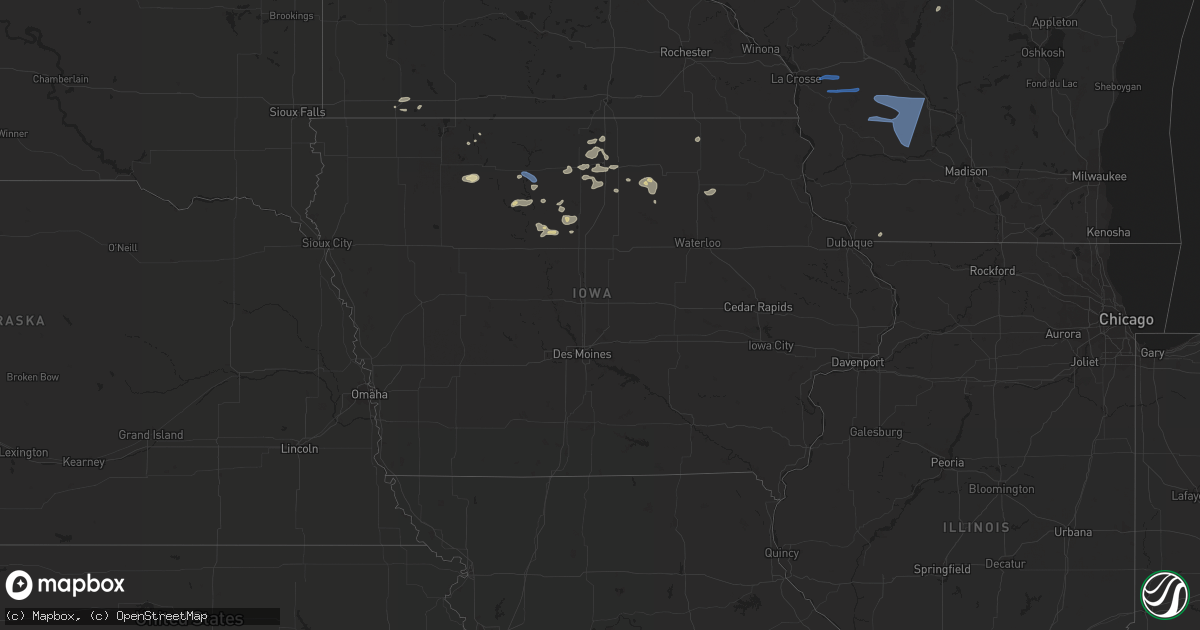
Hail Map in Iowa on August 6, 2022
Get this storm
August 6 map
$229
one time, instant access
Download today. No call, no setup
Keep the $229
Bought the map and want the full workflow? Apply the entire $229 to a subscription within 7 days. None of it is wasted.
Every map, not just this one
This buys you this map. Subscription and you get every map we run, in the markets you choose from a few cities to whole states to nationwide. Plus real-time alerts the moment a storm fires.
Contact data
Name, contact info, occupancy, even credit band for addresses in the footprint. You go from where it hit to who to call.
Become the source they trust
Unlimited branding weather history reports on demand. You already have the documented answer ready for the property owner, and you are the one who showed up with it.
Property data and RoofTrace estimates
Pull up any address you have got, its value and the exact code rules for that jurisdiction, straight from One Click Code. Then RoofTrace estimates the squares, pitch, and roof value, priced the way you price.
Storm reports in Iowa
Iowa
| Date | Description |
|---|---|
| 08/06/20226:04 PM CDT | Wind gust from personal weather station kialuver4. |
| 08/06/202212:57 AM CDT | At 557 PM CDT, a severe thunderstorm was located near Algona, moving east at 30 mph. HAZARD...60 mph wind gusts and penny size hail. SOURCE...Radar indicated. IMPACT...Expect damage to roofs, siding, and trees. This severe thunderstorm will be near... St. Benedict and Sexton around 605 PM CDT. Wesley around 610 PM CDT. Corwith around 615 PM CDT.Other locations in the path of this severe thunderstorm includeHutchins, Britt and Crystal Lake. |
| 08/06/202212:47 AM CDT | At 546 PM CDT, a severe thunderstorm was located 9 miles northwest of Humboldt, or 10 miles northwest of Dakota City, moving northeast at 20 mph. HAZARD...60 mph wind gusts and quarter size hail. SOURCE...Radar indicated. IMPACT...Hail damage to vehicles is expected. Expect wind damage to roofs, siding, and trees. This severe thunderstorm will be near... Bode around 550 PM CDT. Livermore around 600 PM CDT. St. Joseph around 605 PM CDT.Other locations in the path of this severe thunderstorm include LuVerne and Irvington. |
| 08/05/202211:57 PM CDT | At 457 PM CDT, a severe thunderstorm was located near Emmetsburg, moving east at 30 mph. HAZARD...60 mph wind gusts and nickel size hail. SOURCE...Radar indicated. IMPACT...Expect damage to roofs, siding, and trees. This severe thunderstorm will be near... Mallard around 500 PM CDT. Emmetsburg Municipal Airport around 505 PM CDT. Emmetsburg and Kearney State Park around 510 PM CDT.Other locations in the path of this severe thunderstorm includeCylinder, Rodman, West Bend, Whittemore and Stinson Prairie StatePark. |
All States Impacted by Hail Map on August 6, 2022
Cities Impacted by Hail Map on August 6, 2022
- West Point, KY
- Bardstown, KY
- Bloomfield, KY
- Taylorsville, KY
- Hanlontown, IA
- Fertile, IA
- Mason City, IA
- Clear Lake, IA
- Garner, IA
- Ventura, IA
- Forest City, IA
- Estherville, IA
- Arapahoe, CO
- Sheridan Lake, CO
- Rockwell, IA
- Lanesville, IN
- Georgetown, IN
- Chugwater, WY
- Las Animas, CO
- Hasty, CO
- McClave, CO
- Murfreesboro, TN
- Christiana, TN
- Denver, CO
- Denver, NC
- Simla, CO
- Calhan, CO
- Ramah, CO
- Limon, CO
- Matheson, CO
- Bowling Green, KY
- Campbellsville, KY
- Hampshire, TN
- Mount Pleasant, TN
- Decatur, GA
- Stone Mountain, GA
- Lithonia, GA
- Wisconsin Rapids, WI
- Olney Springs, CO
- Ordway, CO
- Coxs Creek, KY
- Corydon, IN
- Hodgenville, KY
- Nashville, TN
- Fort Gaines, GA
- Aurora, CO
- Radcliff, KY
- Fort Knox, KY
- Brooks, GA
- Horse Cave, KY
- Horton, AL
- Boaz, AL
- Altoona, AL
- Atlanta, GA
- Rush, CO
- New Haven, KY
- Woolstock, IA
- Blairsburg, IA
- Lu Verne, IA
- Livermore, IA
- Allison, IA
- Greene, IA
- Pine, CO
- Bailey, CO
- Elizabethtown, KY
- Hudson, KY
- Agate, CO
- Crossville, TN
- Athens, AL
- Harvest, AL
- Oneonta, AL
- Greenwood, FL
- Grand Ridge, FL
- Sneads, FL
- Andalusia, AL
- Glendo, WY
- Hartville, WY
- Wheatland, WY
- Kanawha, IA
- Clarion, IA
- Sheffield, IA
- Big Clifty, KY
- Belton, SC
- Freeport, FL
- Casper, WY
- Covington, GA
- Conyers, GA
- Cuthbert, GA
- Rutledge, AL
- Honoraville, AL
- Luverne, AL
- Elfrida, AZ
- Dunnville, KY
- Columbia, KY
- Jemison, AL
- Hawk Springs, WY
- Raywick, KY
- Wallingford, IA
- Buffalo, KY
- Wilder, TN
- Crawford, TN
- Clarkrange, TN
- Monterey, TN
- Round Lake, MN
- New Salisbury, IN
- Joice, IA
- Kensett, IA
- Rocky Ford, CO
- La Junta, CO
- Swink, CO
- Algona, IA
- Britt, IA
- Rockford, IA
- Marble Rock, IA
- Galt, IA
- Eagle Grove, IA
- Brewster, MN
- Worthington, MN
- Benton, WI
- Cuba City, WI
- Lascassas, TN
- Loretto, TN
- Lexington, AL
- Roundhill, KY
- Caryville, TN
- Ottosen, IA
- Bradgate, IA
- Bode, IA
- Humboldt, IA
- Rutland, IA
- Lime Springs, IA
- Elma, IA
- Magnolia, KY
- Cochise, AZ
- New Hope, KY
- Loretto, KY
- Berry, AL
- Hugo, CO
- Dublin, GA
- Kit Carson, CO
- Bethune, CO
- Burlington, CO
- Stratton, CO
- Vincent, IA
- Thor, IA
- Badger, IA
- Fitzgerald, GA
- Calera, AL
- Renwick, IA
- Hardy, IA
- Goldfield, IA
- Orrville, AL
- Glens Fork, KY
- Trenton, GA
- Lebanon, TN
- Troy, AL
- Summersville, KY
- Clanton, AL
- Collinsville, AL
- Lake Mills, IA
- Ider, AL
- Smiths Grove, KY
- Macon, GA
- Alpine, TN
- Ayrshire, IA
- Curlew, IA
- Emmetsburg, IA
- Haswell, CO
- Karval, CO
- Box Springs, GA
- Thornton, IA
- Bisbee, AZ
- Douglas, AZ
- Oakland, KY
- Castalian Springs, TN
- Shorterville, AL
- Leitchfield, KY
- Allred, TN
- Blakely, GA
- Camp Hill, AL
- Waverly, AL
- Goodwater, AL
- Mammoth Cave, KY
- Brownsville, KY
- Park City, KY
- Cave City, KY
- Lenoir City, TN
- Wildwood, GA
- McNeal, AZ
- Cottondale, AL
- Commerce City, CO
- Brighton, CO
- Henderson, CO
- Danville, AL
- Minter, AL
- Elgin, AZ
- Madison, AL
- Huntsville, AL
- Bethpage, TN
- Gallatin, TN
- Cottonwood, AL
- Riverdale, GA
- Fayetteville, GA
- Sumner, IA
- Fredericksburg, IA
- Bainbridge, GA
- Lebanon, KY
- Cheyenne Wells, CO
- Chattanooga, TN
- Edmonton, KY
- Knifley, KY
- Elk Horn, KY
- Hermitage, TN
- Dothan, AL
- Ashford, AL
- Greenville, AL
- Greensburg, KY
- Buena Vista, GA
- Mauk, GA
- Lewisport, KY
- Maceo, KY
- Tucker, GA
- Loudon, TN
- Rogersville, AL
- Killen, AL
- Yoder, CO
- Quitman, GA
- Ruthven, IA
- Whigham, GA
- Cheyenne, WY
- Jetson, KY
- Morgantown, KY
- Tuscaloosa, AL
- Blountstown, FL
- Banks, AL
- Junction City, GA
- Eastpoint, FL
- Avondale Estates, GA
- Auburn, KY
- Rebecca, GA
- Hixson, TN
- Ashburn, GA
- Sycamore, GA
- Fyffe, AL
- Fort Payne, AL
- Dawson, AL
- Moulton, AL
- Spring Hill, TN
- Columbia, TN
- Canmer, KY
- Kanorado, KS
- Abbeville, GA
- Marianna, FL
- Malone, FL
- Castleberry, AL
- Franklin, KY
- Portland, TN
- Cross Plains, TN
- Brewton, AL
- Norman Park, GA
- Moultrie, GA
- Flat Rock, AL
- Rising Fawn, GA
- Calvin, KY
- Pineville, KY
- Meservey, IA
- Klemme, IA
- Rockland, WI
- Bangor, WI
- Sparta, WI
- Cashton, WI
- Westby, WI
- Ontario, WI
- Norwalk, WI
- Trinidad, CO


