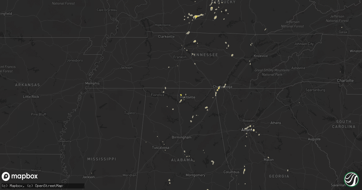
Hail Map on August 6, 2022
Get this storm
August 6 map
$229
one time, instant access
Download today. No call, no setup
Keep the $229
Bought the map and want the full workflow? Apply the entire $229 to a subscription within 7 days. None of it is wasted.
Every map, not just this one
This buys you this map. Subscription and you get every map we run, in the markets you choose from a few cities to whole states to nationwide. Plus real-time alerts the moment a storm fires.
Contact data
Name, contact info, occupancy, even credit band for addresses in the footprint. You go from where it hit to who to call.
Become the source they trust
Unlimited branding weather history reports on demand. You already have the documented answer ready for the property owner, and you are the one who showed up with it.
Property data and RoofTrace estimates
Pull up any address you have got, its value and the exact code rules for that jurisdiction, straight from One Click Code. Then RoofTrace estimates the squares, pitch, and roof value, priced the way you price.
States Impacted by Hail Map on August 6, 2022
Storm reports
South Dakota
| Date | Description |
|---|---|
| 08/05/20228:19 PM CDT | At 118 AM CDT, a severe thunderstorm was located near Odessa, or 9 miles east of Ortonville, moving east at 20 mph. HAZARD...60 mph wind gusts and quarter size hail. SOURCE...Radar indicated. IMPACT...Hail damage to vehicles is expected. Expect wind damage to roofs, siding, and trees. This severe thunderstorm will be near... Correll and Artichoke Lake around 135 AM CDT. |
| 08/05/20228:02 PM CDT | At 101 AM CDT, a severe thunderstorm was located near Odessa, or 9 miles southeast of Ortonville, moving east at 35 mph. HAZARD...60 mph wind gusts and quarter size hail. SOURCE...Radar indicated. IMPACT...Hail damage to vehicles is expected. Expect wind damage to roofs, siding, and trees. Locations impacted include... Appleton and Milan. |
Georgia
| Date | Description |
|---|---|
| 08/06/20225:30 PM CDT | Tree and powerline down in buena vista. |
| 08/06/20222:23 AM CDT | At 723 PM EDT, a severe thunderstorm was located near Chattanooga, moving northeast at 5 mph. HAZARD...60 mph wind gusts and penny size hail. SOURCE...Radar indicated. IMPACT...Expect damage to roofs, siding, and trees. Locations impacted include... Chattanooga, Soddy-Daisy, Lakesite, Ridgeside, Harrison, Red Bank, East Brainerd, Lookout Mountain, Harrison Bay State Park and East Ridge.This includes Interstate 75 in Tennessee between mile markers 1 and10. |
| 08/06/20221:29 AM CDT | At 628 PM EDT, a severe thunderstorm was located over Trenton, and is nearly stationary. HAZARD...60 mph wind gusts and quarter size hail. SOURCE...Radar indicated. IMPACT...Hail damage to vehicles is expected. Expect wind damage to roofs, siding, and trees. Locations impacted include... Trenton, Stephensville, Rising Fawn, New England, Morganville, Hooker, Cloudland Canyon State Park, Cole City and Wildwood. |
| 08/06/20221:22 AM CDT | At 622 PM EDT, a severe thunderstorm was located near Marion Estates, or 11 miles south of Talbotton, moving northwest at 5 mph. HAZARD...60 mph wind gusts and quarter size hail. SOURCE...Radar indicated. IMPACT...Hail damage to vehicles is expected. Expect wind damage to roofs, siding, and trees. Locations impacted include... Junction City, Geneva, Marion Estates and Oakland. |
New Hampshire
| Date | Description |
|---|---|
| 08/06/20225:15 PM CDT | Social media post and photos of numerous branches down on wilkinson swamp rd. 2 small trees knocked down as well. Reports of small hail. Time estimated by radar. |
| 08/06/20224:20 PM CDT | Thunderstorm winds knocked down several branches near suncook river and rte 126. Time estimated by radar. |
| 08/06/20221:36 AM CDT | At 636 PM EDT, a severe thunderstorm was located near Cornish, or 13 miles northeast of Ossipee, moving northeast at 20 mph. HAZARD...60 mph wind gusts and penny size hail. SOURCE...Radar indicated. IMPACT...Expect damage to roofs, siding, and trees. Locations impacted include... Bridgton, Hiram, Cornish, Standish, Limington, Limerick, Denmark, Parsonsfield, Baldwin, Porter and Sebago. |
North Carolina
| Date | Description |
|---|---|
| 08/06/20224:15 PM CDT | Reports of trees down in the statesville area. Time estimated from radar. |
| 08/06/20223:45 PM CDT | Three trees down at hwy 152 and saw rd. |
| 08/06/20223:35 PM CDT | Tree on power lines on white rd. |
| 08/06/20223:21 PM CDT | Report of a tree through house on river rd. A couple other trees down on the 3700 block of river rd. |
| 08/06/20223:10 PM CDT | Three large tree limbs were snapped along wallburg road near the davidson and forsyth county lines. |
| 08/06/20221:09 AM CDT | At 608 PM EDT, a severe thunderstorm was located 9 miles southeast of Smithfield, moving northwest at 10 mph. HAZARD...60 mph wind gusts and penny size hail. SOURCE...Radar indicated. IMPACT...Expect damage to roofs, siding, and trees. Locations impacted include... Smithfield, Micro, Selma, Four Oaks, Pine Level, Kenly, Princeton and Nahunta. |
| 08/06/20221:04 AM CDT | At 603 PM EDT, a severe thunderstorm was located near Elm City, or near Rocky Mount, moving northwest at 15 mph. HAZARD...60 mph wind gusts and penny size hail. SOURCE...Radar indicated. IMPACT...Expect damage to roofs, siding, and trees. Locations impacted include... Rocky Mount, Nashville, Wilson, Elm City, Dortches, Red Oak, Sharpsburg, Spring Hope, Castalia and Tar River Reservoir. |
| 08/06/202212:20 AM CDT | At 520 PM EDT, a severe thunderstorm was located near Mocksville, moving northwest at 10 mph. HAZARD...60 mph wind gusts and penny size hail. SOURCE...Radar indicated. IMPACT...Expect damage to trees and power lines. Locations impacted include... Mocksville, Cooleemee, Harmony, Fork Church, Sheffield, Farmington, Woodleaf, Turnersburg, Olin and Cool Springs. |
| 08/05/202211:59 PM CDT | At 459 PM EDT, a severe thunderstorm was located 6 miles east of Statesville, or 5 miles northwest of Cleveland, moving northeast at 5 mph. HAZARD...60 mph wind gusts and penny size hail. SOURCE...Radar indicated. IMPACT...Expect damage to trees and power lines. Locations impacted include... Statesville, Cleveland, Mount Ulla, Woodleaf, Cool Springs and Piedmont Research Station. |
Iowa
| Date | Description |
|---|---|
| 08/06/20226:04 PM CDT | Wind gust from personal weather station kialuver4. |
| 08/06/202212:57 AM CDT | At 557 PM CDT, a severe thunderstorm was located near Algona, moving east at 30 mph. HAZARD...60 mph wind gusts and penny size hail. SOURCE...Radar indicated. IMPACT...Expect damage to roofs, siding, and trees. This severe thunderstorm will be near... St. Benedict and Sexton around 605 PM CDT. Wesley around 610 PM CDT. Corwith around 615 PM CDT.Other locations in the path of this severe thunderstorm includeHutchins, Britt and Crystal Lake. |
| 08/06/202212:47 AM CDT | At 546 PM CDT, a severe thunderstorm was located 9 miles northwest of Humboldt, or 10 miles northwest of Dakota City, moving northeast at 20 mph. HAZARD...60 mph wind gusts and quarter size hail. SOURCE...Radar indicated. IMPACT...Hail damage to vehicles is expected. Expect wind damage to roofs, siding, and trees. This severe thunderstorm will be near... Bode around 550 PM CDT. Livermore around 600 PM CDT. St. Joseph around 605 PM CDT.Other locations in the path of this severe thunderstorm include LuVerne and Irvington. |
| 08/05/202211:57 PM CDT | At 457 PM CDT, a severe thunderstorm was located near Emmetsburg, moving east at 30 mph. HAZARD...60 mph wind gusts and nickel size hail. SOURCE...Radar indicated. IMPACT...Expect damage to roofs, siding, and trees. This severe thunderstorm will be near... Mallard around 500 PM CDT. Emmetsburg Municipal Airport around 505 PM CDT. Emmetsburg and Kearney State Park around 510 PM CDT.Other locations in the path of this severe thunderstorm includeCylinder, Rodman, West Bend, Whittemore and Stinson Prairie StatePark. |
Missouri
| Date | Description |
|---|---|
| 08/06/20226:05 PM CDT | Delayed report: a localized downburst downed trees at highway 42 and bear creek road as well as highway 42 and highway 134. Road was blocked. Trees were also downed at |
Kentucky
| Date | Description |
|---|---|
| 08/06/20223:01 PM CDT | Couple of trees down. |
| 08/06/20222:23 PM CDT | Reported via mping. |
| 08/05/202211:14 PM CDT | At 414 PM EDT, severe thunderstorms were located along a line extending from near Taylorsville to 6 miles north of Bardstown, moving south at 15 mph. HAZARD...60 mph wind gusts. SOURCE...Radar indicated. IMPACT...Expect damage to roofs, siding, and trees. Locations impacted include... Taylorsville, Bloomfield, Wakefield, Chaplin and Coxs Creek. |
| 08/05/202210:58 PM CDT | At 357 PM EDT, severe thunderstorms were from 8 miles southwest of Taylorsville to 9 miles south of Shepherdsville, moving east at 10 mph. HAZARD...60 mph wind gusts. SOURCE...Radar indicated. IMPACT...Expect damage to roofs, siding, and trees. These severe thunderstorms will affect the following locations... Samuels, Ridgetop, Highgrove, Solitude, Hobbs, Scuffletown, Deatsville, Brownington, Lotus, and Lenore. |
| 08/05/202210:52 PM CDT | At 352 PM EDT, a severe thunderstorm was located near Taylorsville, moving northeast at 15 mph. HAZARD...60 mph wind gusts. SOURCE...Radar indicated. IMPACT...Expect damage to roofs, siding, and trees. Locations impacted include... Taylorsville, Yoder, Normandy, Elk Creek and Waterford. |
| 08/05/20229:39 PM CDT | At 238 PM CDT, severe thunderstorms were from 7 miles southeast of Brownsville to 9 miles north of Glasgow, moving east at 45 mph. HAZARD...60 mph wind gusts and quarter size hail. SOURCE...Radar indicated. IMPACT...Hail damage to vehicles is expected. Expect wind damage to roofs, siding, and trees. Locations impacted include... Brownsville, Horse Cave, Chalybeate, Rowletts, Logsdon Valley, Straw, Mammoth Cave, Northtown, Legrande, and Uno. |
| 08/05/20229:09 PM CDT | At 209 PM CDT, severe thunderstorms were from 8 miles west of Brownsville to 9 miles east of Plum Springs, moving east at 20 mph. HAZARD...60 mph wind gusts and quarter size hail. SOURCE...Radar indicated. IMPACT...Hail damage to vehicles is expected. Expect wind damage to roofs, siding, and trees. Locations impacted include... Brownsville. |
Alabama
| Date | Description |
|---|---|
| 08/06/20224:34 PM CDT | Trees down at weoka road and antioch road. Time estimated from radar. |
| 08/06/20224:05 PM CDT | Half dollar sized hail was reported. |
| 08/06/20224:05 PM CDT | Shingles knocked off of roof near east limestone and nick davis rds. Also hail to one-half dollar in size was reported. |
| 08/06/20223:35 PM CDT | Powerlines reported down on teton drive. |
| 08/06/20223:34 PM CDT | A tree fell down on powerlines on juniper drive. |
| 08/05/202211:02 PM CDT | At 402 PM CDT, a severe thunderstorm was located near Harvest, or 7 miles northwest of Madison, and is nearly stationary. HAZARD...60 mph wind gusts. SOURCE...Radar indicated. IMPACT...Expect damage to roofs, siding, and trees. Locations impacted include... Northern Huntsville, Harvest and Capshaw. |
| 08/05/202210:48 PM CDT | At 348 PM CDT, a severe thunderstorm was located over Huntsville International Airport, or near Madison, moving northeast at 10 mph. HAZARD...60 mph wind gusts. SOURCE...Radar indicated. IMPACT...Expect damage to roofs, siding, and trees. Locations impacted include... Western Huntsville, Madison, Redstone Arsenal, Triana, Marshall Space Flight Center, Huntsville International Airport, Mooresville and Belle Mina. |
| 08/05/20229:41 PM CDT | At 240 PM CDT, a severe thunderstorm was located over Cottonwood, moving west at 15 mph. HAZARD...60 mph wind gusts and penny size hail. SOURCE...Radar indicated. IMPACT...Expect damage to roofs, siding, and trees. Locations impacted include... Cottonwood, Graceville, Taylor, Slocomb, Malone, Malvern, Rehobeth, Greenwood, Madrid, Campbellton, Memphis, Grangeburg, Garretts Crossroads, Tendil Crossing, Southern Junction, Merritts Crossroads, Keytons, Light, Cobb Crossroads and Jacobs. |
| 08/05/20227:55 PM CDT | Emergency manager received a report of several trees down along cr135 in southwest autauga county. Time estimated by radar. |
Colorado
| Date | Description |
|---|---|
| 08/06/20225:06 AM CDT | At 1006 PM MDT, a severe thunderstorm was located 17 miles north of Cheyenne Wells, moving northeast at 10 mph. HAZARD...60 mph wind gusts and quarter size hail. SOURCE...Radar indicated. IMPACT...Hail damage to vehicles is expected. Expect wind damage to roofs, siding, and trees. This severe thunderstorm will remain over mainly rural areas of northeastern Cheyenne and southeastern Kit Carson Counties in east central Colorado, northwestern Wallace County in west central Kansas and southwestern Sherman Counties in northwestern Kansas.This includes the following highways... Interstate 70 in Kansas between mile markers 0 and 4. Interstate 70 in Colorado between mile markers 436 and 450. Highway 385 between mile markers 163 and 190. |
| 08/06/20222:31 AM CDT | At 731 PM MDT, a severe thunderstorm was located 6 miles northwest of Hugo, or 8 miles southeast of Limon, moving east at 15 mph. HAZARD...60 mph wind gusts and penny size hail. SOURCE...Radar indicated. IMPACT...Expect damage to roofs, siding, and trees. Locations impacted include... Hugo and Genoa. |
| 08/06/20222:02 AM CDT | At 701 PM MDT, a severe thunderstorm was located 11 miles south of Limon, moving northeast at 20 mph. HAZARD...70 mph wind gusts and ping pong ball size hail. SOURCE...Radar indicated. IMPACT...Expect considerable tree damage. Damage is likely to mobile homes, roofs, and outbuildings. People and animals outdoors will be injured. Expect hail damage to roofs, siding, windows, and vehicles. Hail may accumulate on roadways causing hazardous travel. Locations impacted include... Limon and Hugo. |
| 08/06/20221:37 AM CDT | At 637 PM MDT, a severe thunderstorm was located 9 miles southeast of Matheson, or 17 miles southwest of Limon, moving northeast at 20 mph. HAZARD...Ping pong ball size hail and 60 mph wind gusts. SOURCE...Radar indicated. IMPACT...Expect damage to roofs, siding, and trees. People and animals outdoors will be injured. Expect hail damage to roofs, siding, windows, and vehicles. Hail may accumulate on roadways causing hazardous travel. This severe thunderstorm will remain over mainly rural areas of southeastern Elbert and central Lincoln Counties between Kutch and Limon. |
| 08/06/20221:27 AM CDT | At 625 PM MDT, severe thunderstorms were located along a line extending from near Blue Lake to 6 miles northwest of John Martin Reservoir to 15 miles south of Las Animas, moving east at 45 mph. HAZARD...70 mph wind gusts and quarter size hail. SOURCE...Radar indicated. These storms have a history of producing severe winds. IMPACT...Hail damage to vehicles is expected. Expect considerable tree damage. Wind damage is also likely to mobile homes, roofs, and outbuildings. Locations impacted include... Las Animas, Haswell, Blue Lake, Hasty, Arlington, John Martin Reservoir, Fort Lyon and Caddoa. |
| 08/06/202212:43 AM CDT | At 542 PM MDT, a severe thunderstorm was located 13 miles west of Forder, or 43 miles northeast of Pueblo, moving west at 5 mph. HAZARD...60 mph wind gusts and half dollar size hail. SOURCE...Radar indicated. IMPACT...Expect damage to roofs, siding, and trees. Hail damage to vehicles is expected. This severe thunderstorm will remain over mainly rural areas of southwestern Lincoln County west of Forder. |
| 08/06/202212:40 AM CDT | At 539 PM MDT, severe thunderstorms were located along a line extending from 12 miles southwest of Wild Horse Point to near Rocky Ford to 7 miles south of North La Junta, moving northeast at 15 mph. HAZARD...60 mph wind gusts and quarter size hail. SOURCE...Radar indicated. IMPACT...Hail damage to vehicles is expected. Expect wind damage to roofs, siding, and trees. Locations impacted include... La Junta, North La Junta, Rocky Ford, Ordway, Swink, Sugar City, Cheraw and Higbee. |
| 08/05/20227:30 PM CDT | Shingles off the roofs of houses. |
| 08/05/20227:11 PM CDT | Corrects time on previous tstm wnd dmg report from la junta. Power pole blown down. |
| 08/05/20227:07 PM CDT | Reported by lhx asos. |
| 08/05/20227:05 PM CDT | 2 power poles blown down. |
| 08/05/20227:05 PM CDT | Power pole blown down. |
Arizona
| Date | Description |
|---|---|
| 08/06/20224:09 AM CDT | At 908 PM MST, a severe thunderstorm was located near East Sahuarita, or 7 miles east of Sahuarita, moving west at 40 mph. HAZARD...60 mph wind gusts and penny size hail. SOURCE...Radar indicated. IMPACT...Expect damage to roofs, siding, and trees. Locations impacted include... Tucson, Sahuarita, Green Valley, Davis-Monthan Air Force Base, Casas Adobes, Drexel Heights, Flowing Wells, Tanque Verde, Vail, South Tucson, Three Points, Pascua Pueblo Yaqui Reservation, East Sahuarita, Sonoita, Elgin, Sabino Canyon Recreation Area, Summit, Tucson Estates, Saguaro National Park West and Valencia West. |
| 08/06/20223:00 AM CDT | At 759 PM MST, a cluster of severe thunderstorms were located over Dragoon, or 17 miles southwest of Willcox, moving west at 25 mph. HAZARD...60 mph wind gusts and quarter size hail. SOURCE...Radar indicated. IMPACT...Hail damage to vehicles is expected. Expect wind damage to roofs, siding, and trees. Locations impacted include... Benson, St. David, Dragoon, Pearce-Sunsites, Cochise, Texas Canyon and Cascabel. |
| 08/06/20222:50 AM CDT | At 750 PM MST, a severe thunderstorm was located near Elgin, or 20 miles west of Sierra Vista, moving west at 25 mph. HAZARD...60 mph wind gusts and quarter size hail. SOURCE...Radar indicated. IMPACT...Hail damage to vehicles is expected. Expect wind damage to roofs, siding, and trees. Locations impacted include... Patagonia, Sonoita, Elgin, Fort Huachuca and Canelo. |
| 08/06/20222:27 AM CDT | At 727 PM MST, a severe thunderstorm was located over Tombstone, or 18 miles northeast of Sierra Vista, moving west at 25 mph. HAZARD...60 mph wind gusts and quarter size hail. SOURCE...Radar indicated. IMPACT...Hail damage to vehicles is expected. Expect wind damage to roofs, siding, and trees. Locations impacted include... Sierra Vista, Whetstone, Huachuca City, St. David, Tombstone, Kartchner Caverns State Park, Fort Huachuca, Fairbank and Charleston. |
| 08/06/20221:51 AM CDT | At 651 PM MST, a severe thunderstorm was located 13 miles southeast of Tombstone, or 15 miles north of Bisbee, moving west at 25 mph. HAZARD...60 mph wind gusts and quarter size hail. SOURCE...Radar indicated. IMPACT...Hail damage to vehicles is expected. Expect wind damage to roofs, siding, and trees. Locations impacted include... Sierra Vista, Tombstone, Elfrida, Sunizona and Charleston. |
| 08/06/202212:58 AM CDT | At 557 PM MST, severe thunderstorms were located along a line extending from 9 miles southwest of Portal to 23 miles north of Douglas to 7 miles east of Bisbee-Douglas Airport, moving west at 25 mph. HAZARD...60 mph wind gusts and quarter size hail. SOURCE...Radar indicated. IMPACT...Hail damage to vehicles is expected. Expect wind damage to roofs, siding, and trees. Locations impacted include... Douglas, Portal, Bisbee-Douglas Airport, Pirtleville, Elfrida, McNeal and Rucker Canyon. |
| 08/05/202211:23 PM CDT | Asos measured gust of 60mph in east tucson. |
| 08/05/202211:15 PM CDT | Corrects previous tstm wnd gst report from 6 ssw tucson. Asos repor |
| 08/05/202211:15 PM CDT | Corrects previ |
| 08/05/202211:15 PM CDT | Corrects previous tstm wnd gst report from 6 ssw tucson. Asos reported 59mph at 9:10pm update: gusts at 60mph at 9:16pm. |
| 08/05/202211:10 PM CDT | Asos reported 59mph at 9:10pm. |
| 08/05/20229:00 PM CDT | Lines are down across the road causing road closures. Radar indicated reported by cochise sheriffs office. |
Nevada
| Date | Description |
|---|---|
| 08/05/202210:14 PM CDT | At 314 PM PDT, a severe thunderstorm was located 32 miles east of McDermitt, moving east at 25 mph. HAZARD...60 mph wind gusts and quarter size hail. SOURCE...Radar indicated. IMPACT...Hail damage to vehicles is expected. Expect wind damage to roofs, siding, and trees. This severe thunderstorm will remain over mainly rural areas of northeastern Humboldt and northwestern Elko Counties. |
Maryland
| Date | Description |
|---|---|
| 08/06/20224:50 PM CDT | Several trees blew down near little orleans. A tree blew down onto westbound i-68 national freeway at mile marker 65. A tree blew down along dug hill road. |
Wyoming
| Date | Description |
|---|---|
| 08/06/20226:40 PM CDT | Severe t-storm wind gust to 66 mph on wy dot mesonet i-80 at french. |
| 08/06/20226:22 PM CDT | Severe t-storm wind gust to 68 mph on wy dot mesonet site at i-80/first divide. |
| 08/06/202212:41 AM CDT | At 539 PM MDT, a severe thunderstorm was located near Mountain View, or 27 miles east of Evanston, moving northeast at 40 mph. HAZARD...60 mph wind gusts and quarter size hail. SOURCE...Radar indicated with winds confirmed by a mesonet observation. IMPACT...Hail damage to vehicles is expected. Expect wind damage to roofs, siding, and trees. Locations impacted include... Lyman, Robertson, Mountain View, Millburne, Church Buttes, Fort Bridger and Carter.This includes Interstate 80 in Wyoming between mile markers 26 and56. |
| 08/06/202212:14 AM CDT | At 513 PM MDT, a severe thunderstorm was located 14 miles northeast of Whitaker, or 28 miles north of Cheyenne, moving east at 10 mph. HAZARD...60 mph wind gusts and quarter size hail. SOURCE...Radar indicated. IMPACT...Hail damage to vehicles is expected. Expect wind damage to roofs, siding, and trees. This severe thunderstorm will remain over mainly rural areas of southwestern Goshen, north central Laramie and southeastern Platte Counties. |
| 08/05/202211:33 PM CDT | At 432 PM MDT, a severe thunderstorm was located 10 miles north of Whitaker, or 28 miles north of Cheyenne, moving northeast at 10 mph. HAZARD...60 mph wind gusts and quarter size hail. SOURCE...Radar indicated. IMPACT...Hail damage to vehicles is expected. Expect wind damage to roofs, siding, and trees. This severe thunderstorm will remain over mainly rural areas of southwestern Goshen, north central Laramie and southeastern Platte Counties.This includes Interstate 25 in Wyoming between mile markers 37 and50. |
| 08/05/202210:50 PM CDT | At 349 PM MDT, a severe thunderstorm was located 12 miles east of Teapot Rock, or 26 miles northeast of Casper, moving east at 40 mph. HAZARD...60 mph wind gusts and half dollar size hail. SOURCE...Radar indicated. IMPACT...Hail damage to vehicles is expected. Expect wind damage to roofs, siding, and trees. This severe thunderstorm will remain over mainly rural areas of northwestern Converse County. |
| 08/05/202210:38 PM CDT | At 337 PM MDT, a severe thunderstorm was located near Teapot Rock, or 25 miles north of Casper, moving east at 40 mph. HAZARD...Ping pong ball size hail and 60 mph wind gusts. SOURCE...Radar indicated. IMPACT...People and animals outdoors will be injured. Expect hail damage to roofs, siding, windows, and vehicles. Expect wind damage to roofs, siding, and trees. This severe thunderstorm will remain over mainly rural areas of east central Natrona County. |
| 08/05/202210:02 PM CDT | At 302 PM MDT, a severe thunderstorm was located 9 miles northeast of Goldeneye Reservoir, or 24 miles northwest of Casper, moving east at 30 mph. HAZARD...60 mph wind gusts and quarter size hail. SOURCE...Radar indicated. IMPACT...Hail damage to vehicles is expected. Expect wind damage to roofs, siding, and trees. Locations impacted include... Antelope Hills and Teapot Rock.This includes Interstate 25 between mile markers 200 and 217. |
| 08/05/20229:19 PM CDT | At 218 PM MDT, a severe thunderstorm was located near Powder River, or 38 miles northwest of Casper, moving east at 40 mph. HAZARD...60 mph wind gusts and quarter size hail. SOURCE...Radar indicated. IMPACT...Hail damage to vehicles is expected. Expect wind damage to roofs, siding, and trees. This severe thunderstorm will remain over mainly rural areas of central Natrona County, including the following locations... Natrona. |
Virginia
| Date | Description |
|---|---|
| 08/06/20221:58 PM CDT | A tree was downed by thunderstorm winds near the intersection of millstone road and harrison ridge road. |
| 08/06/20221:44 PM CDT | A tree was downed by thunderstorm winds near the intersection of forest oak road and elk horn road. |
| 08/06/20221:26 PM CDT | A tree was downed by thunderstorm winds near the intersection of north fork road and roanoke road. |
| 08/06/202212:59 PM CDT | A tree was downed by thunderstorm winds near the intersection of georges run road and lizard creek road. |
| 08/06/202212:44 PM CDT | Tree down along georges run road. Time estimated by radar. |
| 08/06/202212:36 PM CDT | A tree was downed by thunderstorm winds near the intersection of tower road and glade drive. |
| 08/06/202212:20 PM CDT | Several trees blown down on wilderness road brought down power lines. |
| 08/06/202212:18 PM CDT | A tree was downed by thunderstorm winds near the intersection of state park road and wilderness road. |
| 08/05/20228:36 PM CDT | At 135 PM EDT, a severe thunderstorm was located over Sylvatus, or near Patterson, moving northeast at 15 mph. HAZARD...60 mph wind gusts. SOURCE...Radar indicated. IMPACT...Expect damage to roofs, siding, and trees. Locations impacted include... Hillsville... Indian Valley... Patterson... Allisonia... Sylvatus... and Claytor Lake State Park. |
| 08/05/20228:28 PM CDT | At 128 PM EDT, a severe thunderstorm was located over Radford, moving northeast at 20 mph. HAZARD...60 mph wind gusts. SOURCE...Radar indicated. IMPACT...Expect damage to roofs, siding, and trees. Locations impacted include... Blacksburg... Christiansburg... Radford... Prices Fork... Claytor Dam... Fairlawn... and Graysontown. |
Minnesota
| Date | Description |
|---|---|
| 08/06/20227:11 AM CDT | At 1211 AM CDT, a severe thunderstorm was located over Marvin, or 8 miles southwest of Wilmot, moving east at 30 mph. HAZARD...60 mph wind gusts and quarter size hail. SOURCE...Radar indicated. IMPACT...Hail damage to vehicles is expected. Expect wind damage to roofs, siding, and trees. This severe thunderstorm will be near... Corona and Twin Brooks around 1225 AM CDT.Other locations in the path of this severe thunderstorm includeMilbank, Lagoona Beach, Big Stone City and Ortonville. |
| 08/05/20228:15 PM CDT | At 115 AM CDT, a severe thunderstorm was located 8 miles southeast of Milbank, moving east at 20 mph. HAZARD...60 mph wind gusts and quarter size hail. SOURCE...Radar indicated. IMPACT...Hail damage to vehicles is expected. Expect wind damage to roofs, siding, and trees. This severe thunderstorm will remain over mainly rural areas of southeastern Grant County. |
Tennessee
| Date | Description |
|---|---|
| 08/06/20226:52 PM CDT | Tree down on battlefield trail. Time estimated from radar. |
| 08/06/20224:30 PM CDT | Tree down on campsite at melton hill dam campground. |
| 08/06/20223:51 PM CDT | Tree fell on vehicle at intersection of creekhead drive and piney grove church road. Time estimated from radar. |
| 08/06/20223:45 PM CDT | Tree down and some power lines across road at intersection of cain and lee road. Time estimated from radar. |
| 08/06/20223:45 PM CDT | Tree down on lines on deerwood road. Time estimated from radar. |
| 08/06/20223:35 PM CDT | Several trees downed... Blocking roads near pellissippi pkwy and solway rd. |
| 08/06/20223:15 PM CDT | Tree down in rutledge. Time estimated from radar. |
| 08/06/20222:30 PM CDT | Additional trees down in the sunset view neighborhood. Report via twitter... Time estimated by radar. |
| 08/06/20222:30 PM CDT | Tree damage reported with one limb hitting a vehicle. Photos and report via twitter. Time estimated from radar. |
| 08/05/202211:11 PM CDT | At 410 PM EDT, a severe thunderstorm was located 8 miles northeast of Maynardville, moving east at 10 mph. HAZARD...60 mph wind gusts and quarter size hail. SOURCE...Radar indicated. IMPACT...Hail damage to vehicles is expected. Expect wind damage to roofs, siding, and trees. Locations impacted include... Rutledge, New Tazewell, Tazewell, Luttrell, Lone Mountain, Joppa, Buffalo Springs, Sandlick and Panther Creek State Park. |
| 08/05/202210:33 PM CDT | At 333 PM CDT, a severe thunderstorm was located 11 miles southwest of Woodbury, moving southeast at 30 mph. HAZARD...60 mph wind gusts. SOURCE...Radar indicated. IMPACT...Expect damage to roofs, siding, and trees. Locations impacted include... McMinnville, Manchester, Morrison, Centertown, Bradyville, Beechgrove and Summitville.This includes Interstate 24 between mile markers 94 and 96, andbetween mile markers 99 and 112. |
| 08/05/20227:00 PM CDT | Tree down on a house on stallion lane. Time estimated by radar. |
Cities Impacted by Hail Map on August 6, 2022
- West Point, KY
- Bardstown, KY
- Bloomfield, KY
- Taylorsville, KY
- Hanlontown, IA
- Fertile, IA
- Mason City, IA
- Clear Lake, IA
- Garner, IA
- Ventura, IA
- Forest City, IA
- Estherville, IA
- Arapahoe, CO
- Sheridan Lake, CO
- Rockwell, IA
- Lanesville, IN
- Georgetown, IN
- Chugwater, WY
- Las Animas, CO
- Hasty, CO
- McClave, CO
- Murfreesboro, TN
- Christiana, TN
- Denver, CO
- Denver, NC
- Simla, CO
- Calhan, CO
- Ramah, CO
- Limon, CO
- Matheson, CO
- Bowling Green, KY
- Campbellsville, KY
- Hampshire, TN
- Mount Pleasant, TN
- Decatur, GA
- Stone Mountain, GA
- Lithonia, GA
- Wisconsin Rapids, WI
- Olney Springs, CO
- Ordway, CO
- Coxs Creek, KY
- Corydon, IN
- Hodgenville, KY
- Nashville, TN
- Fort Gaines, GA
- Aurora, CO
- Radcliff, KY
- Fort Knox, KY
- Brooks, GA
- Horse Cave, KY
- Horton, AL
- Boaz, AL
- Altoona, AL
- Atlanta, GA
- Rush, CO
- New Haven, KY
- Woolstock, IA
- Blairsburg, IA
- Lu Verne, IA
- Livermore, IA
- Allison, IA
- Greene, IA
- Pine, CO
- Bailey, CO
- Elizabethtown, KY
- Hudson, KY
- Agate, CO
- Crossville, TN
- Athens, AL
- Harvest, AL
- Oneonta, AL
- Greenwood, FL
- Grand Ridge, FL
- Sneads, FL
- Andalusia, AL
- Glendo, WY
- Hartville, WY
- Wheatland, WY
- Kanawha, IA
- Clarion, IA
- Sheffield, IA
- Big Clifty, KY
- Belton, SC
- Freeport, FL
- Casper, WY
- Covington, GA
- Conyers, GA
- Cuthbert, GA
- Rutledge, AL
- Honoraville, AL
- Luverne, AL
- Elfrida, AZ
- Dunnville, KY
- Columbia, KY
- Jemison, AL
- Hawk Springs, WY
- Raywick, KY
- Wallingford, IA
- Buffalo, KY
- Wilder, TN
- Crawford, TN
- Clarkrange, TN
- Monterey, TN
- Round Lake, MN
- New Salisbury, IN
- Joice, IA
- Kensett, IA
- Rocky Ford, CO
- La Junta, CO
- Swink, CO
- Algona, IA
- Britt, IA
- Rockford, IA
- Marble Rock, IA
- Galt, IA
- Eagle Grove, IA
- Brewster, MN
- Worthington, MN
- Benton, WI
- Cuba City, WI
- Lascassas, TN
- Loretto, TN
- Lexington, AL
- Roundhill, KY
- Caryville, TN
- Ottosen, IA
- Bradgate, IA
- Bode, IA
- Humboldt, IA
- Rutland, IA
- Lime Springs, IA
- Elma, IA
- Magnolia, KY
- Cochise, AZ
- New Hope, KY
- Loretto, KY
- Berry, AL
- Hugo, CO
- Dublin, GA
- Kit Carson, CO
- Bethune, CO
- Burlington, CO
- Stratton, CO
- Vincent, IA
- Thor, IA
- Badger, IA
- Fitzgerald, GA
- Calera, AL
- Renwick, IA
- Hardy, IA
- Goldfield, IA
- Orrville, AL
- Glens Fork, KY
- Trenton, GA
- Lebanon, TN
- Troy, AL
- Summersville, KY
- Clanton, AL
- Collinsville, AL
- Lake Mills, IA
- Ider, AL
- Smiths Grove, KY
- Macon, GA
- Alpine, TN
- Ayrshire, IA
- Curlew, IA
- Emmetsburg, IA
- Haswell, CO
- Karval, CO
- Box Springs, GA
- Thornton, IA
- Bisbee, AZ
- Douglas, AZ
- Oakland, KY
- Castalian Springs, TN
- Shorterville, AL
- Leitchfield, KY
- Allred, TN
- Blakely, GA
- Camp Hill, AL
- Waverly, AL
- Goodwater, AL
- Mammoth Cave, KY
- Brownsville, KY
- Park City, KY
- Cave City, KY
- Lenoir City, TN
- Wildwood, GA
- McNeal, AZ
- Cottondale, AL
- Commerce City, CO
- Brighton, CO
- Henderson, CO
- Danville, AL
- Minter, AL
- Elgin, AZ
- Madison, AL
- Huntsville, AL
- Bethpage, TN
- Gallatin, TN
- Cottonwood, AL
- Riverdale, GA
- Fayetteville, GA
- Sumner, IA
- Fredericksburg, IA
- Bainbridge, GA
- Lebanon, KY
- Cheyenne Wells, CO
- Chattanooga, TN
- Edmonton, KY
- Knifley, KY
- Elk Horn, KY
- Hermitage, TN
- Dothan, AL
- Ashford, AL
- Greenville, AL
- Greensburg, KY
- Buena Vista, GA
- Mauk, GA
- Lewisport, KY
- Maceo, KY
- Tucker, GA
- Loudon, TN
- Rogersville, AL
- Killen, AL
- Yoder, CO
- Quitman, GA
- Ruthven, IA
- Whigham, GA
- Cheyenne, WY
- Jetson, KY
- Morgantown, KY
- Tuscaloosa, AL
- Blountstown, FL
- Banks, AL
- Junction City, GA
- Eastpoint, FL
- Avondale Estates, GA
- Auburn, KY
- Rebecca, GA
- Hixson, TN
- Ashburn, GA
- Sycamore, GA
- Fyffe, AL
- Fort Payne, AL
- Dawson, AL
- Moulton, AL
- Spring Hill, TN
- Columbia, TN
- Canmer, KY
- Kanorado, KS
- Abbeville, GA
- Marianna, FL
- Malone, FL
- Castleberry, AL
- Franklin, KY
- Portland, TN
- Cross Plains, TN
- Brewton, AL
- Norman Park, GA
- Moultrie, GA
- Flat Rock, AL
- Rising Fawn, GA
- Calvin, KY
- Pineville, KY
- Meservey, IA
- Klemme, IA
- Rockland, WI
- Bangor, WI
- Sparta, WI
- Cashton, WI
- Westby, WI
- Ontario, WI
- Norwalk, WI
- Trinidad, CO