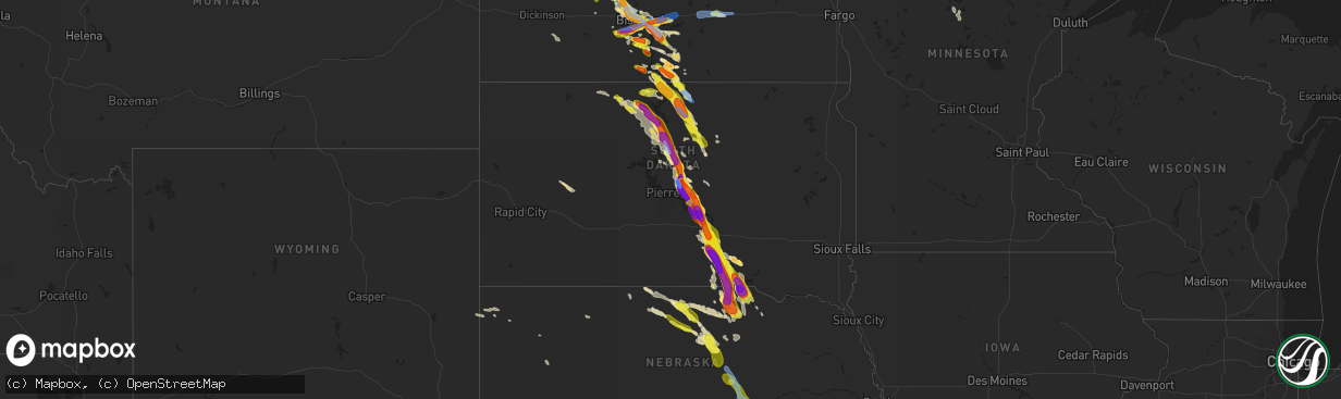
Hail Map in South Dakota on August 6, 2019
The weather event in South Dakota on August 6, 2019 includes Wind and Hail maps. 28 states and 779 cities were impacted and suffered possible damage. The total estimated number of properties impacted is 13,023.
Want more than just the map?
Turn this storm into a full workflow.
- Owner + property data so you know who to knock
- OnDemand branded weather history reports to win the "did we even have hail?" argument
- RoofTrace estimate so reps stop guessing numbers at the door
Bought this map? Upgrade within 7 days and we'll credit the $230. (10-15 min setup call)
Wind
Hail
13,023
Estimated number of impacted properties by a 1.00" hail or larger7,549
Estimated number of impacted properties by a 1.75" hail or larger3,812
Estimated number of impacted properties by a 2.50" hail or largerStorm reports in South Dakota
South Dakota
| Date | Description |
|---|---|
| 08/06/20196:53 PM CDT | A few quarter sized hailstones as well. |
| 08/06/20196:50 PM CDT | A local report indicates 1.75 inch wind near ONIDA |
| 08/06/20196:43 PM CDT | Garden crops damaged and some flattened. |
| 08/06/20196:43 PM CDT | 18 inch diameter tree down on power lines. |
| 08/06/20196:39 PM CDT | All windows on north side of house broken out. |
| 08/06/20196:35 PM CDT | 3 inch diameter branch down. A few quarter size hail... But mostly dime to nickel size. |
| 08/06/20196:25 PM CDT | Winds estimated at at least 80 mph. Hail as large as tennis balls... Although most were smaller. Hail accumulated in drifts that were 7 to 8 inches deep. Wind driven ha |
| 08/06/20196:23 PM CDT | A local report indicates 1.75 inch wind near 1 NNW WHITLOCKS BAY REC |
| 08/06/20196:23 PM CDT | 1.75 inch hail also reported. |
| 08/06/20195:24 PM CDT | 40 mph wind estimate. Corn crop was stripped. |
| 08/06/20195:04 PM CDT | A local report indicates 59 MPH wind near 4 W TRAIL CITY |
| 08/06/20195:00 PM CDT | Depth of hail was 5 inches. Corn crop was stripped. |
| 08/06/20194:45 PM CDT | Ground became white with hail. |
| 08/06/20194:25 PM CDT | Most hailstones between nickel and quarter size. |
| 08/06/20194:00 PM CDT | Brief hail between nickel and quarter size. |
| 08/06/20196:05 AM CDT | At 1104 PM CDT, severe thunderstorms were located along a line extending from Lynch to near Spencer to 8 miles south of Naper, moving south at 40 mph. HAZARD...Golf ball size hail and 70 mph wind gusts. SOURCE...Radar indicated. IMPACT...People and animals outdoors will be injured. Expect hail damage to roofs, siding, windows, and vehicles. Expect considerable tree damage. Wind damage is also likely to mobile homes, roofs, and outbuildings. Severe thunderstorms will be near... Lynch around 1110 PM CDT. Stuart around 1130 PM CDT. Atkinson around 1135 PM CDT. O'Neill and Page around 1145 PM CDT.Other locations impacted by these severe thunderstorms includeBristow, Dustin, Emmet, Scottville, Inman, Redbird State WildlifeManagement Area, Hull Lake State Wildlife Management Area,Opportunity, Spencer Dam and Midway.This includes the following highways... Highway 20 between mile markers 276 and 328. Highway 281 between mile markers 174 and 223. Highway 12 between mile markers 82 and 131. |
| 08/06/20195:46 AM CDT | At 1046 PM CDT, a severe thunderstorm was located over Naper, or 22 miles west of Spencer, moving south at 85 mph. HAZARD...Golf ball size hail and 70 mph wind gusts. SOURCE...Radar indicated. IMPACT...People and animals outdoors will be injured. Expect hail damage to roofs, siding, windows, and vehicles. Expect considerable tree damage. Wind damage is also likely to mobile homes, roofs, and outbuildings. Locations impacted include... Naper, Dustin and Brocksburg. This includes Highway 12 between mile markers 74 and 103. |
| 08/06/20195:33 AM CDT | At 1032 PM CDT, a severe thunderstorm was located near Burke, or 32 miles east of Winner, moving south at 40 mph. This is a very dangerous storm. HAZARD...Baseball size hail and 70 mph wind gusts. SOURCE...Public. IMPACT...People and animals outdoors will be severely injured. Expect shattered windows, extensive damage to roofs, siding, and vehicles. This severe thunderstorm will be near... Herrick around 1045 PM CDT. St. Charles around 1050 PM CDT.Other locations impacted by this severe thunderstorm include Fairfax. |
| 08/06/20195:32 AM CDT | At 1032 PM CDT, a severe thunderstorm was located near Bonesteel, or 13 miles northwest of Spencer, moving southeast at 30 mph. HAZARD...70 mph wind gusts and half dollar size hail. SOURCE...Radar indicated. IMPACT...Hail damage to vehicles is expected. Expect considerable tree damage. Wind damage is also likely to mobile homes, roofs, and outbuildings. This severe thunderstorm will be near... Butte around 1045 PM CDT. Spencer and Gross around 1100 PM CDT. Lynch around 1115 PM CDT.Other locations impacted by this severe thunderstorm include SpencerDam, Bristow, Parshall Bridge State Wildlife Management Area, HullLake State Wildlife Management Area, Anncar and Anoka.This includes the following highways... Highway 281 between mile markers 208 and 223. Highway 12 between mile markers 97 and 131. |
| 08/06/20195:04 AM CDT | At 1003 PM CDT, a severe thunderstorm was located near Iona, or 21 miles south of Chamberlain, moving southeast at 45 mph. HAZARD...Two inch hail and 70 mph wind gusts. SOURCE...Radar indicated. IMPACT...People and animals outdoors will be injured. Expect hail damage to roofs, siding, windows, and vehicles. Expect considerable tree damage. Wind damage is also likely to mobile homes, roofs, and outbuildings. This severe thunderstorm will be near... Burke around 1030 PM CDT. Herrick around 1040 PM CDT.Other locations impacted by this severe thunderstorm include Dixon InGregory County. |
| 08/06/20194:45 AM CDT | At 945 PM CDT, a severe thunderstorm was located near Dude Ranch, or 12 miles west of Chamberlain, moving southeast at 40 mph. HAZARD...Ping pong ball size hail and 60 mph wind gusts. SOURCE...Radar indicated. IMPACT...People and animals outdoors will be injured. Expect hail damage to roofs, siding, windows, and vehicles. Expect wind damage to roofs, siding, and trees. Locations impacted include... Iona and Lake Francis Case. |
| 08/06/20194:44 AM CDT | At 943 PM CDT, a severe thunderstorm was located over Valentine, moving southeast at 45 mph. HAZARD...60 mph wind gusts and quarter size hail. SOURCE...Radar indicated. IMPACT...Hail damage to vehicles is expected. Expect wind damage to roofs, siding, and trees. Locations impacted include... Valentine, Ainsworth, Johnstown, Wood Lake, Antelope Peak and Smith Falls State Park.This includes the following highways... Highway 183 between mile markers 194 and 201. Highway 20 between mile markers 189 and 247. Highway 97 between mile markers 137 and 141. Highway 83 between mile markers 205 and 222. Highway 12 between mile markers 1 and 8. |
| 08/06/20194:38 AM CDT | At 938 PM CDT, a severe thunderstorm was located 15 miles northeast of Burke, or 27 miles south of Kimball, moving southeast at 35 mph. HAZARD...60 mph wind gusts and half dollar size hail. SOURCE...Radar indicated. IMPACT...Hail damage to vehicles is expected. Expect wind damage to roofs, siding, and trees. This severe thunderstorm will be near... Bonesteel around 1015 PM CDT.Other locations impacted by this severe thunderstorm include Fairfax. |
| 08/06/20194:34 AM CDT | At 933 PM CDT, a severe thunderstorm was located near Dude Ranch, or 8 miles west of Chamberlain, moving southeast at 45 mph. HAZARD...Tennis ball size hail and 70 mph wind gusts. SOURCE...Radar indicated. IMPACT...People and animals outdoors will be injured. Expect hail damage to roofs, siding, windows, and vehicles. Expect considerable tree damage. Wind damage is also likely to mobile homes, roofs, and outbuildings. This severe thunderstorm will be near... Chamberlain and Lake Francis Case around 940 PM CDT.Other locations impacted by this severe thunderstorm include Pukwana. |
| 08/06/20193:56 AM CDT | At 856 PM CDT, a severe thunderstorm was located near West Bend Rec Area, or 12 miles north of Lower Brule, moving southeast at 40 mph. HAZARD...Two inch hail and 70 mph wind gusts. SOURCE...Radar indicated. IMPACT...People and animals outdoors will be injured. Expect hail damage to roofs, siding, windows, and vehicles. Expect considerable tree damage. Wind damage is also likely to mobile homes, roofs, and outbuildings. Locations impacted include... Lower Brule, Fort Thompson, Oacoma, Shelby, Crow Creek Housing, Tailrace Rec Area, Joe Creek Rec Area, Medicine Butte, Counselor Creek Boat Access Area, Stephan, Dude Ranch, Etbauer Hill, Lake Sharpe, Lees Corner, West Bend Rec Area and Lake Francis Case. |
| 08/06/20193:52 AM CDT | At 852 PM CDT, a severe thunderstorm was located near Lake Francis Case, or 7 miles south of Chamberlain, moving southeast at 45 mph. HAZARD...70 mph wind gusts and ping pong ball size hail. SOURCE...Radar indicated. IMPACT...People and animals outdoors will be injured. Expect hail damage to roofs, siding, windows, and vehicles. Expect considerable tree damage. Wind damage is also likely to mobile homes, roofs, and outbuildings. This severe thunderstorm will remain over mainly rural areas of northwestern Charles Mix, northwestern Gregory and Brule Counties, including the following locations... Pukwana. |
| 08/06/20193:40 AM CDT | At 840 PM CDT, a severe thunderstorm was located near Dude Ranch, or 7 miles west of Chamberlain, moving southeast at 35 mph. HAZARD...70 mph wind gusts and ping pong ball size hail. SOURCE...Radar indicated. IMPACT...People and animals outdoors will be injured. Expect hail damage to roofs, siding, windows, and vehicles. Expect considerable tree damage. Wind damage is also likely to mobile homes, roofs, and outbuildings. Locations impacted include... Oacoma, Iona, Dude Ranch and Lake Francis Case. |
| 08/06/20193:22 AM CDT | At 822 PM CDT, a severe thunderstorm was located near Blunt, or 16 miles southeast of Onida, moving southeast at 40 mph. HAZARD...Golf ball size hail and 70 mph wind gusts. SOURCE...Trained weather spotters. At 820 pm, golf ball sized hail was reported one mile east of Blunt. IMPACT...People and animals outdoors will be injured. Expect hail damage to roofs, siding, windows, and vehicles. Expect considerable tree damage. Wind damage is also likely to mobile homes, roofs, and outbuildings. Locations impacted include... Blunt, Harrold, Stephan, West Bend Rec Area and Lake Sharpe. |
| 08/06/20193:15 AM CDT | At 813 PM CDT, a severe thunderstorm was located over Reliance, or 12 miles south of Lower Brule, moving southeast at 45 mph. HAZARD...70 mph wind gusts and half dollar size hail. SOURCE...Trained weather spotters. IMPACT...Hail damage to vehicles is expected. Expect considerable tree damage. Wind damage is also likely to mobile homes, roofs, and outbuildings. This severe thunderstorm will be near... Lake Francis Case around 825 PM CDT. |
| 08/06/20192:59 AM CDT | At 759 PM CDT, a severe thunderstorm was located over Tolstoy, or 19 miles northeast of Gettysburg, moving southeast at 45 mph. HAZARD...60 mph wind gusts and half dollar size hail. SOURCE...Radar indicated. IMPACT...Hail damage to vehicles is expected. Expect wind damage to roofs, siding, and trees. Locations impacted include... Hoven, Seneca, Tolstoy, Onaka and Burkmere. |
| 08/06/20192:46 AM CDT | At 745 PM CDT, a severe thunderstorm was located near Lake Sharpe, or 15 miles northwest of Lower Brule, moving southeast at 45 mph. This is a very dangerous storm. HAZARD...80 mph wind gusts and ping pong ball size hail. SOURCE...Radar indicated. IMPACT...Flying debris will be dangerous to those caught without shelter. Mobile homes will be heavily damaged. Expect considerable damage to roofs, windows, and vehicles. Extensive tree damage and power outages are likely. Locations impacted include... Lower Brule, Lyman, Oacoma, Reliance, Joe Creek Rec Area, Medicine Butte, Counselor Creek Boat Access Area, Dude Ranch, Lake Sharpe, Degrey Rec Area, West Bend Rec Area, Cedar Creek Rec Area and Lake Francis Case. |
| 08/06/20192:22 AM CDT | At 721 PM CDT, a severe thunderstorm was located over Selby, moving southeast at 40 mph. HAZARD...60 mph wind gusts and quarter size hail. SOURCE...Trained weather spotters. IMPACT...Hail damage to vehicles is expected. Expect wind damage to roofs, siding, and trees. Locations impacted include... Selby, Hoven, Java, Lebanon, Tolstoy, Lowry and Lake Hiddenwood Rec Area. |
| 08/06/20191:58 AM CDT | At 658 PM CDT, a severe thunderstorm was located over Mound City, or 14 miles north of Selby, moving southeast at 35 mph. HAZARD...60 mph wind gusts and quarter size hail. SOURCE...Radar indicated. IMPACT...Hail damage to vehicles is expected. Expect wind damage to roofs, siding, and trees. Locations impacted include... Java, Mound City and Lake Hiddenwood Rec Area. |
| 08/06/20191:52 AM CDT | At 652 PM CDT, a severe thunderstorm was located 9 miles southwest of Eureka, moving southeast at 35 mph. HAZARD...60 mph wind gusts and half dollar size hail. SOURCE...Radar indicated. IMPACT...Hail damage to vehicles is expected. Expect wind damage to roofs, siding, and trees. Locations impacted include... Hosmer and Hillsview. |
| 08/06/20191:51 AM CDT | At 651 PM CDT, a severe thunderstorm was located near Onida, moving southeast at 45 mph. This is a very dangerous storm. HAZARD...80 mph wind gusts and two inch hail. SOURCE...Radar indicated. IMPACT...Flying debris will be dangerous to those caught without shelter. Mobile homes will be heavily damaged. Expect considerable damage to roofs, windows, and vehicles. Extensive tree damage and power outages are likely. Locations impacted include... Onida, Blunt, Harrold, Agar, Lake Sharpe, Canning, Degrey Rec Area, Sully Lake and Cottonwood Lake Near Agar. |
| 08/06/20191:01 AM CDT | At 600 PM CDT, a severe thunderstorm was located near Westfield, or 21 miles south of Linton, moving southeast at 25 mph. HAZARD...Two inch hail and 70 mph wind gusts. SOURCE...Radar indicated. IMPACT...People and animals outdoors will be injured. Expect hail damage to roofs, siding, windows, and vehicles. Expect considerable tree damage. Wind damage is also likely to mobile homes, roofs, and outbuildings. Locations impacted include... Herreid, Mound City and Artas. |
| 08/06/201912:56 AM CDT | At 556 PM CDT/456 PM MDT/, a severe thunderstorm was located near Swiftbird Day School, or 24 miles northwest of Gettysburg, moving southeast at 35 mph. HAZARD...70 mph wind gusts and ping pong ball size hail. SOURCE...Radar indicated. IMPACT...People and animals outdoors will be injured. Expect hail damage to roofs, siding, windows, and vehicles. Expect considerable tree damage. Wind damage is also likely to mobile homes, roofs, and outbuildings. Locations impacted include... Gettysburg, Onida, Agar, Lebanon, Swiftbird, Cottonwood Lake Near Agar, Whitlocks Bay Rec Area, Gorman, Laplant, Blackfoot, Tiospaye Topa School, Swiftbird Day School, Lake Oahe, Sutton Bay Rec Area and Sully Lake. |
| 08/06/201912:24 AM CDT | At 524 PM CDT/424 PM MDT/, a severe thunderstorm was located near Trail City, or 10 miles southwest of Mobridge, moving east at 25 mph. This is a very dangerous storm. HAZARD...Baseball size hail and 70 mph wind gusts. SOURCE...Radar indicated. IMPACT...People and animals outdoors will be severely injured. Expect shattered windows, extensive damage to roofs, siding, and vehicles. Locations impacted include... Mobridge, Glenham, New Everets Resort, Revheim Bay Rec Area, Indian Creek Rec Area and Blackfoot. |
| 08/05/201911:10 PM CDT | At 410 PM MDT, a severe thunderstorm was located over Spring Lake, or 22 miles south of Mclaughlin, moving southeast at 35 mph. HAZARD...Golf ball size hail and 70 mph wind gusts. SOURCE...Radar indicated. IMPACT...People and animals outdoors will be injured. Expect hail damage to roofs, siding, windows, and vehicles. Expect considerable tree damage. Wind damage is also likely to mobile homes, roofs, and outbuildings. Locations impacted include... Tiospaye Topa School, Promise, Spring Lake, Trail City, Laplant, Glencross and Lake Oahe. |
| 08/05/201910:35 PM CDT | At 335 PM MDT, a severe thunderstorm was located near Klein Ranch, or 21 miles southwest of Mclaughlin, moving east at 30 mph. HAZARD...Ping pong ball size hail and 60 mph wind gusts. SOURCE...Radar indicated. IMPACT...People and animals outdoors will be injured. Expect hail damage to roofs, siding, windows, and vehicles. Expect wind damage to roofs, siding, and trees. Locations impacted include... Spring Lake, Bullhead and Little Eagle. |
| 08/05/201910:30 PM CDT | At least six large pine... Spruce... And cedar trees down in yard. |
| 08/05/201910:30 PM CDT | Very strong wind gust has caused tree branches to come down... And burke lost power for a couple minutes. |
| 08/05/201910:30 PM CDT | Building debris scattered across the highway. |
| 08/05/201910:25 PM CDT | *** 2 inj *** widespread 80 to 100 mph winds were reported across burke. An ef-1 tornado touched down in burke with path width of 75 yards and path length of 3.8 miles. |
| 08/05/201910:23 PM CDT | At 322 PM MDT, a severe thunderstorm was located near Spring Lake, or 16 miles south of Mclaughlin, moving east at 20 mph. HAZARD...60 mph wind gusts and half dollar size hail. SOURCE...Radar indicated. IMPACT...Hail damage to vehicles is expected. Expect wind damage to roofs, siding, and trees. Locations impacted include... Promise, Spring Lake, Trail City, Mahto and Little Eagle. |
| 08/05/201910:10 PM CDT | Hail destroyed windshield and headlights. No injuries. Report relayed via spotter who came across the disabled vehicle and occupants. |
| 08/05/201910:04 PM CDT | Hail size is unknown... But it was large enough to damage siding... Break windows... And severely damage crops. Radar estimated time. |
| 08/05/20199:57 PM CDT | Trees down... Shingles off homeowners roof. Radar estimated time. |
| 08/05/20199:54 PM CDT | Nickel up to golf ball sized hail fell. |
| 08/05/20199:47 PM CDT | At 246 PM MDT, a severe thunderstorm was located 10 miles southwest of Watauga, or 27 miles southeast of Lemmon, moving east at 25 mph. HAZARD...60 mph wind gusts and half dollar size hail. SOURCE...Radar indicated. IMPACT...Hail damage to vehicles is expected. Expect wind damage to roofs, siding, and trees. Locations impacted include... Klein Ranch and Black Horse. |
| 08/05/20199:28 PM CDT | A local report indicates 1.00 inch wind near 18 S PUKWANA |
| 08/05/20199:15 PM CDT | A local report indicates 60 MPH wind near LOWER BRULE |
| 08/05/20199:15 PM CDT | A local report indicates 2.00 inch wind near 6 SSW PLATTE |
| 08/05/20199:15 PM CDT | Tennis ball to baseball size hail. Window damage to vehicles and homes. |
| 08/05/20199:15 PM CDT | A local report indicates 2.00 inch wind near 6 SSW CHAMBERLAIN |
| 08/05/20199:05 PM CDT | A local report indicates 1.00 inch wind near 4 NW WEST BEND REC AREA |
| 08/05/20199:00 PM CDT | Hail stones have been increasing in size over the past 5 minutes. |
| 08/05/20198:57 PM CDT | Hail stones have been increasing in size over the past 5 minutes. |
| 08/05/20198:57 PM CDT | A local report indicates 1.00 inch wind near 8 SSW CHAMBERLAIN |
| 08/05/20198:45 PM CDT | Dot rwis. |
| 08/05/20198:28 PM CDT | Quarter to half dollar size. No apparent damage noticeable. |
| 08/05/20198:20 PM CDT | A local report indicates 1.75 inch wind near 1 E BLUNT |
| 08/05/20198:10 PM CDT | A local report indicates 1.00 inch wind near 3 ESE TOLSTOY |
| 08/05/20198:05 PM CDT | Mostly golf ball size hail with a few baseball size. |
| 08/05/20197:50 PM CDT | Mostly quarter size hail... Some half dollar size. Some garden crop damage. |
| 08/05/20197:48 PM CDT | Many hail stones exceeding 3 inches in size. |
| 08/05/20197:47 PM CDT | A local report indicates 1.00 inch wind near 2 N HOVEN |
| 08/05/20197:40 PM CDT | Time estimated from radar. |
| 08/05/20197:33 PM CDT | A local report indicates 60 MPH wind near 2 S JAVA |
| 08/05/20197:30 PM CDT | Mostly golf ball size hail. Vehicle windows shattered. |
| 08/05/20197:28 PM CDT | Mostly dime to nickel size hail with some quarter size. |
| 08/05/20197:21 PM CDT | Golf ball to baseball sized hail fell from 1 mile west to 1 mile east of blunt. Several reports of windows and siding broken. Tree limbs down. Winds estimated 60 to 65 |
| 08/05/20197:20 PM CDT | Also measured 2.4 inch hail 20 minutes after it fell. |
| 08/05/20197:18 PM CDT | Over 60 mph estimated as well. |
All States Impacted by Hail Map on August 6, 2019
Cities Impacted by Hail Map on August 6, 2019
- Burlington, CO
- Herreid, SD
- Grand Forks, ND
- Gilby, ND
- Inkster, ND
- Manvel, ND
- Fordville, ND
- Forest River, ND
- Minto, ND
- Mekinock, ND
- Campbellsburg, IN
- Orleans, IN
- Corydon, KY
- Henderson, KY
- Cannon Ball, ND
- Newark Valley, NY
- Berkshire, NY
- Scott City, MO
- Harrison, NE
- Macedonia, IL
- Springerton, IL
- McLeansboro, IL
- Enfield, IL
- Dahlgren, IL
- Zap, ND
- Golden Valley, ND
- Hazen, ND
- Dodge, ND
- Halliday, ND
- Beulah, ND
- Dyersburg, TN
- Friendship, TN
- Minneola, KS
- Perryton, TX
- Bismarck, ND
- Stanton, ND
- Harrold, SD
- Pierre, SD
- Johnstown, NE
- Ainsworth, NE
- Long Pine, NE
- Burrton, KS
- Moundridge, KS
- Benton, KY
- Gilbertsville, KY
- Rinard, IL
- Xenia, IL
- Johnsonville, IL
- Madison, TN
- Hendersonville, TN
- Goodlettsville, TN
- Old Hickory, TN
- Greenbrier, TN
- Raleigh, IL
- Eldorado, IL
- Galatia, IL
- Broughton, IL
- Blunt, SD
- Lesterville, MO
- Centerville, MO
- Redford, MO
- Burke, SD
- Gregory, SD
- Whitewater, MO
- Chaffee, MO
- Cape Girardeau, MO
- Stonefort, IL
- Golconda, IL
- Eddyville, IL
- Herod, IL
- Jackson, MO
- Stuart, NE
- Atkinson, NE
- Naper, NE
- Halstead, KS
- Sedgwick, KS
- Hornsby, TN
- Wood Lake, NE
- Selby, SD
- Java, SD
- Holabird, SD
- Gettysburg, SD
- Onida, SD
- Eagle Butte, SD
- Trail City, SD
- Lower Brule, SD
- Wakpala, SD
- Agar, SD
- Fort Thompson, SD
- Goodridge, MN
- Grygla, MN
- Silex, MO
- Ellington, MO
- Austin, KY
- Fountain Run, KY
- Lexington, IN
- Nabb, IN
- Princeton, KY
- Sikeston, MO
- Benton, MO
- Oran, MO
- Dresden, TN
- Bassett, NE
- Burwell, NE
- Hurdsfield, ND
- Harvey, ND
- Laporte, MN
- Bemidji, MN
- Mandan, ND
- Center, ND
- New Salem, ND
- Pen Argyl, PA
- Belvidere, NJ
- Nazareth, PA
- Phillipsburg, NJ
- Bangor, PA
- Newton, KS
- Ojo Caliente, NM
- Hartford, KY
- Solen, ND
- Dawson Springs, KY
- Marion, KY
- Fredonia, KY
- Pittsburg, KS
- Girard, KS
- Cherokee, KS
- Gate, OK
- Charlotte, TN
- White Bluff, TN
- Englewood, KS
- Deposit, NY
- Hancock, NY
- Bethlehem, IN
- New Washington, IN
- Bowdle, SD
- Oberon, ND
- Backus, MN
- Pine River, MN
- Hackensack, MN
- Hillsboro, MO
- De Soto, MO
- Southside, TN
- Labadie, MO
- Laverne, OK
- Rosston, OK
- Ironton, MO
- Grand Rivers, KY
- Smithland, KY
- Nunnelly, TN
- Fairfield, IL
- New Madrid, MO
- Matthews, MO
- Bertrand, MO
- East Prairie, MO
- Mercer, TN
- Denmark, TN
- Jackson, TN
- Martinsville, IL
- Saint Albans, MO
- Villa Ridge, MO
- Dittmer, MO
- Washington, MO
- Marthasville, MO
- Robertsville, MO
- Defiance, MO
- Foristell, MO
- Saint Clair, MO
- Augusta, MO
- Lonedell, MO
- Catawissa, MO
- Gray Summit, MO
- Pacific, MO
- House Springs, MO
- Eureka, MO
- Union, MO
- Cedar Hill, MO
- Bunker, MO
- Geddes, SD
- Platte, SD
- Salem, IL
- Iuka, IL
- Patoka, IL
- Odin, IL
- Sandoval, IL
- Annapolis, MO
- Caledonia, MO
- Arcadia, MO
- Belgrade, MO
- Belleview, MO
- Middle Brook, MO
- Yuma, CO
- Sturgis, KY
- Potwin, KS
- Whitewater, KS
- Bethune, CO
- Goodrich, ND
- Alexandria, KY
- Latonia, KY
- Newport, KY
- Ft Mitchell, KY
- Independence, KY
- Jonesboro, AR
- Beech Grove, AR
- Peach Orchard, AR
- Paragould, AR
- Walnut Ridge, AR
- Delaplaine, AR
- Bono, AR
- Pocahontas, AR
- Dixon, KY
- Nebo, KY
- Slaughters, KY
- Manitou, KY
- Cleveland, ND
- Medina, ND
- Port Saint Lucie, FL
- Strasburg, ND
- Saint Paul, KS
- Wayne City, IL
- Sims, IL
- Potosi, MO
- Junction City, AR
- Newport, NE
- Linton, ND
- Highmore, SD
- Leasburg, MO
- Steelville, MO
- Nashville, TN
- Bells, TN
- Niagara, ND
- Petersburg, ND
- Crookston, NE
- Valentine, NE
- Underwood, ND
- Vandalia, IL
- Ramsey, IL
- Mulberry Grove, IL
- Shobonier, IL
- Seneca, SD
- Walnut, KS
- Erie, KS
- Booker, TX
- Pollock, SD
- Hague, ND
- Dickson, TN
- Bon Aqua, TN
- McEwen, TN
- Morganfield, KY
- Adairville, KY
- Adams, TN
- Cedar Hill, TN
- Olmstead, KY
- Springfield, TN
- Humansville, MO
- Stockton, MO
- Uniontown, KS
- Redfield, KS
- Bronson, KS
- Medon, TN
- Brownsville, TN
- Queenstown, MD
- Saint Michaels, MD
- Claiborne, MD
- Millville, DE
- Frankford, DE
- Ocean View, DE
- Watauga, SD
- Toone, TN
- Howes, SD
- White Owl, SD
- Wall, SD
- Sterling, ND
- Great Falls, VA
- Beaver Dam, KY
- Centertown, KY
- Castle Creek, NY
- Chenango Forks, NY
- Greene, NY
- Trezevant, TN
- Greenfield, TN
- McKenzie, TN
- Conneaut, OH
- Follett, TX
- Higgins, TX
- Lipscomb, TX
- Henderson, TN
- Finger, TN
- Bridgeport, IL
- Sumner, IL
- Baltimore, MD
- Kit Carson, CO
- Cadiz, KY
- Eureka, SD
- Saint Francisville, IL
- Allendale, IL
- Idalia, CO
- Kirk, CO
- Carmi, IL
- Mound City, SD
- Hornbeak, TN
- Burna, KY
- Salem, KY
- Gadsden, TN
- Poplar Bluff, MO
- Grandin, MO
- Dahlen, ND
- Denhoff, ND
- Bethesda, MD
- Washington, DC
- Chevy Chase, MD
- Corinth, MS
- Barnhill, IL
- Flora, IL
- Geff, IL
- Mill Shoals, IL
- Norris City, IL
- Keenes, IL
- Cisne, IL
- Bluford, IL
- Fort Plain, NY
- Little Falls, NY
- Cresco, PA
- Canadensis, PA
- Alton, MO
- Couch, MO
- Brentwood, TN
- Thief River Falls, MN
- Newfolden, MN
- Herrick, SD
- Mills, NE
- Naylor, MO
- Doniphan, MO
- Oxly, MO
- Moffit, ND
- Braddock, ND
- Flasher, ND
- Hazelton, ND
- Menoken, ND
- Saint Anthony, ND
- Troy, KS
- Denton, KS
- Montgomery, IN
- El Dorado Springs, MO
- Collins, MO
- Bethel Springs, TN
- Hoven, SD
- Tolstoy, SD
- Yale, IL
- Newton, IL
- Willow Hill, IL
- Wheeler, IL
- Collinwood, TN
- Waynesboro, TN
- Cassoday, KS
- Burns, KS
- Dale, IL
- Thompsonville, IL
- Harrisburg, IL
- Cadet, MO
- Mineral Point, MO
- Davisville, MO
- McLaughlin, SD
- Saint Charles, SD
- Fairfax, SD
- Pukwana, SD
- Reliance, SD
- Bonesteel, SD
- Oacoma, SD
- Chamberlain, SD
- Cynthiana, KY
- Paris, KY
- Carlisle, KY
- Eddyville, KY
- Oxford, AR
- Brockwell, AR
- Wideman, AR
- Violet Hill, AR
- Boss, MO
- Brownsville, KY
- Smiths Grove, KY
- Bowling Green, KY
- Robards, KY
- Regent, ND
- Hepler, KS
- Fort Scott, KS
- Moran, KS
- Cass Lake, MN
- Junction, IL
- Equality, IL
- Rochester, KY
- Fort Yates, ND
- Hoyt, KS
- Meriden, KS
- Falkner, MS
- Tiplersville, MS
- Butte, NE
- Sullivan, MO
- Carson, NM
- Mcclusky, ND
- Spencer, NE
- Eads, CO
- Charlestown, IN
- Otisco, IN
- Hanover, IN
- Marysville, IN
- Henryville, IN
- Westport, KY
- Underwood, IN
- Bedford, KY
- Cottontown, TN
- Whites Creek, TN
- White House, TN
- Joelton, TN
- Roseau, MN
- Salem, MO
- Centerville, TN
- Lyles, TN
- Kanorado, KS
- Mount Carmel, IL
- Huron, TN
- Cerrillos, NM
- Faulkton, SD
- Michigan, ND
- Larimore, ND
- Mountain Dale, NY
- Fairview, TN
- Byron, NE
- Blackwell, MO
- Ash Grove, MO
- Aldrich, MO
- Walnut Grove, MO
- Eckley, CO
- Park City, KY
- Cave City, KY
- Texico, IL
- Beltsville, MD
- Livermore, KY
- Primm Springs, TN
- Franklin, TN
- Ridgely, TN
- Obion, TN
- Tiptonville, TN
- Troy, TN
- Glasgow, KY
- Cedarville, OH
- Leonardville, KS
- Randolph, KS
- Versailles, IN
- Lamar, CO
- Holly, CO
- Alta Vista, KS
- Alma, KS
- Bolivar, TN
- Marsland, NE
- Conway Springs, KS
- Viola, KS
- Glencross, SD
- Hamill, SD
- Bristow, NE
- Oneill, NE
- Lynch, NE
- Kennebec, SD
- Timber Lake, SD
- Fort Campbell, KY
- Woodlawn, TN
- Indian Mound, TN
- Cumberland City, TN
- La Fayette, KY
- Big Rock, TN
- Palmyra, TN
- Ashland City, TN
- Kunkletown, PA
- Wright City, MO
- Solway, MN
- Eminence, KY
- Shelbyville, KY
- Dillsboro, IN
- Ruskin, NE
- Richwoods, MO
- Andale, KS
- Vernon, CO
- Goddard, KS
- Corning, AR
- Glenham, SD
- Everton, MO
- Torrington, WY
- Knobel, AR
- Lafayette Hill, PA
- Narberth, PA
- Philadelphia, PA
- Clarksville, TN
- Philip, SD
- Enning, SD
- Bagley, MN
- El Dorado, AR
- White Oak, GA
- Sheridan Lake, CO
- Lakota, ND
- Central City, KY
- McHenry, KY
- La Vergne, TN
- Antioch, TN
- Nolensville, TN
- Michie, TN
- Ramer, TN
- Guys, TN
- Selmer, TN
- State University, AR
- Shawnee, WY
- Holton, IN
- Osgood, IN
- Bourbon, MO
- Pilot Knob, MO
- Russellville, KY
- Dover, TN
- Tennessee Ridge, TN
- Huntingdon, TN
- Stratton, CO
- Arapahoe, CO
- Rising City, NE
- Oblong, IL
- Alliance, NE
- Ewing, IL
- Whittington, IL
- Benton, IL
- Welch, OK
- Bluejacket, OK
- Miami, OK
- Goodland, KS
- Harviell, MO
- Chambers, NE
- Effingham, IL
- Teutopolis, IL
- Westport, IN
- Greensburg, IN
- O'Fallon, MO
- Lake Saint Louis, MO
- Wentzville, MO
- Success, AR
- Gatzke, MN
- Lawrenceville, IL
- Salem, IN
- Burnsville, MS
- Glen, MS
- Garden Plain, KS
- Easton, MD
- Scammon, KS
- Carlyle, IL
- Shawneetown, IL
- Burnt Prairie, IL
- Clay, KY
- Cave In Rock, IL
- Alma, IL
- Elizabethtown, IL
- Omaha, IL
- Kinmundy, IL
- Ridgway, IL
- Belle Rive, IL
- West Frankfort, IL
- Nortonville, KY
- White Plains, KY
- Cathay, ND
- New Rockford, ND
- Reynolds Station, KY
- Fordsville, KY
- Chapmansboro, TN
- Stark, KS
- Wildersville, TN
- Gettysburg, PA
- Altamont, IL
- Fessenden, ND
- Atwood, TN
- Cedar Grove, TN
- Madisonville, KY
- Providence, KY
- Hanson, KY
- Stewart, TN
- Kintyre, ND
- Driscoll, ND
- Merriman, NE
- Beechmont, KY
- Drakesboro, KY
- Beech Creek, KY
- Belton, KY
- Browder, KY
- Humboldt, TN
- Trenton, TN
- Middleton, TN
- Walnut, MS
- Pocahontas, TN
- Amarillo, TX
- Cottage Grove, TN
- Dukedom, TN
- Palmersville, TN
- Havre, MT
- Bala Cynwyd, PA
- Glenside, PA
- Flourtown, PA
- Conshohocken, PA
- Gladwyne, PA
- Lake George, MN
- Dodge City, KS
- Sheyenne, ND
- Erin, TN
- Holladay, TN
- Westport, TN
- Lawrenceburg, TN
- Marion, IL
- Puryear, TN
- Shumway, IL
- Decker, IN
- Vincennes, IN
- Paris, TN
- Berry, KY
- Enville, TN
- Cherryville, MO
- Viburnum, MO
- Pinson, TN
- Amelia, NE
- Evansville, IN
- Patoka, IN
- Owensville, IN
- Charleston, MO
- Smithfield, KY
- Lucas, KY
- Chanute, KS
- Mount Olivet, KY
- Montrose, IL
- Kuttawa, KY
- Mound City, IL
- Mounds, IL
- Cincinnati, OH
- Dexter, MO
- Dudley, MO
- Union City, TN
- Portageville, MO
- Elbing, KS
- Scottsville, KY
- Alamo, TN
- Halls, TN
- Columbus, KS
- Bone Gap, IL
- Hopkinsville, KY
- Crofton, KY
- Newbern, TN
- Potomac, MD
- Bridgeport, NE
- Wind Gap, PA
- Caneyville, KY
- McLean, VA
- Cabin John, MD
- Glen Echo, MD
- Hillsboro, KY
- Owingsville, KY
- Holland, KY
- Bumpus Mills, TN
- Burfordville, MO
- Mount Vernon, IN
- Uniontown, KY
- Savannah, NY
- McIntosh, SD
- McCune, KS
- Essex, MO
- Bloomfield, MO
- Watson, IL
- Dieterich, IL
- Warrenton, MO
- Saint Cloud, FL
- Robinson, KS
- Hiawatha, KS
- Morgantown, KY
- Buena Vista, TN
- Lisle, NY
- Metropolis, IL
- Grantsburg, IL
- Vienna, IL
- Simpson, IL
- Glen Ullin, ND
- Carrier Mills, IL
- Green, KS
- Greenleaf, KS
- Barnes, KS
- Dundas, IL
- Burlingame, KS
- Mchenry, ND
- Kilgore, NE
- Weir, KS
- Farlington, KS
- Calhoun, KY
- Cub Run, KY
- Mammoth Cave, KY
- Mohawk, NY
- Beech Bluff, TN
- Luray, TN
- Troy, MO
- Moscow Mills, MO
- Jay Em, WY
- Miller City, IL
- Marble Hill, MO
- Thebes, IL
- Hickman, KY
- Westmoreland, KS
- Cumberland Furnace, TN
- Vanleer, TN
- Etoile, KY
- Rosiclare, IL
- Selbyville, DE
- Dagsboro, DE
- Boelus, NE
- Saint Paul, NE
- Clay Center, NE
- Cairo, NE
- Superior, NE
- Chapman, NE
- Elba, NE
- Shelton, NE
- Alda, NE
- Oak, NE
- Glenvil, NE
- Ord, NE
- Ayr, NE
- Dannebrog, NE
- Harvard, NE
- North Loup, NE
- Saint Libory, NE
- Loup City, NE
- Nelson, NE
- Webber, KS
- Elyria, NE
- Aurora, NE
- Wood River, NE
- Republic, KS
- Grand Island, NE
- Palmer, NE
- Phillips, NE
- Ashton, NE
- Blue Hill, NE
- Farwell, NE
- Giltner, NE
- Inland, NE
- Edgar, NE
- Deweese, NE
- Doniphan, NE
- Trumbull, NE
- Marquette, NE
- Juniata, NE
- Hastings, NE
- Fairfield, NE
- Hardy, NE
- Onaka, SD
- Meade, KS
- Scotia, NE
- Tappen, ND
- Jamestown, ND
- Black, MO
- Milton, KS
- Cheney, KS
- Riley, KS
- Manhattan, KS
- Wamego, KS
- Saint George, KS
- Olsburg, KS
- Emmett, KS
- Paxico, KS
- Onaga, KS
- Eskridge, KS
- Belvue, KS
- Saint Marys, KS
- McFarland, KS
- Melvern, KS
- Quenemo, KS
- Vassar, KS
- Lyndon, KS
- Lebo, KS
- Osage City, KS
- Scranton, KS
- Allen, KS
- Dundalk, MD
- Rosedale, MD


