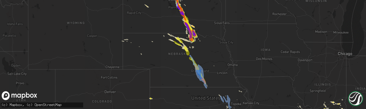
Hail Map in Nebraska on August 6, 2019
The weather event in Nebraska on August 6, 2019 includes Wind and Hail maps. 28 states and 779 cities were impacted and suffered possible damage. The total estimated number of properties impacted is 19,756.
Want more than just the map?
Turn this storm into a full workflow.
- Owner + property data so you know who to knock
- OnDemand branded weather history reports to win the "did we even have hail?" argument
- RoofTrace estimate so reps stop guessing numbers at the door
Bought this map? Upgrade within 7 days and we'll credit the $230. (10-15 min setup call)
Wind
Hail
19,756
Estimated number of impacted properties by a 1.00" hail or larger7,281
Estimated number of impacted properties by a 1.75" hail or larger1,995
Estimated number of impacted properties by a 2.50" hail or largerStorm reports in Nebraska
Nebraska
| Date | Description |
|---|---|
| 08/06/20196:45 AM CDT | At 1145 PM CDT, severe thunderstorms were located along a line extending from 6 miles northeast of O'Neill to 6 miles east of Atkinson to near Stuart, moving southeast at 40 mph. HAZARD...60 mph wind gusts and quarter size hail. SOURCE...Radar indicated. IMPACT...Hail damage to vehicles is expected. Expect wind damage to roofs, siding, and trees. Severe thunderstorms will be near... O'Neill around 1200 AM CDT. Page around 1205 AM CDT. Amelia around 1215 AM CDT. Chambers around 1225 AM CDT.Other locations impacted by these severe thunderstorms include Inmanand Emmet.This includes the following highways... Highway 20 between mile markers 277 and 324. Highway 281 between mile markers 165 and 195. |
| 08/06/20193:58 AM CDT | Delayed report of 6-8 inch branches broken in hardy. Time estimated from radar. |
| 08/06/20193:45 AM CDT | Social media report of widespread tree damage in oak. Time estimated from radar. |
| 08/06/20193:43 AM CDT | A local report indicates 73 MPH wind near 1 N NELSON |
| 08/06/20193:41 AM CDT | A local report indicates 71 MPH wind near 1 N NELSON |
| 08/06/20193:41 AM CDT | A local report indicates 63 MPH wind near 5 N NELSON |
| 08/06/20193:38 AM CDT | A local report indicates 67 MPH wind near 3 W EDGAR |
| 08/06/20193:27 AM CDT | Social media report of widespread tree damage in fairfield. Time estimated from radar and nearby mesonet sites. |
| 08/06/20193:25 AM CDT | A local report indicates 85 MPH wind near 2 WNW FAIRFIELD |
| 08/06/20193:25 AM CDT | A local report indicates 70 MPH wind near 2 NNE DEWEESE |
| 08/06/20193:20 AM CDT | Delayed report. Damage to 9 pivots and extensive crop damage on usmarc campus. Several buildings also damaged... Ranging from broken windows to partial removal of roofs |
| 08/06/20193:12 AM CDT | Delayed report. 27 railway cars flipped on their sides. Time estimated from radar and other nearby reports. |
| 08/06/20193:10 AM CDT | A local report indicates 70 MPH wind near HASTINGS AIRPORT |
| 08/06/20193:10 AM CDT | A local report indicates 65 MPH wind near 2 SW ROSELAND |
| 08/06/20193:10 AM CDT | Buildings were damaged in the glenvil and fairfield areas. Estimated 80 mph winds. Numerous trees and power lines down. The coop in fairfield had an entire wall blown o |
| 08/06/20193:10 AM CDT | Trailer home was flipped onto side. It was not strapped down. Time estimated from radar. |
| 08/06/20193:09 AM CDT | A local report indicates 60 MPH wind near 3 NW INLAND |
| 08/06/20193:05 AM CDT | Delayed report. Large trees uprooted on the central community college campus. Time estimated from radar. |
| 08/06/20193:02 AM CDT | Peak gust from davis station at nws hastings. |
| 08/06/20193:01 AM CDT | A local report indicates 79 MPH wind near 1 ESE DONIPHAN |
| 08/06/20193:00 AM CDT | A local report indicates 67 MPH wind near 2 S DONIPHAN |
| 08/06/20193:00 AM CDT | Large tree snapped at ground level and thrown 10 to 15 feet. Also foundation damage to a small outbuilding. Time estimated from radar. Picture via twitter. |
| 08/06/20192:59 AM CDT | A local report indicates 76 MPH wind near 5 SSE GRAND ISLAND |
| 08/06/20192:57 AM CDT | A local report indicates 64 MPH wind near 6 WNW HANSEN |
| 08/06/20192:55 AM CDT | Large tree trunk snapped just above the ground. Picture via facebook. Time estimated from radar. |
| 08/06/20192:54 AM CDT | A local report indicates 75 MPH wind near 1 ESE DONIPHAN |
| 08/06/20192:51 AM CDT | A local report indicates 87 MPH wind near GRAND ISLAND AIRPORT |
| 08/06/20192:50 AM CDT | Video and pictures of extensive tree damage at stuhr museum. Trees uprooted and large limbs broken. Time estimated from radar. |
| 08/06/20192:50 AM CDT | Widespread tree damage and power outages in and around the grand island area. Roof and shed damage also reported. Very heavy rainfall resulted in flooding of city stree |
| 08/06/20192:49 AM CDT | A local report indicates 75 MPH wind near GRAND ISLAND AIRPORT |
| 08/06/20192:46 AM CDT | A local report indicates 66 MPH wind near 3 NE ALDA |
| 08/06/20192:45 AM CDT | 150 year old black walnut tree fell on 2 vehicles. Also caused roof damage to home. Extensive damage to corn. Large hackberry tree snapped in half. Power lines down. Ti |
| 08/06/20192:44 AM CDT | A local report indicates 71 MPH wind near 2 N ALDA |
| 08/06/20192:43 AM CDT | Corrects previous non-tstm wnd dmg report from 3 nw alda to tstm wnd dmg. Delayed report. Significant damage to large metal building. Picture via social media. |
| 08/06/20192:42 AM CDT | A local report indicates 80 MPH wind near 3 WNW ALDA |
| 08/06/20192:40 AM CDT | Several trees downed. Flower beds uprooted. Delayed report...time estimated from radar. |
| 08/06/20192:33 AM CDT | A local report indicates 69 MPH wind near 1 S CAIRO |
| 08/06/20192:30 AM CDT | Also had pea sized hail. |
| 08/06/20192:15 AM CDT | Tree damage in shelter belt. Several large limbs down. |
| 08/06/20191:50 AM CDT | Dime to quarter size hail. 2.10 inches of rain |
| 08/06/20191:31 AM CDT | A local report indicates 59 MPH wind near ORD AIRPORT |
| 08/06/20191:21 AM CDT | A local report indicates 59 MPH wind near 4 SSE BARTLETT |
| 08/06/201912:02 AM CDT | A local report indicates 58 MPH wind near ONEILL |
| 08/05/201911:40 PM CDT | Report of tree and powerlines down along highway near emmet |
| 08/05/201911:30 PM CDT | Trees downed blocking road. Time estimated from radar |
| 08/05/201911:30 PM CDT | Trees down. Camper moved a few feet and has window damage. Time estimated from radar |
| 08/05/201911:20 PM CDT | Grain bin damage... Top caved in from wind. Time estimated from radar |
| 08/05/201911:15 PM CDT | Damage to corn crops in the area. Delayed report...time estimated from radar |
| 08/05/201911:03 PM CDT | Report via social media with picture. |
| 08/05/201911:00 PM CDT | Large branches downed. Time estimated from radar |
All States Impacted by Hail Map on August 6, 2019
Cities Impacted by Hail Map on August 6, 2019
- Burlington, CO
- Herreid, SD
- Grand Forks, ND
- Gilby, ND
- Inkster, ND
- Manvel, ND
- Fordville, ND
- Forest River, ND
- Minto, ND
- Mekinock, ND
- Campbellsburg, IN
- Orleans, IN
- Corydon, KY
- Henderson, KY
- Cannon Ball, ND
- Newark Valley, NY
- Berkshire, NY
- Scott City, MO
- Harrison, NE
- Macedonia, IL
- Springerton, IL
- McLeansboro, IL
- Enfield, IL
- Dahlgren, IL
- Zap, ND
- Golden Valley, ND
- Hazen, ND
- Dodge, ND
- Halliday, ND
- Beulah, ND
- Dyersburg, TN
- Friendship, TN
- Minneola, KS
- Perryton, TX
- Bismarck, ND
- Stanton, ND
- Harrold, SD
- Pierre, SD
- Johnstown, NE
- Ainsworth, NE
- Long Pine, NE
- Burrton, KS
- Moundridge, KS
- Benton, KY
- Gilbertsville, KY
- Rinard, IL
- Xenia, IL
- Johnsonville, IL
- Madison, TN
- Hendersonville, TN
- Goodlettsville, TN
- Old Hickory, TN
- Greenbrier, TN
- Raleigh, IL
- Eldorado, IL
- Galatia, IL
- Broughton, IL
- Blunt, SD
- Lesterville, MO
- Centerville, MO
- Redford, MO
- Burke, SD
- Gregory, SD
- Whitewater, MO
- Chaffee, MO
- Cape Girardeau, MO
- Stonefort, IL
- Golconda, IL
- Eddyville, IL
- Herod, IL
- Jackson, MO
- Stuart, NE
- Atkinson, NE
- Naper, NE
- Halstead, KS
- Sedgwick, KS
- Hornsby, TN
- Wood Lake, NE
- Selby, SD
- Java, SD
- Holabird, SD
- Gettysburg, SD
- Onida, SD
- Eagle Butte, SD
- Trail City, SD
- Lower Brule, SD
- Wakpala, SD
- Agar, SD
- Fort Thompson, SD
- Goodridge, MN
- Grygla, MN
- Silex, MO
- Ellington, MO
- Austin, KY
- Fountain Run, KY
- Lexington, IN
- Nabb, IN
- Princeton, KY
- Sikeston, MO
- Benton, MO
- Oran, MO
- Dresden, TN
- Bassett, NE
- Burwell, NE
- Hurdsfield, ND
- Harvey, ND
- Laporte, MN
- Bemidji, MN
- Mandan, ND
- Center, ND
- New Salem, ND
- Pen Argyl, PA
- Belvidere, NJ
- Nazareth, PA
- Phillipsburg, NJ
- Bangor, PA
- Newton, KS
- Ojo Caliente, NM
- Hartford, KY
- Solen, ND
- Dawson Springs, KY
- Marion, KY
- Fredonia, KY
- Pittsburg, KS
- Girard, KS
- Cherokee, KS
- Gate, OK
- Charlotte, TN
- White Bluff, TN
- Englewood, KS
- Deposit, NY
- Hancock, NY
- Bethlehem, IN
- New Washington, IN
- Bowdle, SD
- Oberon, ND
- Backus, MN
- Pine River, MN
- Hackensack, MN
- Hillsboro, MO
- De Soto, MO
- Southside, TN
- Labadie, MO
- Laverne, OK
- Rosston, OK
- Ironton, MO
- Grand Rivers, KY
- Smithland, KY
- Nunnelly, TN
- Fairfield, IL
- New Madrid, MO
- Matthews, MO
- Bertrand, MO
- East Prairie, MO
- Mercer, TN
- Denmark, TN
- Jackson, TN
- Martinsville, IL
- Saint Albans, MO
- Villa Ridge, MO
- Dittmer, MO
- Washington, MO
- Marthasville, MO
- Robertsville, MO
- Defiance, MO
- Foristell, MO
- Saint Clair, MO
- Augusta, MO
- Lonedell, MO
- Catawissa, MO
- Gray Summit, MO
- Pacific, MO
- House Springs, MO
- Eureka, MO
- Union, MO
- Cedar Hill, MO
- Bunker, MO
- Geddes, SD
- Platte, SD
- Salem, IL
- Iuka, IL
- Patoka, IL
- Odin, IL
- Sandoval, IL
- Annapolis, MO
- Caledonia, MO
- Arcadia, MO
- Belgrade, MO
- Belleview, MO
- Middle Brook, MO
- Yuma, CO
- Sturgis, KY
- Potwin, KS
- Whitewater, KS
- Bethune, CO
- Goodrich, ND
- Alexandria, KY
- Latonia, KY
- Newport, KY
- Ft Mitchell, KY
- Independence, KY
- Jonesboro, AR
- Beech Grove, AR
- Peach Orchard, AR
- Paragould, AR
- Walnut Ridge, AR
- Delaplaine, AR
- Bono, AR
- Pocahontas, AR
- Dixon, KY
- Nebo, KY
- Slaughters, KY
- Manitou, KY
- Cleveland, ND
- Medina, ND
- Port Saint Lucie, FL
- Strasburg, ND
- Saint Paul, KS
- Wayne City, IL
- Sims, IL
- Potosi, MO
- Junction City, AR
- Newport, NE
- Linton, ND
- Highmore, SD
- Leasburg, MO
- Steelville, MO
- Nashville, TN
- Bells, TN
- Niagara, ND
- Petersburg, ND
- Crookston, NE
- Valentine, NE
- Underwood, ND
- Vandalia, IL
- Ramsey, IL
- Mulberry Grove, IL
- Shobonier, IL
- Seneca, SD
- Walnut, KS
- Erie, KS
- Booker, TX
- Pollock, SD
- Hague, ND
- Dickson, TN
- Bon Aqua, TN
- McEwen, TN
- Morganfield, KY
- Adairville, KY
- Adams, TN
- Cedar Hill, TN
- Olmstead, KY
- Springfield, TN
- Humansville, MO
- Stockton, MO
- Uniontown, KS
- Redfield, KS
- Bronson, KS
- Medon, TN
- Brownsville, TN
- Queenstown, MD
- Saint Michaels, MD
- Claiborne, MD
- Millville, DE
- Frankford, DE
- Ocean View, DE
- Watauga, SD
- Toone, TN
- Howes, SD
- White Owl, SD
- Wall, SD
- Sterling, ND
- Great Falls, VA
- Beaver Dam, KY
- Centertown, KY
- Castle Creek, NY
- Chenango Forks, NY
- Greene, NY
- Trezevant, TN
- Greenfield, TN
- McKenzie, TN
- Conneaut, OH
- Follett, TX
- Higgins, TX
- Lipscomb, TX
- Henderson, TN
- Finger, TN
- Bridgeport, IL
- Sumner, IL
- Baltimore, MD
- Kit Carson, CO
- Cadiz, KY
- Eureka, SD
- Saint Francisville, IL
- Allendale, IL
- Idalia, CO
- Kirk, CO
- Carmi, IL
- Mound City, SD
- Hornbeak, TN
- Burna, KY
- Salem, KY
- Gadsden, TN
- Poplar Bluff, MO
- Grandin, MO
- Dahlen, ND
- Denhoff, ND
- Bethesda, MD
- Washington, DC
- Chevy Chase, MD
- Corinth, MS
- Barnhill, IL
- Flora, IL
- Geff, IL
- Mill Shoals, IL
- Norris City, IL
- Keenes, IL
- Cisne, IL
- Bluford, IL
- Fort Plain, NY
- Little Falls, NY
- Cresco, PA
- Canadensis, PA
- Alton, MO
- Couch, MO
- Brentwood, TN
- Thief River Falls, MN
- Newfolden, MN
- Herrick, SD
- Mills, NE
- Naylor, MO
- Doniphan, MO
- Oxly, MO
- Moffit, ND
- Braddock, ND
- Flasher, ND
- Hazelton, ND
- Menoken, ND
- Saint Anthony, ND
- Troy, KS
- Denton, KS
- Montgomery, IN
- El Dorado Springs, MO
- Collins, MO
- Bethel Springs, TN
- Hoven, SD
- Tolstoy, SD
- Yale, IL
- Newton, IL
- Willow Hill, IL
- Wheeler, IL
- Collinwood, TN
- Waynesboro, TN
- Cassoday, KS
- Burns, KS
- Dale, IL
- Thompsonville, IL
- Harrisburg, IL
- Cadet, MO
- Mineral Point, MO
- Davisville, MO
- McLaughlin, SD
- Saint Charles, SD
- Fairfax, SD
- Pukwana, SD
- Reliance, SD
- Bonesteel, SD
- Oacoma, SD
- Chamberlain, SD
- Cynthiana, KY
- Paris, KY
- Carlisle, KY
- Eddyville, KY
- Oxford, AR
- Brockwell, AR
- Wideman, AR
- Violet Hill, AR
- Boss, MO
- Brownsville, KY
- Smiths Grove, KY
- Bowling Green, KY
- Robards, KY
- Regent, ND
- Hepler, KS
- Fort Scott, KS
- Moran, KS
- Cass Lake, MN
- Junction, IL
- Equality, IL
- Rochester, KY
- Fort Yates, ND
- Hoyt, KS
- Meriden, KS
- Falkner, MS
- Tiplersville, MS
- Butte, NE
- Sullivan, MO
- Carson, NM
- Mcclusky, ND
- Spencer, NE
- Eads, CO
- Charlestown, IN
- Otisco, IN
- Hanover, IN
- Marysville, IN
- Henryville, IN
- Westport, KY
- Underwood, IN
- Bedford, KY
- Cottontown, TN
- Whites Creek, TN
- White House, TN
- Joelton, TN
- Roseau, MN
- Salem, MO
- Centerville, TN
- Lyles, TN
- Kanorado, KS
- Mount Carmel, IL
- Huron, TN
- Cerrillos, NM
- Faulkton, SD
- Michigan, ND
- Larimore, ND
- Mountain Dale, NY
- Fairview, TN
- Byron, NE
- Blackwell, MO
- Ash Grove, MO
- Aldrich, MO
- Walnut Grove, MO
- Eckley, CO
- Park City, KY
- Cave City, KY
- Texico, IL
- Beltsville, MD
- Livermore, KY
- Primm Springs, TN
- Franklin, TN
- Ridgely, TN
- Obion, TN
- Tiptonville, TN
- Troy, TN
- Glasgow, KY
- Cedarville, OH
- Leonardville, KS
- Randolph, KS
- Versailles, IN
- Lamar, CO
- Holly, CO
- Alta Vista, KS
- Alma, KS
- Bolivar, TN
- Marsland, NE
- Conway Springs, KS
- Viola, KS
- Glencross, SD
- Hamill, SD
- Bristow, NE
- Oneill, NE
- Lynch, NE
- Kennebec, SD
- Timber Lake, SD
- Fort Campbell, KY
- Woodlawn, TN
- Indian Mound, TN
- Cumberland City, TN
- La Fayette, KY
- Big Rock, TN
- Palmyra, TN
- Ashland City, TN
- Kunkletown, PA
- Wright City, MO
- Solway, MN
- Eminence, KY
- Shelbyville, KY
- Dillsboro, IN
- Ruskin, NE
- Richwoods, MO
- Andale, KS
- Vernon, CO
- Goddard, KS
- Corning, AR
- Glenham, SD
- Everton, MO
- Torrington, WY
- Knobel, AR
- Lafayette Hill, PA
- Narberth, PA
- Philadelphia, PA
- Clarksville, TN
- Philip, SD
- Enning, SD
- Bagley, MN
- El Dorado, AR
- White Oak, GA
- Sheridan Lake, CO
- Lakota, ND
- Central City, KY
- McHenry, KY
- La Vergne, TN
- Antioch, TN
- Nolensville, TN
- Michie, TN
- Ramer, TN
- Guys, TN
- Selmer, TN
- State University, AR
- Shawnee, WY
- Holton, IN
- Osgood, IN
- Bourbon, MO
- Pilot Knob, MO
- Russellville, KY
- Dover, TN
- Tennessee Ridge, TN
- Huntingdon, TN
- Stratton, CO
- Arapahoe, CO
- Rising City, NE
- Oblong, IL
- Alliance, NE
- Ewing, IL
- Whittington, IL
- Benton, IL
- Welch, OK
- Bluejacket, OK
- Miami, OK
- Goodland, KS
- Harviell, MO
- Chambers, NE
- Effingham, IL
- Teutopolis, IL
- Westport, IN
- Greensburg, IN
- O'Fallon, MO
- Lake Saint Louis, MO
- Wentzville, MO
- Success, AR
- Gatzke, MN
- Lawrenceville, IL
- Salem, IN
- Burnsville, MS
- Glen, MS
- Garden Plain, KS
- Easton, MD
- Scammon, KS
- Carlyle, IL
- Shawneetown, IL
- Burnt Prairie, IL
- Clay, KY
- Cave In Rock, IL
- Alma, IL
- Elizabethtown, IL
- Omaha, IL
- Kinmundy, IL
- Ridgway, IL
- Belle Rive, IL
- West Frankfort, IL
- Nortonville, KY
- White Plains, KY
- Cathay, ND
- New Rockford, ND
- Reynolds Station, KY
- Fordsville, KY
- Chapmansboro, TN
- Stark, KS
- Wildersville, TN
- Gettysburg, PA
- Altamont, IL
- Fessenden, ND
- Atwood, TN
- Cedar Grove, TN
- Madisonville, KY
- Providence, KY
- Hanson, KY
- Stewart, TN
- Kintyre, ND
- Driscoll, ND
- Merriman, NE
- Beechmont, KY
- Drakesboro, KY
- Beech Creek, KY
- Belton, KY
- Browder, KY
- Humboldt, TN
- Trenton, TN
- Middleton, TN
- Walnut, MS
- Pocahontas, TN
- Amarillo, TX
- Cottage Grove, TN
- Dukedom, TN
- Palmersville, TN
- Havre, MT
- Bala Cynwyd, PA
- Glenside, PA
- Flourtown, PA
- Conshohocken, PA
- Gladwyne, PA
- Lake George, MN
- Dodge City, KS
- Sheyenne, ND
- Erin, TN
- Holladay, TN
- Westport, TN
- Lawrenceburg, TN
- Marion, IL
- Puryear, TN
- Shumway, IL
- Decker, IN
- Vincennes, IN
- Paris, TN
- Berry, KY
- Enville, TN
- Cherryville, MO
- Viburnum, MO
- Pinson, TN
- Amelia, NE
- Evansville, IN
- Patoka, IN
- Owensville, IN
- Charleston, MO
- Smithfield, KY
- Lucas, KY
- Chanute, KS
- Mount Olivet, KY
- Montrose, IL
- Kuttawa, KY
- Mound City, IL
- Mounds, IL
- Cincinnati, OH
- Dexter, MO
- Dudley, MO
- Union City, TN
- Portageville, MO
- Elbing, KS
- Scottsville, KY
- Alamo, TN
- Halls, TN
- Columbus, KS
- Bone Gap, IL
- Hopkinsville, KY
- Crofton, KY
- Newbern, TN
- Potomac, MD
- Bridgeport, NE
- Wind Gap, PA
- Caneyville, KY
- McLean, VA
- Cabin John, MD
- Glen Echo, MD
- Hillsboro, KY
- Owingsville, KY
- Holland, KY
- Bumpus Mills, TN
- Burfordville, MO
- Mount Vernon, IN
- Uniontown, KY
- Savannah, NY
- McIntosh, SD
- McCune, KS
- Essex, MO
- Bloomfield, MO
- Watson, IL
- Dieterich, IL
- Warrenton, MO
- Saint Cloud, FL
- Robinson, KS
- Hiawatha, KS
- Morgantown, KY
- Buena Vista, TN
- Lisle, NY
- Metropolis, IL
- Grantsburg, IL
- Vienna, IL
- Simpson, IL
- Glen Ullin, ND
- Carrier Mills, IL
- Green, KS
- Greenleaf, KS
- Barnes, KS
- Dundas, IL
- Burlingame, KS
- Mchenry, ND
- Kilgore, NE
- Weir, KS
- Farlington, KS
- Calhoun, KY
- Cub Run, KY
- Mammoth Cave, KY
- Mohawk, NY
- Beech Bluff, TN
- Luray, TN
- Troy, MO
- Moscow Mills, MO
- Jay Em, WY
- Miller City, IL
- Marble Hill, MO
- Thebes, IL
- Hickman, KY
- Westmoreland, KS
- Cumberland Furnace, TN
- Vanleer, TN
- Etoile, KY
- Rosiclare, IL
- Selbyville, DE
- Dagsboro, DE
- Boelus, NE
- Saint Paul, NE
- Clay Center, NE
- Cairo, NE
- Superior, NE
- Chapman, NE
- Elba, NE
- Shelton, NE
- Alda, NE
- Oak, NE
- Glenvil, NE
- Ord, NE
- Ayr, NE
- Dannebrog, NE
- Harvard, NE
- North Loup, NE
- Saint Libory, NE
- Loup City, NE
- Nelson, NE
- Webber, KS
- Elyria, NE
- Aurora, NE
- Wood River, NE
- Republic, KS
- Grand Island, NE
- Palmer, NE
- Phillips, NE
- Ashton, NE
- Blue Hill, NE
- Farwell, NE
- Giltner, NE
- Inland, NE
- Edgar, NE
- Deweese, NE
- Doniphan, NE
- Trumbull, NE
- Marquette, NE
- Juniata, NE
- Hastings, NE
- Fairfield, NE
- Hardy, NE
- Onaka, SD
- Meade, KS
- Scotia, NE
- Tappen, ND
- Jamestown, ND
- Black, MO
- Milton, KS
- Cheney, KS
- Riley, KS
- Manhattan, KS
- Wamego, KS
- Saint George, KS
- Olsburg, KS
- Emmett, KS
- Paxico, KS
- Onaga, KS
- Eskridge, KS
- Belvue, KS
- Saint Marys, KS
- McFarland, KS
- Melvern, KS
- Quenemo, KS
- Vassar, KS
- Lyndon, KS
- Lebo, KS
- Osage City, KS
- Scranton, KS
- Allen, KS
- Dundalk, MD
- Rosedale, MD


