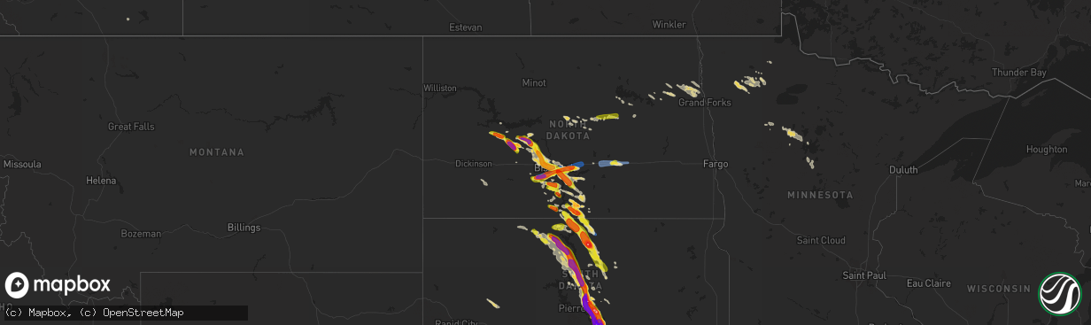
Hail Map on August 6, 2019
The weather event on August 6, 2019 includes Wind and Hail maps. 28 states and 779 cities were impacted and suffered possible damage. The total estimated number of properties impacted is 111,123.
Want more than just the map?
Turn this storm into a full workflow.
- Owner + property data so you know who to knock
- OnDemand branded weather history reports to win the "did we even have hail?" argument
- RoofTrace estimate so reps stop guessing numbers at the door
Bought this map? Upgrade within 7 days and we'll credit the $230. (10-15 min setup call)
Wind
Hail
111,123
Estimated number of impacted properties by a 1.00" hail or larger24,225
Estimated number of impacted properties by a 1.75" hail or larger5,807
Estimated number of impacted properties by a 2.50" hail or largerStates Impacted by Hail Map on August 6, 2019
Storm reports
Mississippi
| Date | Description |
|---|---|
| 08/06/20191:06 AM CDT | Trees down on county road 500. Time is radar estimated. |
New Mexico
| Date | Description |
|---|---|
| 08/05/20198:55 PM CDT | At 155 PM MDT, a severe thunderstorm was located near Pilar, or 11 miles west of Taos, moving east at 10 mph. HAZARD...60 mph wind gusts and half dollar size hail. SOURCE...Radar indicated. IMPACT...Hail damage to vehicles is expected. Expect wind damage to roofs, siding, and trees. Locations impacted include... Taos, Ranchos De Taos, Pilar, Talpa, Los Cordovas, El Prado, Arroyo Seco and Taos Pueblo. |
Texas
| Date | Description |
|---|---|
| 08/06/20192:58 AM CDT | At 757 PM CDT, a severe thunderstorm was located near Laverne, moving south at 10 mph. HAZARD...60 mph wind gusts and quarter size hail. SOURCE...Radar indicated. IMPACT...Hail damage to vehicles is expected. Expect wind damage to roofs, siding, and trees. Locations impacted include... Laverne and Catesby. |
| 08/06/20191:43 AM CDT | At 643 PM CDT, a severe thunderstorm was located 4 miles east of Wolf Creek Park, or 16 miles west of Lipscomb, moving west at 5 mph. HAZARD...60 mph wind gusts and half dollar size hail. SOURCE...Radar indicated. IMPACT...Minor damage to roofs, siding, and trees is possible. Hail damage to vehicles is expected. Locations impacted include... Wolf Creek Park. |
District of Columbia
| Date | Description |
|---|---|
| 08/06/20196:58 PM CDT | Tree down in 3200 block of aberfoyle place nw. |
| 08/06/20192:57 AM CDT | At 757 PM EDT, a severe thunderstorm was located over Beltsville, moving east at 5 mph. HAZARD...60 mph wind gusts and quarter size hail. SOURCE...Radar indicated. IMPACT...Damaging winds will cause some trees and large branches to fall. This could injure those outdoors, as well as damage homes and vehicles. Roadways may become blocked by downed trees. Localized power outages are possible. Unsecured light objects may become projectiles. Locations impacted include... Bowie, College Park, Greenbelt, Langley Park, Beltsville, Bladensburg, University of Maryland, Laurel, Fairland, Landover, Hyattsville, White Oak, Takoma Park, East Riverdale, Adelphi, Colesville, New Carrollton, Mitchellville, Fort Meade and Riverdale Park. |
| 08/06/20192:22 AM CDT | At 722 PM EDT, a severe thunderstorm was located over Potomac, or over American Legion Bridge, moving east at 15 mph. HAZARD...60 mph wind gusts. SOURCE...Radar indicated. IMPACT...Damaging winds will cause some trees and large branches to fall. This could injure those outdoors, as well as damage homes and vehicles. Roadways may become blocked by downed trees. Localized power outages are possible. Unsecured light objects may become projectiles. Locations impacted include... Rockville, Bethesda, American Legion Bridge, Fort Totten, Aspen Hill, Potomac, North Bethesda, White Oak, Takoma Park, Wolf Trap, Colesville, Kemp Mill, Chevy Chase, North Kensington, South Kensington, Forest Glen, Hillandale, Martin's Additions, North Chevy Chase and American University. |
| 08/05/20198:02 PM CDT | Tree down on 16th street nw near intersection with floral street nw. |
| 08/05/20197:32 PM CDT | Tree down on 16th street nw near intersection with floral street nw. Corrected event time. |
Utah
| Date | Description |
|---|---|
| 08/06/20196:53 PM CDT | Asos station kcny canyonlands field airport. |
Ohio
| Date | Description |
|---|---|
| 08/06/20195:22 PM CDT | Tree down on a house involving power lines. |
| 08/06/20195:14 PM CDT | Report of a tree down in walnut creek township. |
| 08/06/20194:40 PM CDT | Tree damage observed by law enforcement and the public. |
| 08/06/20194:27 PM CDT | Delayed report. Multiple trees snapped and uprooted on millersburg road. |
| 08/06/20194:20 PM CDT | An ef1 tornado briefly touched down in huron county on tuesday evening approximately 1.5 miles south of downtown norwalk. The tornado started near us20 approximately 0. |
| 08/06/20193:23 PM CDT | Tree branch down on power pole... Causing fire. |
| 08/06/20193:14 PM CDT | Tree down on 303 and coit road... Blocking the road. |
| 08/06/20192:55 PM CDT | Tree down. Time estimated from radar. |
| 08/06/20192:10 PM CDT | Tree down. Time estimated from radar. |
| 08/06/20192:09 PM CDT | Tree down over power line. Time estimated from radar. |
| 08/06/20192:06 PM CDT | One half of a tree down. Time estimated from radar. |
| 08/06/20192:00 PM CDT | Tree down on road. |
| 08/06/20191:57 PM CDT | Six big limbs down. Time estimated from radar. |
| 08/06/20191:51 PM CDT | Multiple trees and large limbs down... Tents blown over in and around courthouse square. |
| 08/06/20191:51 PM CDT | Multiple trees down. |
| 08/06/20191:50 PM CDT | Trees and wires down throughout the city. |
| 08/06/20191:45 PM CDT | Corrects previous tstm wnd dmg report from 1 sw sandusky. Utility pole struck by lighting... Causing fire... Not by storm damage. ----- power lines knocked down onto ut |
| 08/06/20191:31 PM CDT | Tree down. |
| 08/06/20191:24 PM CDT | Tree and limbs down. |
| 08/06/20191:24 PM CDT | Tree fell on county sheriff vehicle. |
| 08/06/20191:13 PM CDT | Tree down on power line... Snapped utility pole. |
| 08/06/201912:48 PM CDT | Large limbs and some trees down. |
| 08/06/201912:45 PM CDT | Multiple trees down throughout pepper pike. |
| 08/06/201911:45 AM CDT | Numerous trees down. |
| 08/06/201911:12 AM CDT | Tree down across route 2. |
| 08/06/201910:23 AM CDT | Tree down on house. |
| 08/06/20196:48 AM CDT | At 1148 AM EDT, severe thunderstorms were located along a line extending from 7 miles northeast of Oak Harbor to near Fremont, moving northeast at 30 mph. HAZARD...60 mph wind gusts. SOURCE...Radar indicated. IMPACT...Expect damage to trees and power lines. Locations impacted include... Sandusky, Fremont, Port Clinton, Kelleys Island, Put-In-Bay, Bellevue, Clyde, Oak Harbor, Green Springs, Castalia, Ballville, Catawba Island, Marblehead, Bettsville, Bay View, Lindsey, Rocky Ridge, Bloomingville, Sandusky South and Stony Prairie. |
| 08/06/201912:21 AM CDT | At 521 PM EDT, a severe thunderstorm was located over Gambier, or near Mount Vernon, moving northeast at 40 mph. HAZARD...60 mph wind gusts and penny size hail. SOURCE...Radar indicated. IMPACT...Expect damage to trees and power lines. Locations impacted include... Mount Vernon, Millersburg, Berlin, Walnut Creek, Loudonville, Fredericktown, Gambier, Danville, Killbuck, Holmesville, Glenmont, Nashville, Winesburg, Farmerstown, Baltic, Gann, North Liberty, Mount Hope and Charm. |
| 08/06/201912:04 AM CDT | At 504 PM EDT, a severe thunderstorm was located over Hubbard, or near Youngstown, moving east at 40 mph. HAZARD...60 mph wind gusts. SOURCE...Radar indicated. IMPACT...Expect damage to trees and power lines. Locations impacted include... Youngstown, Warren, Boardman, Niles, Campbell, Hubbard, Lordstown, Vienna Center, Hilltop, Maplewood Park, Austintown, Struthers, Girard, Vienna, McDonald, Poland, New Middletown, Lowellville, Orangeville and Yankee Lake. |
| 08/05/201911:15 PM CDT | At 415 PM EDT, a severe thunderstorm was located near Marysville, moving east at 25 mph. HAZARD...60 mph wind gusts. SOURCE...Radar indicated. IMPACT...Expect damage to trees and power lines. Locations impacted include... Dublin, Marysville, Plain City, New California, Unionville Center, Watkins, Chuckery and US Route 33 at US Route 42. |
| 08/05/201911:12 PM CDT | At 412 PM EDT, severe thunderstorms were located along a line extending from near Orwell to near Newton Falls to near Ravenna to near Mogadore, moving northeast at 30 mph. HAZARD...60 mph wind gusts and penny size hail. SOURCE...Radar indicated. IMPACT...Expect damage to trees and power lines. Locations impacted include... Warren, Ravenna, Kent, Niles, Tallmadge, Streetsboro, Cortland, Newton Falls, Mogadore, South Russell, Lordstown, Middlefield, Garrettsville, Kinsman, North Bloomfield, Orwell, Burton, Andover, Mantua and West Farmington. |
| 08/05/201911:04 PM CDT | At 403 PM EDT, a severe thunderstorm was located near New Wilmington, or 8 miles south of Hermitage, moving northeast at 25 mph. HAZARD...Wind gusts to 60 mph and quarter-size hail. SOURCE...Radar. IMPACT...Minor hail damage to vehicles is possible. Expect wind damage to trees and power lines, resulting in some power outages. Locations impacted include... New Castle... Hermitage... New Wilmington... Oakwood... New Castle Northwest... Mercer... Pulaski... Stoneboro... West Middlesex... Sandy Lake... Clark... Fredonia...This includes the following highways... Interstate 79 in Pennsylvania between mile markers 114 and 134. Interstate 80 in Pennsylvania between mile markers 3 and 23. Interstate 376 in Pennsylvania between mile markers 4 and 13. |
| 08/05/201910:37 PM CDT | At 337 PM EDT, a severe thunderstorm was located 7 miles southeast of North Royalton, or 12 miles northwest of Akron, moving east at 30 mph. HAZARD...60 mph wind gusts and quarter size hail. SOURCE...Radar indicated. IMPACT...Minor damage to vehicles is possible. Expect damage to trees and power lines. Locations impacted include... Akron, Ravenna, Cuyahoga Falls, Kent, Solon, Hudson, Twinsburg, Streetsboro, Macedonia, Mantua, Stow, Broadview Heights, Aurora, Brecksville, Bedford, Seven Hills, Bedford Heights, Fairlawn, Independence and Northfield. |
| 08/05/201910:08 PM CDT | At 308 PM EDT, a severe thunderstorm was located near Wilmington, moving east at 45 mph. HAZARD...60 mph wind gusts. SOURCE...Radar indicated. IMPACT...Expect damage to trees and power lines. Locations impacted include... Wilmington, Sabina, Clarksville, Melvin, Bloomington, New Antioch, Oakland, Cuba, Lees Creek, Reesville, Ogden, Burtonville and Cowan Lake State Park.This includes I-71 in Ohio between mile markers 43 and 48. |
| 08/05/20199:57 PM CDT | At 257 PM EDT, severe thunderstorms were located along a line extending from Wellington to near Loudonville, moving northeast at 30 mph. HAZARD...60 mph wind gusts. SOURCE...Radar indicated. IMPACT...Expect damage to trees and power lines. Locations impacted include... Medina, Wooster, Ashland, Brunswick, Wadsworth, Orrville, Grafton, Rittman, Wellington, Doylestown, Lodi, Creston, Dalton, Shreve, West Salem, Chippewa Lake, Hayesville, Polk, Mount Eaton and Broadview Heights. |
| 08/05/20199:06 PM CDT | At 204 PM EDT, severe thunderstorms were located along a line extending from near Milan to Plymouth, moving northeast at 25 mph. HAZARD...60 mph wind gusts. SOURCE...Radar indicated. IMPACT...Expect damage to trees and power lines. Locations impacted include... Lorain, Norwalk, Western Vermilion, Vermilion, Amherst, Willard, Wellington, New London, Plymouth, Northern Milan, Milan, Wakeman, Savannah, Oberlin, South Amherst, Pittsfield, Greenwich, Berlin Heights, North Fairfield and Bailey Lakes. |
| 08/05/20198:47 PM CDT | At 147 PM EDT, severe thunderstorms were located along a line extending from near Cleveland Heights to Solon, moving northeast at 25 mph. HAZARD...60 mph wind gusts. SOURCE...Radar indicated. IMPACT...Expect damage to trees and power lines. Locations impacted include... Cleveland, Painesville, Willowick, Chardon, Fairport Harbor, Euclid, Mentor, Cleveland Heights, Solon, Willoughby, Eastlake, Warrensville Heights, South Russell, Middlefield, Burton, Highland Hills, Timberlake, Lakeline, Chesterland and Garfield Heights. |
| 08/05/20198:13 PM CDT | At 113 PM EDT, a severe thunderstorm was located near North Ridgeville, or 7 miles east of Elyria, moving east at 20 mph. HAZARD...60 mph wind gusts. SOURCE...Radar indicated. IMPACT...Expect damage to trees and power lines. Locations impacted include... Cleveland, Parma, Lakewood, Strongsville, Westlake, North Royalton, North Ridgeville, Grafton, North Olmsted, Garfield Heights, Avon, Parma Heights, Rocky River, Broadview Heights, Brook Park, Berea, Fairview Park, Middleburg Heights, Bay Village and Brecksville. |
| 08/05/20197:51 PM CDT | Wind damage to shed and deck... Along with missing shingles from roof. Several downed trees. |
Tennessee
| Date | Description |
|---|---|
| 08/06/20194:43 AM CDT | At 943 PM CDT, severe thunderstorms were located along a line extending from 11 miles north of Manchester to 6 miles north of Petersburg, moving southeast at 35 mph. HAZARD...60 mph wind gusts. SOURCE...Radar indicated. IMPACT...Expect damage to roofs, siding, and trees. Locations impacted include... Shelbyville, Lewisburg, Manchester, Tullahoma, Chapel Hill, Wartrace, Bell Buckle, Normandy, Christiana, Beechgrove, Raus, Fosterville, Rover, Belfast, Deason, Hillsboro, Farmington and Unionville.This includes Interstate 24 between mile markers 85 and 127. |
| 08/06/20194:07 AM CDT | At 907 PM CDT, severe thunderstorms were located along a line extending from 8 miles northwest of Woodbury to 6 miles east of Spring Hill, moving southeast at 40 mph. HAZARD...60 mph wind gusts. SOURCE...Radar indicated. IMPACT...Expect damage to roofs, siding, and trees. Locations impacted include... Murfreesboro, Shelbyville, McMinnville, Lewisburg, Manchester, Woodbury, Walterhill, Chapel Hill, Cornersville, Morrison, Wartrace, Eagleville, Bell Buckle, Auburntown, Centertown, Normandy, Viola, Beechgrove, Raus and Fosterville.This includes the following highways... Interstate 65 between mile markers 23 and 26. Interstate 24 between mile markers 72 and 113. Interstate 840 between mile markers 37 and 57. |
| 08/06/20193:34 AM CDT | At 834 PM CDT, severe thunderstorms were located along a line extending from near Lebanon to near Forest Hills, moving southeast at 40 mph. HAZARD...60 mph wind gusts and penny size hail. SOURCE...Radar indicated. IMPACT...Expect damage to roofs, siding, and trees. Locations impacted include... Murfreesboro, Lebanon, Nashville, Madison, Smyrna, Brentwood, La Vergne, Mount Juliet, Goodlettsville, Nolensville, Forest Hills, Oak Hill, Lakewood, Watertown, Hermitage, Walterhill, Rural Hill, Antioch, Belinda City and Old Hickory.This includes the following highways... Interstate 40 between mile markers 204 and 243. Interstate 65 between mile markers 71 and 97. Interstate 24 between mile markers 36 and 84. Interstate 840 between mile markers 36 and 76. |
| 08/06/20192:58 AM CDT | At 758 PM CDT, a severe thunderstorm was located over Millersville, or 11 miles southeast of Springfield, moving south at 50 mph. HAZARD...70 mph wind gusts and penny size hail. SOURCE...Radar indicated. IMPACT...Expect considerable tree damage. Damage is likely to mobile homes, roofs, and outbuildings. Locations impacted include... Gallatin, Lebanon, Nashville, Madison, Hendersonville, Mount Juliet, Goodlettsville, White House, Millersville, Greenbrier, Coopertown, Lakewood, Ridgetop, Hermitage, Rural Hill, Belinda City, Old Hickory, Joelton, Berry Hill and Bledsoe Creek State Park.This includes the following highways... Interstate 40 between mile markers 207 and 249. Interstate 65 between mile markers 79 and 109. Interstate 24 between mile markers 27 and 57. Interstate 840 between mile markers 70 and 76. |
| 08/06/20192:16 AM CDT | At 716 PM CDT, a severe thunderstorm was located near Russellville, moving southeast at 55 mph. HAZARD...60 mph wind gusts. SOURCE...Radar indicated. IMPACT...Expect damage to roofs, siding, and trees. Locations impacted include... Russellville, Auburn, Adairville, Justice, Gordonsville, Spa, Epleys, Black Jack, Dennis and Geddes. |
| 08/06/20191:23 AM CDT | At 623 PM CDT, a severe thunderstorm was located 9 miles north of Springfield, moving east at 10 mph. HAZARD...60 mph wind gusts and quarter size hail. SOURCE...Radar indicated. IMPACT...Hail damage to vehicles is expected. Expect wind damage to roofs, siding, and trees. Locations impacted include... Adairville, Keysburg, Neosheo, Schochoh, Middleton, Dot, Schweizer, Prices Mill and Schley. |
| 08/06/20191:19 AM CDT | At 619 PM CDT, a severe thunderstorm was located 10 miles northwest of Springfield, moving east at 15 mph. HAZARD...60 mph wind gusts and quarter size hail. SOURCE...Radar indicated. IMPACT...Hail damage to vehicles is expected. Expect wind damage to roofs, siding, and trees. Locations impacted include... Springfield, Cross Plains, Orlinda, Adams and Cedar Hill. |
| 08/05/20199:47 PM CDT | A local report indicates 60 MPH wind near 1 N NORMANDY |
| 08/05/20199:40 PM CDT | Numerous trees and power lines were blown down across eastern hickman county including on hwy 50 east...swan creek road...ugly creek road...falls branch road...blue buc |
| 08/05/20199:13 PM CDT | Tree snapped near barfield crescent park |
| 08/05/20199:10 PM CDT | Powerlines and several large tree limbs down on millsfield highway near cloverdale. Time estimated. |
| 08/05/20199:00 PM CDT | Large tree limb fell on vehicle. |
| 08/05/20198:50 PM CDT | Trees down at nolensville rd and pettus rd |
| 08/05/20198:37 PM CDT | Tree down in sylvan park |
| 08/05/20198:34 PM CDT | Tree and power lines down in roadway at 727 rome pike |
| 08/05/20198:32 PM CDT | Tree in roadway at 435 spring creek road |
| 08/05/20198:30 PM CDT | Tree on car |
| 08/05/20198:29 PM CDT | Tree in roadway at 430 s rutland rd |
| 08/05/20198:26 PM CDT | Tree down across graylynn drive |
| 08/05/20198:22 PM CDT | Tree in roadway at beckwith road and lebanon road |
| 08/05/20198:21 PM CDT | Trees down |
| 08/05/20198:05 PM CDT | Trees and power lines down throughout town. |
| 08/05/20198:05 PM CDT | A local report indicates 60 MPH wind near GREENBRIER |
| 08/05/20198:00 PM CDT | Nws employee reported numerous trees and tree limbs down across white house |
| 08/05/20197:55 PM CDT | A local report indicates 60 MPH wind near 3 E SPRINGFIELD |
| 08/05/20197:55 PM CDT | Numerous trees and power lines blown down across robertson county with several roadways blocked...including hwy 76 at new hall road...kinneys road...glen raven road at |
Indiana
| Date | Description |
|---|---|
| 08/06/20193:31 PM CDT | A local report indicates 1.00 inch wind near 1 SE OTTO |
| 08/05/201910:44 PM CDT | At 344 PM EDT, a severe thunderstorm was located near Versailles, moving east at 25 mph. HAZARD...60 mph wind gusts. SOURCE...Radar indicated. IMPACT...Expect damage to trees and power lines. Locations impacted include... Aurora, Milan, Dillsboro, Moores Hill, Wilmington, Hartford, Mount Sinai and Cold Springs. |
New Jersey
| Date | Description |
|---|---|
| 08/06/20196:50 PM CDT | Trees down onto wires and on fire. Time estimated from radar. |
| 08/06/20196:42 PM CDT | Several trees reported down in belvidere. Time estimated from radar. |
| 08/06/20196:40 PM CDT | Tree down into the roadway near 312 water street. Time estimated from radar. |
| 08/06/20191:08 PM CDT | Downed tree on nj-50 in both directions south of gibson creek rd. All lanes were closed. Time estimated from radar. |
| 08/06/20193:05 AM CDT | At 805 PM EDT, a severe thunderstorm was located over Oxford, or 14 miles northeast of Easton, moving east at 15 mph. HAZARD...60 mph wind gusts and quarter size hail. SOURCE...Radar indicated. IMPACT...Minor damage to vehicles is possible. Wind damage to roofs, siding, trees, and power lines is possible. Locations impacted include... Hackettstown, Washington, Belvidere, Oxford, Glen Gardner, Chester, Hampton, Califon, Great Meadows-Vienna, Brass Castle, Pleasant Valley, Long Valley, Budd Lake, Beatyestown, Allamuchy-Panther Valley and Beattyestown. |
| 08/05/20197:10 PM CDT | Tree down across the roadway at brass castle road and fox chase road. Time estimated from radar. |
Missouri
| Date | Description |
|---|---|
| 08/06/20196:00 PM CDT | Tree uprooted. Minor roof damage to a building. Late report. Time estimated from radar. |
| 08/06/20195:00 PM CDT | Reported near along hwy 25 near delta. |
| 08/06/20194:53 PM CDT | 45-50 mph winds and 4 inch tree limb down. Pea size hail. |
| 08/06/20194:11 PM CDT | A local report indicates 1.00 inch wind near CALEDONIA |
| 08/06/20193:23 PM CDT | Quarter size hail increasing in size to near half dollar size during conversation. |
| 08/06/20193:06 PM CDT | County dispatch reports two trees down across the road. |
| 08/06/20192:46 PM CDT | Mping report. |
| 08/06/20192:45 PM CDT | Live tree snapped in half... Report of dime-sized hail as well from facebook report. |
| 08/06/20192:40 PM CDT | Via picture on facebook. |
| 08/06/20192:39 PM CDT | Large trees snapped. Time estimated from radar. Twitter report. |
| 08/06/20192:30 PM CDT | Reported at 2578 sugar lake rd pacific mo... Pictures submitted to office indicate multiple live trees snapped. |
| 08/06/20193:15 AM CDT | At 815 PM CDT, a severe thunderstorm was located over Marmaduke, moving southeast at 45 mph. HAZARD...60 mph wind gusts and quarter size hail. SOURCE...Radar indicated. IMPACT...Hail damage to vehicles is expected. Expect wind damage to roofs, siding, and trees. Locations impacted include... Paragould, Blytheville, Gosnell, Manila, Lake City, Leachville, Rector, Senath, Monette, Caraway, Marmaduke, Oak Grove Heights, Cardwell, Hornersville, Arbyrd, Lafe, Knobel, Dell, Peach Orchard and Delaplaine. |
| 08/06/20192:52 AM CDT | At 752 PM CDT, a severe thunderstorm was located 7 miles southeast of Alton, or 14 miles northeast of Thayer, moving south at 25 mph. HAZARD...60 mph wind gusts and penny size hail. SOURCE...Radar indicated. IMPACT...Expect damage to roofs, siding, and trees. Locations impacted include... Myrtle... Couch... |
| 08/06/20192:49 AM CDT | At 749 PM CDT, a severe thunderstorm was located near Datto, or near Corning, moving southeast at 35 mph. HAZARD...60 mph wind gusts and quarter size hail. SOURCE...Radar indicated. IMPACT...Hail damage to vehicles is expected. Expect wind damage to roofs, siding, and trees. Locations impacted include... Corning, Marmaduke, Oak Grove Heights, Lafe, Knobel, Peach Orchard, Datto, Beech Grove, Heelstring, Stonewall, Tipperary, Gainesville, Knob, Twin Oaks and Palatka. |
| 08/06/201912:15 AM CDT | At 514 PM CDT, a severe thunderstorm was located 9 miles northwest of Arcadia, or 10 miles southwest of Fort Scott, moving southeast at 40 mph. HAZARD...60 mph wind gusts and quarter size hail. SOURCE...Radar indicated. IMPACT...Hail damage to vehicles is expected. Expect wind damage to roofs, siding, and trees. Locations impacted include... Pittsburg... Prairie State Park... Fort Scott... Frontenac... Girard... Arma... Liberal... Cherokee... Mulberry... Chicopee... Nashville... Mindenmines... Franklin... Arcadia... Hepler... Burgess... Beulah... Croweburg... Yale... Petersburg... |
| 08/05/201911:59 PM CDT | At 458 PM CDT, severe thunderstorms were located along a line extending from near Arcadia to 7 miles northeast of Reynolds, moving south at 25 mph. HAZARD...60 mph wind gusts and half dollar size hail. SOURCE...Radar indicated. IMPACT...Hail damage to vehicles is expected. Expect wind damage to roofs, siding, and trees. Locations impacted include... Ironton, Reynolds, Ellington, Arcadia, Annapolis, Glover, Oates, Garwood, Centerville, Des Arc, Corridon, Redford, Hogan, Vulcan, Black, Sabula, Chloride and Lesterville.This also includes Johnsons Shut-Ins State Park, Taum Sauk MountainState Park, and Clearwater Lake Recreational Area. |
| 08/05/201911:48 PM CDT | At 447 PM CDT, a severe thunderstorm was located near Delta, or 8 miles south of Bollinger Mill State Historic Site, moving southeast at 15 mph. HAZARD...60 mph wind gusts and quarter size hail. SOURCE...Radar indicated. IMPACT...Hail damage to vehicles is expected. Expect wind damage to roofs, siding, and trees. Locations impacted include... Delta, Dutchtown, Whitewater and Allenville. |
| 08/05/201911:43 PM CDT | At 443 PM CDT, a severe thunderstorm was located 7 miles east of Cherryville, moving southeast at 25 mph. HAZARD...60 mph wind gusts and half dollar size hail. SOURCE...Radar indicated. IMPACT...Hail damage to vehicles is expected. Expect wind damage to roofs, siding, and trees. Locations impacted include... Viburnum, Courtois, Bixby, Davisville and Dillard. |
| 08/05/201911:15 PM CDT | At 415 PM CDT, a severe thunderstorm was located near Belleview, moving southeast at 25 mph. HAZARD...60 mph wind gusts and half dollar size hail. SOURCE...Trained weather spotters. IMPACT...Hail damage to vehicles is expected. Expect wind damage to roofs, siding, and trees. Locations impacted include... Ironton, Pilot Knob, Iron Mountain Lake, Arcadia, Iron Mountain, Belleview, Roselle, Caledonia, Hogan and Granite.This also includes Fort Davidson Historic Site and Elephant RocksState Park. |
| 08/05/201910:57 PM CDT | At 357 PM CDT, a severe thunderstorm was located near Scott City, moving southeast at 20 mph. HAZARD...60 mph wind gusts and quarter size hail. SOURCE...Radar indicated. IMPACT...Hail damage to vehicles is expected. Expect wind damage to roofs, siding, and trees. Locations impacted include... Cape Girardeau, Scott City, Tamms, Kelso, Olive Branch, Horseshoe Lake Conservation Area, Thebes, Commerce and East Cape Girardeau.This includes Interstate 55 between Mile Markers 86 and 94. |
| 08/05/201910:26 PM CDT | At 325 PM CDT, a severe thunderstorm was located over Potosi, moving southeast at 30 mph. HAZARD...60 mph wind gusts and half dollar size hail. SOURCE...Trained weather spotters. IMPACT...Hail damage to vehicles is expected. Expect wind damage to roofs, siding, and trees. Locations impacted include... Farmington, Desloge, Potosi, Bismarck, Leadwood, Park Hills, Iron Mountain Lake, Irondale, Mineral Point, Leadington and Frankclay.This also includes St. Joe State Park and Missouri Mines HistoricSite. |
| 08/05/20199:44 PM CDT | At 244 PM CDT, a severe thunderstorm was located near Miramiguoa Park, moving southeast at 25 mph. HAZARD...60 mph wind gusts and quarter size hail. SOURCE...Radar indicated. IMPACT...Hail damage to vehicles is expected. Expect wind damage to roofs, siding, and trees. Locations impacted include... Richwoods. |
| 08/05/20199:36 PM CDT | At 235 PM CDT, a severe thunderstorm was located over Pacific, moving southeast at 25 mph. HAZARD...60 mph wind gusts and quarter size hail. SOURCE...Radar indicated. IMPACT...Hail damage to vehicles is expected. Expect wind damage to roofs, siding, and trees. Locations impacted include... Wildwood, Washington, Union, Eureka, Pacific, Byrnes Mill, Gray Summit, Villa Ridge, High Ridge, Barnhart, Cedar Hill, Antonia, Cedar Hill Lakes, House Springs, Dittmer, Lonedell, Imperial, Scotsdale, Parkdale and Oermann.This includes the following highways... Interstate 44 in Missouri between exits 247 and 266. Interstate 55 in Missouri near exit 185.This also includes Route 66 State Park, Sandy Creek Covered BridgeHistoric Site, and Robertsville State Park. |
| 08/05/20198:53 PM CDT | At 153 PM CDT, a severe thunderstorm was located over Lake St. Louis, moving southeast at 30 mph. HAZARD...60 mph wind gusts and quarter size hail. SOURCE...Radar indicated. IMPACT...Hail damage to vehicles is expected. Expect wind damage to roofs, siding, and trees. Locations impacted include... O'Fallon, St. Charles, St. Peters, Chesterfield, Wildwood, University City, Ballwin, Wentzville, Maryland Heights, Manchester, Creve Coeur, Overland, Lake St. Louis, St. Ann, Bridgeton, Dardenne Prairie, Town and Country, Eureka, Ellisville and Ladue.This includes the following highways... Interstate 44 in Missouri between exits 261 and 266. Interstate 70 in Missouri between exits 208 and 231.This also includes Babler Memorial State Park, Route 66 State Park,Castlewood State Park, and First Missouri State Capitol HistoricSite. |
Colorado
| Date | Description |
|---|---|
| 08/06/20195:55 PM CDT | Delayed report. Follow-up call from spotter confirmed a few quarters were found in field after storm passed. |
| 08/06/20192:44 AM CDT | At 744 PM MDT, a severe thunderstorm was located 12 miles southwest of Granada, or 15 miles southeast of Lamar, moving south at 20 mph. HAZARD...60 mph wind gusts and half dollar size hail. SOURCE...Radar indicated. IMPACT...Hail damage to vehicles is expected. Expect wind damage to roofs, siding, and trees. This severe thunderstorm will remain over mainly rural areas of south central Prowers County. |
| 08/06/20192:00 AM CDT | At 659 PM MDT, a severe thunderstorm was located 7 miles west of Bristol, or 9 miles northeast of Lamar, moving south at 25 mph. HAZARD...60 mph wind gusts and quarter size hail. SOURCE...Radar indicated. IMPACT...Hail damage to vehicles is expected. Expect wind damage to roofs, siding, and trees. Locations impacted include... Areas west of Granada and Bristol, and east of Lamar. |
| 08/06/20191:36 AM CDT | At 635 PM MDT, a severe thunderstorm was located 9 miles southeast of Queens Reservoir, or 13 miles northeast of Lamar, moving south at 15 mph. HAZARD...60 mph wind gusts and half dollar size hail. SOURCE...Radar indicated. IMPACT...Hail damage to vehicles is expected. Expect wind damage to roofs, siding, and trees. Locations impacted include... Bristol. |
| 08/06/201912:07 AM CDT | At 507 PM MDT, a severe thunderstorm was located 8 miles south of Bethune, or 9 miles southwest of Burlington, moving southeast at 25 mph. HAZARD...60 mph wind gusts and half dollar size hail. SOURCE...Radar indicated. IMPACT...Hail damage to vehicles is expected. Expect wind damage to roofs, siding, and trees. This severe thunderstorm will remain over mainly rural areas of southeastern Kit Carson County.This includes Highway 385 between mile markers 170 and 183. |
| 08/06/201912:06 AM CDT | At 506 PM MDT, a severe thunderstorm was located 9 miles southwest of Kit Carson, or 30 miles southwest of Cheyenne Wells, moving south at 25 mph. HAZARD...70 mph wind gusts and ping pong ball size hail. SOURCE...Radar indicated. IMPACT...People and animals outdoors will be injured. Expect hail damage to roofs, siding, windows, and vehicles. Expect considerable tree damage. Wind damage is also likely to mobile homes, roofs, and outbuildings. Locations impacted include... Eads. |
| 08/05/201911:28 PM CDT | At 428 PM MDT, a severe thunderstorm was located 7 miles north of Kit Carson, or 24 miles west of Cheyenne Wells, moving southeast at 25 mph. HAZARD...60 mph wind gusts and quarter size hail. SOURCE...Radar indicated. IMPACT...Hail damage to vehicles is expected. Expect wind damage to roofs, siding, and trees. Locations impacted include... Kit Carson, Wild Horse and Firstview. |
South Dakota
| Date | Description |
|---|---|
| 08/06/20196:53 PM CDT | A few quarter sized hailstones as well. |
| 08/06/20196:50 PM CDT | A local report indicates 1.75 inch wind near ONIDA |
| 08/06/20196:43 PM CDT | Garden crops damaged and some flattened. |
| 08/06/20196:43 PM CDT | 18 inch diameter tree down on power lines. |
| 08/06/20196:39 PM CDT | All windows on north side of house broken out. |
| 08/06/20196:35 PM CDT | 3 inch diameter branch down. A few quarter size hail... But mostly dime to nickel size. |
| 08/06/20196:25 PM CDT | Winds estimated at at least 80 mph. Hail as large as tennis balls... Although most were smaller. Hail accumulated in drifts that were 7 to 8 inches deep. Wind driven ha |
| 08/06/20196:23 PM CDT | 1.75 inch hail also reported. |
| 08/06/20196:23 PM CDT | A local report indicates 1.75 inch wind near 1 NNW WHITLOCKS BAY REC |
| 08/06/20195:24 PM CDT | 40 mph wind estimate. Corn crop was stripped. |
| 08/06/20195:04 PM CDT | A local report indicates 59 MPH wind near 4 W TRAIL CITY |
| 08/06/20195:00 PM CDT | Depth of hail was 5 inches. Corn crop was stripped. |
| 08/06/20194:45 PM CDT | Ground became white with hail. |
| 08/06/20194:25 PM CDT | Most hailstones between nickel and quarter size. |
| 08/06/20194:00 PM CDT | Brief hail between nickel and quarter size. |
| 08/06/20196:05 AM CDT | At 1104 PM CDT, severe thunderstorms were located along a line extending from Lynch to near Spencer to 8 miles south of Naper, moving south at 40 mph. HAZARD...Golf ball size hail and 70 mph wind gusts. SOURCE...Radar indicated. IMPACT...People and animals outdoors will be injured. Expect hail damage to roofs, siding, windows, and vehicles. Expect considerable tree damage. Wind damage is also likely to mobile homes, roofs, and outbuildings. Severe thunderstorms will be near... Lynch around 1110 PM CDT. Stuart around 1130 PM CDT. Atkinson around 1135 PM CDT. O'Neill and Page around 1145 PM CDT.Other locations impacted by these severe thunderstorms includeBristow, Dustin, Emmet, Scottville, Inman, Redbird State WildlifeManagement Area, Hull Lake State Wildlife Management Area,Opportunity, Spencer Dam and Midway.This includes the following highways... Highway 20 between mile markers 276 and 328. Highway 281 between mile markers 174 and 223. Highway 12 between mile markers 82 and 131. |
| 08/06/20195:46 AM CDT | At 1046 PM CDT, a severe thunderstorm was located over Naper, or 22 miles west of Spencer, moving south at 85 mph. HAZARD...Golf ball size hail and 70 mph wind gusts. SOURCE...Radar indicated. IMPACT...People and animals outdoors will be injured. Expect hail damage to roofs, siding, windows, and vehicles. Expect considerable tree damage. Wind damage is also likely to mobile homes, roofs, and outbuildings. Locations impacted include... Naper, Dustin and Brocksburg. This includes Highway 12 between mile markers 74 and 103. |
| 08/06/20195:33 AM CDT | At 1032 PM CDT, a severe thunderstorm was located near Burke, or 32 miles east of Winner, moving south at 40 mph. This is a very dangerous storm. HAZARD...Baseball size hail and 70 mph wind gusts. SOURCE...Public. IMPACT...People and animals outdoors will be severely injured. Expect shattered windows, extensive damage to roofs, siding, and vehicles. This severe thunderstorm will be near... Herrick around 1045 PM CDT. St. Charles around 1050 PM CDT.Other locations impacted by this severe thunderstorm include Fairfax. |
| 08/06/20195:32 AM CDT | At 1032 PM CDT, a severe thunderstorm was located near Bonesteel, or 13 miles northwest of Spencer, moving southeast at 30 mph. HAZARD...70 mph wind gusts and half dollar size hail. SOURCE...Radar indicated. IMPACT...Hail damage to vehicles is expected. Expect considerable tree damage. Wind damage is also likely to mobile homes, roofs, and outbuildings. This severe thunderstorm will be near... Butte around 1045 PM CDT. Spencer and Gross around 1100 PM CDT. Lynch around 1115 PM CDT.Other locations impacted by this severe thunderstorm include SpencerDam, Bristow, Parshall Bridge State Wildlife Management Area, HullLake State Wildlife Management Area, Anncar and Anoka.This includes the following highways... Highway 281 between mile markers 208 and 223. Highway 12 between mile markers 97 and 131. |
| 08/06/20195:04 AM CDT | At 1003 PM CDT, a severe thunderstorm was located near Iona, or 21 miles south of Chamberlain, moving southeast at 45 mph. HAZARD...Two inch hail and 70 mph wind gusts. SOURCE...Radar indicated. IMPACT...People and animals outdoors will be injured. Expect hail damage to roofs, siding, windows, and vehicles. Expect considerable tree damage. Wind damage is also likely to mobile homes, roofs, and outbuildings. This severe thunderstorm will be near... Burke around 1030 PM CDT. Herrick around 1040 PM CDT.Other locations impacted by this severe thunderstorm include Dixon InGregory County. |
| 08/06/20194:45 AM CDT | At 945 PM CDT, a severe thunderstorm was located near Dude Ranch, or 12 miles west of Chamberlain, moving southeast at 40 mph. HAZARD...Ping pong ball size hail and 60 mph wind gusts. SOURCE...Radar indicated. IMPACT...People and animals outdoors will be injured. Expect hail damage to roofs, siding, windows, and vehicles. Expect wind damage to roofs, siding, and trees. Locations impacted include... Iona and Lake Francis Case. |
| 08/06/20194:44 AM CDT | At 943 PM CDT, a severe thunderstorm was located over Valentine, moving southeast at 45 mph. HAZARD...60 mph wind gusts and quarter size hail. SOURCE...Radar indicated. IMPACT...Hail damage to vehicles is expected. Expect wind damage to roofs, siding, and trees. Locations impacted include... Valentine, Ainsworth, Johnstown, Wood Lake, Antelope Peak and Smith Falls State Park.This includes the following highways... Highway 183 between mile markers 194 and 201. Highway 20 between mile markers 189 and 247. Highway 97 between mile markers 137 and 141. Highway 83 between mile markers 205 and 222. Highway 12 between mile markers 1 and 8. |
| 08/06/20194:38 AM CDT | At 938 PM CDT, a severe thunderstorm was located 15 miles northeast of Burke, or 27 miles south of Kimball, moving southeast at 35 mph. HAZARD...60 mph wind gusts and half dollar size hail. SOURCE...Radar indicated. IMPACT...Hail damage to vehicles is expected. Expect wind damage to roofs, siding, and trees. This severe thunderstorm will be near... Bonesteel around 1015 PM CDT.Other locations impacted by this severe thunderstorm include Fairfax. |
| 08/06/20194:34 AM CDT | At 933 PM CDT, a severe thunderstorm was located near Dude Ranch, or 8 miles west of Chamberlain, moving southeast at 45 mph. HAZARD...Tennis ball size hail and 70 mph wind gusts. SOURCE...Radar indicated. IMPACT...People and animals outdoors will be injured. Expect hail damage to roofs, siding, windows, and vehicles. Expect considerable tree damage. Wind damage is also likely to mobile homes, roofs, and outbuildings. This severe thunderstorm will be near... Chamberlain and Lake Francis Case around 940 PM CDT.Other locations impacted by this severe thunderstorm include Pukwana. |
| 08/06/20193:56 AM CDT | At 856 PM CDT, a severe thunderstorm was located near West Bend Rec Area, or 12 miles north of Lower Brule, moving southeast at 40 mph. HAZARD...Two inch hail and 70 mph wind gusts. SOURCE...Radar indicated. IMPACT...People and animals outdoors will be injured. Expect hail damage to roofs, siding, windows, and vehicles. Expect considerable tree damage. Wind damage is also likely to mobile homes, roofs, and outbuildings. Locations impacted include... Lower Brule, Fort Thompson, Oacoma, Shelby, Crow Creek Housing, Tailrace Rec Area, Joe Creek Rec Area, Medicine Butte, Counselor Creek Boat Access Area, Stephan, Dude Ranch, Etbauer Hill, Lake Sharpe, Lees Corner, West Bend Rec Area and Lake Francis Case. |
| 08/06/20193:52 AM CDT | At 852 PM CDT, a severe thunderstorm was located near Lake Francis Case, or 7 miles south of Chamberlain, moving southeast at 45 mph. HAZARD...70 mph wind gusts and ping pong ball size hail. SOURCE...Radar indicated. IMPACT...People and animals outdoors will be injured. Expect hail damage to roofs, siding, windows, and vehicles. Expect considerable tree damage. Wind damage is also likely to mobile homes, roofs, and outbuildings. This severe thunderstorm will remain over mainly rural areas of northwestern Charles Mix, northwestern Gregory and Brule Counties, including the following locations... Pukwana. |
| 08/06/20193:40 AM CDT | At 840 PM CDT, a severe thunderstorm was located near Dude Ranch, or 7 miles west of Chamberlain, moving southeast at 35 mph. HAZARD...70 mph wind gusts and ping pong ball size hail. SOURCE...Radar indicated. IMPACT...People and animals outdoors will be injured. Expect hail damage to roofs, siding, windows, and vehicles. Expect considerable tree damage. Wind damage is also likely to mobile homes, roofs, and outbuildings. Locations impacted include... Oacoma, Iona, Dude Ranch and Lake Francis Case. |
| 08/06/20193:22 AM CDT | At 822 PM CDT, a severe thunderstorm was located near Blunt, or 16 miles southeast of Onida, moving southeast at 40 mph. HAZARD...Golf ball size hail and 70 mph wind gusts. SOURCE...Trained weather spotters. At 820 pm, golf ball sized hail was reported one mile east of Blunt. IMPACT...People and animals outdoors will be injured. Expect hail damage to roofs, siding, windows, and vehicles. Expect considerable tree damage. Wind damage is also likely to mobile homes, roofs, and outbuildings. Locations impacted include... Blunt, Harrold, Stephan, West Bend Rec Area and Lake Sharpe. |
| 08/06/20193:15 AM CDT | At 813 PM CDT, a severe thunderstorm was located over Reliance, or 12 miles south of Lower Brule, moving southeast at 45 mph. HAZARD...70 mph wind gusts and half dollar size hail. SOURCE...Trained weather spotters. IMPACT...Hail damage to vehicles is expected. Expect considerable tree damage. Wind damage is also likely to mobile homes, roofs, and outbuildings. This severe thunderstorm will be near... Lake Francis Case around 825 PM CDT. |
| 08/06/20192:59 AM CDT | At 759 PM CDT, a severe thunderstorm was located over Tolstoy, or 19 miles northeast of Gettysburg, moving southeast at 45 mph. HAZARD...60 mph wind gusts and half dollar size hail. SOURCE...Radar indicated. IMPACT...Hail damage to vehicles is expected. Expect wind damage to roofs, siding, and trees. Locations impacted include... Hoven, Seneca, Tolstoy, Onaka and Burkmere. |
| 08/06/20192:46 AM CDT | At 745 PM CDT, a severe thunderstorm was located near Lake Sharpe, or 15 miles northwest of Lower Brule, moving southeast at 45 mph. This is a very dangerous storm. HAZARD...80 mph wind gusts and ping pong ball size hail. SOURCE...Radar indicated. IMPACT...Flying debris will be dangerous to those caught without shelter. Mobile homes will be heavily damaged. Expect considerable damage to roofs, windows, and vehicles. Extensive tree damage and power outages are likely. Locations impacted include... Lower Brule, Lyman, Oacoma, Reliance, Joe Creek Rec Area, Medicine Butte, Counselor Creek Boat Access Area, Dude Ranch, Lake Sharpe, Degrey Rec Area, West Bend Rec Area, Cedar Creek Rec Area and Lake Francis Case. |
| 08/06/20192:22 AM CDT | At 721 PM CDT, a severe thunderstorm was located over Selby, moving southeast at 40 mph. HAZARD...60 mph wind gusts and quarter size hail. SOURCE...Trained weather spotters. IMPACT...Hail damage to vehicles is expected. Expect wind damage to roofs, siding, and trees. Locations impacted include... Selby, Hoven, Java, Lebanon, Tolstoy, Lowry and Lake Hiddenwood Rec Area. |
| 08/06/20191:58 AM CDT | At 658 PM CDT, a severe thunderstorm was located over Mound City, or 14 miles north of Selby, moving southeast at 35 mph. HAZARD...60 mph wind gusts and quarter size hail. SOURCE...Radar indicated. IMPACT...Hail damage to vehicles is expected. Expect wind damage to roofs, siding, and trees. Locations impacted include... Java, Mound City and Lake Hiddenwood Rec Area. |
| 08/06/20191:52 AM CDT | At 652 PM CDT, a severe thunderstorm was located 9 miles southwest of Eureka, moving southeast at 35 mph. HAZARD...60 mph wind gusts and half dollar size hail. SOURCE...Radar indicated. IMPACT...Hail damage to vehicles is expected. Expect wind damage to roofs, siding, and trees. Locations impacted include... Hosmer and Hillsview. |
| 08/06/20191:51 AM CDT | At 651 PM CDT, a severe thunderstorm was located near Onida, moving southeast at 45 mph. This is a very dangerous storm. HAZARD...80 mph wind gusts and two inch hail. SOURCE...Radar indicated. IMPACT...Flying debris will be dangerous to those caught without shelter. Mobile homes will be heavily damaged. Expect considerable damage to roofs, windows, and vehicles. Extensive tree damage and power outages are likely. Locations impacted include... Onida, Blunt, Harrold, Agar, Lake Sharpe, Canning, Degrey Rec Area, Sully Lake and Cottonwood Lake Near Agar. |
| 08/06/20191:01 AM CDT | At 600 PM CDT, a severe thunderstorm was located near Westfield, or 21 miles south of Linton, moving southeast at 25 mph. HAZARD...Two inch hail and 70 mph wind gusts. SOURCE...Radar indicated. IMPACT...People and animals outdoors will be injured. Expect hail damage to roofs, siding, windows, and vehicles. Expect considerable tree damage. Wind damage is also likely to mobile homes, roofs, and outbuildings. Locations impacted include... Herreid, Mound City and Artas. |
| 08/06/201912:56 AM CDT | At 556 PM CDT/456 PM MDT/, a severe thunderstorm was located near Swiftbird Day School, or 24 miles northwest of Gettysburg, moving southeast at 35 mph. HAZARD...70 mph wind gusts and ping pong ball size hail. SOURCE...Radar indicated. IMPACT...People and animals outdoors will be injured. Expect hail damage to roofs, siding, windows, and vehicles. Expect considerable tree damage. Wind damage is also likely to mobile homes, roofs, and outbuildings. Locations impacted include... Gettysburg, Onida, Agar, Lebanon, Swiftbird, Cottonwood Lake Near Agar, Whitlocks Bay Rec Area, Gorman, Laplant, Blackfoot, Tiospaye Topa School, Swiftbird Day School, Lake Oahe, Sutton Bay Rec Area and Sully Lake. |
| 08/06/201912:24 AM CDT | At 524 PM CDT/424 PM MDT/, a severe thunderstorm was located near Trail City, or 10 miles southwest of Mobridge, moving east at 25 mph. This is a very dangerous storm. HAZARD...Baseball size hail and 70 mph wind gusts. SOURCE...Radar indicated. IMPACT...People and animals outdoors will be severely injured. Expect shattered windows, extensive damage to roofs, siding, and vehicles. Locations impacted include... Mobridge, Glenham, New Everets Resort, Revheim Bay Rec Area, Indian Creek Rec Area and Blackfoot. |
| 08/05/201911:10 PM CDT | At 410 PM MDT, a severe thunderstorm was located over Spring Lake, or 22 miles south of Mclaughlin, moving southeast at 35 mph. HAZARD...Golf ball size hail and 70 mph wind gusts. SOURCE...Radar indicated. IMPACT...People and animals outdoors will be injured. Expect hail damage to roofs, siding, windows, and vehicles. Expect considerable tree damage. Wind damage is also likely to mobile homes, roofs, and outbuildings. Locations impacted include... Tiospaye Topa School, Promise, Spring Lake, Trail City, Laplant, Glencross and Lake Oahe. |
| 08/05/201910:35 PM CDT | At 335 PM MDT, a severe thunderstorm was located near Klein Ranch, or 21 miles southwest of Mclaughlin, moving east at 30 mph. HAZARD...Ping pong ball size hail and 60 mph wind gusts. SOURCE...Radar indicated. IMPACT...People and animals outdoors will be injured. Expect hail damage to roofs, siding, windows, and vehicles. Expect wind damage to roofs, siding, and trees. Locations impacted include... Spring Lake, Bullhead and Little Eagle. |
| 08/05/201910:30 PM CDT | Very strong wind gust has caused tree branches to come down... And burke lost power for a couple minutes. |
| 08/05/201910:30 PM CDT | Building debris scattered across the highway. |
| 08/05/201910:30 PM CDT | At least six large pine... Spruce... And cedar trees down in yard. |
| 08/05/201910:25 PM CDT | *** 2 inj *** widespread 80 to 100 mph winds were reported across burke. An ef-1 tornado touched down in burke with path width of 75 yards and path length of 3.8 miles. |
| 08/05/201910:23 PM CDT | At 322 PM MDT, a severe thunderstorm was located near Spring Lake, or 16 miles south of Mclaughlin, moving east at 20 mph. HAZARD...60 mph wind gusts and half dollar size hail. SOURCE...Radar indicated. IMPACT...Hail damage to vehicles is expected. Expect wind damage to roofs, siding, and trees. Locations impacted include... Promise, Spring Lake, Trail City, Mahto and Little Eagle. |
| 08/05/201910:10 PM CDT | Hail destroyed windshield and headlights. No injuries. Report relayed via spotter who came across the disabled vehicle and occupants. |
| 08/05/201910:04 PM CDT | Hail size is unknown... But it was large enough to damage siding... Break windows... And severely damage crops. Radar estimated time. |
| 08/05/20199:57 PM CDT | Trees down... Shingles off homeowners roof. Radar estimated time. |
| 08/05/20199:54 PM CDT | Nickel up to golf ball sized hail fell. |
| 08/05/20199:47 PM CDT | At 246 PM MDT, a severe thunderstorm was located 10 miles southwest of Watauga, or 27 miles southeast of Lemmon, moving east at 25 mph. HAZARD...60 mph wind gusts and half dollar size hail. SOURCE...Radar indicated. IMPACT...Hail damage to vehicles is expected. Expect wind damage to roofs, siding, and trees. Locations impacted include... Klein Ranch and Black Horse. |
| 08/05/20199:28 PM CDT | A local report indicates 1.00 inch wind near 18 S PUKWANA |
| 08/05/20199:15 PM CDT | A local report indicates 60 MPH wind near LOWER BRULE |
| 08/05/20199:15 PM CDT | A local report indicates 2.00 inch wind near 6 SSW PLATTE |
| 08/05/20199:15 PM CDT | A local report indicates 2.00 inch wind near 6 SSW CHAMBERLAIN |
| 08/05/20199:15 PM CDT | Tennis ball to baseball size hail. Window damage to vehicles and homes. |
| 08/05/20199:05 PM CDT | A local report indicates 1.00 inch wind near 4 NW WEST BEND REC AREA |
| 08/05/20199:00 PM CDT | Hail stones have been increasing in size over the past 5 minutes. |
| 08/05/20198:57 PM CDT | Hail stones have been increasing in size over the past 5 minutes. |
| 08/05/20198:57 PM CDT | A local report indicates 1.00 inch wind near 8 SSW CHAMBERLAIN |
| 08/05/20198:45 PM CDT | Dot rwis. |
| 08/05/20198:28 PM CDT | Quarter to half dollar size. No apparent damage noticeable. |
| 08/05/20198:20 PM CDT | A local report indicates 1.75 inch wind near 1 E BLUNT |
| 08/05/20198:10 PM CDT | A local report indicates 1.00 inch wind near 3 ESE TOLSTOY |
| 08/05/20198:05 PM CDT | Mostly golf ball size hail with a few baseball size. |
| 08/05/20197:50 PM CDT | Mostly quarter size hail... Some half dollar size. Some garden crop damage. |
| 08/05/20197:48 PM CDT | Many hail stones exceeding 3 inches in size. |
| 08/05/20197:47 PM CDT | A local report indicates 1.00 inch wind near 2 N HOVEN |
| 08/05/20197:40 PM CDT | Time estimated from radar. |
| 08/05/20197:33 PM CDT | A local report indicates 60 MPH wind near 2 S JAVA |
| 08/05/20197:30 PM CDT | Mostly golf ball size hail. Vehicle windows shattered. |
| 08/05/20197:28 PM CDT | Mostly dime to nickel size hail with some quarter size. |
| 08/05/20197:21 PM CDT | Golf ball to baseball sized hail fell from 1 mile west to 1 mile east of blunt. Several reports of windows and siding broken. Tree limbs down. Winds estimated 60 to 65 |
| 08/05/20197:20 PM CDT | Also measured 2.4 inch hail 20 minutes after it fell. |
| 08/05/20197:18 PM CDT | Over 60 mph estimated as well. |
Florida
| Date | Description |
|---|---|
| 08/06/20192:39 PM CDT | Tree snapped at the hampton court apartments in mangonia park. Reported via the snapchat map. |
| 08/05/201910:38 PM CDT | At 338 PM EDT, severe thunderstorms were located along a line extending from North Palm Beach to Atlantis to near Mission Bay, moving east at 10 mph. HAZARD...60 mph wind gusts. SOURCE...Radar indicated. IMPACT...Expect damage to roofs, siding, and trees. Locations impacted include... West Palm Beach, Boca Raton, Deerfield Beach, Boynton Beach and Delray Beach. |
New York
| Date | Description |
|---|---|
| 08/06/20195:21 PM CDT | Tree on wires |
| 08/06/20194:58 PM CDT | Trees and wires down. |
| 08/06/20194:50 PM CDT | Tree on wires |
| 08/06/20194:00 PM CDT | Downed tree. |
| 08/06/20192:30 PM CDT | Delayed report... Time estimated by radar. Fire chief reports several downed trees on cars... Roads... And powerlines along factoryville rd. Fisherman's cove... White c |
| 08/06/20192:15 PM CDT | Tree down on rte 30a. |
| 08/06/201912:21 PM CDT | Large trees blown down on east ave in rochester. One fell on a structure. |
| 08/06/201912:20 PM CDT | Trees blown down on latta road. |
| 08/06/201912:57 AM CDT | At 557 PM EDT, a severe thunderstorm was located over Lewiston, or near Niagara Falls, moving southeast at 30 mph. HAZARD...60 mph wind gusts and penny size hail. SOURCE...Radar indicated. IMPACT...Expect damage to roofs, siding, and trees. Locations impacted include... Niagara Falls, North Tonawanda, Lockport, Amherst, Tonawanda, Williamsville, Grand Island, Pendleton, Lewiston and Youngstown. |
| 08/06/201912:54 AM CDT | At 554 PM EDT, severe thunderstorms were located along a line extending from near Stratford to Fort Plain to near Cherry Valley, moving east at 40 mph. HAZARD...70 mph wind gusts and quarter size hail. SOURCE...Radar indicated. IMPACT...Hail damage to vehicles is expected. Expect considerable tree damage. Wind damage is also likely to mobile homes, roofs, and outbuildings. Locations impacted include... Amsterdam, Gloversville, Johnstown, Canajoharie, Fonda, Glenville, Fort Plain, St. Johnsville, Ephratah, Broadalbin, Hagaman, Edinburg, Northville, Mayfield, Stratford, Fort Johnson, Galway, Northampton Beach Public Campground, Rotterdam Junction and Burnt Hills. |
| 08/06/201912:16 AM CDT | At 515 PM EDT, severe thunderstorms were located along a line extending from near Northwood to near Little Falls to near Cedarville, moving east at 30 mph. HAZARD...60 mph wind gusts and penny size hail. SOURCE...Radar indicated. IMPACT...Expect damage to roofs, siding, and trees. Locations impacted include... Gloversville, Johnstown, Ilion, Herkimer, Little Falls, Canajoharie, Fonda, Mohawk, Frankfort, Fort Plain, Dolgeville, St. Johnsville, Ephratah, Broadalbin, Northville, Ohio, Mayfield, West Winfield, Lake Pleasant and Wells. |
| 08/05/201911:54 PM CDT | At 454 PM EDT, a severe thunderstorm was located over Berkshire, or 10 miles northwest of Greater Binghamton Airport, moving south at 5 mph. HAZARD...60 mph wind gusts and quarter size hail. SOURCE...Radar indicated. IMPACT...Hail damage to vehicles is expected. Expect wind damage to roofs, siding, and trees. Locations impacted include... Maine, Newark Valley, West Newark, Jenksville and Weltonville. |
| 08/05/201910:34 PM CDT | At 333 PM EDT, severe thunderstorms were located along a line extending from near Henderson Harbor to near Redfield, moving northeast at 25 mph. HAZARD...60 mph wind gusts. SOURCE...Radar indicated. IMPACT...Expect damage to roofs, siding, and trees. Locations impacted include... Watertown, Fort Drum, Carthage, Lowville, West Carthage, Adams, Dexter, Redfield, Glen Park and Herrings. This includes Interstate 81 between exits 38 and 48. |
Iowa
| Date | Description |
|---|---|
| 08/06/20197:26 AM CDT | Estimated from a personal weather station... Lines up with other tree damage reports nearby. |
Nebraska
| Date | Description |
|---|---|
| 08/06/20196:45 AM CDT | At 1145 PM CDT, severe thunderstorms were located along a line extending from 6 miles northeast of O'Neill to 6 miles east of Atkinson to near Stuart, moving southeast at 40 mph. HAZARD...60 mph wind gusts and quarter size hail. SOURCE...Radar indicated. IMPACT...Hail damage to vehicles is expected. Expect wind damage to roofs, siding, and trees. Severe thunderstorms will be near... O'Neill around 1200 AM CDT. Page around 1205 AM CDT. Amelia around 1215 AM CDT. Chambers around 1225 AM CDT.Other locations impacted by these severe thunderstorms include Inmanand Emmet.This includes the following highways... Highway 20 between mile markers 277 and 324. Highway 281 between mile markers 165 and 195. |
| 08/06/20193:58 AM CDT | Delayed report of 6-8 inch branches broken in hardy. Time estimated from radar. |
| 08/06/20193:45 AM CDT | Social media report of widespread tree damage in oak. Time estimated from radar. |
| 08/06/20193:43 AM CDT | A local report indicates 73 MPH wind near 1 N NELSON |
| 08/06/20193:41 AM CDT | A local report indicates 71 MPH wind near 1 N NELSON |
| 08/06/20193:41 AM CDT | A local report indicates 63 MPH wind near 5 N NELSON |
| 08/06/20193:38 AM CDT | A local report indicates 67 MPH wind near 3 W EDGAR |
| 08/06/20193:27 AM CDT | Social media report of widespread tree damage in fairfield. Time estimated from radar and nearby mesonet sites. |
| 08/06/20193:25 AM CDT | A local report indicates 85 MPH wind near 2 WNW FAIRFIELD |
| 08/06/20193:25 AM CDT | A local report indicates 70 MPH wind near 2 NNE DEWEESE |
| 08/06/20193:20 AM CDT | Delayed report. Damage to 9 pivots and extensive crop damage on usmarc campus. Several buildings also damaged... Ranging from broken windows to partial removal of roofs |
| 08/06/20193:12 AM CDT | Delayed report. 27 railway cars flipped on their sides. Time estimated from radar and other nearby reports. |
| 08/06/20193:10 AM CDT | A local report indicates 65 MPH wind near 2 SW ROSELAND |
| 08/06/20193:10 AM CDT | A local report indicates 70 MPH wind near HASTINGS AIRPORT |
| 08/06/20193:10 AM CDT | Trailer home was flipped onto side. It was not strapped down. Time estimated from radar. |
| 08/06/20193:10 AM CDT | Buildings were damaged in the glenvil and fairfield areas. Estimated 80 mph winds. Numerous trees and power lines down. The coop in fairfield had an entire wall blown o |
| 08/06/20193:09 AM CDT | A local report indicates 60 MPH wind near 3 NW INLAND |
| 08/06/20193:05 AM CDT | Delayed report. Large trees uprooted on the central community college campus. Time estimated from radar. |
| 08/06/20193:02 AM CDT | Peak gust from davis station at nws hastings. |
| 08/06/20193:01 AM CDT | A local report indicates 79 MPH wind near 1 ESE DONIPHAN |
| 08/06/20193:00 AM CDT | Large tree snapped at ground level and thrown 10 to 15 feet. Also foundation damage to a small outbuilding. Time estimated from radar. Picture via twitter. |
| 08/06/20193:00 AM CDT | A local report indicates 67 MPH wind near 2 S DONIPHAN |
| 08/06/20192:59 AM CDT | A local report indicates 76 MPH wind near 5 SSE GRAND ISLAND |
| 08/06/20192:57 AM CDT | A local report indicates 64 MPH wind near 6 WNW HANSEN |
| 08/06/20192:55 AM CDT | Large tree trunk snapped just above the ground. Picture via facebook. Time estimated from radar. |
| 08/06/20192:54 AM CDT | A local report indicates 75 MPH wind near 1 ESE DONIPHAN |
| 08/06/20192:51 AM CDT | A local report indicates 87 MPH wind near GRAND ISLAND AIRPORT |
| 08/06/20192:50 AM CDT | Video and pictures of extensive tree damage at stuhr museum. Trees uprooted and large limbs broken. Time estimated from radar. |
| 08/06/20192:50 AM CDT | Widespread tree damage and power outages in and around the grand island area. Roof and shed damage also reported. Very heavy rainfall resulted in flooding of city stree |
| 08/06/20192:49 AM CDT | A local report indicates 75 MPH wind near GRAND ISLAND AIRPORT |
| 08/06/20192:46 AM CDT | A local report indicates 66 MPH wind near 3 NE ALDA |
| 08/06/20192:45 AM CDT | 150 year old black walnut tree fell on 2 vehicles. Also caused roof damage to home. Extensive damage to corn. Large hackberry tree snapped in half. Power lines down. Ti |
| 08/06/20192:44 AM CDT | A local report indicates 71 MPH wind near 2 N ALDA |
| 08/06/20192:43 AM CDT | Corrects previous non-tstm wnd dmg report from 3 nw alda to tstm wnd dmg. Delayed report. Significant damage to large metal building. Picture via social media. |
| 08/06/20192:42 AM CDT | A local report indicates 80 MPH wind near 3 WNW ALDA |
| 08/06/20192:40 AM CDT | Several trees downed. Flower beds uprooted. Delayed report...time estimated from radar. |
| 08/06/20192:33 AM CDT | A local report indicates 69 MPH wind near 1 S CAIRO |
| 08/06/20192:30 AM CDT | Also had pea sized hail. |
| 08/06/20192:15 AM CDT | Tree damage in shelter belt. Several large limbs down. |
| 08/06/20191:50 AM CDT | Dime to quarter size hail. 2.10 inches of rain |
| 08/06/20191:31 AM CDT | A local report indicates 59 MPH wind near ORD AIRPORT |
| 08/06/20191:21 AM CDT | A local report indicates 59 MPH wind near 4 SSE BARTLETT |
| 08/06/201912:02 AM CDT | A local report indicates 58 MPH wind near ONEILL |
| 08/05/201911:40 PM CDT | Report of tree and powerlines down along highway near emmet |
| 08/05/201911:30 PM CDT | Trees down. Camper moved a few feet and has window damage. Time estimated from radar |
| 08/05/201911:30 PM CDT | Trees downed blocking road. Time estimated from radar |
| 08/05/201911:20 PM CDT | Grain bin damage... Top caved in from wind. Time estimated from radar |
| 08/05/201911:15 PM CDT | Damage to corn crops in the area. Delayed report...time estimated from radar |
| 08/05/201911:03 PM CDT | Report via social media with picture. |
| 08/05/201911:00 PM CDT | Large branches downed. Time estimated from radar |
Maryland
| Date | Description |
|---|---|
| 08/06/20196:50 PM CDT | A couple trees and several large limbs down along i-495 capital beltway outer loop near i-270 western spur |
| 08/06/20196:48 PM CDT | Numerous trees reported down throughout bethesda |
| 08/06/20196:25 PM CDT | Tree down blocking seven locks road just north of bradley boulevard |
| 08/06/20196:20 PM CDT | Wires down at the intersection of clewerwall drive and river road |
| 08/06/20196:16 PM CDT | Tree down blocking all lanes of md-190 river road just east of md-191 bradley boulevard. |
| 08/06/20196:12 PM CDT | Trees down on glen road in travilah. Corrected event time. |
| 08/06/20196:09 PM CDT | Trees down on glen road in travilah |
| 08/06/20195:49 PM CDT | Personal weather station near patterson park |
| 08/06/20195:42 PM CDT | A local report indicates 70 MPH wind near 1 WNW FELLS POINT |
| 08/06/20195:25 PM CDT | A local report indicates 66 MPH wind near 1 S BALTIMORE |
| 08/06/20195:25 PM CDT | Numerous reports of tree damage across the southern and eastern portions of baltimore city |
| 08/06/20194:50 PM CDT | Quarter sized hail |
| 08/06/20193:16 AM CDT | At 816 PM EDT, a severe thunderstorm was located over American University, or near Bethesda, moving northeast at 15 mph. HAZARD...60 mph wind gusts and quarter size hail. SOURCE...Radar indicated. IMPACT...Damaging winds will cause some trees and large branches to fall. This could injure those outdoors, as well as damage homes and vehicles. Roadways may become blocked by downed trees. Localized power outages are possible. Unsecured light objects may become projectiles. Locations impacted include... Arlington, Bethesda, Bladensburg, Howard University, Fort Totten, Rosslyn, Landover, Hyattsville, White Oak, Takoma Park, East Riverdale, Colesville, Kemp Mill, Chevy Chase, South Kensington, Forest Glen, Cheverly, Hillandale, Martin's Additions and North Chevy Chase. |
| 08/06/20191:52 AM CDT | At 652 PM EDT, a severe thunderstorm was located near Baltimore, and is nearly stationary. HAZARD...60 mph wind gusts and quarter size hail. SOURCE...Radar indicated. IMPACT...Damaging winds will cause some trees and large branches to fall. This could injure those outdoors, as well as damage homes and vehicles. Roadways may become blocked by downed trees. Localized power outages are possible. Unsecured light objects may become projectiles. Locations impacted include... Baltimore, Middle River, Sparrows Point, Dundalk, Essex, Pasadena, Rosedale, Rossville, Brooklyn Park, White Marsh, Linthicum, Edgemere, Lansdowne, Eastpoint, Turners Station and Fort Howard. |
| 08/06/20191:08 AM CDT | At 608 PM EDT, a severe thunderstorm was located over Baltimore, and is nearly stationary. HAZARD...Golf ball size hail and 60 mph wind gusts. SOURCE...Radar indicated. IMPACT...Expect wind damage to trees and power lines. Hail is large enough to dent and damage vehicles. Some hail damage to roofs, siding, and windows is possible. Locations impacted include... Baltimore, Dundalk, Essex, Parkville, Arbutus, Rosedale, Rossville, Brooklyn Park, Edgemere, Lansdowne, Fullerton, Eastpoint, Halethorpe and Turners Station. |
| 08/06/201912:26 AM CDT | At 526 PM EDT, a severe thunderstorm was located over Baltimore, moving east at 5 mph. HAZARD...60 mph wind gusts and quarter size hail. SOURCE...Radar indicated. IMPACT...Damaging winds will cause some trees and large branches to fall. This could injure those outdoors, as well as damage homes and vehicles. Roadways may become blocked by downed trees. Localized power outages are possible. Unsecured light objects may become projectiles. Locations impacted include... Baltimore, North Point State Park, Sparrows Point, Dundalk, Essex, Parkville, Carney, Rosedale, Rossville, Brooklyn Park, Edgemere, Fullerton, Eastpoint and Turners Station. |
| 08/05/20197:30 PM CDT | Wires down on 54th place. |
| 08/05/20197:06 PM CDT | Numerous trees reported down throughout chevy chase. Corrected event time. |
| 08/05/20197:02 PM CDT | Numerous trees reported down throughout chevy chase |
West Virginia
| Date | Description |
|---|---|
| 08/06/20196:25 PM CDT | Tree down on warm springs road near intersection with shenandoah junction road. |
North Dakota
| Date | Description |
|---|---|
| 08/06/20196:53 PM CDT | A local report indicates 1.00 inch wind near 4 N EMRICK |
| 08/06/20196:49 PM CDT | Lots of penny size hail with largest hail size up to a quarter. |
| 08/06/20195:57 PM CDT | Measured wind gust at the north dakota agricultural weather network observation site. |
| 08/06/20195:53 PM CDT | Picture shows a large tree snapped. Tree then fell on pickup. Time estimated by radar. Relayed by media. |
| 08/06/20195:50 PM CDT | Delayed report. Lots of golf ball to 2 inch hail reported with extensive crop and building damage. 60 to 70 mph winds estimated. Time estimated from radar. |
| 08/06/20195:46 PM CDT | Still hailing at time of report. No estimate on wind speed... Just that it was very bad. |
| 08/06/20195:45 PM CDT | Picture shows large tree snapped. Time estimated by radar. Relayed by media. |
| 08/06/20195:45 PM CDT | Public report relayed by social media. Time estimated by radar. |
| 08/06/20195:34 PM CDT | Spotter estimated wind gusts up to 60 mph. Trees with 6 inch diameter trunks were being bent close to the ground... But not breaking. Accompanied by hail up to one-half |
| 08/06/20194:41 PM CDT | Quarter sized hail. |
| 08/06/20194:41 PM CDT | 72 mph wind gust. |
| 08/06/20194:39 PM CDT | Measured wind gust at sterling nd dot sensor site. |
| 08/06/20194:30 PM CDT | Quarter size to golf ball size hail reported in sterling. Large trees and power lines down. |
| 08/06/20194:25 PM CDT | Far west mandan. |
| 08/06/20194:20 PM CDT | Heavy rain. |
| 08/06/20194:17 PM CDT | A local report indicates 1.00 inch wind near 3 NW MANDAN |
| 08/06/20194:12 PM CDT | 4 west of harmon lake. |
| 08/06/20194:05 PM CDT | Strong winds reported at mcdowell dam east of bismarck. |
| 08/06/20194:04 PM CDT | A local report indicates 1.50 inch wind near 1 ENE LINCOLN |
| 08/06/20193:56 PM CDT | Lasted until 4 pm cdt. |
| 08/06/20193:47 PM CDT | A local report indicates 1.50 inch wind near 3 E CENTER |
| 08/06/20193:40 PM CDT | A local report indicates 1.00 inch wind near 6 SW HUFF |
| 08/06/20193:35 PM CDT | Crop damage also reported. |
| 08/06/20193:23 PM CDT | A local report indicates 1.00 inch wind near 9 S BEULAH |
| 08/06/20193:17 PM CDT | 60 to 70 mph winds. Portions of trees stripped of leaves. Lots of crop damage. |
| 08/06/20193:17 PM CDT | Estimated 60 to 70 mph winds. Egg sized hail. Portions of trees stripped of leaves. Lots of crop damage. |
| 08/06/20192:40 PM CDT | A local report indicates 1.00 inch wind near HAZEN |
| 08/06/20192:40 PM CDT | Lots of pea to quarter size hail... Largest stone was the size of a walnut. |
| 08/06/20192:03 AM CDT | At 703 PM CDT, a severe thunderstorm was located near Bremen, or 36 miles southwest of Devils Lake, moving east at 40 mph. HAZARD...60 mph wind gusts and half dollar size hail. SOURCE...Radar indicated. IMPACT...Hail damage to vehicles is expected. Expect wind damage to roofs, siding, and trees. This severe thunderstorm will be near... New Rockford around 715 PM CDT. Brantford around 730 PM CDT. |
| 08/06/20191:49 AM CDT | At 649 PM CDT, a severe thunderstorm was located 6 miles east of Fessenden, or 21 miles east of Harvey, moving east at 40 mph. HAZARD...60 mph wind gusts and quarter size hail. SOURCE...Radar indicated. IMPACT...Hail damage to vehicles is expected. Expect wind damage to roofs, siding, and trees. This severe thunderstorm will remain over mainly rural areas of northeastern Wells County, including the following locations... Hamberg, Emrick and Bremen. |
| 08/06/201912:34 AM CDT | At 534 PM CDT, a severe thunderstorm was located near Medina, moving east at 40 mph. HAZARD...60 mph wind gusts and penny size hail. SOURCE...Radar indicated. IMPACT...Expect damage to roofs, siding, and trees. This severe thunderstorm will be near... Cleveland around 540 PM CDT. Buchanan around 605 PM CDT. Jamestown around 610 PM CDT. Spiritwood Lake and Spiritwood around 625 PM CDT.Other locations impacted by this severe thunderstorm includeEldridge, Sydney and Windsor. |
| 08/05/201911:38 PM CDT | At 438 PM CDT, a severe thunderstorm was located near Bismarck, moving southeast at 35 mph. HAZARD...Tennis ball size hail and 70 mph wind gusts. SOURCE...Radar indicated. IMPACT...People and animals outdoors will be injured. Expect hail damage to roofs, siding, windows, and vehicles. Expect considerable tree damage. Wind damage is also likely to mobile homes, roofs, and outbuildings. This severe thunderstorm will be near... Lincoln around 445 PM CDT. Cannon Ball around 525 PM CDT.Other locations impacted by this severe thunderstorm includeMckenzie, Fort Rice, Fort Abraham Lincoln State Park, Moffit,Hazelton Recreation Area, University Of Mary, Beaver Bay RecreationArea and Huff. |
| 08/05/201911:14 PM CDT | At 414 PM CDT, a severe thunderstorm was located 5 miles west of Sterling, or 17 miles east of Bismarck, moving northeast at 35 mph. HAZARD...Ping pong ball size hail and 60 mph wind gusts. SOURCE...Radar indicated. IMPACT...People and animals outdoors will be injured. Expect hail damage to roofs, siding, windows, and vehicles. Expect wind damage to roofs, siding, and trees. This severe thunderstorm will be near... Sterling around 420 PM CDT. Steele around 450 PM CDT.Other locations impacted by this severe thunderstorm include Mckenzieand Driscoll. |
| 08/05/201910:56 PM CDT | At 355 PM CDT, a severe thunderstorm was located 9 miles southeast of Center, or 17 miles south of Washburn, moving southeast at 35 mph. HAZARD...60 mph wind gusts and half dollar size hail. SOURCE...Radar indicated. IMPACT...Hail damage to vehicles is expected. Expect wind damage to roofs, siding, and trees. This severe thunderstorm will be near... Lake Harmon around 415 PM CDT. Mandan around 420 PM CDT. Bismarck around 435 PM CDT.Other locations impacted by this severe thunderstorm include DoubleDitch Indian Village, Price, Baldwin, Crown Butte Lake, Sanger,Hensler, Nelson Lake and Fort Abraham Lincoln State Park. |
| 08/05/201910:36 PM CDT | At 335 PM CDT, a severe thunderstorm was located 9 miles north of Solen, or 19 miles south of Bismarck, moving east at 15 mph. HAZARD...Golf ball size hail and 70 mph wind gusts. SOURCE...Radar indicated. IMPACT...People and animals outdoors will be injured. Expect hail damage to roofs, siding, windows, and vehicles. Expect considerable tree damage. Wind damage is also likely to mobile homes, roofs, and outbuildings. This severe thunderstorm will remain over mainly rural areas of northeastern Sioux, southeastern Morton and northwestern Emmons Counties, including the following locations... Hazelton Recreation Area, Fort Rice and Huff. |
| 08/05/201910:30 PM CDT | At 329 PM CDT, a severe thunderstorm was located 6 miles north of St. Anthony, or 8 miles south of Mandan, moving east at 35 mph. HAZARD...70 mph wind gusts and ping pong ball size hail. SOURCE...Radar indicated. IMPACT...People and animals outdoors will be injured. Expect hail damage to roofs, siding, windows, and vehicles. Expect considerable tree damage. Wind damage is also likely to mobile homes, roofs, and outbuildings. This severe thunderstorm will be near... Bismarck and Lincoln around 350 PM CDT. Mcdowell Dam Recreation Area around 355 PM CDT. Menoken around 405 PM CDT.Other locations impacted by this severe thunderstorm includeUniversity Of Mary and Fort Abraham Lincoln State Park. |
| 08/05/201910:11 PM CDT | At 311 PM CDT, a severe thunderstorm was located near Stanton, or 15 miles east of Beulah, moving southeast at 15 mph. HAZARD...Tennis ball size hail and 60 mph wind gusts. SOURCE...Radar indicated. IMPACT...People and animals outdoors will be injured. Expect hail damage to roofs, siding, windows, and vehicles. Expect wind damage to roofs, siding, and trees. This severe thunderstorm will be near... Stanton around 315 PM CDT. Center around 350 PM CDT.Other locations impacted by this severe thunderstorm include Hensler,Falkirk and Fort Clark. |
| 08/05/201910:05 PM CDT | At 305 PM CDT, a severe thunderstorm was located near Zap, or near Beulah, moving southeast at 25 mph. HAZARD...Ping pong ball size hail and 60 mph wind gusts. SOURCE...Radar indicated. IMPACT...People and animals outdoors will be injured. Expect hail damage to roofs, siding, windows, and vehicles. Expect wind damage to roofs, siding, and trees. This severe thunderstorm will be near... Beulah around 315 PM CDT. |
| 08/05/201910:02 PM CDT | At 302 PM CDT, a severe thunderstorm was located 7 miles south of Fish Creek Dam, or 22 miles southwest of Mandan, moving east at 30 mph. HAZARD...Ping pong ball size hail and 60 mph wind gusts. SOURCE...Radar indicated. IMPACT...People and animals outdoors will be injured. Expect hail damage to roofs, siding, windows, and vehicles. Expect wind damage to roofs, siding, and trees. This severe thunderstorm will be near... St. Anthony around 330 PM CDT.Other locations impacted by this severe thunderstorm include Breien. |
| 08/05/20199:37 PM CDT | At 237 PM CDT, a severe thunderstorm was located over Hazen, or 8 miles northeast of Beulah, moving east at 20 mph. HAZARD...Ping pong ball size hail and 60 mph wind gusts. SOURCE...Radar indicated. IMPACT...People and animals outdoors will be injured. Expect hail damage to roofs, siding, windows, and vehicles. Expect wind damage to roofs, siding, and trees. This severe thunderstorm will be near... Stanton around 310 PM CDT. |
| 08/05/20199:22 PM CDT | At 222 PM CDT/122 PM MDT/, a severe thunderstorm was located 5 miles northeast of Halliday, or 22 miles northwest of Beulah, moving east at 15 mph. HAZARD...60 mph wind gusts and half dollar size hail. SOURCE...Radar indicated. IMPACT...Hail damage to vehicles is expected. Expect wind damage to roofs, siding, and trees. This severe thunderstorm will be near... Dodge around 230 PM CDT. Golden Valley around 255 PM CDT. |
| 08/05/20197:16 PM CDT | Quarter to half dollar sized hail |
Arkansas
| Date | Description |
|---|---|
| 08/06/20192:29 PM CDT | Semi truck blown over on interstate 555 near the commerce drive exit. |
| 08/06/20194:14 AM CDT | At 914 PM CDT, a severe thunderstorm was located over Lake Frierson State Park, moving south at 30 mph. HAZARD...60 mph wind gusts and quarter size hail. SOURCE...Radar indicated. IMPACT...Hail damage to vehicles is expected. Expect wind damage to roofs, siding, and trees. Locations impacted include... Jonesboro, Bono, Bay, Brookland, Crowleys Ridge State Park, Lake Frierson State Park, Walcott, Fontaine, Hergett, Apt, Valley View, Gum Point, Farrville, Dorothy, Cary, Lanieve, Lorado, Herndon, Needham and Herman. |
| 08/05/20199:35 PM CDT | Large tree down across county road 730. |
| 08/05/20199:30 PM CDT | More than 39 transmission poles were knocked down by damaging winds in the jonesboro industrial park. |
| 08/05/20199:29 PM CDT | Semi truck blown over on interstate 555 near the commerce drive exit. Corrected time. |
| 08/05/20198:45 PM CDT | Large tree limbs down in paragould. |
| 08/05/20198:00 PM CDT | Trees and powerlines down in the community of corning. |
| 08/05/20197:55 PM CDT | A local report indicates 66 MPH wind near 3 W CORNING |
Pennsylvania
| Date | Description |
|---|---|
| 08/06/20196:46 PM CDT | Tree onto wires and on fire on foul rift road. Time estimated from radar. |
| 08/06/20196:38 PM CDT | Downed tree on state highway 611. Time estimated from radar. |
| 08/06/20195:53 PM CDT | Trees and wires down in duncansville and altoona |
| 08/06/20194:15 PM CDT | Delayed report. Several instances of downed trees and wires in the stroud township and middle smithfield township areas. Time estimated from radar. |
| 08/06/20193:30 PM CDT | Large tree branch down blocking road. |
| 08/06/20192:10 PM CDT | Multiple trees down. |
| 08/06/20191:57 PM CDT | A downed tree closed route 191 between monomonock rd and playhouse ln. Large limbs were reported down elsewhere in mountainhome including one that fell onto and damaged |
| 08/06/201911:49 AM CDT | Downed tree into wires near where stenton ave passes under the pennsylvania turnpike. Time estimated from radar. |
| 08/06/201911:36 AM CDT | Downed wires near montgomery avenue and bethlehem pike. Time estimated from radar. |
| 08/06/20197:36 AM CDT | At 1235 PM EDT, a severe thunderstorm was located over Chestnut Hill, or near Philadelphia, moving northeast at 5 mph. HAZARD...60 mph wind gusts and quarter size hail. SOURCE...Radar indicated. IMPACT...Minor damage to vehicles is possible. Wind damage to roofs, siding, trees, and power lines is possible. Locations impacted include... Philadelphia, Conshohocken, Ambler, Jenkintown, Rockledge, Abington, Willow Grove, Plymouth Meeting, Germantown, Chestnut Hill, Horsham, West Conshohocken, Fort Washington, Blue Bell, Maple Glen, Glenside, Flourtown, Spring House, Oreland and Wyndmoor. |
| 08/06/20192:32 AM CDT | At 731 PM EDT, a severe thunderstorm was located over Belvidere, or 10 miles northeast of Easton, moving east at 20 mph. HAZARD...60 mph wind gusts and quarter size hail. SOURCE...Radar indicated. IMPACT...Minor damage to vehicles is possible. Wind damage to roofs, siding, trees, and power lines is possible. Locations impacted include... Hackettstown, Washington, Bangor, Belvidere, Oxford, East Bangor, Great Meadows-Vienna, Brass Castle, Pleasant Valley, Roxburg, Beatyestown, Allamuchy-Panther Valley and Beattyestown. |
| 08/05/20199:44 PM CDT | At 244 PM EDT, severe thunderstorms were located along a line extending from 9 miles southeast of Geneva to 6 miles east of Cortland, moving northeast at 40 mph. HAZARD...60 mph wind gusts. SOURCE...Radar indicated. IMPACT...Expect damage to trees and power lines. Locations impacted include... Warren, Ashtabula, Conneaut, Geneva-On-The-Lake, Niles, Hubbard, Cortland, Geneva, Newton Falls, Lordstown, North Kingsville, Kinsman, North Bloomfield, Orwell, Albion, Andover, Linesville, West Farmington, Vienna Center and Adamsville. |
Kentucky
| Date | Description |
|---|---|
| 08/06/20196:32 PM CDT | Corrected time of report. A large tree fell into power lines... Which blocked the pennyrile parkway at mile marker 25. Time estimated from radar. |
| 08/06/20196:32 PM CDT | Large tree fell into power lines... Which blocked the pennyrile parkway at mile marker 25. Time estimated from radar. |
| 08/06/20196:21 PM CDT | Large tree limbs down around nortonville. Time estimated. |
| 08/06/20196:11 PM CDT | Large tree limbs down around madisonville. Time estimated. |
| 08/06/20196:02 PM CDT | Tree down along state route 1668. |
| 08/06/20195:58 PM CDT | Several tree limbs down in nebo. Time estimated. |
| 08/06/20195:52 PM CDT | Large limbs down... Some of which damaged vehicles. |
| 08/06/20195:22 PM CDT | Trees down near state route 1245 in beaver dam. |
| 08/06/20195:21 PM CDT | Time estimate by radar. |
| 08/06/20195:20 PM CDT | Tree limb down blocked poplar ridge rd. |
| 08/06/20195:18 PM CDT | Tree limb down... Blocked state route 141. |
| 08/06/20194:57 PM CDT | Trees in robards just west of 41s on highway 416. |
| 08/06/20194:52 PM CDT | Tree limb down along 3rd st. In uniontown. |
| 08/06/20193:43 AM CDT | At 842 PM CDT, a severe thunderstorm was located over Clayton, or 10 miles southwest of Hickman, moving southeast at 25 mph. HAZARD...60 mph wind gusts and quarter size hail. SOURCE...Radar indicated. IMPACT...Hail damage to vehicles is expected. Expect wind damage to roofs, siding, and trees. Locations impacted include... Martin, Union City, Reelfoot Lake State Park, Tiptonville, Newbern, Troy, Obion, Clayton, Cloverdale, Trimble, Hornbeak, Woodland Mills, Rives, Samburg, Locust Grove, Shaffner, Elbridge, Terrell, Jacksonville and Spout Springs. |
| 08/06/20192:26 AM CDT | At 726 PM CDT, a severe thunderstorm was located near Guthrie, or 11 miles south of Elkton, moving southeast at 50 mph. HAZARD...60 mph wind gusts and penny size hail. SOURCE...Radar indicated. IMPACT...Expect damage to roofs, siding, and trees. Locations impacted include... Springfield, White House, Millersville, Greenbrier, Coopertown, Ridgetop, Cross Plains, Portland, Orlinda, Adams, Cedar Hill, Mitchellville and Cottontown.This includes the following highways... Interstate 65 between mile markers 102 and 121. Interstate 24 between mile markers 1 and 19, and between milemarkers 25 and 27. |
| 08/06/20192:13 AM CDT | At 712 PM CDT, severe thunderstorms were located along a line extending from 7 miles west of Russellville to 6 miles northwest of Fort Campbell North, moving southeast at 20 mph. HAZARD...60 mph wind gusts and nickel size hail. SOURCE...Radar indicated. IMPACT...Expect damage to roofs, siding, and trees. Locations impacted include... Hopkinsville, Elkton, Clarksville, Guthrie, Pembroke, Trenton, Justice, Allensville, Allegre and Everett.This includes the following highways... Interstate 24 in Kentucky between Mile Markers 81 and 83, andbetween Mile Markers 85 and 92. Pennyrile Parkway between Mile Markers 1 and 7. |
| 08/06/20191:35 AM CDT | At 634 PM CDT, a severe thunderstorm was located near Crofton, or 13 miles northeast of Hopkinsville, moving southeast at 30 mph. HAZARD...60 mph wind gusts and quarter size hail. SOURCE...Radar indicated. IMPACT...Hail damage to vehicles is expected. Expect wind damage to roofs, siding, and trees. Locations impacted include... Hopkinsville, Madisonville, Elkton, Nortonville, Pembroke, Crofton, Weir, White Plains, Justice, Hawkins, Allegre and Clifty.This includes the following highways... Interstate 24 in Kentucky between Mile Markers 87 and 88. Interstate 69 in Kentucky near Mile Marker 106. Western Kentucky Parkway between Mile Markers 39 and 47. Pennyrile Parkway between Mile Markers 1 and 34. |
| 08/06/20191:07 AM CDT | At 607 PM CDT, a severe thunderstorm was located near Matthews, or near Sikeston, moving southeast at 25 mph. HAZARD...60 mph wind gusts and quarter size hail. SOURCE...Radar indicated. IMPACT...Hail damage to vehicles is expected. Expect wind damage to roofs, siding, and trees. Locations impacted include... Sikeston, Charleston, East Prairie, New Madrid, Lilbourn, Hunter-Dawson State Historic Site, Morehouse, Bertrand, Matthews, Howardville, Anniston and Farrenburg.This includes the following highways... Interstate 57 in Missouri between Mile Markers 2 and 8. Interstate 55 between Mile Markers 44 and 66. |
| 08/06/201912:54 AM CDT | At 554 PM CDT, a severe thunderstorm was located near Madisonville, moving southeast at 40 mph. HAZARD...60 mph wind gusts and quarter size hail. SOURCE...Radar indicated. IMPACT...Hail damage to vehicles is expected. Expect wind damage to roofs, siding, and trees. Locations impacted include... Madisonville, Providence, Dawson Springs, Earlington, Nortonville, Clay, Mortons Gap, Dixon, Graham, Olney, Central City--Greenville, White Plains, Hanson, St. Charles, Nebo, Slaughters and Wheatcroft.This includes the following highways... Interstate 69 in Kentucky between Mile Markers 90 and 128. Western Kentucky Parkway between Mile Markers 39 and 52. Pennyrile Parkway between Mile Markers 24 and 34. |
| 08/06/201912:46 AM CDT | At 545 PM CDT, a severe thunderstorm was located 10 miles northwest of Rosiclare, or 14 miles south of Harrisburg, moving southeast at 55 mph. HAZARD...60 mph wind gusts and quarter size hail. SOURCE...Radar indicated. IMPACT...Hail damage to vehicles is expected. Expect wind damage to roofs, siding, and trees. Locations impacted include... Eddyville. |
| 08/06/201912:25 AM CDT | At 525 PM CDT, a severe thunderstorm was located 7 miles south of Breckinridge Center, moving southeast at 20 mph. HAZARD...60 mph wind gusts and quarter size hail. SOURCE...Radar indicated. IMPACT...Hail damage to vehicles is expected. Expect wind damage to roofs, siding, and trees. Locations impacted include... Morganfield, Providence, Sturgis, Breckinridge Center, Sebree, Clay, Dixon, Corydon, Waverly, Slaughters and Wheatcroft.This includes Interstate 69 in Kentucky between Mile Markers 128 and135. |
| 08/06/201912:15 AM CDT | At 514 PM CDT, a severe thunderstorm was located near Hartford, moving northeast at 15 mph. HAZARD...Ping pong ball size hail. SOURCE...Radar indicated. IMPACT...People and animals outdoors will be injured. Expect damage to roofs, siding, windows, and vehicles. Locations impacted include... Hartford, Beaver Dam, Centertown, Mchenry, Dukehurst, Taffy, Ralph, Horton, Dundee and Magan. |
| 08/05/201911:40 PM CDT | At 440 PM CDT, a severe thunderstorm was located near Clay, or 7 miles east of Sturgis, moving southeast at 25 mph. HAZARD...60 mph wind gusts and quarter size hail. SOURCE...Radar indicated. IMPACT...Hail damage to vehicles is expected. Expect wind damage to roofs, siding, and trees. Locations impacted include... Madisonville, Morganfield, Providence, Sturgis, Breckinridge Center, Sebree, Earlington, Clay, Dixon, Corydon, Hanson, Waverly, Nebo, Slaughters and Wheatcroft.This includes Interstate 69 in Kentucky near Mile Marker 100, andbetween Mile Markers 112 and 136. |
| 08/05/201911:24 PM CDT | At 424 PM EDT, a severe thunderstorm was located just west of Bedford, moving east at 25 mph. HAZARD...60 mph wind gusts and quarter size hail. SOURCE...Radar indicated. IMPACT...Hail damage to vehicles is expected. Expect wind damage to roofs, siding, and trees. Locations impacted include... Bedford, Bethlehem, Wises Landing and Otto. |
| 08/05/20197:40 PM CDT | Tree down along watermelon road. |
| 08/05/20197:03 PM CDT | Trees down on trailer at yoakum circle off highway 109. |
Virginia
| Date | Description |
|---|---|
| 08/06/20192:42 AM CDT | At 742 PM EDT, a severe thunderstorm was located over Potomac, or over American Legion Bridge, moving northeast at 15 mph. HAZARD...60 mph wind gusts. SOURCE...Radar indicated. IMPACT...Damaging winds will cause some trees and large branches to fall. This could injure those outdoors, as well as damage homes and vehicles. Roadways may become blocked by downed trees. Localized power outages are possible. Unsecured light objects may become projectiles. Locations impacted include... Bethesda, Potomac, Great Falls, Congressional Manor and Bradley Farms. |
| 08/06/20192:19 AM CDT | At 719 PM EDT, a severe thunderstorm was located over Ranson, or near Charles Town, moving northeast at 5 mph. HAZARD...60 mph wind gusts and quarter size hail. SOURCE...Radar indicated. IMPACT...Damaging winds will cause some trees and large branches to fall. This could injure those outdoors, as well as damage homes and vehicles. Roadways may become blocked by downed trees. Localized power outages are possible. Unsecured light objects may become projectiles. Locations impacted include... Charles Town, Ranson, Harpers Ferry, Corporation Of Ranson, Bolivar, Shenandoah Junction, Millville, Halltown and Bakerton. |
| 08/06/20191:56 AM CDT | At 656 PM EDT, a severe thunderstorm was located over Great Falls, or near Lowes Island, and is nearly stationary. HAZARD...60 mph wind gusts and quarter size hail. SOURCE...Radar indicated. IMPACT...Damaging winds will cause some trees and large branches to fall. This could injure those outdoors, as well as damage homes and vehicles. Roadways may become blocked by downed trees. Localized power outages are possible. Unsecured light objects may become projectiles. Locations impacted include... Bethesda, Gaithersburg, Reston, Herndon, Lowes Island, Potomac, Sterling, North Potomac, Wolf Trap, Great Falls, Darnestown, Cabin John, Bradley Farms, Congressional Manor and Sterling Park. |
| 08/06/20191:36 AM CDT | At 635 PM EDT, a severe thunderstorm was located over Great Falls, or near Lowes Island, and is nearly stationary. HAZARD...60 mph wind gusts and quarter size hail. SOURCE...Radar indicated. IMPACT...Damaging winds will cause some trees and large branches to fall. This could injure those outdoors, as well as damage homes and vehicles. Roadways may become blocked by downed trees. Localized power outages are possible. Unsecured light objects may become projectiles. Locations impacted include... Germantown, Bethesda, Gaithersburg, Potomac, North Potomac, Great Falls, Darnestown, Cabin John, Congressional Manor and Bradley Farms. |
| 08/06/20191:21 AM CDT | At 621 PM EDT, a severe thunderstorm was located over Great Falls, or over Lowes Island, and is nearly stationary. HAZARD...60 mph wind gusts and quarter size hail. SOURCE...Radar indicated. IMPACT...Damaging winds will cause some trees and large branches to fall. This could injure those outdoors, as well as damage homes and vehicles. Roadways may become blocked by downed trees. Localized power outages are possible. Unsecured light objects may become projectiles. Locations impacted include... Reston, Herndon, Lowes Island, Potomac, Sterling, Wolf Trap, Great Falls, Darnestown and Sterling Park. |
Illinois
| Date | Description |
|---|---|
| 08/06/20195:54 PM CDT | Couple tree limbs down. One large enough to require backhoe to move. |
| 08/06/20194:25 PM CDT | Delayed report. Trees limbs down around white county. Time estimated. |
| 08/06/20194:25 PM CDT | Several reports of one inch hail around town. Via facebook post with picture. |
| 08/06/20194:20 PM CDT | Intermittent quarter size hail near eldorado reservoir. |
| 08/06/20194:15 PM CDT | Late report. Relayed via facebook. |
| 08/06/20194:10 PM CDT | A local report indicates 1.75 inch wind near 1 NW GALATIA |
| 08/06/20194:09 PM CDT | Pictures of baseball size hail relayed by broadcast media on twitter. Time estimated from radar. |
| 08/06/20193:37 PM CDT | Power pole knocked down about 4.5 miles west southwest of fairfield in boyleston. |
| 08/06/20193:24 PM CDT | Reported at il 242 and piopolis rd... About 6.5 miles north of mcleansboro. |
| 08/06/201912:40 AM CDT | At 539 PM CDT, a severe thunderstorm was located 8 miles northwest of Marion, moving southeast at 55 mph. HAZARD...60 mph wind gusts and quarter size hail. SOURCE...Radar indicated. IMPACT...Hail damage to vehicles is expected. Expect wind damage to roofs, siding, and trees. Locations impacted include... Eddyville, Princeton, Marion, Rosiclare, Salem, Olney, Creswell, Joy, Farmersville, Kuttawa, Fredonia, Elizabethtown, Carrsville, Fryer and Dycusburg.This includes the following highways... Interstate 24 in Kentucky between Mile Markers 37 and 47. Interstate 69 in Kentucky between Mile Markers 68 and 90. |
| 08/06/201912:20 AM CDT | At 519 PM CDT, a severe thunderstorm was located over Oran, moving southeast at 20 mph. HAZARD...60 mph wind gusts and quarter size hail. SOURCE...Radar indicated. IMPACT...Hail damage to vehicles is expected. Expect wind damage to roofs, siding, and trees. Locations impacted include... Scott City, Chaffee, Oran, Benton, Morley, Kelso, Hay-Wood City, Vanduser, Blodgett, Commerce and Lambert.This includes Interstate 55 between Mile Markers 74 and 88. |
| 08/06/201912:09 AM CDT | At 509 PM CDT, a severe thunderstorm was located near Shawneetown, moving southeast at 25 mph. HAZARD...Golf ball size hail and 70 mph wind gusts. SOURCE...Radar indicated. IMPACT...People and animals outdoors will be injured. Expect hail damage to roofs, siding, windows, and vehicles. Expect considerable tree damage. Wind damage is also likely to mobile homes, roofs, and outbuildings. Locations impacted include... Sturgis, Shawneetown, Ridgway, Equality, Cave-in-Rock, Old Shawneetown, Junction, Karbers Ridge and Gross. |
| 08/05/201911:26 PM CDT | At 425 PM CDT, a severe thunderstorm was located near Eldorado, moving east at 20 mph. HAZARD...60 mph wind gusts and quarter size hail. SOURCE...Public reported quarter size hail near Galatia at 4:19 PM. IMPACT...Hail damage to vehicles is expected. Expect wind damage to roofs, siding, and trees. Locations impacted include... Harrisburg, Eldorado, Ridgway, Equality, Raleigh, Omaha, Broughton, Junction and Muddy. |
| 08/05/201911:04 PM CDT | At 404 PM CDT, a severe thunderstorm was located over Patoka, moving southeast at 25 mph. HAZARD...60 mph wind gusts and quarter size hail. SOURCE...Radar indicated. IMPACT...Hail damage to vehicles is expected. Expect wind damage to roofs, siding, and trees. Locations impacted include... Salem, Centralia, Sandoval, Central City, Odin, Patoka, Omega, Fairman, Stephen Forbes Station, Helm, Tonti, Iuka, Junction City, Alma, Kell, Cartter, Selmaville and Brubaker.This includes Interstate 57 in Illinois between exits 109 and 127. |
| 08/05/201910:52 PM CDT | At 352 PM CDT, a severe thunderstorm was located near Thompsonville, or 13 miles southwest of Mcleansboro, moving east at 35 mph. HAZARD...60 mph wind gusts and quarter size hail. SOURCE...Radar indicated. IMPACT...Hail damage to vehicles is expected. Expect wind damage to roofs, siding, and trees. Locations impacted include... Eldorado, Norris City, Galatia, Ridgway, Thompsonville, Raleigh, Omaha and Broughton. |
| 08/05/201910:44 PM CDT | At 344 PM CDT, a severe thunderstorm was located near Carmi, moving southeast at 60 mph. HAZARD...Golf ball size hail and 60 mph wind gusts. SOURCE...Radar indicated. IMPACT...People and animals outdoors will be injured. Expect hail damage to roofs, siding, windows, and vehicles. Expect wind damage to roofs, siding, and trees. Locations impacted include... Carmi, Grayville, Norris City, Poseyville, New Harmony, Crossville, Enfield, New Haven, Mill Shoals, Griffin, Maunie, Springerton, Burnt Prairie and Phillipstown.This includes the following highways... Interstate 64 in Indiana between Mile Markers 1 and 11, and nearMile Marker 14. Interstate 64 in Illinois between Mile Markers 108 and 130. |
| 08/05/20199:58 PM CDT | At 257 PM CDT, a cluter of severe thunderstorm was located near Cisne, or 9 miles south of Flora, moving southeast at 25 mph. HAZARD...60 mph wind gusts and quarter size hail. SOURCE...Radar indicated. IMPACT...Hail damage to vehicles is expected. Expect wind damage to roofs, siding, and trees. Locations impacted include... Fairfield, Albion, Wayne City, Cisne, Enfield, Jeffersonville, Sims, Mill Shoals, Springerton, Mount Erie, Keenes, Johnsonville, Golden Gate, Belle Prairie City and Burnt Prairie.This includes Interstate 64 in Illinois between Mile Markers 94 and125. |
Kansas
| Date | Description |
|---|---|
| 08/06/20196:48 PM CDT | Delayed report. Billboard sign blown over along hwy 39 east of chanute. Time estimated based on radar. |
| 08/06/20196:44 PM CDT | Social media report of large tree and branches down in scammon. |
| 08/06/20196:40 PM CDT | Social media report of large tree branches down in weir. |
| 08/06/20196:36 PM CDT | Delayed report. Tree branches down on the east side of chanute near 9th and ashby. Time estimated based on radar. |
| 08/06/20196:35 PM CDT | A local report indicates 1.00 inch wind near MINNEOLA |
| 08/06/20196:30 PM CDT | Time approximated from radar. Hail ranged in size from pea to quarters. Via facebook. |
| 08/06/20195:20 PM CDT | Numerous powerlines and telephone poles down across the western part of the county. |
| 08/06/20194:52 PM CDT | Tree down on k-42 at mile marker 71. Time estimated based on radar. |
| 08/06/20194:32 PM CDT | Delayed report. Power pole snapped at base and damage to a barn roof. The damage occurred in the area of 71st and 247th street north of viola. Report via twitter. |
| 08/06/20194:30 PM CDT | Pea size hail accompanied the wind. |
| 08/06/20193:30 PM CDT | Photo received via twitter of quarter size hail and a large portion of a tree down in halstead. |
| 08/06/20193:29 PM CDT | Power lines down... Tree damage... And damage to railroad crossing gates in halstead due to severe winds. |
| 08/06/20193:20 PM CDT | Delayed report received via facebook...tree branches down and penny size hail |
| 08/06/20193:19 PM CDT | Quarter size hail and winds up to around 50mph in town halstead |
| 08/06/20193:15 PM CDT | Delayed report received via facebook...hail the size of quarters to golf balls damaged car windows in halstead. |
| 08/06/20196:53 AM CDT | Corrects previous tstm wnd gst report from 2 ese pauline. Kfoe. |
| 08/06/20196:41 AM CDT | A local report indicates 60 MPH wind near 2 NW DOVER |
| 08/06/20196:20 AM CDT | Large tree down near highway 99 and mitchell prairie lane. |
| 08/06/20196:00 AM CDT | The public and em are reporting numerous tree limbs downed through out town... Some as big as a foot in diameter. The tree damage also brought down power lines. Time es |
| 08/06/20195:48 AM CDT | From social media. |
| 08/06/20195:40 AM CDT | A local report indicates 60 MPH wind near CORNING |
| 08/06/20191:38 AM CDT | At 636 PM CDT, a severe thunderstorm was located over Cherokee, or 8 miles southwest of Pittsburg, moving south at 30 mph. HAZARD...60 mph wind gusts and quarter size hail. SOURCE...Radar indicated. IMPACT...Hail damage to vehicles is expected. Expect wind damage to roofs, siding, and trees. Locations impacted include... Pittsburg... Baxter Springs... Columbus... Galena... Cherokee... Weir... Lowell... Scammon... Chicopee... Treece... Roseland... Neutral... Riverton... Carona... Skidmore... Stippville... Crestline... This includes Interstate 44 near mile marker 0. |
| 08/06/20191:34 AM CDT | At 634 PM CDT, a severe thunderstorm was located very near Minneola, moving southeast at 10 mph. HAZARD...60 mph wind gusts and quarter size hail. SOURCE...Radar indicated. IMPACT...Hail damage to vehicles is expected. Expect wind damage to roofs, siding, and trees. Locations impacted include... Minneola and Clark State Lake. |
| 08/06/20191:27 AM CDT | At 627 PM CDT, a severe thunderstorm was located near Chanute, moving east at 10 mph. HAZARD...70 mph wind gusts and half dollar size hail. SOURCE...Radar indicated. IMPACT...Hail damage to vehicles is expected. Expect considerable tree damage. Wind damage is also likely to mobile homes, roofs, and outbuildings. Locations impacted include... Chanute, Humboldt, Erie, Savonburg, Stark, Petrolia and Chanute Airport. |
| 08/06/20191:05 AM CDT | At 605 PM CDT, a severe thunderstorm was located near Bloom, moving east at 10 mph. HAZARD...60 mph wind gusts and quarter size hail. SOURCE...Radar indicated. IMPACT...Hail damage to vehicles is expected. Expect wind damage to roofs, siding, and trees. Locations impacted include... Bloom. |
| 08/06/201912:03 AM CDT | At 502 PM CDT, a severe thunderstorm was located 12 miles southeast of Burns, or 16 miles northeast of El Dorado, moving east at 20 mph. HAZARD...60 mph wind gusts and half dollar size hail. SOURCE...Radar indicated. IMPACT...Hail damage to vehicles is expected. Expect wind damage to roofs, siding, and trees. Locations impacted include... Cassoday.This includes Interstate 35 between Mile Markers 82 and 96. |
| 08/05/201911:35 PM CDT | At 434 PM CDT, a severe thunderstorm was located over Clearwater, moving southeast at 35 mph. HAZARD...60 mph wind gusts and quarter size hail. SOURCE...Radar indicated. IMPACT...Hail damage to vehicles is expected. Expect wind damage to roofs, siding, and trees. Locations impacted include... Wichita, Derby, Haysville, Wellington, Mulvane, Goddard, Clearwater, Belle Plaine, Conway Springs, Viola, Eisenhower National Airport, Mayfield, Riverdale and Wellington Airport.This includes Interstate 35 between Mile Markers 21 and 41. |
| 08/05/201911:10 PM CDT | At 410 PM CDT, a severe thunderstorm was located near Potwin, or 7 miles east of Whitewater, moving southeast at 15 mph. HAZARD...60 mph wind gusts and quarter size hail. SOURCE...Radar indicated. IMPACT...Hail damage to vehicles is expected. Expect wind damage to roofs, siding, and trees. Locations impacted include... El Dorado, Towanda, Whitewater, Potwin, Elbing and Burns. This includes Interstate 35 between Mile Markers 62 and 79. |
| 08/05/201910:20 PM CDT | At 320 PM CDT, a severe thunderstorm was located over Sedgwick, moving southeast at 20 mph. HAZARD...60 mph wind gusts and half dollar size hail. SOURCE...Radar indicated. IMPACT...Hail damage to vehicles is expected. Expect wind damage to roofs, siding, and trees. Locations impacted include... Wichita, Newton, Park City, Valley Center, Bel Aire, Goddard, Maize, Halstead, Sedgwick, Colwich, Garden Plain, Mount Hope, Whitewater, Downtown Wichita, Kechi, Andale, Eastborough, Bentley, West Wichita and East Wichita.This includes the following highways... Interstate 135 between Mile Markers 4 and 29. Interstate 35 between Mile Markers 46 and 50. |
| 08/05/20197:00 PM CDT | Numerous large tree limbs down in town. |
Cities Impacted by Hail Map on August 6, 2019
- Burlington, CO
- Herreid, SD
- Grand Forks, ND
- Gilby, ND
- Inkster, ND
- Manvel, ND
- Fordville, ND
- Forest River, ND
- Minto, ND
- Mekinock, ND
- Campbellsburg, IN
- Orleans, IN
- Corydon, KY
- Henderson, KY
- Cannon Ball, ND
- Newark Valley, NY
- Berkshire, NY
- Scott City, MO
- Harrison, NE
- Macedonia, IL
- Springerton, IL
- McLeansboro, IL
- Enfield, IL
- Dahlgren, IL
- Zap, ND
- Golden Valley, ND
- Hazen, ND
- Dodge, ND
- Halliday, ND
- Beulah, ND
- Dyersburg, TN
- Friendship, TN
- Minneola, KS
- Perryton, TX
- Bismarck, ND
- Stanton, ND
- Harrold, SD
- Pierre, SD
- Johnstown, NE
- Ainsworth, NE
- Long Pine, NE
- Burrton, KS
- Moundridge, KS
- Benton, KY
- Gilbertsville, KY
- Rinard, IL
- Xenia, IL
- Johnsonville, IL
- Madison, TN
- Hendersonville, TN
- Goodlettsville, TN
- Old Hickory, TN
- Greenbrier, TN
- Raleigh, IL
- Eldorado, IL
- Galatia, IL
- Broughton, IL
- Blunt, SD
- Lesterville, MO
- Centerville, MO
- Redford, MO
- Burke, SD
- Gregory, SD
- Whitewater, MO
- Chaffee, MO
- Cape Girardeau, MO
- Stonefort, IL
- Golconda, IL
- Eddyville, IL
- Herod, IL
- Jackson, MO
- Stuart, NE
- Atkinson, NE
- Naper, NE
- Halstead, KS
- Sedgwick, KS
- Hornsby, TN
- Wood Lake, NE
- Selby, SD
- Java, SD
- Holabird, SD
- Gettysburg, SD
- Onida, SD
- Eagle Butte, SD
- Trail City, SD
- Lower Brule, SD
- Wakpala, SD
- Agar, SD
- Fort Thompson, SD
- Goodridge, MN
- Grygla, MN
- Silex, MO
- Ellington, MO
- Austin, KY
- Fountain Run, KY
- Lexington, IN
- Nabb, IN
- Princeton, KY
- Sikeston, MO
- Benton, MO
- Oran, MO
- Dresden, TN
- Bassett, NE
- Burwell, NE
- Hurdsfield, ND
- Harvey, ND
- Laporte, MN
- Bemidji, MN
- Mandan, ND
- Center, ND
- New Salem, ND
- Pen Argyl, PA
- Belvidere, NJ
- Nazareth, PA
- Phillipsburg, NJ
- Bangor, PA
- Newton, KS
- Ojo Caliente, NM
- Hartford, KY
- Solen, ND
- Dawson Springs, KY
- Marion, KY
- Fredonia, KY
- Pittsburg, KS
- Girard, KS
- Cherokee, KS
- Gate, OK
- Charlotte, TN
- White Bluff, TN
- Englewood, KS
- Deposit, NY
- Hancock, NY
- Bethlehem, IN
- New Washington, IN
- Bowdle, SD
- Oberon, ND
- Backus, MN
- Pine River, MN
- Hackensack, MN
- Hillsboro, MO
- De Soto, MO
- Southside, TN
- Labadie, MO
- Laverne, OK
- Rosston, OK
- Ironton, MO
- Grand Rivers, KY
- Smithland, KY
- Nunnelly, TN
- Fairfield, IL
- New Madrid, MO
- Matthews, MO
- Bertrand, MO
- East Prairie, MO
- Mercer, TN
- Denmark, TN
- Jackson, TN
- Martinsville, IL
- Saint Albans, MO
- Villa Ridge, MO
- Dittmer, MO
- Washington, MO
- Marthasville, MO
- Robertsville, MO
- Defiance, MO
- Foristell, MO
- Saint Clair, MO
- Augusta, MO
- Lonedell, MO
- Catawissa, MO
- Gray Summit, MO
- Pacific, MO
- House Springs, MO
- Eureka, MO
- Union, MO
- Cedar Hill, MO
- Bunker, MO
- Geddes, SD
- Platte, SD
- Salem, IL
- Iuka, IL
- Patoka, IL
- Odin, IL
- Sandoval, IL
- Annapolis, MO
- Caledonia, MO
- Arcadia, MO
- Belgrade, MO
- Belleview, MO
- Middle Brook, MO
- Yuma, CO
- Sturgis, KY
- Potwin, KS
- Whitewater, KS
- Bethune, CO
- Goodrich, ND
- Alexandria, KY
- Latonia, KY
- Newport, KY
- Ft Mitchell, KY
- Independence, KY
- Jonesboro, AR
- Beech Grove, AR
- Peach Orchard, AR
- Paragould, AR
- Walnut Ridge, AR
- Delaplaine, AR
- Bono, AR
- Pocahontas, AR
- Dixon, KY
- Nebo, KY
- Slaughters, KY
- Manitou, KY
- Cleveland, ND
- Medina, ND
- Port Saint Lucie, FL
- Strasburg, ND
- Saint Paul, KS
- Wayne City, IL
- Sims, IL
- Potosi, MO
- Junction City, AR
- Newport, NE
- Linton, ND
- Highmore, SD
- Leasburg, MO
- Steelville, MO
- Nashville, TN
- Bells, TN
- Niagara, ND
- Petersburg, ND
- Crookston, NE
- Valentine, NE
- Underwood, ND
- Vandalia, IL
- Ramsey, IL
- Mulberry Grove, IL
- Shobonier, IL
- Seneca, SD
- Walnut, KS
- Erie, KS
- Booker, TX
- Pollock, SD
- Hague, ND
- Dickson, TN
- Bon Aqua, TN
- McEwen, TN
- Morganfield, KY
- Adairville, KY
- Adams, TN
- Cedar Hill, TN
- Olmstead, KY
- Springfield, TN
- Humansville, MO
- Stockton, MO
- Uniontown, KS
- Redfield, KS
- Bronson, KS
- Medon, TN
- Brownsville, TN
- Queenstown, MD
- Saint Michaels, MD
- Claiborne, MD
- Millville, DE
- Frankford, DE
- Ocean View, DE
- Watauga, SD
- Toone, TN
- Howes, SD
- White Owl, SD
- Wall, SD
- Sterling, ND
- Great Falls, VA
- Beaver Dam, KY
- Centertown, KY
- Castle Creek, NY
- Chenango Forks, NY
- Greene, NY
- Trezevant, TN
- Greenfield, TN
- McKenzie, TN
- Conneaut, OH
- Follett, TX
- Higgins, TX
- Lipscomb, TX
- Henderson, TN
- Finger, TN
- Bridgeport, IL
- Sumner, IL
- Baltimore, MD
- Kit Carson, CO
- Cadiz, KY
- Eureka, SD
- Saint Francisville, IL
- Allendale, IL
- Idalia, CO
- Kirk, CO
- Carmi, IL
- Mound City, SD
- Hornbeak, TN
- Burna, KY
- Salem, KY
- Gadsden, TN
- Poplar Bluff, MO
- Grandin, MO
- Dahlen, ND
- Denhoff, ND
- Bethesda, MD
- Washington, DC
- Chevy Chase, MD
- Corinth, MS
- Barnhill, IL
- Flora, IL
- Geff, IL
- Mill Shoals, IL
- Norris City, IL
- Keenes, IL
- Cisne, IL
- Bluford, IL
- Fort Plain, NY
- Little Falls, NY
- Cresco, PA
- Canadensis, PA
- Alton, MO
- Couch, MO
- Brentwood, TN
- Thief River Falls, MN
- Newfolden, MN
- Herrick, SD
- Mills, NE
- Naylor, MO
- Doniphan, MO
- Oxly, MO
- Moffit, ND
- Braddock, ND
- Flasher, ND
- Hazelton, ND
- Menoken, ND
- Saint Anthony, ND
- Troy, KS
- Denton, KS
- Montgomery, IN
- El Dorado Springs, MO
- Collins, MO
- Bethel Springs, TN
- Hoven, SD
- Tolstoy, SD
- Yale, IL
- Newton, IL
- Willow Hill, IL
- Wheeler, IL
- Collinwood, TN
- Waynesboro, TN
- Cassoday, KS
- Burns, KS
- Dale, IL
- Thompsonville, IL
- Harrisburg, IL
- Cadet, MO
- Mineral Point, MO
- Davisville, MO
- McLaughlin, SD
- Saint Charles, SD
- Fairfax, SD
- Pukwana, SD
- Reliance, SD
- Bonesteel, SD
- Oacoma, SD
- Chamberlain, SD
- Cynthiana, KY
- Paris, KY
- Carlisle, KY
- Eddyville, KY
- Oxford, AR
- Brockwell, AR
- Wideman, AR
- Violet Hill, AR
- Boss, MO
- Brownsville, KY
- Smiths Grove, KY
- Bowling Green, KY
- Robards, KY
- Regent, ND
- Hepler, KS
- Fort Scott, KS
- Moran, KS
- Cass Lake, MN
- Junction, IL
- Equality, IL
- Rochester, KY
- Fort Yates, ND
- Hoyt, KS
- Meriden, KS
- Falkner, MS
- Tiplersville, MS
- Butte, NE
- Sullivan, MO
- Carson, NM
- Mcclusky, ND
- Spencer, NE
- Eads, CO
- Charlestown, IN
- Otisco, IN
- Hanover, IN
- Marysville, IN
- Henryville, IN
- Westport, KY
- Underwood, IN
- Bedford, KY
- Cottontown, TN
- Whites Creek, TN
- White House, TN
- Joelton, TN
- Roseau, MN
- Salem, MO
- Centerville, TN
- Lyles, TN
- Kanorado, KS
- Mount Carmel, IL
- Huron, TN
- Cerrillos, NM
- Faulkton, SD
- Michigan, ND
- Larimore, ND
- Mountain Dale, NY
- Fairview, TN
- Byron, NE
- Blackwell, MO
- Ash Grove, MO
- Aldrich, MO
- Walnut Grove, MO
- Eckley, CO
- Park City, KY
- Cave City, KY
- Texico, IL
- Beltsville, MD
- Livermore, KY
- Primm Springs, TN
- Franklin, TN
- Ridgely, TN
- Obion, TN
- Tiptonville, TN
- Troy, TN
- Glasgow, KY
- Cedarville, OH
- Leonardville, KS
- Randolph, KS
- Versailles, IN
- Lamar, CO
- Holly, CO
- Alta Vista, KS
- Alma, KS
- Bolivar, TN
- Marsland, NE
- Conway Springs, KS
- Viola, KS
- Glencross, SD
- Hamill, SD
- Bristow, NE
- Oneill, NE
- Lynch, NE
- Kennebec, SD
- Timber Lake, SD
- Fort Campbell, KY
- Woodlawn, TN
- Indian Mound, TN
- Cumberland City, TN
- La Fayette, KY
- Big Rock, TN
- Palmyra, TN
- Ashland City, TN
- Kunkletown, PA
- Wright City, MO
- Solway, MN
- Eminence, KY
- Shelbyville, KY
- Dillsboro, IN
- Ruskin, NE
- Richwoods, MO
- Andale, KS
- Vernon, CO
- Goddard, KS
- Corning, AR
- Glenham, SD
- Everton, MO
- Torrington, WY
- Knobel, AR
- Lafayette Hill, PA
- Narberth, PA
- Philadelphia, PA
- Clarksville, TN
- Philip, SD
- Enning, SD
- Bagley, MN
- El Dorado, AR
- White Oak, GA
- Sheridan Lake, CO
- Lakota, ND
- Central City, KY
- McHenry, KY
- La Vergne, TN
- Antioch, TN
- Nolensville, TN
- Michie, TN
- Ramer, TN
- Guys, TN
- Selmer, TN
- State University, AR
- Shawnee, WY
- Holton, IN
- Osgood, IN
- Bourbon, MO
- Pilot Knob, MO
- Russellville, KY
- Dover, TN
- Tennessee Ridge, TN
- Huntingdon, TN
- Stratton, CO
- Arapahoe, CO
- Rising City, NE
- Oblong, IL
- Alliance, NE
- Ewing, IL
- Whittington, IL
- Benton, IL
- Welch, OK
- Bluejacket, OK
- Miami, OK
- Goodland, KS
- Harviell, MO
- Chambers, NE
- Effingham, IL
- Teutopolis, IL
- Westport, IN
- Greensburg, IN
- O'Fallon, MO
- Lake Saint Louis, MO
- Wentzville, MO
- Success, AR
- Gatzke, MN
- Lawrenceville, IL
- Salem, IN
- Burnsville, MS
- Glen, MS
- Garden Plain, KS
- Easton, MD
- Scammon, KS
- Carlyle, IL
- Shawneetown, IL
- Burnt Prairie, IL
- Clay, KY
- Cave In Rock, IL
- Alma, IL
- Elizabethtown, IL
- Omaha, IL
- Kinmundy, IL
- Ridgway, IL
- Belle Rive, IL
- West Frankfort, IL
- Nortonville, KY
- White Plains, KY
- Cathay, ND
- New Rockford, ND
- Reynolds Station, KY
- Fordsville, KY
- Chapmansboro, TN
- Stark, KS
- Wildersville, TN
- Gettysburg, PA
- Altamont, IL
- Fessenden, ND
- Atwood, TN
- Cedar Grove, TN
- Madisonville, KY
- Providence, KY
- Hanson, KY
- Stewart, TN
- Kintyre, ND
- Driscoll, ND
- Merriman, NE
- Beechmont, KY
- Drakesboro, KY
- Beech Creek, KY
- Belton, KY
- Browder, KY
- Humboldt, TN
- Trenton, TN
- Middleton, TN
- Walnut, MS
- Pocahontas, TN
- Amarillo, TX
- Cottage Grove, TN
- Dukedom, TN
- Palmersville, TN
- Havre, MT
- Bala Cynwyd, PA
- Glenside, PA
- Flourtown, PA
- Conshohocken, PA
- Gladwyne, PA
- Lake George, MN
- Dodge City, KS
- Sheyenne, ND
- Erin, TN
- Holladay, TN
- Westport, TN
- Lawrenceburg, TN
- Marion, IL
- Puryear, TN
- Shumway, IL
- Decker, IN
- Vincennes, IN
- Paris, TN
- Berry, KY
- Enville, TN
- Cherryville, MO
- Viburnum, MO
- Pinson, TN
- Amelia, NE
- Evansville, IN
- Patoka, IN
- Owensville, IN
- Charleston, MO
- Smithfield, KY
- Lucas, KY
- Chanute, KS
- Mount Olivet, KY
- Montrose, IL
- Kuttawa, KY
- Mound City, IL
- Mounds, IL
- Cincinnati, OH
- Dexter, MO
- Dudley, MO
- Union City, TN
- Portageville, MO
- Elbing, KS
- Scottsville, KY
- Alamo, TN
- Halls, TN
- Columbus, KS
- Bone Gap, IL
- Hopkinsville, KY
- Crofton, KY
- Newbern, TN
- Potomac, MD
- Bridgeport, NE
- Wind Gap, PA
- Caneyville, KY
- McLean, VA
- Cabin John, MD
- Glen Echo, MD
- Hillsboro, KY
- Owingsville, KY
- Holland, KY
- Bumpus Mills, TN
- Burfordville, MO
- Mount Vernon, IN
- Uniontown, KY
- Savannah, NY
- McIntosh, SD
- McCune, KS
- Essex, MO
- Bloomfield, MO
- Watson, IL
- Dieterich, IL
- Warrenton, MO
- Saint Cloud, FL
- Robinson, KS
- Hiawatha, KS
- Morgantown, KY
- Buena Vista, TN
- Lisle, NY
- Metropolis, IL
- Grantsburg, IL
- Vienna, IL
- Simpson, IL
- Glen Ullin, ND
- Carrier Mills, IL
- Green, KS
- Greenleaf, KS
- Barnes, KS
- Dundas, IL
- Burlingame, KS
- Mchenry, ND
- Kilgore, NE
- Weir, KS
- Farlington, KS
- Calhoun, KY
- Cub Run, KY
- Mammoth Cave, KY
- Mohawk, NY
- Beech Bluff, TN
- Luray, TN
- Troy, MO
- Moscow Mills, MO
- Jay Em, WY
- Miller City, IL
- Marble Hill, MO
- Thebes, IL
- Hickman, KY
- Westmoreland, KS
- Cumberland Furnace, TN
- Vanleer, TN
- Etoile, KY
- Rosiclare, IL
- Selbyville, DE
- Dagsboro, DE
- Boelus, NE
- Saint Paul, NE
- Clay Center, NE
- Cairo, NE
- Superior, NE
- Chapman, NE
- Elba, NE
- Shelton, NE
- Alda, NE
- Oak, NE
- Glenvil, NE
- Ord, NE
- Ayr, NE
- Dannebrog, NE
- Harvard, NE
- North Loup, NE
- Saint Libory, NE
- Loup City, NE
- Nelson, NE
- Webber, KS
- Elyria, NE
- Aurora, NE
- Wood River, NE
- Republic, KS
- Grand Island, NE
- Palmer, NE
- Phillips, NE
- Ashton, NE
- Blue Hill, NE
- Farwell, NE
- Giltner, NE
- Inland, NE
- Edgar, NE
- Deweese, NE
- Doniphan, NE
- Trumbull, NE
- Marquette, NE
- Juniata, NE
- Hastings, NE
- Fairfield, NE
- Hardy, NE
- Onaka, SD
- Meade, KS
- Scotia, NE
- Tappen, ND
- Jamestown, ND
- Black, MO
- Milton, KS
- Cheney, KS
- Riley, KS
- Manhattan, KS
- Wamego, KS
- Saint George, KS
- Olsburg, KS
- Emmett, KS
- Paxico, KS
- Onaga, KS
- Eskridge, KS
- Belvue, KS
- Saint Marys, KS
- McFarland, KS
- Melvern, KS
- Quenemo, KS
- Vassar, KS
- Lyndon, KS
- Lebo, KS
- Osage City, KS
- Scranton, KS
- Allen, KS
- Dundalk, MD
- Rosedale, MD