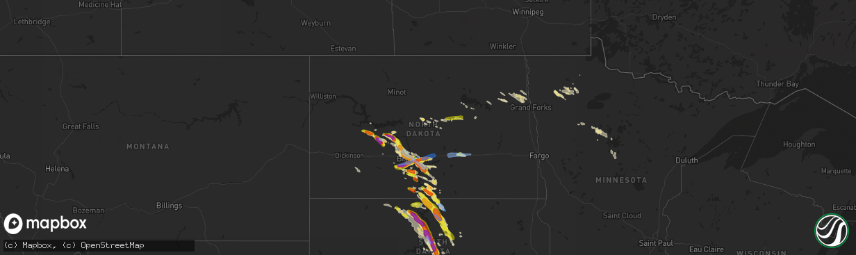
Hail Map in North Dakota on August 6, 2019
The weather event in North Dakota on August 6, 2019 includes Wind and Hail maps. 28 states and 779 cities were impacted and suffered possible damage. The total estimated number of properties impacted is 63,342.
Want more than just the map?
Turn this storm into a full workflow.
- Owner + property data so you know who to knock
- OnDemand branded weather history reports to win the "did we even have hail?" argument
- RoofTrace estimate so reps stop guessing numbers at the door
Bought this map? Upgrade within 7 days and we'll credit the $230. (10-15 min setup call)
Wind
Hail
63,342
Estimated number of impacted properties by a 1.00" hail or larger6,734
Estimated number of impacted properties by a 1.75" hail or larger0
Estimated number of impacted properties by a 2.50" hail or largerStorm reports in North Dakota
North Dakota
| Date | Description |
|---|---|
| 08/06/20196:53 PM CDT | A local report indicates 1.00 inch wind near 4 N EMRICK |
| 08/06/20196:49 PM CDT | Lots of penny size hail with largest hail size up to a quarter. |
| 08/06/20195:57 PM CDT | Measured wind gust at the north dakota agricultural weather network observation site. |
| 08/06/20195:53 PM CDT | Picture shows a large tree snapped. Tree then fell on pickup. Time estimated by radar. Relayed by media. |
| 08/06/20195:50 PM CDT | Delayed report. Lots of golf ball to 2 inch hail reported with extensive crop and building damage. 60 to 70 mph winds estimated. Time estimated from radar. |
| 08/06/20195:46 PM CDT | Still hailing at time of report. No estimate on wind speed... Just that it was very bad. |
| 08/06/20195:45 PM CDT | Picture shows large tree snapped. Time estimated by radar. Relayed by media. |
| 08/06/20195:45 PM CDT | Public report relayed by social media. Time estimated by radar. |
| 08/06/20195:34 PM CDT | Spotter estimated wind gusts up to 60 mph. Trees with 6 inch diameter trunks were being bent close to the ground... But not breaking. Accompanied by hail up to one-half |
| 08/06/20194:41 PM CDT | Quarter sized hail. |
| 08/06/20194:41 PM CDT | 72 mph wind gust. |
| 08/06/20194:39 PM CDT | Measured wind gust at sterling nd dot sensor site. |
| 08/06/20194:30 PM CDT | Quarter size to golf ball size hail reported in sterling. Large trees and power lines down. |
| 08/06/20194:25 PM CDT | Far west mandan. |
| 08/06/20194:20 PM CDT | Heavy rain. |
| 08/06/20194:17 PM CDT | A local report indicates 1.00 inch wind near 3 NW MANDAN |
| 08/06/20194:12 PM CDT | 4 west of harmon lake. |
| 08/06/20194:05 PM CDT | Strong winds reported at mcdowell dam east of bismarck. |
| 08/06/20194:04 PM CDT | A local report indicates 1.50 inch wind near 1 ENE LINCOLN |
| 08/06/20193:56 PM CDT | Lasted until 4 pm cdt. |
| 08/06/20193:47 PM CDT | A local report indicates 1.50 inch wind near 3 E CENTER |
| 08/06/20193:40 PM CDT | A local report indicates 1.00 inch wind near 6 SW HUFF |
| 08/06/20193:35 PM CDT | Crop damage also reported. |
| 08/06/20193:23 PM CDT | A local report indicates 1.00 inch wind near 9 S BEULAH |
| 08/06/20193:17 PM CDT | Estimated 60 to 70 mph winds. Egg sized hail. Portions of trees stripped of leaves. Lots of crop damage. |
| 08/06/20193:17 PM CDT | 60 to 70 mph winds. Portions of trees stripped of leaves. Lots of crop damage. |
| 08/06/20192:40 PM CDT | A local report indicates 1.00 inch wind near HAZEN |
| 08/06/20192:40 PM CDT | Lots of pea to quarter size hail... Largest stone was the size of a walnut. |
| 08/06/20192:03 AM CDT | At 703 PM CDT, a severe thunderstorm was located near Bremen, or 36 miles southwest of Devils Lake, moving east at 40 mph. HAZARD...60 mph wind gusts and half dollar size hail. SOURCE...Radar indicated. IMPACT...Hail damage to vehicles is expected. Expect wind damage to roofs, siding, and trees. This severe thunderstorm will be near... New Rockford around 715 PM CDT. Brantford around 730 PM CDT. |
| 08/06/20191:49 AM CDT | At 649 PM CDT, a severe thunderstorm was located 6 miles east of Fessenden, or 21 miles east of Harvey, moving east at 40 mph. HAZARD...60 mph wind gusts and quarter size hail. SOURCE...Radar indicated. IMPACT...Hail damage to vehicles is expected. Expect wind damage to roofs, siding, and trees. This severe thunderstorm will remain over mainly rural areas of northeastern Wells County, including the following locations... Hamberg, Emrick and Bremen. |
| 08/06/201912:34 AM CDT | At 534 PM CDT, a severe thunderstorm was located near Medina, moving east at 40 mph. HAZARD...60 mph wind gusts and penny size hail. SOURCE...Radar indicated. IMPACT...Expect damage to roofs, siding, and trees. This severe thunderstorm will be near... Cleveland around 540 PM CDT. Buchanan around 605 PM CDT. Jamestown around 610 PM CDT. Spiritwood Lake and Spiritwood around 625 PM CDT.Other locations impacted by this severe thunderstorm includeEldridge, Sydney and Windsor. |
| 08/05/201911:38 PM CDT | At 438 PM CDT, a severe thunderstorm was located near Bismarck, moving southeast at 35 mph. HAZARD...Tennis ball size hail and 70 mph wind gusts. SOURCE...Radar indicated. IMPACT...People and animals outdoors will be injured. Expect hail damage to roofs, siding, windows, and vehicles. Expect considerable tree damage. Wind damage is also likely to mobile homes, roofs, and outbuildings. This severe thunderstorm will be near... Lincoln around 445 PM CDT. Cannon Ball around 525 PM CDT.Other locations impacted by this severe thunderstorm includeMckenzie, Fort Rice, Fort Abraham Lincoln State Park, Moffit,Hazelton Recreation Area, University Of Mary, Beaver Bay RecreationArea and Huff. |
| 08/05/201911:14 PM CDT | At 414 PM CDT, a severe thunderstorm was located 5 miles west of Sterling, or 17 miles east of Bismarck, moving northeast at 35 mph. HAZARD...Ping pong ball size hail and 60 mph wind gusts. SOURCE...Radar indicated. IMPACT...People and animals outdoors will be injured. Expect hail damage to roofs, siding, windows, and vehicles. Expect wind damage to roofs, siding, and trees. This severe thunderstorm will be near... Sterling around 420 PM CDT. Steele around 450 PM CDT.Other locations impacted by this severe thunderstorm include Mckenzieand Driscoll. |
| 08/05/201910:56 PM CDT | At 355 PM CDT, a severe thunderstorm was located 9 miles southeast of Center, or 17 miles south of Washburn, moving southeast at 35 mph. HAZARD...60 mph wind gusts and half dollar size hail. SOURCE...Radar indicated. IMPACT...Hail damage to vehicles is expected. Expect wind damage to roofs, siding, and trees. This severe thunderstorm will be near... Lake Harmon around 415 PM CDT. Mandan around 420 PM CDT. Bismarck around 435 PM CDT.Other locations impacted by this severe thunderstorm include DoubleDitch Indian Village, Price, Baldwin, Crown Butte Lake, Sanger,Hensler, Nelson Lake and Fort Abraham Lincoln State Park. |
| 08/05/201910:36 PM CDT | At 335 PM CDT, a severe thunderstorm was located 9 miles north of Solen, or 19 miles south of Bismarck, moving east at 15 mph. HAZARD...Golf ball size hail and 70 mph wind gusts. SOURCE...Radar indicated. IMPACT...People and animals outdoors will be injured. Expect hail damage to roofs, siding, windows, and vehicles. Expect considerable tree damage. Wind damage is also likely to mobile homes, roofs, and outbuildings. This severe thunderstorm will remain over mainly rural areas of northeastern Sioux, southeastern Morton and northwestern Emmons Counties, including the following locations... Hazelton Recreation Area, Fort Rice and Huff. |
| 08/05/201910:30 PM CDT | At 329 PM CDT, a severe thunderstorm was located 6 miles north of St. Anthony, or 8 miles south of Mandan, moving east at 35 mph. HAZARD...70 mph wind gusts and ping pong ball size hail. SOURCE...Radar indicated. IMPACT...People and animals outdoors will be injured. Expect hail damage to roofs, siding, windows, and vehicles. Expect considerable tree damage. Wind damage is also likely to mobile homes, roofs, and outbuildings. This severe thunderstorm will be near... Bismarck and Lincoln around 350 PM CDT. Mcdowell Dam Recreation Area around 355 PM CDT. Menoken around 405 PM CDT.Other locations impacted by this severe thunderstorm includeUniversity Of Mary and Fort Abraham Lincoln State Park. |
| 08/05/201910:11 PM CDT | At 311 PM CDT, a severe thunderstorm was located near Stanton, or 15 miles east of Beulah, moving southeast at 15 mph. HAZARD...Tennis ball size hail and 60 mph wind gusts. SOURCE...Radar indicated. IMPACT...People and animals outdoors will be injured. Expect hail damage to roofs, siding, windows, and vehicles. Expect wind damage to roofs, siding, and trees. This severe thunderstorm will be near... Stanton around 315 PM CDT. Center around 350 PM CDT.Other locations impacted by this severe thunderstorm include Hensler,Falkirk and Fort Clark. |
| 08/05/201910:05 PM CDT | At 305 PM CDT, a severe thunderstorm was located near Zap, or near Beulah, moving southeast at 25 mph. HAZARD...Ping pong ball size hail and 60 mph wind gusts. SOURCE...Radar indicated. IMPACT...People and animals outdoors will be injured. Expect hail damage to roofs, siding, windows, and vehicles. Expect wind damage to roofs, siding, and trees. This severe thunderstorm will be near... Beulah around 315 PM CDT. |
| 08/05/201910:02 PM CDT | At 302 PM CDT, a severe thunderstorm was located 7 miles south of Fish Creek Dam, or 22 miles southwest of Mandan, moving east at 30 mph. HAZARD...Ping pong ball size hail and 60 mph wind gusts. SOURCE...Radar indicated. IMPACT...People and animals outdoors will be injured. Expect hail damage to roofs, siding, windows, and vehicles. Expect wind damage to roofs, siding, and trees. This severe thunderstorm will be near... St. Anthony around 330 PM CDT.Other locations impacted by this severe thunderstorm include Breien. |
| 08/05/20199:37 PM CDT | At 237 PM CDT, a severe thunderstorm was located over Hazen, or 8 miles northeast of Beulah, moving east at 20 mph. HAZARD...Ping pong ball size hail and 60 mph wind gusts. SOURCE...Radar indicated. IMPACT...People and animals outdoors will be injured. Expect hail damage to roofs, siding, windows, and vehicles. Expect wind damage to roofs, siding, and trees. This severe thunderstorm will be near... Stanton around 310 PM CDT. |
| 08/05/20199:22 PM CDT | At 222 PM CDT/122 PM MDT/, a severe thunderstorm was located 5 miles northeast of Halliday, or 22 miles northwest of Beulah, moving east at 15 mph. HAZARD...60 mph wind gusts and half dollar size hail. SOURCE...Radar indicated. IMPACT...Hail damage to vehicles is expected. Expect wind damage to roofs, siding, and trees. This severe thunderstorm will be near... Dodge around 230 PM CDT. Golden Valley around 255 PM CDT. |
| 08/05/20197:16 PM CDT | Quarter to half dollar sized hail |
All States Impacted by Hail Map on August 6, 2019
Cities Impacted by Hail Map on August 6, 2019
- Burlington, CO
- Herreid, SD
- Grand Forks, ND
- Gilby, ND
- Inkster, ND
- Manvel, ND
- Fordville, ND
- Forest River, ND
- Minto, ND
- Mekinock, ND
- Campbellsburg, IN
- Orleans, IN
- Corydon, KY
- Henderson, KY
- Cannon Ball, ND
- Newark Valley, NY
- Berkshire, NY
- Scott City, MO
- Harrison, NE
- Macedonia, IL
- Springerton, IL
- McLeansboro, IL
- Enfield, IL
- Dahlgren, IL
- Zap, ND
- Golden Valley, ND
- Hazen, ND
- Dodge, ND
- Halliday, ND
- Beulah, ND
- Dyersburg, TN
- Friendship, TN
- Minneola, KS
- Perryton, TX
- Bismarck, ND
- Stanton, ND
- Harrold, SD
- Pierre, SD
- Johnstown, NE
- Ainsworth, NE
- Long Pine, NE
- Burrton, KS
- Moundridge, KS
- Benton, KY
- Gilbertsville, KY
- Rinard, IL
- Xenia, IL
- Johnsonville, IL
- Madison, TN
- Hendersonville, TN
- Goodlettsville, TN
- Old Hickory, TN
- Greenbrier, TN
- Raleigh, IL
- Eldorado, IL
- Galatia, IL
- Broughton, IL
- Blunt, SD
- Lesterville, MO
- Centerville, MO
- Redford, MO
- Burke, SD
- Gregory, SD
- Whitewater, MO
- Chaffee, MO
- Cape Girardeau, MO
- Stonefort, IL
- Golconda, IL
- Eddyville, IL
- Herod, IL
- Jackson, MO
- Stuart, NE
- Atkinson, NE
- Naper, NE
- Halstead, KS
- Sedgwick, KS
- Hornsby, TN
- Wood Lake, NE
- Selby, SD
- Java, SD
- Holabird, SD
- Gettysburg, SD
- Onida, SD
- Eagle Butte, SD
- Trail City, SD
- Lower Brule, SD
- Wakpala, SD
- Agar, SD
- Fort Thompson, SD
- Goodridge, MN
- Grygla, MN
- Silex, MO
- Ellington, MO
- Austin, KY
- Fountain Run, KY
- Lexington, IN
- Nabb, IN
- Princeton, KY
- Sikeston, MO
- Benton, MO
- Oran, MO
- Dresden, TN
- Bassett, NE
- Burwell, NE
- Hurdsfield, ND
- Harvey, ND
- Laporte, MN
- Bemidji, MN
- Mandan, ND
- Center, ND
- New Salem, ND
- Pen Argyl, PA
- Belvidere, NJ
- Nazareth, PA
- Phillipsburg, NJ
- Bangor, PA
- Newton, KS
- Ojo Caliente, NM
- Hartford, KY
- Solen, ND
- Dawson Springs, KY
- Marion, KY
- Fredonia, KY
- Pittsburg, KS
- Girard, KS
- Cherokee, KS
- Gate, OK
- Charlotte, TN
- White Bluff, TN
- Englewood, KS
- Deposit, NY
- Hancock, NY
- Bethlehem, IN
- New Washington, IN
- Bowdle, SD
- Oberon, ND
- Backus, MN
- Pine River, MN
- Hackensack, MN
- Hillsboro, MO
- De Soto, MO
- Southside, TN
- Labadie, MO
- Laverne, OK
- Rosston, OK
- Ironton, MO
- Grand Rivers, KY
- Smithland, KY
- Nunnelly, TN
- Fairfield, IL
- New Madrid, MO
- Matthews, MO
- Bertrand, MO
- East Prairie, MO
- Mercer, TN
- Denmark, TN
- Jackson, TN
- Martinsville, IL
- Saint Albans, MO
- Villa Ridge, MO
- Dittmer, MO
- Washington, MO
- Marthasville, MO
- Robertsville, MO
- Defiance, MO
- Foristell, MO
- Saint Clair, MO
- Augusta, MO
- Lonedell, MO
- Catawissa, MO
- Gray Summit, MO
- Pacific, MO
- House Springs, MO
- Eureka, MO
- Union, MO
- Cedar Hill, MO
- Bunker, MO
- Geddes, SD
- Platte, SD
- Salem, IL
- Iuka, IL
- Patoka, IL
- Odin, IL
- Sandoval, IL
- Annapolis, MO
- Caledonia, MO
- Arcadia, MO
- Belgrade, MO
- Belleview, MO
- Middle Brook, MO
- Yuma, CO
- Sturgis, KY
- Potwin, KS
- Whitewater, KS
- Bethune, CO
- Goodrich, ND
- Alexandria, KY
- Latonia, KY
- Newport, KY
- Ft Mitchell, KY
- Independence, KY
- Jonesboro, AR
- Beech Grove, AR
- Peach Orchard, AR
- Paragould, AR
- Walnut Ridge, AR
- Delaplaine, AR
- Bono, AR
- Pocahontas, AR
- Dixon, KY
- Nebo, KY
- Slaughters, KY
- Manitou, KY
- Cleveland, ND
- Medina, ND
- Port Saint Lucie, FL
- Strasburg, ND
- Saint Paul, KS
- Wayne City, IL
- Sims, IL
- Potosi, MO
- Junction City, AR
- Newport, NE
- Linton, ND
- Highmore, SD
- Leasburg, MO
- Steelville, MO
- Nashville, TN
- Bells, TN
- Niagara, ND
- Petersburg, ND
- Crookston, NE
- Valentine, NE
- Underwood, ND
- Vandalia, IL
- Ramsey, IL
- Mulberry Grove, IL
- Shobonier, IL
- Seneca, SD
- Walnut, KS
- Erie, KS
- Booker, TX
- Pollock, SD
- Hague, ND
- Dickson, TN
- Bon Aqua, TN
- McEwen, TN
- Morganfield, KY
- Adairville, KY
- Adams, TN
- Cedar Hill, TN
- Olmstead, KY
- Springfield, TN
- Humansville, MO
- Stockton, MO
- Uniontown, KS
- Redfield, KS
- Bronson, KS
- Medon, TN
- Brownsville, TN
- Queenstown, MD
- Saint Michaels, MD
- Claiborne, MD
- Millville, DE
- Frankford, DE
- Ocean View, DE
- Watauga, SD
- Toone, TN
- Howes, SD
- White Owl, SD
- Wall, SD
- Sterling, ND
- Great Falls, VA
- Beaver Dam, KY
- Centertown, KY
- Castle Creek, NY
- Chenango Forks, NY
- Greene, NY
- Trezevant, TN
- Greenfield, TN
- McKenzie, TN
- Conneaut, OH
- Follett, TX
- Higgins, TX
- Lipscomb, TX
- Henderson, TN
- Finger, TN
- Bridgeport, IL
- Sumner, IL
- Baltimore, MD
- Kit Carson, CO
- Cadiz, KY
- Eureka, SD
- Saint Francisville, IL
- Allendale, IL
- Idalia, CO
- Kirk, CO
- Carmi, IL
- Mound City, SD
- Hornbeak, TN
- Burna, KY
- Salem, KY
- Gadsden, TN
- Poplar Bluff, MO
- Grandin, MO
- Dahlen, ND
- Denhoff, ND
- Bethesda, MD
- Washington, DC
- Chevy Chase, MD
- Corinth, MS
- Barnhill, IL
- Flora, IL
- Geff, IL
- Mill Shoals, IL
- Norris City, IL
- Keenes, IL
- Cisne, IL
- Bluford, IL
- Fort Plain, NY
- Little Falls, NY
- Cresco, PA
- Canadensis, PA
- Alton, MO
- Couch, MO
- Brentwood, TN
- Thief River Falls, MN
- Newfolden, MN
- Herrick, SD
- Mills, NE
- Naylor, MO
- Doniphan, MO
- Oxly, MO
- Moffit, ND
- Braddock, ND
- Flasher, ND
- Hazelton, ND
- Menoken, ND
- Saint Anthony, ND
- Troy, KS
- Denton, KS
- Montgomery, IN
- El Dorado Springs, MO
- Collins, MO
- Bethel Springs, TN
- Hoven, SD
- Tolstoy, SD
- Yale, IL
- Newton, IL
- Willow Hill, IL
- Wheeler, IL
- Collinwood, TN
- Waynesboro, TN
- Cassoday, KS
- Burns, KS
- Dale, IL
- Thompsonville, IL
- Harrisburg, IL
- Cadet, MO
- Mineral Point, MO
- Davisville, MO
- McLaughlin, SD
- Saint Charles, SD
- Fairfax, SD
- Pukwana, SD
- Reliance, SD
- Bonesteel, SD
- Oacoma, SD
- Chamberlain, SD
- Cynthiana, KY
- Paris, KY
- Carlisle, KY
- Eddyville, KY
- Oxford, AR
- Brockwell, AR
- Wideman, AR
- Violet Hill, AR
- Boss, MO
- Brownsville, KY
- Smiths Grove, KY
- Bowling Green, KY
- Robards, KY
- Regent, ND
- Hepler, KS
- Fort Scott, KS
- Moran, KS
- Cass Lake, MN
- Junction, IL
- Equality, IL
- Rochester, KY
- Fort Yates, ND
- Hoyt, KS
- Meriden, KS
- Falkner, MS
- Tiplersville, MS
- Butte, NE
- Sullivan, MO
- Carson, NM
- Mcclusky, ND
- Spencer, NE
- Eads, CO
- Charlestown, IN
- Otisco, IN
- Hanover, IN
- Marysville, IN
- Henryville, IN
- Westport, KY
- Underwood, IN
- Bedford, KY
- Cottontown, TN
- Whites Creek, TN
- White House, TN
- Joelton, TN
- Roseau, MN
- Salem, MO
- Centerville, TN
- Lyles, TN
- Kanorado, KS
- Mount Carmel, IL
- Huron, TN
- Cerrillos, NM
- Faulkton, SD
- Michigan, ND
- Larimore, ND
- Mountain Dale, NY
- Fairview, TN
- Byron, NE
- Blackwell, MO
- Ash Grove, MO
- Aldrich, MO
- Walnut Grove, MO
- Eckley, CO
- Park City, KY
- Cave City, KY
- Texico, IL
- Beltsville, MD
- Livermore, KY
- Primm Springs, TN
- Franklin, TN
- Ridgely, TN
- Obion, TN
- Tiptonville, TN
- Troy, TN
- Glasgow, KY
- Cedarville, OH
- Leonardville, KS
- Randolph, KS
- Versailles, IN
- Lamar, CO
- Holly, CO
- Alta Vista, KS
- Alma, KS
- Bolivar, TN
- Marsland, NE
- Conway Springs, KS
- Viola, KS
- Glencross, SD
- Hamill, SD
- Bristow, NE
- Oneill, NE
- Lynch, NE
- Kennebec, SD
- Timber Lake, SD
- Fort Campbell, KY
- Woodlawn, TN
- Indian Mound, TN
- Cumberland City, TN
- La Fayette, KY
- Big Rock, TN
- Palmyra, TN
- Ashland City, TN
- Kunkletown, PA
- Wright City, MO
- Solway, MN
- Eminence, KY
- Shelbyville, KY
- Dillsboro, IN
- Ruskin, NE
- Richwoods, MO
- Andale, KS
- Vernon, CO
- Goddard, KS
- Corning, AR
- Glenham, SD
- Everton, MO
- Torrington, WY
- Knobel, AR
- Lafayette Hill, PA
- Narberth, PA
- Philadelphia, PA
- Clarksville, TN
- Philip, SD
- Enning, SD
- Bagley, MN
- El Dorado, AR
- White Oak, GA
- Sheridan Lake, CO
- Lakota, ND
- Central City, KY
- McHenry, KY
- La Vergne, TN
- Antioch, TN
- Nolensville, TN
- Michie, TN
- Ramer, TN
- Guys, TN
- Selmer, TN
- State University, AR
- Shawnee, WY
- Holton, IN
- Osgood, IN
- Bourbon, MO
- Pilot Knob, MO
- Russellville, KY
- Dover, TN
- Tennessee Ridge, TN
- Huntingdon, TN
- Stratton, CO
- Arapahoe, CO
- Rising City, NE
- Oblong, IL
- Alliance, NE
- Ewing, IL
- Whittington, IL
- Benton, IL
- Welch, OK
- Bluejacket, OK
- Miami, OK
- Goodland, KS
- Harviell, MO
- Chambers, NE
- Effingham, IL
- Teutopolis, IL
- Westport, IN
- Greensburg, IN
- O'Fallon, MO
- Lake Saint Louis, MO
- Wentzville, MO
- Success, AR
- Gatzke, MN
- Lawrenceville, IL
- Salem, IN
- Burnsville, MS
- Glen, MS
- Garden Plain, KS
- Easton, MD
- Scammon, KS
- Carlyle, IL
- Shawneetown, IL
- Burnt Prairie, IL
- Clay, KY
- Cave In Rock, IL
- Alma, IL
- Elizabethtown, IL
- Omaha, IL
- Kinmundy, IL
- Ridgway, IL
- Belle Rive, IL
- West Frankfort, IL
- Nortonville, KY
- White Plains, KY
- Cathay, ND
- New Rockford, ND
- Reynolds Station, KY
- Fordsville, KY
- Chapmansboro, TN
- Stark, KS
- Wildersville, TN
- Gettysburg, PA
- Altamont, IL
- Fessenden, ND
- Atwood, TN
- Cedar Grove, TN
- Madisonville, KY
- Providence, KY
- Hanson, KY
- Stewart, TN
- Kintyre, ND
- Driscoll, ND
- Merriman, NE
- Beechmont, KY
- Drakesboro, KY
- Beech Creek, KY
- Belton, KY
- Browder, KY
- Humboldt, TN
- Trenton, TN
- Middleton, TN
- Walnut, MS
- Pocahontas, TN
- Amarillo, TX
- Cottage Grove, TN
- Dukedom, TN
- Palmersville, TN
- Havre, MT
- Bala Cynwyd, PA
- Glenside, PA
- Flourtown, PA
- Conshohocken, PA
- Gladwyne, PA
- Lake George, MN
- Dodge City, KS
- Sheyenne, ND
- Erin, TN
- Holladay, TN
- Westport, TN
- Lawrenceburg, TN
- Marion, IL
- Puryear, TN
- Shumway, IL
- Decker, IN
- Vincennes, IN
- Paris, TN
- Berry, KY
- Enville, TN
- Cherryville, MO
- Viburnum, MO
- Pinson, TN
- Amelia, NE
- Evansville, IN
- Patoka, IN
- Owensville, IN
- Charleston, MO
- Smithfield, KY
- Lucas, KY
- Chanute, KS
- Mount Olivet, KY
- Montrose, IL
- Kuttawa, KY
- Mound City, IL
- Mounds, IL
- Cincinnati, OH
- Dexter, MO
- Dudley, MO
- Union City, TN
- Portageville, MO
- Elbing, KS
- Scottsville, KY
- Alamo, TN
- Halls, TN
- Columbus, KS
- Bone Gap, IL
- Hopkinsville, KY
- Crofton, KY
- Newbern, TN
- Potomac, MD
- Bridgeport, NE
- Wind Gap, PA
- Caneyville, KY
- McLean, VA
- Cabin John, MD
- Glen Echo, MD
- Hillsboro, KY
- Owingsville, KY
- Holland, KY
- Bumpus Mills, TN
- Burfordville, MO
- Mount Vernon, IN
- Uniontown, KY
- Savannah, NY
- McIntosh, SD
- McCune, KS
- Essex, MO
- Bloomfield, MO
- Watson, IL
- Dieterich, IL
- Warrenton, MO
- Saint Cloud, FL
- Robinson, KS
- Hiawatha, KS
- Morgantown, KY
- Buena Vista, TN
- Lisle, NY
- Metropolis, IL
- Grantsburg, IL
- Vienna, IL
- Simpson, IL
- Glen Ullin, ND
- Carrier Mills, IL
- Green, KS
- Greenleaf, KS
- Barnes, KS
- Dundas, IL
- Burlingame, KS
- Mchenry, ND
- Kilgore, NE
- Weir, KS
- Farlington, KS
- Calhoun, KY
- Cub Run, KY
- Mammoth Cave, KY
- Mohawk, NY
- Beech Bluff, TN
- Luray, TN
- Troy, MO
- Moscow Mills, MO
- Jay Em, WY
- Miller City, IL
- Marble Hill, MO
- Thebes, IL
- Hickman, KY
- Westmoreland, KS
- Cumberland Furnace, TN
- Vanleer, TN
- Etoile, KY
- Rosiclare, IL
- Selbyville, DE
- Dagsboro, DE
- Boelus, NE
- Saint Paul, NE
- Clay Center, NE
- Cairo, NE
- Superior, NE
- Chapman, NE
- Elba, NE
- Shelton, NE
- Alda, NE
- Oak, NE
- Glenvil, NE
- Ord, NE
- Ayr, NE
- Dannebrog, NE
- Harvard, NE
- North Loup, NE
- Saint Libory, NE
- Loup City, NE
- Nelson, NE
- Webber, KS
- Elyria, NE
- Aurora, NE
- Wood River, NE
- Republic, KS
- Grand Island, NE
- Palmer, NE
- Phillips, NE
- Ashton, NE
- Blue Hill, NE
- Farwell, NE
- Giltner, NE
- Inland, NE
- Edgar, NE
- Deweese, NE
- Doniphan, NE
- Trumbull, NE
- Marquette, NE
- Juniata, NE
- Hastings, NE
- Fairfield, NE
- Hardy, NE
- Onaka, SD
- Meade, KS
- Scotia, NE
- Tappen, ND
- Jamestown, ND
- Black, MO
- Milton, KS
- Cheney, KS
- Riley, KS
- Manhattan, KS
- Wamego, KS
- Saint George, KS
- Olsburg, KS
- Emmett, KS
- Paxico, KS
- Onaga, KS
- Eskridge, KS
- Belvue, KS
- Saint Marys, KS
- McFarland, KS
- Melvern, KS
- Quenemo, KS
- Vassar, KS
- Lyndon, KS
- Lebo, KS
- Osage City, KS
- Scranton, KS
- Allen, KS
- Dundalk, MD
- Rosedale, MD


