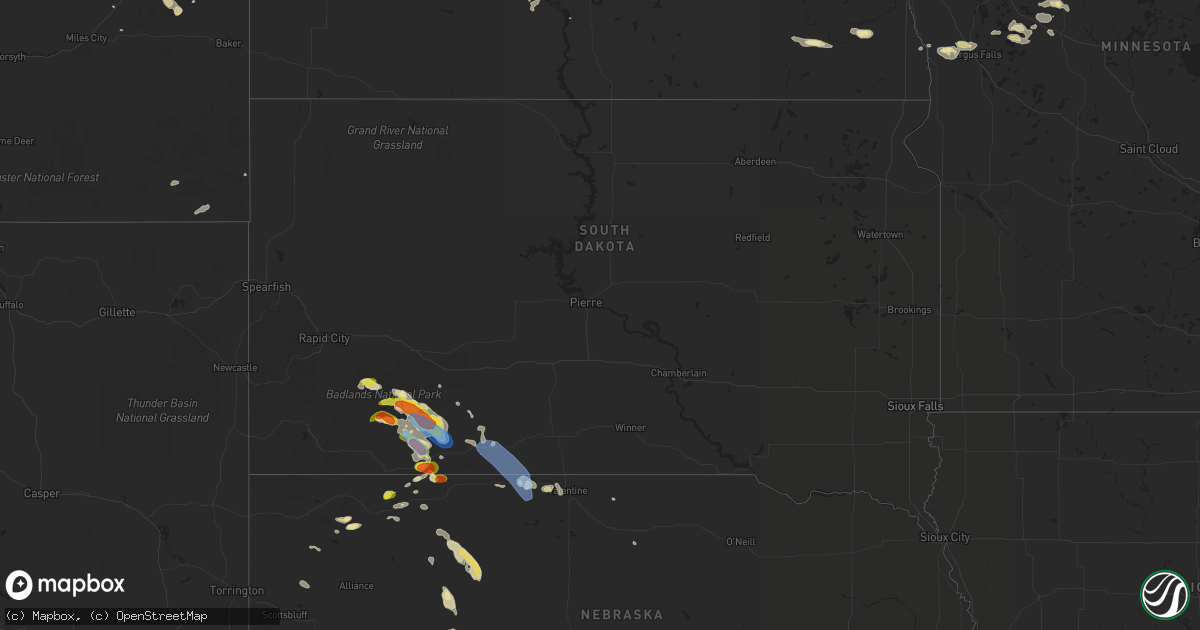
Hail Map in South Dakota on August 4, 2019
Get this storm
August 4 map
$229
one time, instant access
Download today. No call, no setup
Keep the $229
Bought the map and want the full workflow? Apply the entire $229 to a subscription within 7 days. None of it is wasted.
Every map, not just this one
This buys you this map. Subscription and you get every map we run, in the markets you choose from a few cities to whole states to nationwide. Plus real-time alerts the moment a storm fires.
Contact data
Name, contact info, occupancy, even credit band for addresses in the footprint. You go from where it hit to who to call.
Become the source they trust
Unlimited branding weather history reports on demand. You already have the documented answer ready for the property owner, and you are the one who showed up with it.
Property data and RoofTrace estimates
Pull up any address you have got, its value and the exact code rules for that jurisdiction, straight from One Click Code. Then RoofTrace estimates the squares, pitch, and roof value, priced the way you price.
Storm reports in South Dakota
South Dakota
| Date | Description |
|---|---|
| 08/04/20195:37 PM CDT | A local report indicates 60 MPH wind near 3 NNW HARRINGTON |
| 08/04/20195:30 PM CDT | A local report indicates 60 MPH wind near 4 S VETAL |
| 08/04/20194:30 PM CDT | A local report indicates 60 MPH wind near 5 E PORCUPINE |
| 08/04/20194:30 PM CDT | A local report indicates 1.75 inch wind near 5 E PORCUPINE |
| 08/04/20194:22 PM CDT | 0.91 inches of rain in about 15 minutes |
| 08/04/20194:15 PM CDT | A local report indicates 70 MPH wind near 3 ENE KYLE |
| 08/04/20194:15 PM CDT | A local report indicates 1.75 inch wind near 3 ENE KYLE |
| 08/04/20192:30 PM CDT | Very heavy rainfall |
| 08/04/20193:49 AM CDT | At 848 PM MDT, a severe thunderstorm was located 6 miles west of Osage, or 19 miles northwest of Newcastle, moving east at 35 mph. HAZARD...60 mph wind gusts and quarter size hail. SOURCE...Radar indicated. IMPACT...Hail damage to vehicles is expected. Expect wind damage to roofs, siding, and trees. Locations impacted include... Newcastle, Osage, Four Corners, Buckhorn and Mallo Camp. |
| 08/04/20191:06 AM CDT | At 606 PM CDT/506 PM MDT/, severe thunderstorms were located along a line extending from near Kilgore to near Merritt Reservoir, moving east at 60 mph. HAZARD...60 mph wind gusts and penny size hail. SOURCE...Radar indicated. IMPACT...Expect damage to roofs, siding, and trees. Locations impacted include... Valentine, Cody, Kilgore, Nenzel, Merritt Reservoir, Crookston, Wood Lake, Steer Creek Campground, Sparks, Cody Lake, Anderson Bridge State Wildlife Management Area, Smith Falls State Park, Schlagel Creek State Wildlife Management Area, Highway 97 crossing the Niobrara River and Big Alkali Lake State Wildlife Management Area.This includes the following highways... Highway 20 between mile markers 154 and 222. Highway 97 between mile markers 114 and 141. Highway 83 between mile markers 189 and 221. Highway 12 between mile markers 1 and 20. |
| 08/03/201910:13 PM CDT | At 312 PM MDT, a severe thunderstorm was located near Kyle, or 27 miles northwest of Martin, moving southeast at 35 mph. HAZARD...60 mph wind gusts and quarter size hail. SOURCE...Radar indicated. IMPACT...Hail damage to vehicles is expected. Expect wind damage to roofs, siding, and trees. Locations impacted include... Martin, Porcupine, Kyle, Allen, Wounded Knee, Batesland, Tuthill, Hisle, Harrington, Swett, Sharps Corner, Vetal, Eagle Nest Butte, Snake Butte and Lacreek Wildlife Refuge. |
| 08/03/20199:38 PM CDT | At 237 PM MDT, severe thunderstorms were located along a line extending from Badlands National Park to 9 miles southeast of Sheep Mountain Table to 8 miles southwest of Rockyford, moving east at 30 mph. HAZARD...60 mph wind gusts and quarter size hail. SOURCE...Radar indicated. IMPACT...Hail damage to vehicles is expected. Expect wind damage to roofs, siding, and trees. Locations impacted include... Kyle, Wall, Potato Creek, Interior, Scenic, Quinn, Cactus Flat, Cedar Pass, Rockyford, Folsom, Cottonwood, Sheep Mountain Table, Delta 9 Missile Silo, Minuteman Missile Visitors Center, Pinnacles Ranger Station, Delta 1 Launch Facility, Badlands National Park and Snake Butte.This includes Interstate 90 in South Dakota between Mile Markers 109and 132. |
| 08/03/20198:52 PM CDT | At 152 PM MDT, a severe thunderstorm was located 12 miles south of Batesland, or 13 miles northeast of Gordon, moving southeast at 15 mph. HAZARD...Golf ball size hail and 60 mph wind gusts. SOURCE...Radar indicated. IMPACT...People and animals outdoors will be injured. Expect hail damage to roofs, siding, windows, and vehicles. Expect wind damage to roofs, siding, and trees. Locations impacted include... Irwin, Intersection of Highway 20 and Irwin Road, Shell Lake State Wildlife Management Area and Bayonne.This includes Highway 20 between mile markers 114 and 129. |
| 08/03/20198:12 PM CDT | At 111 PM MDT, a severe thunderstorm was located 7 miles south of Batesland, or 16 miles north of Gordon, moving southeast at 15 mph. HAZARD...60 mph wind gusts and quarter size hail. SOURCE...Radar indicated. IMPACT...Hail damage to vehicles is expected. Expect wind damage to roofs, siding, and trees. Locations impacted include... Batesland. |
All States Impacted by Hail Map on August 4, 2019
Cities Impacted by Hail Map on August 4, 2019
- Ray, ND
- Epping, ND
- Alamo, ND
- Grassy Butte, ND
- Surrey, ND
- Burlington, ND
- Minot, ND
- Norwich, ND
- Berthold, ND
- Carpio, ND
- Velva, ND
- Leonard, ND
- Mcleod, ND
- Sidney, MT
- Pine Ridge, SD
- Kyle, SD
- Terry, MT
- Froid, MT
- Crookston, NE
- Houston, AL
- Double Springs, AL
- Longville, LA
- Dequincy, LA
- Philadelphia, MS
- Mandan, ND
- Chadron, NE
- Harvey, ND
- Maddock, ND
- Cook, MN
- Alzada, MT
- Waynesboro, MS
- Buckatunna, MS
- Rushville, NE
- Kilgore, NE
- Nettleton, MS
- Batesland, SD
- Fallon, MT
- Wanblee, SD
- Allen, SD
- Palermo, ND
- Stanley, ND
- Byhalia, MS
- Crossville, AL
- Dawson, AL
- Bay Springs, MS
- La Pine, OR
- Des Lacs, ND
- Martin, ND
- Max, ND
- Coleharbor, ND
- Benedict, ND
- Turtle Lake, ND
- Mercer, ND
- Ryder, ND
- Garrison, ND
- Douglas, ND
- Menahga, MN
- Ellsworth, NE
- Tetonia, ID
- Felt, ID
- Powers Lake, ND
- Anamoose, ND
- Porcupine, SD
- Vinemont, AL
- Hitterdal, MN
- De Kalb, MS
- Breckenridge, MN
- La Grande, OR
- Marion, ND
- Butte, ND
- Crofton, KY
- Hopkinsville, KY
- Eva, AL
- Joppa, AL
- Baileyton, AL
- Killdeer, ND
- Dunn Center, ND
- Fairfield, ND
- Valentine, NE
- Lowndesboro, AL
- Ross, ND
- Pocatello, ID
- Arbon, ID
- Martin, SD
- Aberdeen, MS
- Geraldine, AL
- Carthage, MS
- Richardton, ND
- Tioga, ND
- Sebeka, MN
- New York Mills, MN
- Crane Lake, MN
- Robinson, ND
- Tuttle, ND
- Pike Road, AL
- Mathews, AL
- Montgomery, AL
- Ramer, AL
- Bladenboro, NC
- Fort Ransom, ND
- Gordon, NE
- Park Rapids, MN
- Glenburn, ND
- Bantry, ND
- Deering, ND
- Berlin, MD
- Whaleyville, MD
- Willards, MD
- Pittsville, MD
- Taylorsville, NC
- Granite Falls, NC
- Merriman, NE
- Hyannis, NE
- Ashby, NE
- Voltaire, ND
- Ruso, ND
- Mcclusky, ND
- Ottertail, MN
- Richville, MN
- Whitman, NE
- Hackensack, MN
- Grady, AL
- Foxhome, MN
- Fergus Falls, MN
- Sawyer, ND
- Escalante, UT
- Keystone, NE
- Prairie City, OR
- Douglas, WY
- Lisbon, ND
- Addison, AL
- Upton, WY
- Centreville, AL
- Erhard, MN
- Dent, MN
- Underwood, MN
- Irwin, ID
- Fessenden, ND
- Wheatland, ND
- Fingal, ND
- Pontotoc, MS
- Evergreen, AL
- Repton, AL
- Monroeville, AL
- Halliday, ND
- Hawley, MN
- Lake Park, MN
- Vardaman, MS
- Houston, MS
- Houlka, MS
- Goodman, MS
- Durant, MS
- Granville, ND
- Beulah, ND
- Golden Valley, ND
- Rockfield, KY
- Morgantown, KY
- Auburn, KY
- Hay Springs, NE
- Big Falls, MN
- Orr, MN
- Hayneville, AL
- Tyler, AL
- Bowdon, ND
- Manning, ND
- Glendive, MT
- Newcastle, WY
- Osage, WY
- Williston, ND
- Cleveland, MS
- Prattville, AL
- Hermosa, SD
- Lexington, MS
- Prairie, MS
- Calhoun City, MS
- Fyffe, AL
- Arthur, NE
- Highland Home, AL
- Goshen, AL
- Okolona, MS
- Inverness, MS
- Westpoint, TN
- Elizabethtown, NC
- Akron, AL
- Moundville, AL
- Greensboro, AL
- Gore Springs, MS
- Duck Hill, MS
- Lemoyne, NE
- Detroit Lakes, MN
- Ocean City, MD
- Fenwick Island, DE
- Selbyville, DE
- Ulen, MN
- Adamsville, TN
- Fort Laramie, WY
- Nevis, MN
- Falkville, AL
- Cullman, AL
- Sulligent, AL
- Lewellen, NE
- Indianola, MS
- Isola, MS
- White Earth, ND
- Lambert, MT
- Taylor, ND
- Hebron, ND
- Luverne, AL
- Buchanan, ND
- Yuma, CO
- Cartwright, ND
- Saint Anthony, ND
- Wheatland, WY
- Peerless, MT
- Wolf Point, MT
- Sumpter, OR
- Plaza, ND
- Russellville, AL
- Leighton, AL
- Harwood, ND
- Rockford, AL
- Hazelton, ND
- Kenmare, ND
- Glen Ullin, ND
- Makoti, ND
- Roseglen, ND
- Union, MS
- Hudson, NC
- West Point, MS
- Preston, MS
- Battle Lake, MN
- Henning, MN
- Perham, MN
- Springview, NE
- Cathay, ND
- New Rockford, ND
- Grenada, MS
- Frankford, DE
- Millville, DE
- Dagsboro, DE
- Ocean View, DE
- Wadena, MN
- Gladstone, ND
- Wildrose, ND
- Winona, MS
- Holcomb, MS
- Wahpeton, ND
- Minter, AL
- Coffeeville, AL
- Akeley, MN
- Millry, AL
- Auburn, AL
- Opelika, AL
- Shelly, MN
- Callaway, MN
- Audubon, MN
- Georgetown, MN
- Cody, NE
- Dickinson, ND
- Finger, TN
- Iuka, MS
- Vernon, AL
- Millsboro, DE
- Hartville, WY
- Elizabeth, MN
- Donnybrook, ND
- Collierville, TN
- Rossville, TN
- Big Creek, MS
- Brentwood, TN
- Franklin, TN
- Lawrenceburg, TN
- Sardis, AL
- La Vergne, TN
- Antioch, TN
- Nolensville, TN
- Marsland, NE
- Alliance, NE
- Hurdsfield, ND
- Orrville, AL
- Borup, MN
- Mandaree, ND
- New Town, ND
- Bluffton, MN
- Rochert, MN
- Ismay, MT
- Pittsboro, MS
- Poplar, MT
- Hornbrook, CA
- Gordo, AL
- Reform, AL
- Beach, ND
- Hammond, MT
- Boyes, MT
- Arlington, TN
- Nortonville, KY
- Leland, MS
- Backus, MN
- Wibaux, MT
- Rugby, ND
- Hickory, NC
- Clinton, TN
- Oak Ridge, TN
- Oliver Springs, TN
- Bowling Green, KY
- Cummings, ND
- Hemingford, NE
- Jemison, AL
- Enville, TN
- Henderson, TN
- Norfolk, VA
- Carrollton, AL
- Pingree, ND
- Kensal, ND
- Richland, MT
- Finley, ND
- Peterman, AL
- Verona, ND
- Ashland, OR
- Interior, SD
- Evergreen, NC
- Chadbourn, NC
- Ainsworth, NE
- Columbus, MS
- Caledonia, MS
- Alexander, ND
- Autaugaville, AL
- Drake, ND
- Attleboro, MA
- Rehoboth, MA
- North Attleboro, MA
- Attleboro Falls, MA
- Berkley, MA
- Dighton, MA
- North Dighton, MA
- Somerset, MA
- Taunton, MA
- Swansea, MA
- Assonet, MA
- Fall River, MA
- Ogallala, NE
- Brule, NE
- Paxton, NE
- Saint Francis, SD
- Nenzel, NE
- Tuthill, SD


