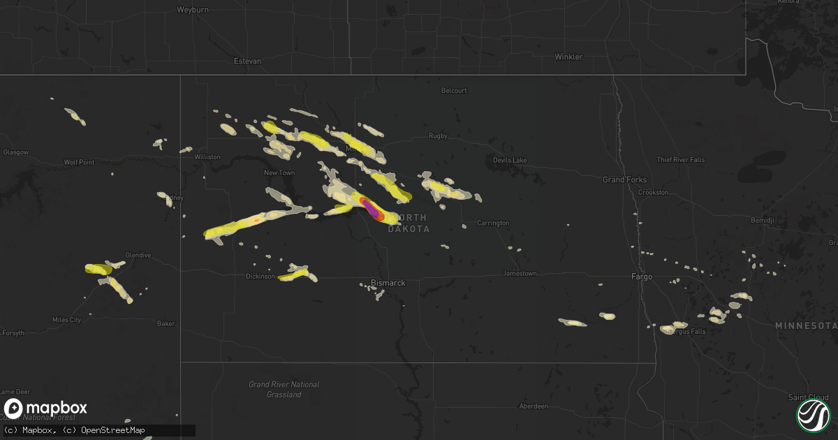
Hail Map in North Dakota on August 4, 2019
Get this storm
August 4 map
$229
one time, instant access
Download today. No call, no setup
Keep the $229
Bought the map and want the full workflow? Apply the entire $229 to a subscription within 7 days. None of it is wasted.
Every map, not just this one
This buys you this map. Subscription and you get every map we run, in the markets you choose from a few cities to whole states to nationwide. Plus real-time alerts the moment a storm fires.
Contact data
Name, contact info, occupancy, even credit band for addresses in the footprint. You go from where it hit to who to call.
Become the source they trust
Unlimited branding weather history reports on demand. You already have the documented answer ready for the property owner, and you are the one who showed up with it.
Property data and RoofTrace estimates
Pull up any address you have got, its value and the exact code rules for that jurisdiction, straight from One Click Code. Then RoofTrace estimates the squares, pitch, and roof value, priced the way you price.
Storm reports in North Dakota
North Dakota
| Date | Description |
|---|---|
| 08/04/201911:10 AM CDT | 50 - 60 mph winds accompanied the hail. |
| 08/04/20196:38 AM CDT | At 1138 PM CDT/1038 PM MDT/, a severe thunderstorm was located 6 miles southwest of Little Missouri State Park, or 11 miles northwest of Killdeer, moving northeast at 30 mph. HAZARD...Ping pong ball size hail and 60 mph wind gusts. SOURCE...Radar indicated. IMPACT...People and animals outdoors will be injured. Expect hail damage to roofs, siding, windows, and vehicles. Expect wind damage to roofs, siding, and trees. This severe thunderstorm will be near... Little Missouri State Park around 1050 PM MDT. Mckenzie Bay Recreation Area around 1220 AM CDT.Other locations impacted by this severe thunderstorm include TwinButtes, Oakdale and Skunk Creek Bay Recreation Area. |
| 08/04/20196:34 AM CDT | At 1133 PM CDT, a severe thunderstorm was located 5 miles southwest of Palermo, or 6 miles southeast of Stanley, moving southeast at 30 mph. HAZARD...60 mph wind gusts and half dollar size hail. SOURCE...Trained weather spotters. IMPACT...Hail damage to vehicles is expected. Expect wind damage to roofs, siding, and trees. This severe thunderstorm will remain over mainly rural areas of south central Ward and eastern Mountrail Counties. |
| 08/04/20196:25 AM CDT | At 1125 PM CDT, a severe thunderstorm was located 6 miles east of Blaisdell, or 20 miles east of Stanley, moving southeast at 35 mph. HAZARD...60 mph wind gusts and half dollar size hail. SOURCE...Radar indicated. IMPACT...Hail damage to vehicles is expected. Expect wind damage to roofs, siding, and trees. This severe thunderstorm will be near... Berthold around 1140 PM CDT. Des Lacs around 1155 PM CDT.Other locations impacted by this severe thunderstorm include Hartlandand Tagus. |
| 08/04/20196:17 AM CDT | At 1117 PM CDT, a severe thunderstorm was located near Denbigh, or 25 miles west of Rugby, moving southeast at 25 mph. HAZARD...60 mph wind gusts. SOURCE...Radar indicated. IMPACT...Expect damage to roofs, siding, and trees. This severe thunderstorm will remain over mainly rural areas of east central McHenry County, including the following locations... Berwick and George Lake. |
| 08/04/20196:05 AM CDT | At 1105 AM CDT/1005 AM MDT/, a severe thunderstorm was located 5 miles east of Richardton, or 18 miles west of Glen Ullin, moving east at 50 mph. HAZARD...60 mph wind gusts and quarter size hail. SOURCE...Radar indicated. IMPACT...Hail damage to vehicles is expected. Expect wind damage to roofs, siding, and trees. This severe thunderstorm will be near... Hebron around 1115 AM CDT. |
| 08/04/20196:00 AM CDT | At 1100 PM CDT, a severe thunderstorm was located over Surrey, or 5 miles east of Minot, moving southeast at 35 mph. HAZARD...70 mph wind gusts and half dollar size hail. SOURCE...Radar indicated. IMPACT...Hail damage to vehicles is expected. Expect considerable tree damage. Wind damage is also likely to mobile homes, roofs, and outbuildings. Locations impacted include... Minot, Velva, Surrey, Sawyer, Granville, Karlsruhe, Norwich, Voltaire, Logan, Bergen and Simcoe. |
| 08/04/20195:48 AM CDT | At 1048 PM CDT/948 PM MDT/, a severe thunderstorm was located 14 miles east of Trotters, or 33 miles southwest of Watford City, moving northeast at 35 mph. HAZARD...60 mph wind gusts and half dollar size hail. SOURCE...Radar indicated. IMPACT...Hail damage to vehicles is expected. Expect wind damage to roofs, siding, and trees. This severe thunderstorm will be near... Grassy Butte around 1015 PM MDT. Theodore Roosevelt National Park North Unit around 1030 PM MDT.Other locations impacted by this severe thunderstorm include Oakdale. |
| 08/04/20195:40 AM CDT | Large branches blown down around town. A crazy wind blew for several minutes. |
| 08/04/20195:30 AM CDT | A few large 4 to 6 inch diamter tree branches were blown down. Winds estimated to 60 mph. |
| 08/04/20192:35 AM CDT | Crop damage from wind driven hail. Report from august 5th. |
| 08/04/20191:30 AM CDT | 0.64 inches of rain. |
| 08/04/20191:29 AM CDT | A local report indicates 64 MPH wind near TURTLE LAKE |
| 08/04/20191:15 AM CDT | Lots of nickel to quarter sized hail. Lots of tree and crop damage. |
| 08/04/20191:00 AM CDT | Late report relayed by broadcast media. |
| 08/03/201911:45 PM CDT | A local report indicates 1.00 inch wind near 4 NNE OAKDALE |
| 08/03/201911:45 PM CDT | A local report indicates 1.00 inch wind near 6 NE OAKDALE |
| 08/03/201911:40 PM CDT | Arb 4590. |
| 08/03/201911:28 PM CDT | A local report indicates 1.25 inch wind near STANLEY |
| 08/03/201911:10 PM CDT | A local report indicates 1.00 inch wind near 1 N GRASSY BUTTE |
| 08/03/201911:00 PM CDT | Some half dollar hail. Most was dime sized. 0.63 inches of rain. |
| 08/03/201911:00 PM CDT | Report from social media. Wind was accompanied by pea size hail and heavy rain. |
| 08/03/201910:58 PM CDT | A local report indicates 70 MPH wind near 2 NNE MINOT |
All States Impacted by Hail Map on August 4, 2019
Cities Impacted by Hail Map on August 4, 2019
- Ray, ND
- Epping, ND
- Alamo, ND
- Grassy Butte, ND
- Surrey, ND
- Burlington, ND
- Minot, ND
- Norwich, ND
- Berthold, ND
- Carpio, ND
- Velva, ND
- Leonard, ND
- Mcleod, ND
- Sidney, MT
- Pine Ridge, SD
- Kyle, SD
- Terry, MT
- Froid, MT
- Crookston, NE
- Houston, AL
- Double Springs, AL
- Longville, LA
- Dequincy, LA
- Philadelphia, MS
- Mandan, ND
- Chadron, NE
- Harvey, ND
- Maddock, ND
- Cook, MN
- Alzada, MT
- Waynesboro, MS
- Buckatunna, MS
- Rushville, NE
- Kilgore, NE
- Nettleton, MS
- Batesland, SD
- Fallon, MT
- Wanblee, SD
- Allen, SD
- Palermo, ND
- Stanley, ND
- Byhalia, MS
- Crossville, AL
- Dawson, AL
- Bay Springs, MS
- La Pine, OR
- Des Lacs, ND
- Martin, ND
- Max, ND
- Coleharbor, ND
- Benedict, ND
- Turtle Lake, ND
- Mercer, ND
- Ryder, ND
- Garrison, ND
- Douglas, ND
- Menahga, MN
- Ellsworth, NE
- Tetonia, ID
- Felt, ID
- Powers Lake, ND
- Anamoose, ND
- Porcupine, SD
- Vinemont, AL
- Hitterdal, MN
- De Kalb, MS
- Breckenridge, MN
- La Grande, OR
- Marion, ND
- Butte, ND
- Crofton, KY
- Hopkinsville, KY
- Eva, AL
- Joppa, AL
- Baileyton, AL
- Killdeer, ND
- Dunn Center, ND
- Fairfield, ND
- Valentine, NE
- Lowndesboro, AL
- Ross, ND
- Pocatello, ID
- Arbon, ID
- Martin, SD
- Aberdeen, MS
- Geraldine, AL
- Carthage, MS
- Richardton, ND
- Tioga, ND
- Sebeka, MN
- New York Mills, MN
- Crane Lake, MN
- Robinson, ND
- Tuttle, ND
- Pike Road, AL
- Mathews, AL
- Montgomery, AL
- Ramer, AL
- Bladenboro, NC
- Fort Ransom, ND
- Gordon, NE
- Park Rapids, MN
- Glenburn, ND
- Bantry, ND
- Deering, ND
- Berlin, MD
- Whaleyville, MD
- Willards, MD
- Pittsville, MD
- Taylorsville, NC
- Granite Falls, NC
- Merriman, NE
- Hyannis, NE
- Ashby, NE
- Voltaire, ND
- Ruso, ND
- Mcclusky, ND
- Ottertail, MN
- Richville, MN
- Whitman, NE
- Hackensack, MN
- Grady, AL
- Foxhome, MN
- Fergus Falls, MN
- Sawyer, ND
- Escalante, UT
- Keystone, NE
- Prairie City, OR
- Douglas, WY
- Lisbon, ND
- Addison, AL
- Upton, WY
- Centreville, AL
- Erhard, MN
- Dent, MN
- Underwood, MN
- Irwin, ID
- Fessenden, ND
- Wheatland, ND
- Fingal, ND
- Pontotoc, MS
- Evergreen, AL
- Repton, AL
- Monroeville, AL
- Halliday, ND
- Hawley, MN
- Lake Park, MN
- Vardaman, MS
- Houston, MS
- Houlka, MS
- Goodman, MS
- Durant, MS
- Granville, ND
- Beulah, ND
- Golden Valley, ND
- Rockfield, KY
- Morgantown, KY
- Auburn, KY
- Hay Springs, NE
- Big Falls, MN
- Orr, MN
- Hayneville, AL
- Tyler, AL
- Bowdon, ND
- Manning, ND
- Glendive, MT
- Newcastle, WY
- Osage, WY
- Williston, ND
- Cleveland, MS
- Prattville, AL
- Hermosa, SD
- Lexington, MS
- Prairie, MS
- Calhoun City, MS
- Fyffe, AL
- Arthur, NE
- Highland Home, AL
- Goshen, AL
- Okolona, MS
- Inverness, MS
- Westpoint, TN
- Elizabethtown, NC
- Akron, AL
- Moundville, AL
- Greensboro, AL
- Gore Springs, MS
- Duck Hill, MS
- Lemoyne, NE
- Detroit Lakes, MN
- Ocean City, MD
- Fenwick Island, DE
- Selbyville, DE
- Ulen, MN
- Adamsville, TN
- Fort Laramie, WY
- Nevis, MN
- Falkville, AL
- Cullman, AL
- Sulligent, AL
- Lewellen, NE
- Indianola, MS
- Isola, MS
- White Earth, ND
- Lambert, MT
- Taylor, ND
- Hebron, ND
- Luverne, AL
- Buchanan, ND
- Yuma, CO
- Cartwright, ND
- Saint Anthony, ND
- Wheatland, WY
- Peerless, MT
- Wolf Point, MT
- Sumpter, OR
- Plaza, ND
- Russellville, AL
- Leighton, AL
- Harwood, ND
- Rockford, AL
- Hazelton, ND
- Kenmare, ND
- Glen Ullin, ND
- Makoti, ND
- Roseglen, ND
- Union, MS
- Hudson, NC
- West Point, MS
- Preston, MS
- Battle Lake, MN
- Henning, MN
- Perham, MN
- Springview, NE
- Cathay, ND
- New Rockford, ND
- Grenada, MS
- Frankford, DE
- Millville, DE
- Dagsboro, DE
- Ocean View, DE
- Wadena, MN
- Gladstone, ND
- Wildrose, ND
- Winona, MS
- Holcomb, MS
- Wahpeton, ND
- Minter, AL
- Coffeeville, AL
- Akeley, MN
- Millry, AL
- Auburn, AL
- Opelika, AL
- Shelly, MN
- Callaway, MN
- Audubon, MN
- Georgetown, MN
- Cody, NE
- Dickinson, ND
- Finger, TN
- Iuka, MS
- Vernon, AL
- Millsboro, DE
- Hartville, WY
- Elizabeth, MN
- Donnybrook, ND
- Collierville, TN
- Rossville, TN
- Big Creek, MS
- Brentwood, TN
- Franklin, TN
- Lawrenceburg, TN
- Sardis, AL
- La Vergne, TN
- Antioch, TN
- Nolensville, TN
- Marsland, NE
- Alliance, NE
- Hurdsfield, ND
- Orrville, AL
- Borup, MN
- Mandaree, ND
- New Town, ND
- Bluffton, MN
- Rochert, MN
- Ismay, MT
- Pittsboro, MS
- Poplar, MT
- Hornbrook, CA
- Gordo, AL
- Reform, AL
- Beach, ND
- Hammond, MT
- Boyes, MT
- Arlington, TN
- Nortonville, KY
- Leland, MS
- Backus, MN
- Wibaux, MT
- Rugby, ND
- Hickory, NC
- Clinton, TN
- Oak Ridge, TN
- Oliver Springs, TN
- Bowling Green, KY
- Cummings, ND
- Hemingford, NE
- Jemison, AL
- Enville, TN
- Henderson, TN
- Norfolk, VA
- Carrollton, AL
- Pingree, ND
- Kensal, ND
- Richland, MT
- Finley, ND
- Peterman, AL
- Verona, ND
- Ashland, OR
- Interior, SD
- Evergreen, NC
- Chadbourn, NC
- Ainsworth, NE
- Columbus, MS
- Caledonia, MS
- Alexander, ND
- Autaugaville, AL
- Drake, ND
- Attleboro, MA
- Rehoboth, MA
- North Attleboro, MA
- Attleboro Falls, MA
- Berkley, MA
- Dighton, MA
- North Dighton, MA
- Somerset, MA
- Taunton, MA
- Swansea, MA
- Assonet, MA
- Fall River, MA
- Ogallala, NE
- Brule, NE
- Paxton, NE
- Saint Francis, SD
- Nenzel, NE
- Tuthill, SD


