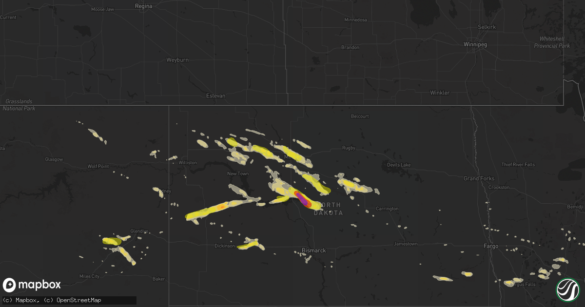
Hail Map on August 4, 2019
Get this storm
August 4 map
$229
one time, instant access
Download today. No call, no setup
Keep the $229
Bought the map and want the full workflow? Apply the entire $229 to a subscription within 7 days. None of it is wasted.
Every map, not just this one
This buys you this map. Subscription and you get every map we run, in the markets you choose from a few cities to whole states to nationwide. Plus real-time alerts the moment a storm fires.
Contact data
Name, contact info, occupancy, even credit band for addresses in the footprint. You go from where it hit to who to call.
Become the source they trust
Unlimited branding weather history reports on demand. You already have the documented answer ready for the property owner, and you are the one who showed up with it.
Property data and RoofTrace estimates
Pull up any address you have got, its value and the exact code rules for that jurisdiction, straight from One Click Code. Then RoofTrace estimates the squares, pitch, and roof value, priced the way you price.
States Impacted by Hail Map on August 4, 2019
Storm reports
Idaho
| Date | Description |
|---|---|
| 08/04/20192:47 AM CDT | At 744 PM MDT, a severe thunderstorm was located over Felt, moving northeast at 25 mph. HAZARD...Quarter size hail. SOURCE...Radar indicated. IMPACT...Damage to vehicles is expected. Locations impacted include... Felt, Tetonia and Tetonia Research Station. |
Virginia
| Date | Description |
|---|---|
| 08/04/20193:42 PM CDT | Tree knocked down in the roland park neighborhood. Report via twitter... Time estimated from radar. |
| 08/04/20193:34 PM CDT | Tree knocked down along north mallory. Time estimated from radar. |
| 08/04/20193:34 PM CDT | Power pole knocked down. Time estimated from radar. |
| 08/04/201912:04 AM CDT | At 503 PM EDT, severe thunderstorms were located along a line extending from 6 miles northwest of Virginia Beach to near Kempsville to Chesapeake, moving east at 20 mph. HAZARD...60 mph wind gusts. SOURCE...Radar indicated. IMPACT...Expect damage to trees and powerlines. Locations impacted include... Virginia Beach, Regent University, Great Bridge, Kempsville, Chesapeake, Back Bay, Fentress, Princess Anne, Rudee Heights, Princess Anne Plaza, Sigma, Pungo, Greenbrier, Bayside, Dam Neck, Hickory, Mount Pleasant, Sandbridge Beach, Herberts Corner and Oceana NAS. |
| 08/03/201911:30 PM CDT | At 430 PM EDT, severe thunderstorms were located along a line extending from near Grand View to near Northampton to near Driver, moving east at 15 mph. HAZARD...60 mph wind gusts. SOURCE...Radar indicated. IMPACT...Expect damage to trees and powerlines. Severe thunderstorms will be near, Hampton and Langley AFB around 435 PM EDT. Grand View and Buckroe Beach around 440 PM EDT. Hampton University around 445 PM EDT. Portsmouth and Fort Monroe around 450 PM EDT. Old Dominion University and Norfolk NAS around 500 PM EDT. Churchland and Ghent around 505 PM EDT. Ocean View, Downtown Norfolk, Chesapeake, Western Branch and Bowers Hill around 510 PM EDT. Virginia Wesleyan University, Deep Creek, Norfolk State University, Downtown Portsmouth, Regent University, Norfolk, Norview, Norfolk International and Cradock around 515 PM EDT.Other locations impacted by these severe thunderstorms include SouthNorfolk, Fox Hill, Portlock, Carrollton, Phoebus, Langley View,Longview, Benns Church, Huntersville and Wills Corner. |
Oregon
| Date | Description |
|---|---|
| 08/04/20191:28 AM CDT | At 627 PM PDT, a severe thunderstorm was located over Hilt, or 13 miles south of Ashland, and is nearly stationary. HAZARD...60 mph wind gusts. Tornado possible. SOURCE...Radar indicated. IMPACT...Expect damage to roofs, siding, and trees. Locations impacted include... I 5 Siskiyou Summit and Hilt. This includes Interstate 5 in Oregon between mile markers 1 and 4. |
| 08/04/201912:08 AM CDT | At 507 PM PDT, a severe thunderstorm was located 10 miles west of Sunriver, or 18 miles southwest of Bend, moving northeast at 25 mph. HAZARD...Half dollar size hail. SOURCE...Trained weather spotters. IMPACT...Damage to vehicles is expected. This severe thunderstorm will remain over mainly rural areas of southwestern Deschutes County. |
| 08/03/201911:47 PM CDT | At 446 PM PDT, a severe thunderstorm was located over Digit Point Campground At Miller Lake, or 23 miles northeast of Crater Lake, moving northeast at 10 mph. HAZARD...Quarter size hail. SOURCE...Radar indicated. IMPACT...Damage to vehicles is expected. Locations impacted include... Digit Point Campground At Miller Lake. |
| 08/03/201911:16 PM CDT | At 415 PM PDT, a severe thunderstorm was located near Digit Point Campground At Miller Lake, or 19 miles north of Crater Lake, moving northeast at 10 mph. HAZARD...Quarter size hail. SOURCE...Radar indicated. IMPACT...Damage to vehicles is expected. Locations impacted include... Digit Point Campground At Miller Lake.This includes Highway 138 in Oregon between mile markers 94 and 95. |
| 08/03/20197:06 PM CDT | Public on east side of crane prairie reservoir reported up to 1 1/2 inch hail. |
North Carolina
| Date | Description |
|---|---|
| 08/04/20194:19 PM CDT | Report of large tree blocking roadway at the intersection of tallent rd and northbrook iii school rd. Time estimated by radar. |
| 08/04/201912:44 AM CDT | At 543 PM EDT, severe thunderstorms were located along a line extending from Princess Anne to Back Bay to near Northwest, moving southeast at 15 mph. HAZARD...60 mph wind gusts. SOURCE...Radar indicated. IMPACT...Expect damage to trees and powerlines. Locations impacted include... Virginia Beach, Princess Anne, Back Bay, Sigma, Sandbridge Beach, Munden and Pungo. |
| 08/04/201912:26 AM CDT | At 525 PM EDT, a severe thunderstorm was located 7 miles southwest of Taylorsville, or near Bethlehem, moving southeast at 10 mph. HAZARD...60 mph wind gusts and quarter size hail. SOURCE...Radar indicated. IMPACT...Minor hail damage to vehicles is expected. Expect wind damage to trees and power lines. Locations impacted include... Taylorsville, St. Stephens, Conover, Bethlehem, Stony Point, Claremont, Lake Hickory, Lookout Shoals Lake, Hiddenite and Northlakes. |
| 08/04/201912:06 AM CDT | At 506 PM EDT, a severe thunderstorm was located 7 miles southeast of Lenoir, or near Granite Falls, moving southeast at 5 mph. HAZARD...60 mph wind gusts and quarter size hail. SOURCE...Radar indicated. IMPACT...Minor hail damage to vehicles is expected. Expect wind damage to trees and power lines. Locations impacted include... Hickory, St. Stephens, Longview, Sawmills, Granite Falls, Hudson, Icard, Hildebran, Connelly Springs and Rhodhiss. |
Tennessee
| Date | Description |
|---|---|
| 08/04/20193:32 PM CDT | Tree down at intersection of liberty hills drive and logan circle |
Wyoming
| Date | Description |
|---|---|
| 08/04/20193:56 AM CDT | At 854 PM MDT, a severe thunderstorm was located 13 miles north of Glendo, or 19 miles east of Douglas, moving southeast at 25 mph. HAZARD...60 mph wind gusts and penny size hail. SOURCE...Radar indicated. IMPACT...Expect damage to roofs, siding, and trees. Locations impacted include... Glendo, Sibley Peak, Glendo Reservoir, Two Moon Campground and Lost Springs.This includes Interstate 25 in Wyoming between mile markers 106 and125. |
| 08/04/20193:18 AM CDT | At 818 PM MDT, a severe thunderstorm was located 8 miles north of Douglas, moving southeast at 20 mph. HAZARD...60 mph wind gusts and quarter size hail. SOURCE...Radar indicated. IMPACT...Hail damage to vehicles is expected. Expect wind damage to roofs, siding, and trees. Locations impacted include... Douglas and Lost Springs. This includes Interstate 25 in Wyoming between mile markers 121 and137. |
| 08/03/201910:23 PM CDT | A local report indicates 60 MPH wind near 6 ENE OSAGE |
| 08/03/20199:28 PM CDT | Asos measured wind gust of 56 kts |
| 08/03/20199:24 PM CDT | 54 knot wind gust from asos |
| 08/03/20199:20 PM CDT | Measured wind gust at 820pm of 50 kts |
Georgia
| Date | Description |
|---|---|
| 08/04/201912:54 AM CDT | At 553 PM EDT, a severe thunderstorm was located 10 miles northeast of Darien, moving east at 20 mph. HAZARD...60 mph wind gusts. SOURCE...Radar indicated. IMPACT...Expect damage to trees and powerlines. Locations impacted include... Wolf Island, Crescent, Carnigan, Pine Harbor, Blackbeard Island, Valona, Sapelo Island and Meridian.This warning includes I-95 in Georgia near mile marker 54. |
| 08/03/201910:49 PM CDT | At 349 PM EDT, a severe thunderstorm was located over Brunswick, moving southeast at 10 mph. HAZARD...60 mph wind gusts. SOURCE...Radar indicated. IMPACT...Expect damage to roofs, siding, and trees. Locations impacted include... Brunswick, St. Simons Island, Dock Junction, Country Club Estates, Jekyll Island and Sea Island. |
Montana
| Date | Description |
|---|---|
| 08/04/20196:47 PM CDT | Car port on property was blown across the street and damaged a pickup. Winds were estimated at 75 mph. Hail damaged some crops as well... Estimated at penny-sized. Time |
| 08/04/201912:29 AM CDT | At 529 PM MDT, a severe thunderstorm was located 9 miles north of Terry, moving southeast at 30 mph. HAZARD...60 mph wind gusts and half dollar size hail. SOURCE...Radar indicated. IMPACT...Hail damage to vehicles is expected. Expect wind damage to roofs, siding, and trees. Locations impacted include... Fallon, Mildred and Marsh. |
| 08/03/201911:50 PM CDT | At 449 AM MDT, a severe thunderstorm was located near Volborg, or 25 miles north of Broadus, moving east at 25 mph. HAZARD...60 mph wind gusts and quarter size hail. SOURCE...Radar indicated. IMPACT...Hail damage to vehicles is expected. Expect wind damage to roofs, siding, and trees. Locations impacted include... Volborg. |
| 08/03/201910:42 PM CDT | At 341 AM MDT, a severe thunderstorm was located 10 miles northwest of Hardin, moving east at 25 mph. HAZARD...60 mph wind gusts and quarter size hail. SOURCE...Radar indicated. IMPACT...Hail damage to vehicles is expected. Expect wind damage to roofs, siding, and trees. Locations impacted include... Hardin. |
Rhode Island
| Date | Description |
|---|---|
| 08/03/201911:39 PM CDT | At 439 PM EDT, a severe thunderstorm was located over North Attleborough, moving southeast at 30 mph. HAZARD...60 mph wind gusts and quarter size hail. SOURCE...Radar indicated. IMPACT...Hail damage to vehicles is possible. Expect damage to trees and power lines. Locations impacted include... New Bedford, Fall River, Pawtucket, Taunton, Dartmouth, North Attleborough, Bridgewater, Attleboro, Mansfield, Middleborough, Easton, Norton, Foxborough, Seekonk, Raynham, Rehoboth, Wrentham, Lakeville, Acushnet and Freetown. |
Alabama
| Date | Description |
|---|---|
| 08/04/20193:16 PM CDT | Tree fallen onto roadway on county rd 29 near lowndesboro. Time estimated from radar. |
| 08/04/20192:34 PM CDT | Emergency manager reports large tree down and branches down near cahaba rd. Time estimated by radar. |
| 08/04/20192:04 PM CDT | Trees down near dublin along hwy 94. A tree was also reported down on hwy 331. Time estimated by radar. |
| 08/04/20191:41 PM CDT | Emergency manager reports trees and power lines down near and along north goshen rd. Time estimated by radar. |
| 08/04/20191:53 AM CDT | At 653 PM CDT, a severe thunderstorm was located 4 miles west of Buckatunna, or 8 miles south of Waynesboro, and is nearly stationary. HAZARD...60 mph wind gusts. SOURCE...Radar indicated. IMPACT...Expect damage to roofs, siding, and trees. Locations impacted include... Waynesboro, Clara, Millry, State Line, Buckatunna and Fruitdale. |
| 08/03/201910:06 PM CDT | At 306 PM CDT, a severe thunderstorm was located near Gordonville, or 7 miles northwest of Mosses, and is nearly stationary. HAZARD...60 mph wind gusts and quarter size hail. SOURCE...Radar indicated. IMPACT...Hail damage to vehicles is expected. Expect wind damage to roofs, siding, and trees. Locations impacted include... Mosses, Hayneville, White Hall, Gordonville, Lowndesboro, Benton, Beechwood, Mount Willing and Collirene. |
| 08/03/20199:19 PM CDT | At 219 PM CDT, a severe thunderstorm was located just north of Greenville, moving southeast at 10 mph. HAZARD...60 mph wind gusts. SOURCE...Radar indicated. IMPACT...Expect damage to roofs, siding, and trees. Locations impacted include... Greenville. |
| 08/03/20199:02 PM CDT | At 201 PM CDT, severe thunderstorms were located along a line extending from near Pinedale to near Dublin, moving east at 20 mph. HAZARD...60 mph wind gusts and quarter size hail. SOURCE...Radar indicated. IMPACT...Hail damage to vehicles is expected. Expect wind damage to roofs, siding, and trees. Locations impacted include... Southeastern Montgomery, Meadville, Pike Road, Pine Level, Dublin, Mount Meigs, Snowdoun, Shopton, Grady, Pinedale, Ramer, Waugh, Carters Hill, Barachias, Brassell, China Grove, Currys, Mitchell and Cecil. |
| 08/03/20198:37 PM CDT | At 137 PM CDT, a severe thunderstorm was located over Petrey, or 11 miles north of Luverne, moving east at 10 mph. HAZARD...60 mph wind gusts. SOURCE...Radar indicated. IMPACT...Expect damage to roofs, siding, and trees. Locations impacted include... Luverne, Rutledge, Petrey and Highland Home. |
Nebraska
| Date | Description |
|---|---|
| 08/04/20196:20 PM CDT | A local report indicates 60 MPH wind near 20 S KILGORE |
| 08/04/20196:20 PM CDT | A local report indicates 60 MPH wind near 10 S KILGORE |
| 08/04/20195:52 PM CDT | Report via social media with photo of display from home weather station. |
| 08/04/20194:17 AM CDT | At 917 PM CDT/817 PM MDT/, severe thunderstorms were located along a line extending from 16 miles northeast of Keystone to Sarben, moving east at 20 mph. HAZARD...60 mph wind gusts and penny size hail. SOURCE...Radar indicated. IMPACT...Expect damage to roofs, siding, and trees. Locations impacted include... Sutherland, Hershey, Paxton, Sutherland Reservoir State Recreation Area, Sarben, Big Bald Hill, Coker, O'Fallons and Birdwood.This includes Interstate 80 in Nebraska between mile markers 145 and171. |
| 08/04/20193:38 AM CDT | At 837 PM CDT/737 PM MDT/, a severe thunderstorm was located near Keystone, or 12 miles northeast of Ogallala, moving southeast at 35 mph. HAZARD...70 mph wind gusts and quarter size hail. SOURCE...Radar indicated. IMPACT...Hail damage to vehicles is expected. Expect considerable tree damage. Wind damage is also likely to mobile homes, roofs, and outbuildings. Locations impacted include... Sutherland, Paxton, Keystone, Sutherland Reservoir State Recreation Area, Sarben, Roscoe, Kingsley Dam, Big Bald Hill, Coker, O'Fallons, Nevens and Broganville.This includes the following highways... Highway 61 between mile markers 95 and 106. Highway 92 near mile marker 138. Interstate 80 in Nebraska between mile markers 133 and 161. |
| 08/03/201911:15 PM CDT | At 414 PM MDT/514 PM CDT/, severe thunderstorms were located along a line extending from 5 miles northeast of Wanblee to 6 miles southeast of Long Valley to 9 miles northwest of Merriman, moving east at 25 mph. HAZARD...60 mph wind gusts. SOURCE...Radar indicated. IMPACT...Expect damage to roofs, siding, and trees. Locations impacted include... Martin, Rosebud, Saint Francis, Parmelee, Spring Creek, Long Valley, Norris, Tuthill, Cedar Butte, Harrington, Vetal and Lacreek Wildlife Refuge. |
| 08/03/20198:25 PM CDT | A mesonet site located 2 miles east of ogallala recorded at 67 mph wind gust. |
| 08/03/20198:15 PM CDT | Thunderstorm wind gusts estimated at 80 mph. |
| 08/03/20198:00 PM CDT | Thunderstorm wind gusts were estimated at 80 mph. |
| 08/03/20198:00 PM CDT | A cement block building with wooden roof was destroyed and a barn door was ripped off. Several tree branches were also snapped off. |
South Dakota
| Date | Description |
|---|---|
| 08/04/20195:37 PM CDT | A local report indicates 60 MPH wind near 3 NNW HARRINGTON |
| 08/04/20195:30 PM CDT | A local report indicates 60 MPH wind near 4 S VETAL |
| 08/04/20194:30 PM CDT | A local report indicates 1.75 inch wind near 5 E PORCUPINE |
| 08/04/20194:30 PM CDT | A local report indicates 60 MPH wind near 5 E PORCUPINE |
| 08/04/20194:22 PM CDT | 0.91 inches of rain in about 15 minutes |
| 08/04/20194:15 PM CDT | A local report indicates 1.75 inch wind near 3 ENE KYLE |
| 08/04/20194:15 PM CDT | A local report indicates 70 MPH wind near 3 ENE KYLE |
| 08/04/20192:30 PM CDT | Very heavy rainfall |
| 08/04/20193:49 AM CDT | At 848 PM MDT, a severe thunderstorm was located 6 miles west of Osage, or 19 miles northwest of Newcastle, moving east at 35 mph. HAZARD...60 mph wind gusts and quarter size hail. SOURCE...Radar indicated. IMPACT...Hail damage to vehicles is expected. Expect wind damage to roofs, siding, and trees. Locations impacted include... Newcastle, Osage, Four Corners, Buckhorn and Mallo Camp. |
| 08/04/20191:06 AM CDT | At 606 PM CDT/506 PM MDT/, severe thunderstorms were located along a line extending from near Kilgore to near Merritt Reservoir, moving east at 60 mph. HAZARD...60 mph wind gusts and penny size hail. SOURCE...Radar indicated. IMPACT...Expect damage to roofs, siding, and trees. Locations impacted include... Valentine, Cody, Kilgore, Nenzel, Merritt Reservoir, Crookston, Wood Lake, Steer Creek Campground, Sparks, Cody Lake, Anderson Bridge State Wildlife Management Area, Smith Falls State Park, Schlagel Creek State Wildlife Management Area, Highway 97 crossing the Niobrara River and Big Alkali Lake State Wildlife Management Area.This includes the following highways... Highway 20 between mile markers 154 and 222. Highway 97 between mile markers 114 and 141. Highway 83 between mile markers 189 and 221. Highway 12 between mile markers 1 and 20. |
| 08/03/201910:13 PM CDT | At 312 PM MDT, a severe thunderstorm was located near Kyle, or 27 miles northwest of Martin, moving southeast at 35 mph. HAZARD...60 mph wind gusts and quarter size hail. SOURCE...Radar indicated. IMPACT...Hail damage to vehicles is expected. Expect wind damage to roofs, siding, and trees. Locations impacted include... Martin, Porcupine, Kyle, Allen, Wounded Knee, Batesland, Tuthill, Hisle, Harrington, Swett, Sharps Corner, Vetal, Eagle Nest Butte, Snake Butte and Lacreek Wildlife Refuge. |
| 08/03/20199:38 PM CDT | At 237 PM MDT, severe thunderstorms were located along a line extending from Badlands National Park to 9 miles southeast of Sheep Mountain Table to 8 miles southwest of Rockyford, moving east at 30 mph. HAZARD...60 mph wind gusts and quarter size hail. SOURCE...Radar indicated. IMPACT...Hail damage to vehicles is expected. Expect wind damage to roofs, siding, and trees. Locations impacted include... Kyle, Wall, Potato Creek, Interior, Scenic, Quinn, Cactus Flat, Cedar Pass, Rockyford, Folsom, Cottonwood, Sheep Mountain Table, Delta 9 Missile Silo, Minuteman Missile Visitors Center, Pinnacles Ranger Station, Delta 1 Launch Facility, Badlands National Park and Snake Butte.This includes Interstate 90 in South Dakota between Mile Markers 109and 132. |
| 08/03/20198:52 PM CDT | At 152 PM MDT, a severe thunderstorm was located 12 miles south of Batesland, or 13 miles northeast of Gordon, moving southeast at 15 mph. HAZARD...Golf ball size hail and 60 mph wind gusts. SOURCE...Radar indicated. IMPACT...People and animals outdoors will be injured. Expect hail damage to roofs, siding, windows, and vehicles. Expect wind damage to roofs, siding, and trees. Locations impacted include... Irwin, Intersection of Highway 20 and Irwin Road, Shell Lake State Wildlife Management Area and Bayonne.This includes Highway 20 between mile markers 114 and 129. |
| 08/03/20198:12 PM CDT | At 111 PM MDT, a severe thunderstorm was located 7 miles south of Batesland, or 16 miles north of Gordon, moving southeast at 15 mph. HAZARD...60 mph wind gusts and quarter size hail. SOURCE...Radar indicated. IMPACT...Hail damage to vehicles is expected. Expect wind damage to roofs, siding, and trees. Locations impacted include... Batesland. |
Massachusetts
| Date | Description |
|---|---|
| 08/04/20195:21 PM CDT | Large tree down on whitlow street |
| 08/04/20194:18 PM CDT | Tree down across road on county sreet at hillside church |
| 08/04/20194:16 PM CDT | Tree down on billings road... Also tree down on conty street |
| 08/04/20194:13 PM CDT | Trees and wires down on parker street |
| 08/04/20194:10 PM CDT | Tree down blocking maple street near brookhaven street |
| 08/04/20194:08 PM CDT | Tree down on house and car on fairview ave |
| 08/04/20194:03 PM CDT | Tree down blocking road on oneill blvd at maple street. Tree blocking james court |
| 08/04/20194:00 PM CDT | Tree down on a house on smith street |
| 08/04/20193:58 PM CDT | Tree down on reservoir street |
| 08/04/20193:55 PM CDT | Tree down on power lines on jefferson street |
| 08/04/20193:50 PM CDT | Tree down on mount hope street |
| 08/04/201912:17 AM CDT | At 517 PM EDT, a severe thunderstorm was located over Dighton, or near Taunton, moving southeast at 20 mph. HAZARD...60 mph wind gusts and quarter size hail. SOURCE...Radar indicated. IMPACT...Hail damage to vehicles is possible. Expect damage to trees and power lines. Locations impacted include... New Bedford, Fall River, Taunton, Dartmouth, Marion, Somerset, Fairhaven, Swansea, Westport, Rehoboth, Lakeville, Acushnet, Freetown, Dighton, Berkley, Mattapoisett and Rochester. |
Arizona
| Date | Description |
|---|---|
| 08/04/20194:13 PM CDT | Asos station kalk pioneer airfield thunderstorm wind gust of 54 kts/62 mph. |
| 08/04/201912:26 AM CDT | At 525 PM MST, a severe thunderstorm was located over Douglas, moving west at 10 mph. HAZARD...60 mph wind gusts and quarter size hail. SOURCE...Radar indicated. IMPACT...Hail damage to vehicles is expected. Expect wind damage to roofs, siding, and trees. Locations impacted include... Douglas and Pirtleville. This includes the following highways... Route 80 between mile markers 361 and 371. Route 191 between mile markers 1 and 3. |
| 08/03/20198:42 PM CDT | At 141 PM MST, a severe thunderstorm was located over Kachina Village, or 9 miles southwest of Flagstaff, and is nearly stationary. HAZARD...60 mph wind gusts and quarter size hail. SOURCE...Radar indicated. IMPACT...Hail damage to vehicles is expected. Expect wind damage to roofs, siding, and trees. Locations impacted include... Flagstaff, Munds Park, Mountainaire, Kachina Village, Pine Flat Campground, Upper Lake Mary Boat Ramps, Sterling Fish Hatchery, Pinegrove Campground and Upper Lake Mary. |
Minnesota
| Date | Description |
|---|---|
| 08/04/20196:53 AM CDT | Trees knocked down. Time estimated by radar. |
| 08/04/20196:45 AM CDT | Lots of trees and power lines knocked down. Time estimated by radar. |
| 08/04/20196:40 AM CDT | A couple of large branches blown down. |
Utah
| Date | Description |
|---|---|
| 08/04/20195:26 AM CDT | At 1026 PM MDT, a severe thunderstorm was located over Oquirrh, or near West Valley City, moving northeast at 25 mph. HAZARD...60 mph wind gusts. SOURCE...Radar indicated. IMPACT...Expect damage to roofs, siding, and trees. Locations impacted include... West Valley City, Sandy, Murray, West Jordan, Taylorsville, South Jordan, Draper, Riverton, Midvale, South Salt Lake, Herriman, Kearns, White City, Oquirrh and Millcreek. |
| 08/03/201911:35 PM CDT | Baccus/sr 111 sensor |
| 08/03/201911:31 PM CDT | A local report indicates 61 MPH wind near 1 W WEST JORDAN |
| 08/03/201911:15 PM CDT | Trans-jordan landfill |
Maryland
| Date | Description |
|---|---|
| 08/04/20192:30 PM CDT | Trees downed along whaleyville rd between whaleyville and willards. Time is radar estimated. |
| 08/04/20197:28 AM CDT | At 1227 PM EDT, a severe thunderstorm was located over Millville, or 14 miles north of Ocean City, moving east at 20 mph. HAZARD...60 mph wind gusts and quarter size hail. SOURCE...Radar indicated. IMPACT...Minor damage to vehicles is possible. Wind damage to roofs, siding, trees, and power lines is possible. Locations impacted include... Millsboro, Selbyville, Dagsboro, Millville, Gumboro, Long Neck, Ocean View, Frankford and South Bethany. |
| 08/03/201910:16 PM CDT | At 316 PM EDT, a severe thunderstorm was located near Berlin, or 10 miles west of Ocean City, moving east at 15 mph. HAZARD...60 mph wind gusts and quarter size hail. SOURCE...Radar indicated. IMPACT...Minor damage to vehicles is possible. Expect wind damage to trees and powerlines. This severe thunderstorm will be near, Berlin and Ocean Pines around 340 PM EDT. Cape Isle Of Wight around 400 PM EDT.Other locations impacted by this severe thunderstorm include Bishop,Ironshire, West Ocean City, Showell, Whaleyville and Ocean CityMunicipality. |
North Dakota
| Date | Description |
|---|---|
| 08/04/201911:10 AM CDT | 50 - 60 mph winds accompanied the hail. |
| 08/04/20196:38 AM CDT | At 1138 PM CDT/1038 PM MDT/, a severe thunderstorm was located 6 miles southwest of Little Missouri State Park, or 11 miles northwest of Killdeer, moving northeast at 30 mph. HAZARD...Ping pong ball size hail and 60 mph wind gusts. SOURCE...Radar indicated. IMPACT...People and animals outdoors will be injured. Expect hail damage to roofs, siding, windows, and vehicles. Expect wind damage to roofs, siding, and trees. This severe thunderstorm will be near... Little Missouri State Park around 1050 PM MDT. Mckenzie Bay Recreation Area around 1220 AM CDT.Other locations impacted by this severe thunderstorm include TwinButtes, Oakdale and Skunk Creek Bay Recreation Area. |
| 08/04/20196:34 AM CDT | At 1133 PM CDT, a severe thunderstorm was located 5 miles southwest of Palermo, or 6 miles southeast of Stanley, moving southeast at 30 mph. HAZARD...60 mph wind gusts and half dollar size hail. SOURCE...Trained weather spotters. IMPACT...Hail damage to vehicles is expected. Expect wind damage to roofs, siding, and trees. This severe thunderstorm will remain over mainly rural areas of south central Ward and eastern Mountrail Counties. |
| 08/04/20196:25 AM CDT | At 1125 PM CDT, a severe thunderstorm was located 6 miles east of Blaisdell, or 20 miles east of Stanley, moving southeast at 35 mph. HAZARD...60 mph wind gusts and half dollar size hail. SOURCE...Radar indicated. IMPACT...Hail damage to vehicles is expected. Expect wind damage to roofs, siding, and trees. This severe thunderstorm will be near... Berthold around 1140 PM CDT. Des Lacs around 1155 PM CDT.Other locations impacted by this severe thunderstorm include Hartlandand Tagus. |
| 08/04/20196:17 AM CDT | At 1117 PM CDT, a severe thunderstorm was located near Denbigh, or 25 miles west of Rugby, moving southeast at 25 mph. HAZARD...60 mph wind gusts. SOURCE...Radar indicated. IMPACT...Expect damage to roofs, siding, and trees. This severe thunderstorm will remain over mainly rural areas of east central McHenry County, including the following locations... Berwick and George Lake. |
| 08/04/20196:05 AM CDT | At 1105 AM CDT/1005 AM MDT/, a severe thunderstorm was located 5 miles east of Richardton, or 18 miles west of Glen Ullin, moving east at 50 mph. HAZARD...60 mph wind gusts and quarter size hail. SOURCE...Radar indicated. IMPACT...Hail damage to vehicles is expected. Expect wind damage to roofs, siding, and trees. This severe thunderstorm will be near... Hebron around 1115 AM CDT. |
| 08/04/20196:00 AM CDT | At 1100 PM CDT, a severe thunderstorm was located over Surrey, or 5 miles east of Minot, moving southeast at 35 mph. HAZARD...70 mph wind gusts and half dollar size hail. SOURCE...Radar indicated. IMPACT...Hail damage to vehicles is expected. Expect considerable tree damage. Wind damage is also likely to mobile homes, roofs, and outbuildings. Locations impacted include... Minot, Velva, Surrey, Sawyer, Granville, Karlsruhe, Norwich, Voltaire, Logan, Bergen and Simcoe. |
| 08/04/20195:48 AM CDT | At 1048 PM CDT/948 PM MDT/, a severe thunderstorm was located 14 miles east of Trotters, or 33 miles southwest of Watford City, moving northeast at 35 mph. HAZARD...60 mph wind gusts and half dollar size hail. SOURCE...Radar indicated. IMPACT...Hail damage to vehicles is expected. Expect wind damage to roofs, siding, and trees. This severe thunderstorm will be near... Grassy Butte around 1015 PM MDT. Theodore Roosevelt National Park North Unit around 1030 PM MDT.Other locations impacted by this severe thunderstorm include Oakdale. |
| 08/04/20195:40 AM CDT | Large branches blown down around town. A crazy wind blew for several minutes. |
| 08/04/20195:30 AM CDT | A few large 4 to 6 inch diamter tree branches were blown down. Winds estimated to 60 mph. |
| 08/04/20192:35 AM CDT | Crop damage from wind driven hail. Report from august 5th. |
| 08/04/20191:30 AM CDT | 0.64 inches of rain. |
| 08/04/20191:29 AM CDT | A local report indicates 64 MPH wind near TURTLE LAKE |
| 08/04/20191:15 AM CDT | Lots of nickel to quarter sized hail. Lots of tree and crop damage. |
| 08/04/20191:00 AM CDT | Late report relayed by broadcast media. |
| 08/03/201911:45 PM CDT | A local report indicates 1.00 inch wind near 6 NE OAKDALE |
| 08/03/201911:45 PM CDT | A local report indicates 1.00 inch wind near 4 NNE OAKDALE |
| 08/03/201911:40 PM CDT | Arb 4590. |
| 08/03/201911:28 PM CDT | A local report indicates 1.25 inch wind near STANLEY |
| 08/03/201911:10 PM CDT | A local report indicates 1.00 inch wind near 1 N GRASSY BUTTE |
| 08/03/201911:00 PM CDT | Report from social media. Wind was accompanied by pea size hail and heavy rain. |
| 08/03/201911:00 PM CDT | Some half dollar hail. Most was dime sized. 0.63 inches of rain. |
| 08/03/201910:58 PM CDT | A local report indicates 70 MPH wind near 2 NNE MINOT |
Mississippi
| Date | Description |
|---|---|
| 08/04/20195:35 PM CDT | A local report indicates 1.00 inch wind near ABERDEEN |
| 08/04/201912:29 AM CDT | At 528 PM CDT, a severe thunderstorm was located near Bay Springs, or 9 miles northwest of Stringer, moving northeast at 15 mph. HAZARD...60 mph wind gusts and quarter size hail. SOURCE...Radar indicated. IMPACT...Hail damage to vehicles is expected. Expect wind damage to roofs, siding, and trees. This severe thunderstorm will be near... Center Ridge around 535 PM CDT. Bay Springs around 555 PM CDT.Other locations impacted by this severe thunderstorm includeSylvarena. |
| 08/03/201910:34 PM CDT | At 334 PM CDT, a severe thunderstorm was located near Melba, or 15 miles southwest of Collins, moving south at 5 mph. HAZARD...60 mph wind gusts and quarter size hail. SOURCE...Radar indicated. IMPACT...Hail damage to vehicles is expected. Expect wind damage to roofs, siding, and trees. This severe thunderstorm will be near... Melba around 400 PM CDT.Other locations impacted by this severe thunderstorm includeBassfield. |
| 08/03/20199:28 PM CDT | At 228 PM CDT, a severe thunderstorm was located near Pearl River, or near Edinburg, moving east at 20 mph. HAZARD...60 mph wind gusts and quarter size hail. SOURCE...Radar indicated. IMPACT...Hail damage to vehicles is expected. Expect wind damage to roofs, siding, and trees. This severe thunderstorm will be near... Pearl River around 235 PM CDT. Philadelphia around 245 PM CDT. Burnside around 300 PM CDT. Bethsaida around 315 PM CDT.Other locations impacted by this severe thunderstorm include Tucker. |
Cities Impacted by Hail Map on August 4, 2019
- Ray, ND
- Epping, ND
- Alamo, ND
- Grassy Butte, ND
- Surrey, ND
- Burlington, ND
- Minot, ND
- Norwich, ND
- Berthold, ND
- Carpio, ND
- Velva, ND
- Leonard, ND
- Mcleod, ND
- Sidney, MT
- Pine Ridge, SD
- Kyle, SD
- Terry, MT
- Froid, MT
- Crookston, NE
- Houston, AL
- Double Springs, AL
- Longville, LA
- Dequincy, LA
- Philadelphia, MS
- Mandan, ND
- Chadron, NE
- Harvey, ND
- Maddock, ND
- Cook, MN
- Alzada, MT
- Waynesboro, MS
- Buckatunna, MS
- Rushville, NE
- Kilgore, NE
- Nettleton, MS
- Batesland, SD
- Fallon, MT
- Wanblee, SD
- Allen, SD
- Palermo, ND
- Stanley, ND
- Byhalia, MS
- Crossville, AL
- Dawson, AL
- Bay Springs, MS
- La Pine, OR
- Des Lacs, ND
- Martin, ND
- Max, ND
- Coleharbor, ND
- Benedict, ND
- Turtle Lake, ND
- Mercer, ND
- Ryder, ND
- Garrison, ND
- Douglas, ND
- Menahga, MN
- Ellsworth, NE
- Tetonia, ID
- Felt, ID
- Powers Lake, ND
- Anamoose, ND
- Porcupine, SD
- Vinemont, AL
- Hitterdal, MN
- De Kalb, MS
- Breckenridge, MN
- La Grande, OR
- Marion, ND
- Butte, ND
- Crofton, KY
- Hopkinsville, KY
- Eva, AL
- Joppa, AL
- Baileyton, AL
- Killdeer, ND
- Dunn Center, ND
- Fairfield, ND
- Valentine, NE
- Lowndesboro, AL
- Ross, ND
- Pocatello, ID
- Arbon, ID
- Martin, SD
- Aberdeen, MS
- Geraldine, AL
- Carthage, MS
- Richardton, ND
- Tioga, ND
- Sebeka, MN
- New York Mills, MN
- Crane Lake, MN
- Robinson, ND
- Tuttle, ND
- Pike Road, AL
- Mathews, AL
- Montgomery, AL
- Ramer, AL
- Bladenboro, NC
- Fort Ransom, ND
- Gordon, NE
- Park Rapids, MN
- Glenburn, ND
- Bantry, ND
- Deering, ND
- Berlin, MD
- Whaleyville, MD
- Willards, MD
- Pittsville, MD
- Taylorsville, NC
- Granite Falls, NC
- Merriman, NE
- Hyannis, NE
- Ashby, NE
- Voltaire, ND
- Ruso, ND
- Mcclusky, ND
- Ottertail, MN
- Richville, MN
- Whitman, NE
- Hackensack, MN
- Grady, AL
- Foxhome, MN
- Fergus Falls, MN
- Sawyer, ND
- Escalante, UT
- Keystone, NE
- Prairie City, OR
- Douglas, WY
- Lisbon, ND
- Addison, AL
- Upton, WY
- Centreville, AL
- Erhard, MN
- Dent, MN
- Underwood, MN
- Irwin, ID
- Fessenden, ND
- Wheatland, ND
- Fingal, ND
- Pontotoc, MS
- Evergreen, AL
- Repton, AL
- Monroeville, AL
- Halliday, ND
- Hawley, MN
- Lake Park, MN
- Vardaman, MS
- Houston, MS
- Houlka, MS
- Goodman, MS
- Durant, MS
- Granville, ND
- Beulah, ND
- Golden Valley, ND
- Rockfield, KY
- Morgantown, KY
- Auburn, KY
- Hay Springs, NE
- Big Falls, MN
- Orr, MN
- Hayneville, AL
- Tyler, AL
- Bowdon, ND
- Manning, ND
- Glendive, MT
- Newcastle, WY
- Osage, WY
- Williston, ND
- Cleveland, MS
- Prattville, AL
- Hermosa, SD
- Lexington, MS
- Prairie, MS
- Calhoun City, MS
- Fyffe, AL
- Arthur, NE
- Highland Home, AL
- Goshen, AL
- Okolona, MS
- Inverness, MS
- Westpoint, TN
- Elizabethtown, NC
- Akron, AL
- Moundville, AL
- Greensboro, AL
- Gore Springs, MS
- Duck Hill, MS
- Lemoyne, NE
- Detroit Lakes, MN
- Ocean City, MD
- Fenwick Island, DE
- Selbyville, DE
- Ulen, MN
- Adamsville, TN
- Fort Laramie, WY
- Nevis, MN
- Falkville, AL
- Cullman, AL
- Sulligent, AL
- Lewellen, NE
- Indianola, MS
- Isola, MS
- White Earth, ND
- Lambert, MT
- Taylor, ND
- Hebron, ND
- Luverne, AL
- Buchanan, ND
- Yuma, CO
- Cartwright, ND
- Saint Anthony, ND
- Wheatland, WY
- Peerless, MT
- Wolf Point, MT
- Sumpter, OR
- Plaza, ND
- Russellville, AL
- Leighton, AL
- Harwood, ND
- Rockford, AL
- Hazelton, ND
- Kenmare, ND
- Glen Ullin, ND
- Makoti, ND
- Roseglen, ND
- Union, MS
- Hudson, NC
- West Point, MS
- Preston, MS
- Battle Lake, MN
- Henning, MN
- Perham, MN
- Springview, NE
- Cathay, ND
- New Rockford, ND
- Grenada, MS
- Frankford, DE
- Millville, DE
- Dagsboro, DE
- Ocean View, DE
- Wadena, MN
- Gladstone, ND
- Wildrose, ND
- Winona, MS
- Holcomb, MS
- Wahpeton, ND
- Minter, AL
- Coffeeville, AL
- Akeley, MN
- Millry, AL
- Auburn, AL
- Opelika, AL
- Shelly, MN
- Callaway, MN
- Audubon, MN
- Georgetown, MN
- Cody, NE
- Dickinson, ND
- Finger, TN
- Iuka, MS
- Vernon, AL
- Millsboro, DE
- Hartville, WY
- Elizabeth, MN
- Donnybrook, ND
- Collierville, TN
- Rossville, TN
- Big Creek, MS
- Brentwood, TN
- Franklin, TN
- Lawrenceburg, TN
- Sardis, AL
- La Vergne, TN
- Antioch, TN
- Nolensville, TN
- Marsland, NE
- Alliance, NE
- Hurdsfield, ND
- Orrville, AL
- Borup, MN
- Mandaree, ND
- New Town, ND
- Bluffton, MN
- Rochert, MN
- Ismay, MT
- Pittsboro, MS
- Poplar, MT
- Hornbrook, CA
- Gordo, AL
- Reform, AL
- Beach, ND
- Hammond, MT
- Boyes, MT
- Arlington, TN
- Nortonville, KY
- Leland, MS
- Backus, MN
- Wibaux, MT
- Rugby, ND
- Hickory, NC
- Clinton, TN
- Oak Ridge, TN
- Oliver Springs, TN
- Bowling Green, KY
- Cummings, ND
- Hemingford, NE
- Jemison, AL
- Enville, TN
- Henderson, TN
- Norfolk, VA
- Carrollton, AL
- Pingree, ND
- Kensal, ND
- Richland, MT
- Finley, ND
- Peterman, AL
- Verona, ND
- Ashland, OR
- Interior, SD
- Evergreen, NC
- Chadbourn, NC
- Ainsworth, NE
- Columbus, MS
- Caledonia, MS
- Alexander, ND
- Autaugaville, AL
- Drake, ND
- Attleboro, MA
- Rehoboth, MA
- North Attleboro, MA
- Attleboro Falls, MA
- Berkley, MA
- Dighton, MA
- North Dighton, MA
- Somerset, MA
- Taunton, MA
- Swansea, MA
- Assonet, MA
- Fall River, MA
- Ogallala, NE
- Brule, NE
- Paxton, NE
- Saint Francis, SD
- Nenzel, NE
- Tuthill, SD