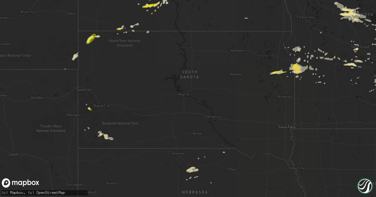
Hail Map in South Dakota on August 3, 2018
Get this storm
August 3 map
$229
one time, instant access
Download today. No call, no setup
Keep the $229
Bought the map and want the full workflow? Apply the entire $229 to a subscription within 7 days. None of it is wasted.
Every map, not just this one
This buys you this map. Subscription and you get every map we run, in the markets you choose from a few cities to whole states to nationwide. Plus real-time alerts the moment a storm fires.
Contact data
Name, contact info, occupancy, even credit band for addresses in the footprint. You go from where it hit to who to call.
Become the source they trust
Unlimited branding weather history reports on demand. You already have the documented answer ready for the property owner, and you are the one who showed up with it.
Property data and RoofTrace estimates
Pull up any address you have got, its value and the exact code rules for that jurisdiction, straight from One Click Code. Then RoofTrace estimates the squares, pitch, and roof value, priced the way you price.
Storm reports in South Dakota
South Dakota
| Date | Description |
|---|---|
| 08/03/20185:40 PM CDT | A local report indicates 1.00 inch wind near 4 S MYSTIC |
| 08/03/20184:35 PM CDT | Relayed via social media. Radar estimated time. |
| 08/03/20181:32 PM CDT | Report via social media. |
| 08/03/20186:06 AM CDT | At 1105 PM MDT, a severe thunderstorm was located near Red Elm, or near Dupree, moving northeast at 45 mph. HAZARD...60 mph wind gusts. SOURCE...Radar indicated. IMPACT...Expect damage to roofs, siding, and trees. Locations impacted include... Eagle Butte, Lantry, Timber Lake, Isabel, Firesteel, South Eagle Butte, Little Moreau Rec Area, Bear Creek, Green Grass and Parade. |
| 08/03/20185:56 AM CDT | At 1055 PM MDT, severe thunderstorms were located along a line extending from 5 miles northwest of Iron Lightning to 2 miles southwest of Red Elm to 5 miles north of Red Scaffold, moving east at 35 mph. HAZARD...60 mph wind gusts. SOURCE...Radar indicated. IMPACT...Expect damage to roofs, siding, and trees. Locations impacted include... Dupree, South Eagle Butte, Thunder Butte, Red Elm, Iron Lightning and Intersection of Cherry Creek and Sunnybrook Roads. |
| 08/03/20185:20 AM CDT | At 1019 PM MDT, a severe thunderstorm was located 9 miles north of North Lemmon, or 10 miles north of Lemmon, moving northeast at 20 mph. HAZARD...60 mph wind gusts and quarter size hail. SOURCE...Radar indicated. IMPACT...Hail damage to vehicles is expected. Expect wind damage to roofs, siding, and trees. This severe thunderstorm will remain over mainly rural areas of southeastern Hettinger...southwestern Grant and southeastern Adams Counties. |
| 08/03/20184:41 AM CDT | At 941 PM MDT, severe thunderstorms were located along a line extending from 6 miles northeast of Ludlow to 8 miles south of Slim Buttes, moving east at 35 mph. HAZARD...70 mph wind gusts and nickel size hail. SOURCE...Radar indicated. IMPACT...Expect considerable tree damage. Damage is likely to mobile homes, roofs, and outbuildings. Locations impacted include... Bison, Reva, Ralph, Chance, Lodgepole, Sorum, White Butte, Prairie City, Date, Slim Buttes, Owen Lake and southwestern Shadehill Reservoir. |
| 08/03/20184:07 AM CDT | At 906 PM MDT, a severe thunderstorm was located over Hettinger, moving east at 15 mph. HAZARD...60 mph wind gusts and half dollar size hail. SOURCE...Trained weather spotters. IMPACT...Hail damage to vehicles is expected. Expect wind damage to roofs, siding, and trees. Locations impacted include... Hettinger, Haynes, White Butte and North Lemmon. |
| 08/03/20184:00 AM CDT | At 859 PM MDT, severe winds from thunderstorms were located along a line extending from near Baker to near Gustave and Capitol, moving northeast at 30 mph. HAZARD...60 mph wind gusts. SOURCE...Radar indicated. IMPACT...Expect damage to roofs, siding, and trees. Locations impacted include... Baker, Webster, Ollie, Capitol, Willard and Mill Iron. |
| 08/03/20182:29 AM CDT | At 728 PM MDT, severe thunderstorms were located along a line extending from 10 miles northwest of Alva to 7 miles west of Clareton, moving east at 50 mph. HAZARD...60 mph wind gusts and quarter size hail. SOURCE...Radar indicated. IMPACT...Hail damage to vehicles is expected. Expect wind damage to roofs, siding, and trees. Locations impacted include... Spearfish, Belle Fourche, Newcastle, Lead, Sundance, Deadwood, Upton, Moorcroft, Pine Haven, Hulett, Osage, Saint Onge, Central City, Colony, Beulah, Fruitdale, Alva, Aladdin, Moon and Moskee.This Includes... Interstate 90 in South Dakota between Mile Markers 1 and 23. Interstate 90 in Wyoming between Mile Markers 148 and 207. |
| 08/02/201811:58 PM CDT | A local report indicates 63 MPH wind near 1 WSW RED ELM |
| 08/02/201811:53 PM CDT | A local report indicates 63 MPH wind near 1 WSW RED ELM |
| 08/02/201811:46 PM CDT | A local report indicates 66 MPH wind near 1 NNE FAITH |
| 08/02/201811:41 PM CDT | A local report indicates 59 MPH wind near 7 SSE MEADOW |
| 08/02/201811:41 PM CDT | At 441 PM CDT, a severe thunderstorm was located near Nassau, or 16 miles southeast of Milbank, moving east at 25 mph. HAZARD...60 mph wind gusts and half dollar size hail. SOURCE...Radar indicated. IMPACT...Hail damage to vehicles is expected. Expect wind damage to roofs, siding, and trees. This severe thunderstorm will be near... Bellingham around 450 PM CDT. Madison around 505 PM CDT. Dawson around 525 PM CDT.This includes the following highways... U.S. Highway 212 between mile markers 0 and 22. U.S. Highway 75 between mile markers 99 and 127. |
| 08/02/201811:35 PM CDT | At 435 PM MDT, a severe thunderstorm was located 3 miles north of Hill City, moving southeast at 15 mph. HAZARD...Quarter size hail. SOURCE...Radar indicated. IMPACT...Damage to vehicles is expected. Locations impacted include... Hill City, Keystone, Silver City, Rockerville, Pactola Reservoir, Mount Rushmore National Memorial, Keystone Wye, Sylvan Lake, Sheridan Lake, Black Elk Peak, Horse Thief Lake, and northwestern Custer State Park. |
| 08/02/201811:12 PM CDT | At 412 PM CDT, a severe thunderstorm was located near Waverly, or 7 miles east of Watertown, moving east at 20 mph. HAZARD...60 mph wind gusts and quarter size hail. SOURCE...Radar indicated. IMPACT...Hail damage to vehicles is expected. Expect wind damage to roofs, siding, and trees. Locations impacted include... Watertown, Waverly, Kranzburg, Goodwin, Strandburg, Troy, Bullhead Lake and School Lake. |
| 08/02/201810:56 PM CDT | A local report indicates 58 MPH wind near 1 ENE MUD BUTTE |
| 08/02/201810:48 PM CDT | Several large trees blown over with additional tree damage at elmwood golf course. |
| 08/02/201810:35 PM CDT | A local report indicates 66 MPH wind near 11 ESE BUFFALO |
| 08/02/201810:35 PM CDT | A local report indicates 66 MPH wind near 10 W REVA |
| 08/02/201810:31 PM CDT | A local report indicates 68 MPH wind near 8 N REDIG |
| 08/02/201810:20 PM CDT | Electrical poles snapped... County shop roof torn off on west side of town... Several trees with large limbs broken |
| 08/02/201810:17 PM CDT | A local report indicates 81 MPH wind near 1 N BUFFALO |
| 08/02/201810:11 PM CDT | A local report indicates 64 MPH wind near 12 WSW CASTLE ROCK |
| 08/02/201810:11 PM CDT | A local report indicates 58 MPH wind near 8 N REDIG |
| 08/02/201810:02 PM CDT | A local report indicates 60 MPH wind near 9 W HARDING |
| 08/02/20189:55 PM CDT | Large canopy tent blown into roadway. Power outages. |
| 08/02/20189:50 PM CDT | Rv damaged on highway 34 |
| 08/02/20189:21 PM CDT | A local report indicates 61 MPH wind near 13 NW DOWNTOWN BELLE FO |
| 08/02/20188:29 PM CDT | At 129 PM CDT, severe thunderstorms were located along a line extending from near Medicine Lake to 6 miles southwest of Kranzburg, moving northeast at 20 mph. HAZARD...Quarter size hail. SOURCE...Radar indicated. IMPACT...Damage to vehicles is expected. Locations impacted include... Watertown, Rauville, Waverly, Kranzburg, Goodwin, Watertown City Park, Dakota Sioux Casino, Bullhead Lake, School Lake, Lake Kampeska, Memorial Park Camping Site and Pelican Lake. |
All States Impacted by Hail Map on August 3, 2018
Cities Impacted by Hail Map on August 3, 2018
- Fifield, WI
- Park Falls, WI
- Clear Lake, SD
- Cottonwood, MN
- Goodland, KS
- Edson, KS
- Glidden, WI
- Iron Belt, WI
- Upson, WI
- Billings, MT
- Hettinger, ND
- Ellsworth, WI
- Elmwood, WI
- Washburn, WI
- Saint Paul, MN
- Saint Francis, KS
- Livingston, MT
- Saxon, WI
- Hurley, WI
- Rugby, ND
- Pierz, MN
- Hillman, MN
- Durham, NH
- Nottingham, NH
- Lee, NH
- Eau Claire, WI
- Fall Creek, WI
- Altoona, WI
- Hamilton, CO
- Craig, CO
- Barrington, NH
- Madbury, NH
- Lamar, CO
- Hot Springs, SD
- Oral, SD
- Saint Croix Falls, WI
- Balsam Lake, WI
- Woodville, WI
- Baldwin, WI
- Jordan, MN
- New Prague, MN
- Greenville, MO
- River Falls, WI
- Prentice, WI
- Annandale, MN
- Glen Ullin, ND
- Grove City, MN
- White Rock, NM
- Montreal, WI
- Ashland, WI
- Gile, WI
- Beldenville, WI
- Maiden Rock, WI
- Danbury, WI
- Cheneyville, LA
- Saint Landry, LA
- Wilson, WI
- Spring Valley, WI
- Onamia, MN
- Idalia, CO
- Kirk, CO
- Peridot, AZ
- Benkelman, NE
- Phillips, WI
- Avon, MN
- Enders, NE
- Imperial, NE
- Plum City, WI
- Anamoose, ND
- Mellen, WI
- Marengo, WI
- Trego, WI
- Watertown, SD
- North Platte, NE
- Hershey, NE
- Oakes, ND
- Clark, CO
- Benson, MN
- Murdock, MN
- Sunburg, MN
- Elsie, NE
- Ludlow, SD
- Mora, MN
- Pillager, MN
- Nisswa, MN
- Carson, ND
- Eau Galle, WI
- Menomonie, WI
- Madison, MN
- Marietta, MN
- Litchfield, MN
- Dassel, MN
- Darwin, MN
- Scandia, MN
- Forest Lake, MN
- Marine On Saint Croix, MN
- Hugo, MN
- Osceola, WI
- Medford, WI
- Avoca, MI
- Brewster, KS
- Graceville, MN
- Dequincy, LA
- Thompson, UT
- Isle, MN
- Wahkon, MN
- Lemmon, SD
- Minneapolis, MN
- Osseo, MN
- Maple Grove, MN
- Holly, CO
- Revillo, SD
- Milbank, SD
- Appleton, MN
- Bellingham, MN
- Dawson, MN
- Gary, SD
- Oldsmar, FL
- Flasher, ND
- Mandan, ND
- Ville Platte, LA
- Buffalo, SD
- Rosemount, MN
- Holloway, MN
- Montevideo, MN
- Spanish Fork, UT
- Bridger, MT
- Wray, CO
- Dover, NH
- Eden Prairie, MN
- Shakopee, MN
- Burnsville, MN
- Savage, MN
- Hastings, MN
- Inver Grove Heights, MN
- Prior Lake, MN
- Cushing, MN
- Motley, MN
- Drake, ND
- Lodgepole, SD
- Roberts, MT
- East Carbon, UT
- Odessa, MN
- Ainsworth, NE
- Johnstown, NE
- Glencoe, MN
- Hill City, SD
- Weskan, KS
- Arapahoe, CO
- Elgin, ND
- Almont, ND
- Center City, MN
- Weyerhaeuser, WI
- Rice Lake, WI
- Welch, MN
- Brantwood, WI
- Beardsley, MN
- Alzada, MT
- Capitol, MT
- Becker, MN
- Monticello, MN
- Milford, UT
- Palisade, NE
- Wauneta, NE
- New Richmond, WI
- Pine Ridge, SD
- Sebeka, MN
- Lecompte, LA
- Mcclusky, ND
- Lodge Grass, MT
- Karlsruhe, ND
- Brainerd, MN
- Champion, NE
- Hudson, WI
- North Branch, MN
- Pequot Lakes, MN
- Staples, MN
- Baxter, MN
- Santa Fe, NM
- Kimball, MN
- Cokato, MN
- South Haven, MN
- Buffalo, MN
- Maple Lake, MN
- Saint Cloud, MN
- Waite Park, MN
- Rockville, MN
- Cold Spring, MN
- Saint Michael, MN
- Salisbury, NH
- Franklin, NH
- Canterbury, NH
- Belmont, NH
- Gilmanton, NH
- Concord, NH
- Tilton, NH
- Gilmanton Iron Works, NH
- Delmar, NY
- Albany, NY
- Ravena, NY
- Feura Bush, NY
- Selkirk, NY
- Coeymans Hollow, NY
- Glenmont, NY
- Exeland, WI
- Hawkins, WI
- Glen Flora, WI
- Mondovi, WI
- Stanchfield, MN
- Cambridge, MN
- Ortonville, MN
- Sheridan Lake, CO
- Elk Mound, WI
- Wiley, CO
- New Leipzig, ND
- Saint Anthony, ND
- New Salem, ND
- Circle Pines, MN
- High Bridge, WI
- Roberts, WI
- Somerset, WI
- Burwell, NE
- Kennan, WI
- Catawba, WI
- Haugen, WI
- Mikana, WI
- Rib Lake, WI
- Ogema, WI
- Peever, SD
- Canby, MN
- La Pointe, WI
- Mercer, WI
- Winthrop, MN
- Spicer, MN
- New London, MN
- Forest Hill, LA
- Woodworth, LA
- Alexandria, LA
- Watkins, MN
- Greencastle, IN
- Le Sueur, MN
- Westboro, WI
- Spooner, WI
- Hager City, WI
- Prescott, WI
- Le Center, MN
- Shafer, MN
- Star Prairie, WI
- Centuria, WI
- Tryon, NE
- Sutherland, NE
- Sartell, MN
- Saint Joseph, MN
- Atwater, MN
- Pennock, MN
- Watauga, SD
- McNeal, AZ
- Merrill, WI
- Tomahawk, WI
- Denhoff, ND
- Carver, MN
- Lakeville, MN
- New Iberia, LA
- Hulett, WY
- Alva, WY
- Punta Gorda, FL
- Meeker, CO
- Garrison, MN
- Birchwood, WI
- Wallace, NE
- Barron, WI
- Vulcan, MI
- Niagara, WI
- Danvers, MN
- Wallace, KS
- Webster, MN
- Hayes Center, NE
- Washington Court House, OH
- Clinton, MN
- Sharon Springs, KS
- Moorcroft, WY
- Fort Ripley, MN
- Athens, WI
- Butte, NE
- Garita, NM
- Goodrich, ND
- Lindstrom, MN
- Kerkhoven, MN
- Levant, KS
- Yale, MI
- Clarkfield, MN
- McGrath, MN
- Starbuck, MN
- Hancock, MN
- Springview, NE
- Kirklin, IN
- Glenwood, MN
- Buffalo Gap, SD
- Sarona, WI
- Shell Lake, WI
- Cadott, WI
- Bena, MN
- Gallatin Gateway, MT
- Gypsum, CO
- Corona, SD
- Oak Park, MN
- Princeton, MN
- Frankfort, IN
- Sabina, OH
- Goodwin, SD
- Strandburg, SD
- Jamestown, OH
- Howard Lake, MN
- Rensselaer, NY
- Sandstone, MN
- Milaca, MN
- Ogilvie, MN
- Wolbach, NE
- Correll, MN
- Granite Falls, MN
- Butternut, WI
- Rapid River, MI
- Epsom, NH
- Suncook, NH
- Chichester, NH
- Bird City, KS
- Douglas, AZ
- Dickens, NE
- Brownton, MN
- Vernon, CO
- Mount Washington, KY
- Hinckley, MN
- Putney, VT
- Westmoreland, NH
- North Street, MI
- Echo, MN
- Belview, MN
- Hammond, WI
- Glenwood City, WI
- Wayzata, MN
- Long Lake, MN
- Hopkins, MN
- Hamel, MN
- Ragley, LA
- Emigrant, MT
- Sheldon, WI
- Garfield, MN
- Stewart, MN
- Thermopolis, WY
- Worland, WY
- Chokio, MN
- Stillwater, MN
- Amery, WI
- Dresser, WI
- Willernie, MN
- Minong, WI
- Afton, MN
- Draper, UT
- Butte, ND
- Conchas Dam, NM
- Newkirk, NM
- Arkansaw, WI
- Trementina, NM
- Trinchera, CO
- Browerville, MN
- Verndale, MN
- Sacred Heart, MN
- Cottage Grove, MN
- Edgemont, SD
- Wood Lake, MN
- Hanley Falls, MN
- Jeanerette, LA
- Frazee, MN
- Watson, MN
- Milan, MN
- Marcell, MN
- Bismarck, ND
- Crow Agency, MT
- Custer, SD
- Lorman, MS
- Detroit Lakes, MN
- Rolette, ND
- Pelahatchie, MS
- Alton Bay, NH
- Andover, NH
- North Sutton, NH
- Warner, NH


