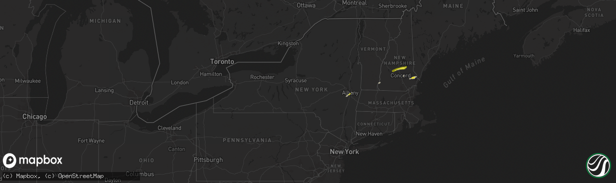
Hail Map in New York on August 3, 2018
The weather event in New York on August 3, 2018 includes Hail map. 23 states and 387 cities were impacted and suffered possible damage. The total estimated number of properties impacted is 1,686.
Want more than just the map?
Turn this storm into a full workflow.
- Owner + property data so you know who to knock
- OnDemand branded weather history reports to win the "did we even have hail?" argument
- RoofTrace estimate so reps stop guessing numbers at the door
Bought this map? Upgrade within 7 days and we'll credit the $230. (10-15 min setup call)
Hail
1,686
Estimated number of impacted properties by a 1.00" hail or larger0
Estimated number of impacted properties by a 1.75" hail or larger0
Estimated number of impacted properties by a 2.50" hail or largerStorm reports in New York
New York
| Date | Description |
|---|---|
| 08/03/20183:27 PM CDT | Numerous trees and wires down |
| 08/03/20183:26 PM CDT | Large tree limbs down |
| 08/03/20183:03 PM CDT | Trees down on wires on callicoon center road near sander road. |
| 08/03/20183:02 PM CDT | Tree limbs down |
| 08/03/20182:59 PM CDT | 2 large trees down |
| 08/03/20182:56 PM CDT | Wires pulled from house on peter cooper dr |
| 08/03/20182:50 PM CDT | Tree on house on merrywood rd |
| 08/03/20182:45 PM CDT | Power lines down. |
| 08/03/20182:40 PM CDT | Numerous trees and wires down. |
| 08/03/20182:40 PM CDT | Tree down at the intersection of city terrace and van ness street. |
| 08/03/20182:31 PM CDT | Numerous reports of trees and wires down around town...including trees down at the intersection of 9w and state route 293 and 9w and state route 218 |
| 08/03/20182:23 PM CDT | Tree branch down blocking teatown road. |
| 08/03/20182:16 PM CDT | Tree down blocking filors lane. Also a few other reports of trees down elsewhere around town. |
| 08/03/20182:05 PM CDT | Trees and wires down on cherry lane between south lorna lane and edgebrook lane. |
| 08/03/20181:15 PM CDT | Large tree limbs and wires down |
| 08/03/201812:48 PM CDT | Route 144 between corning hill road and feura bush rd is closed due to trees and wires down. |
| 08/03/201812:30 PM CDT | Wires down |
| 08/03/20186:18 AM CDT | At 1118 AM EDT, a severe thunderstorm was located over Harvard, or 10 miles south of Walton, moving northeast at 30 mph. HAZARD...60 mph wind gusts. SOURCE...Radar indicated. IMPACT...Expect damage to roofs, siding, and trees. Locations impacted include... Roxbury, Andes, Margaretville, Fleischmanns, Arkville, Harvard, Bovina Center, Downsville, Corbett and East Branch. |
| 08/03/201812:19 AM CDT | At 519 PM EDT, severe thunderstorms were located along a line extending from near Lenox to Becket, moving north at 40 mph. HAZARD...60 mph wind gusts. SOURCE...Radar indicated. IMPACT...Expect damage to roofs, siding, and trees. Severe thunderstorms will be near... Hancock around 535 PM EDT. Cheshire around 540 PM EDT. Savoy, Hawley and New Ashford around 545 PM EDT. Adams around 550 PM EDT. North Adams, Williamstown and Florida around 555 PM EDT.Other locations impacted by these severe thunderstorms includeHairpin Turn, Barkerville, Greylock, Soldiers Memorial Field, NorthHancock, Cheshire Harbor, Arnoldville, Glendale, Williamsville andLenox Dale. |
| 08/02/201810:43 PM CDT | At 342 PM EDT, severe thunderstorms were located along a line extending from near Walden to near Cold Spring, moving northeast at 35 mph. HAZARD...60 mph wind gusts. SOURCE...Radar indicated. IMPACT...Expect damage to trees and power lines. Locations impacted include... Newburgh, Walden, Cold Spring, New Windsor, Gardnertown, Montgomery, Woodbury, Orange Lake, Washingtonville, Firthcliffe, Vails Gate, Balmville, Cornwall On Hudson and Maybrook. |
| 08/02/20189:52 PM CDT | At 251 PM EDT, a severe thunderstorm was located over Prompton, or near Honesdale, moving northeast at 25 mph. HAZARD...60 mph wind gusts and penny size hail. SOURCE...Radar indicated. IMPACT...Expect damage to roofs, siding, and trees. Locations impacted include... Honesdale, Damascus, Waymart, Prompton, Bethany, Stalker, Equinunk, Rutledgedale, Hankins and Browndale. |
All States Impacted by Hail Map on August 3, 2018
Cities Impacted by Hail Map on August 3, 2018
- Fifield, WI
- Park Falls, WI
- Clear Lake, SD
- Cottonwood, MN
- Goodland, KS
- Edson, KS
- Glidden, WI
- Iron Belt, WI
- Upson, WI
- Billings, MT
- Hettinger, ND
- Ellsworth, WI
- Elmwood, WI
- Washburn, WI
- Saint Paul, MN
- Saint Francis, KS
- Livingston, MT
- Saxon, WI
- Hurley, WI
- Rugby, ND
- Pierz, MN
- Hillman, MN
- Durham, NH
- Nottingham, NH
- Lee, NH
- Eau Claire, WI
- Fall Creek, WI
- Altoona, WI
- Hamilton, CO
- Craig, CO
- Barrington, NH
- Madbury, NH
- Lamar, CO
- Hot Springs, SD
- Oral, SD
- Saint Croix Falls, WI
- Balsam Lake, WI
- Woodville, WI
- Baldwin, WI
- Jordan, MN
- New Prague, MN
- Greenville, MO
- River Falls, WI
- Prentice, WI
- Annandale, MN
- Glen Ullin, ND
- Grove City, MN
- White Rock, NM
- Montreal, WI
- Ashland, WI
- Gile, WI
- Beldenville, WI
- Maiden Rock, WI
- Danbury, WI
- Cheneyville, LA
- Saint Landry, LA
- Wilson, WI
- Spring Valley, WI
- Onamia, MN
- Idalia, CO
- Kirk, CO
- Peridot, AZ
- Benkelman, NE
- Phillips, WI
- Avon, MN
- Enders, NE
- Imperial, NE
- Plum City, WI
- Anamoose, ND
- Mellen, WI
- Marengo, WI
- Trego, WI
- Watertown, SD
- North Platte, NE
- Hershey, NE
- Oakes, ND
- Clark, CO
- Benson, MN
- Murdock, MN
- Sunburg, MN
- Elsie, NE
- Ludlow, SD
- Mora, MN
- Pillager, MN
- Nisswa, MN
- Carson, ND
- Eau Galle, WI
- Menomonie, WI
- Madison, MN
- Marietta, MN
- Litchfield, MN
- Dassel, MN
- Darwin, MN
- Scandia, MN
- Forest Lake, MN
- Marine On Saint Croix, MN
- Hugo, MN
- Osceola, WI
- Medford, WI
- Avoca, MI
- Brewster, KS
- Graceville, MN
- Dequincy, LA
- Thompson, UT
- Isle, MN
- Wahkon, MN
- Lemmon, SD
- Minneapolis, MN
- Osseo, MN
- Maple Grove, MN
- Holly, CO
- Revillo, SD
- Milbank, SD
- Appleton, MN
- Bellingham, MN
- Dawson, MN
- Gary, SD
- Oldsmar, FL
- Flasher, ND
- Mandan, ND
- Ville Platte, LA
- Buffalo, SD
- Rosemount, MN
- Holloway, MN
- Montevideo, MN
- Spanish Fork, UT
- Bridger, MT
- Wray, CO
- Dover, NH
- Eden Prairie, MN
- Shakopee, MN
- Burnsville, MN
- Savage, MN
- Hastings, MN
- Inver Grove Heights, MN
- Prior Lake, MN
- Cushing, MN
- Motley, MN
- Drake, ND
- Lodgepole, SD
- Roberts, MT
- East Carbon, UT
- Odessa, MN
- Ainsworth, NE
- Johnstown, NE
- Glencoe, MN
- Hill City, SD
- Weskan, KS
- Arapahoe, CO
- Elgin, ND
- Almont, ND
- Center City, MN
- Weyerhaeuser, WI
- Rice Lake, WI
- Welch, MN
- Brantwood, WI
- Beardsley, MN
- Alzada, MT
- Capitol, MT
- Becker, MN
- Monticello, MN
- Milford, UT
- Palisade, NE
- Wauneta, NE
- New Richmond, WI
- Pine Ridge, SD
- Sebeka, MN
- Lecompte, LA
- Mcclusky, ND
- Lodge Grass, MT
- Karlsruhe, ND
- Brainerd, MN
- Champion, NE
- Hudson, WI
- North Branch, MN
- Pequot Lakes, MN
- Staples, MN
- Baxter, MN
- Santa Fe, NM
- Kimball, MN
- Cokato, MN
- South Haven, MN
- Buffalo, MN
- Maple Lake, MN
- Saint Cloud, MN
- Waite Park, MN
- Rockville, MN
- Cold Spring, MN
- Saint Michael, MN
- Salisbury, NH
- Franklin, NH
- Canterbury, NH
- Belmont, NH
- Gilmanton, NH
- Concord, NH
- Tilton, NH
- Gilmanton Iron Works, NH
- Delmar, NY
- Albany, NY
- Ravena, NY
- Feura Bush, NY
- Selkirk, NY
- Coeymans Hollow, NY
- Glenmont, NY
- Exeland, WI
- Hawkins, WI
- Glen Flora, WI
- Mondovi, WI
- Stanchfield, MN
- Cambridge, MN
- Ortonville, MN
- Sheridan Lake, CO
- Elk Mound, WI
- Wiley, CO
- New Leipzig, ND
- Saint Anthony, ND
- New Salem, ND
- Circle Pines, MN
- High Bridge, WI
- Roberts, WI
- Somerset, WI
- Burwell, NE
- Kennan, WI
- Catawba, WI
- Haugen, WI
- Mikana, WI
- Rib Lake, WI
- Ogema, WI
- Peever, SD
- Canby, MN
- La Pointe, WI
- Mercer, WI
- Winthrop, MN
- Spicer, MN
- New London, MN
- Forest Hill, LA
- Woodworth, LA
- Alexandria, LA
- Watkins, MN
- Greencastle, IN
- Le Sueur, MN
- Westboro, WI
- Spooner, WI
- Hager City, WI
- Prescott, WI
- Le Center, MN
- Shafer, MN
- Star Prairie, WI
- Centuria, WI
- Tryon, NE
- Sutherland, NE
- Sartell, MN
- Saint Joseph, MN
- Atwater, MN
- Pennock, MN
- Watauga, SD
- McNeal, AZ
- Merrill, WI
- Tomahawk, WI
- Denhoff, ND
- Carver, MN
- Lakeville, MN
- New Iberia, LA
- Hulett, WY
- Alva, WY
- Punta Gorda, FL
- Meeker, CO
- Garrison, MN
- Birchwood, WI
- Wallace, NE
- Barron, WI
- Vulcan, MI
- Niagara, WI
- Danvers, MN
- Wallace, KS
- Webster, MN
- Hayes Center, NE
- Washington Court House, OH
- Clinton, MN
- Sharon Springs, KS
- Moorcroft, WY
- Fort Ripley, MN
- Athens, WI
- Butte, NE
- Garita, NM
- Goodrich, ND
- Lindstrom, MN
- Kerkhoven, MN
- Levant, KS
- Yale, MI
- Clarkfield, MN
- McGrath, MN
- Starbuck, MN
- Hancock, MN
- Springview, NE
- Kirklin, IN
- Glenwood, MN
- Buffalo Gap, SD
- Sarona, WI
- Shell Lake, WI
- Cadott, WI
- Bena, MN
- Gallatin Gateway, MT
- Gypsum, CO
- Corona, SD
- Oak Park, MN
- Princeton, MN
- Frankfort, IN
- Sabina, OH
- Goodwin, SD
- Strandburg, SD
- Jamestown, OH
- Howard Lake, MN
- Rensselaer, NY
- Sandstone, MN
- Milaca, MN
- Ogilvie, MN
- Wolbach, NE
- Correll, MN
- Granite Falls, MN
- Butternut, WI
- Rapid River, MI
- Epsom, NH
- Suncook, NH
- Chichester, NH
- Bird City, KS
- Douglas, AZ
- Dickens, NE
- Brownton, MN
- Vernon, CO
- Mount Washington, KY
- Hinckley, MN
- Putney, VT
- Westmoreland, NH
- North Street, MI
- Echo, MN
- Belview, MN
- Hammond, WI
- Glenwood City, WI
- Wayzata, MN
- Long Lake, MN
- Hopkins, MN
- Hamel, MN
- Ragley, LA
- Emigrant, MT
- Sheldon, WI
- Garfield, MN
- Stewart, MN
- Thermopolis, WY
- Worland, WY
- Chokio, MN
- Stillwater, MN
- Amery, WI
- Dresser, WI
- Willernie, MN
- Minong, WI
- Afton, MN
- Draper, UT
- Butte, ND
- Conchas Dam, NM
- Newkirk, NM
- Arkansaw, WI
- Trementina, NM
- Trinchera, CO
- Browerville, MN
- Verndale, MN
- Sacred Heart, MN
- Cottage Grove, MN
- Edgemont, SD
- Wood Lake, MN
- Hanley Falls, MN
- Jeanerette, LA
- Frazee, MN
- Watson, MN
- Milan, MN
- Marcell, MN
- Bismarck, ND
- Crow Agency, MT
- Custer, SD
- Lorman, MS
- Detroit Lakes, MN
- Rolette, ND
- Pelahatchie, MS
- Alton Bay, NH
- Andover, NH
- North Sutton, NH
- Warner, NH


